Silvi Pasture [Índia]
- Criação:
- Atualização:
- Compilador/a: Unknown User
- Editor: –
- Revisores: Fabian Ottiger, Alexandra Gavilano
Nursery
technologies_1470 - Índia
Veja as seções
Expandir tudo Recolher tudo1. Informação geral
1.2 Detalhes do contato das pessoas capacitadas e instituições envolvidas na avaliação e documentação da tecnologia
Pessoa(s) capacitada(s)
Especialista em GST:
Mewara Ramesh
Índia
1.3 Condições em relação ao uso da informação documentada através de WOCAT
O/a compilador/a e a(s) pessoa(s) capacitada(s) aceitam as condições relativas ao uso de dados documentados através da WOCAT:
Sim
1.5 Referência ao(s) questionário(s) sobre abordagens GST (documentado(s) usando WOCAT)
Comprehensive watershed development [Índia]
Participatory approach that includes a package of measures leading to empowerment of communities to implement and sustain watershed development.
- Compilador/a: David Gandhi
2. Descrição da tecnologia de GST
2.1 Descrição curta da tecnologia
Definição da tecnologia:
Regeneration of degraded hill side using structural, vegetative & managerial measures.
2.2 Descrição detalhada da tecnologia
Descrição:
Managerial Measures : awareness generation amongst community, users groups, area closure, cut & carry system; Structural Measures :- contour trenches, gully plugs, sunken structure for run off and erosion control; Vegetative Measures :- seeding of grasses and shrubs, plantation of dryland fruit & forest tree species, vegetative barriers across slopes & gullies.
Purpose of the Technology: Short term benefits :- increased fodder availability, increase in well water levels, increased soil moisture in foot hill crop lands; Long term benefits :- environmental regeneration leading to increased production from non-arable & surrounding arable lands.
2.3 Fotos da tecnologia
Galeria de Mídias
2.5 País/região/locais onde a tecnologia foi aplicada e que estão cobertos nesta avaliação
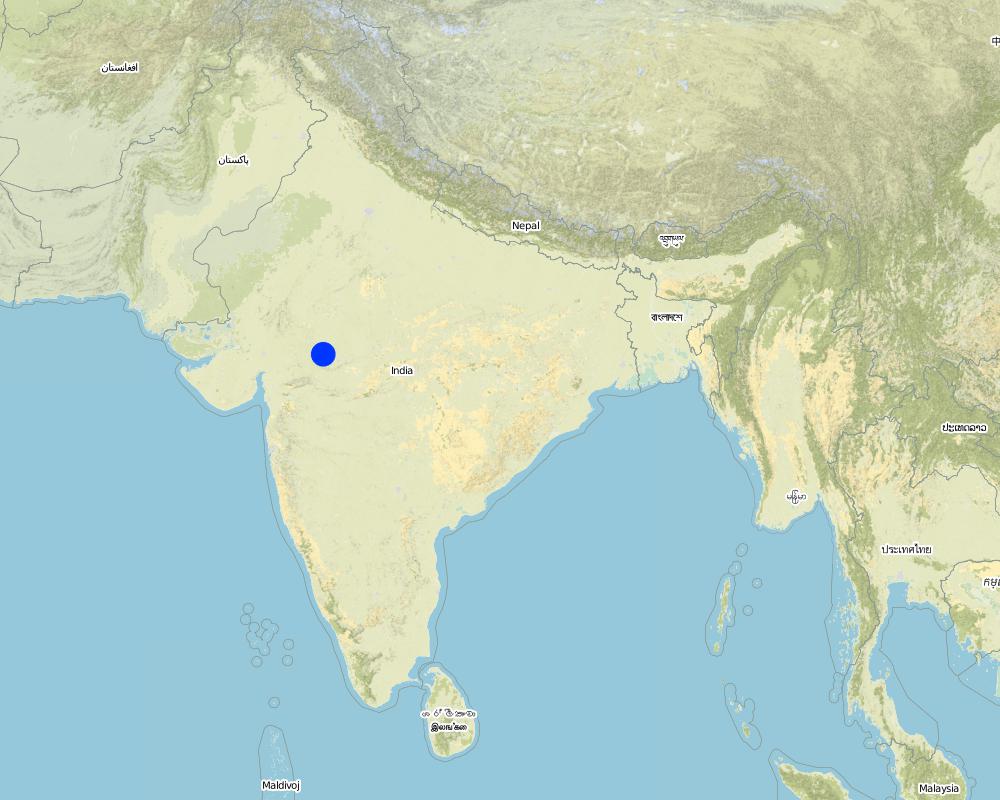
País:
Índia
Região/Estado/Província:
Madhya Pradesh
Especifique a difusão da tecnologia:
- Uniformemente difundida numa área
Se a Tecnologia estiver uniformemente distribuída por uma área, especifique a área coberta (em km2):
79,33
Se a área precisa não for conhecida, indicar a área aproximada coberta:
- 10-100 km2
Comentários:
Total area covered by the SLM Technology is 79.33 km2.
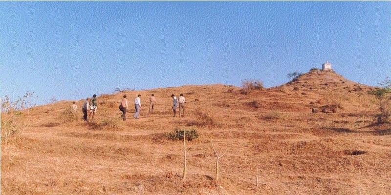
The project area comprises 26 villages (2286 HH) mainly tribal. A significant portion of the area is uncultivable waste which is used for open grazing. The technology "Silvi-Pasture" was implemented in few villages to demonstrate an integrated system of SWC and production.
Map
×2.6 Data da implementação
Caso o ano exato seja desconhecido, indique a data aproximada:
- menos de 10 anos atrás (recentemente)
2.7 Introdução da tecnologia
Especifique como a tecnologia foi introduzida:
- através de projetos/intervenções externas
Comentários (tipos de projeto, etc.):
Learning from visits to successful watershed development projects.
3. Classificação da tecnologia de GST
3.1 Principal/principais finalidade(s) da tecnologia
- Melhora a produção
- Reduz, previne, recupera a degradação do solo
3.2 Tipo(s) atualizado(s) de uso da terra onde a tecnologia foi aplicada
Uso do solo misturado dentro da mesma unidade de terra:
Sim
Especificar o uso misto da terra (culturas/ pastoreio/ árvores):
- Silvipecuária

Terra de cultivo
- Cultura anual
- Cultura de árvores e arbustos
Cultivo anual - Especificar culturas:
- culturas forrageiras - gramíneas
Cultivo de árvores e arbustos - Especificar culturas:
- frutas, outros
Número de estações de cultivo por ano:
- 2
Especifique:
Longest growing period in days: 120 Longest growing period from month to month: Jun - Oct Second longest growing period in days: 120 Second longest growing period from month to month: Nov - Mar

Pastagem
Pastagem intensiva/produção de forragem:
- Semiestabulação/sem pastagem

Floresta/bosques
Tipo de árvore:
- Azadirachta indica
- Jatropha, Salai (cf. Boswellia serrata), Lantana
Comentários:
Major land use problems (compiler’s opinion): Grass land :- Degradation due to over grazing; Crop Land :- Low yeilds due to erosion, low soil moisture, improper cultivation practices on sloping lands.
Major land use problems (land users’ perception): Low yields of grass and crops
Trees/ shrubs species: Jatropha, Salai, Neem (Azadirachta indica), Lantana
Fruit trees / shrubs species: Awla (goose berry)
Grass species: Stylo Hemata, Dicanthus(Dinanath)
3.4 Abastecimento de água
Abastecimento de água para a terra na qual a tecnologia é aplicada:
- Precipitação natural
Comentários:
Water supply: Also mixed rainfed - irrigated
3.5 Grupo de GST ao qual pertence a tecnologia
- Reserva ( suspensão do uso, apoio à recuperação)
- Medidas de curva de nível
- Gestão de água de superfície (nascente, rio, lagos, mar)
3.7 Principais tipos de degradação da terra abordados pela tecnologia

Erosão do solo pela água
- Wt: Perda do solo superficial/erosão de superfície
- Wg: Erosão por ravinas/ravinamento

Degradação da água
- Ha: aridificação
Comentários:
Main type of degradation addressed: Wt: loss of topsoil / surface erosion
Secondary types of degradation addressed: Wg: gully erosion / gullying, Ha: aridification
Main causes of degradation: other human induced causes (specify) (Social causes - Lack of awareness and mobilisation amongst the communities.), Top down approach (Macro planning rather than micro (village level) planning.)
4. Especificações técnicas, implementação de atividades, entradas e custos
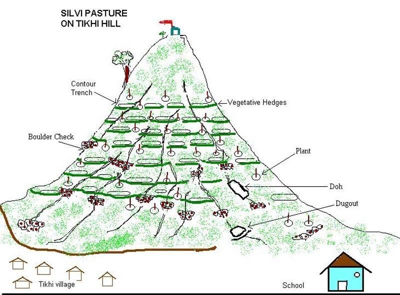
4.1 Desenho técnico da tecnologia
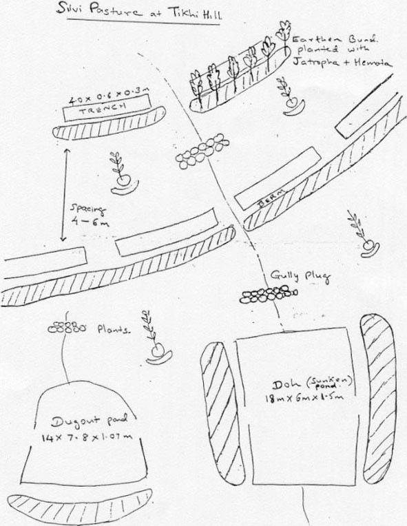
Especificações técnicas (relacionada ao desenho técnico):
Technical Drawing of SWC technology area, Tikhipada
Technical knowledge required for field staff / advisors: moderate
Technical knowledge required for land users: moderate
Main technical functions: control of dispersed runoff: retain / trap
Secondary technical functions: control of raindrop splash, control of concentrated runoff: retain / trap, control of concentrated runoff: impede / retard
Trees/ shrubs species: Jatropha, Salai, Neem, Lantana
Fruit trees / shrubs species: Awla (goose berry)
Grass species: Stylo Hemata, Dicanthus(Dinanath)
Slope (which determines the spacing indicated above): 35.00%
Construction material (earth): Excavation of earth for trenches/ditchs/pans
Construction material (stone): Stone plugs in gullies
Construction material (other): Vegetative support to stone plugs & ditches
Slope (which determines the spacing indicated above): 35%
Vegetation is used for stabilisation of structures.
Change of land use type: land use planning - Silvi Pasture
Change of land use practices / intensity level: land use change - Area Closure
Control / change of species composition: livestock management - Cut & carry system
Other type of management: Management by community( User Group)
Autor:
David Gandhi
4.2 Informação geral em relação ao cálculo de entradas e custos
Outro/moeda nacional (especifique):
Rupees
Se for relevante, indique a taxa de câmbio do USD para moeda local (por exemplo, 1 USD = 79,9 Real): 1 USD =:
48,85
Indique a média salarial da mão-de-obra contratada por dia:
1.00
4.3 Atividades de implantação
| Atividade | Periodicidade (estação do ano) | |
|---|---|---|
| 1. | Digging of plantation pit | Summer |
| 2. | Procurement of seeds, plants | Before rainy sesion |
| 3. | Sowing of grass & shrub seeds | Before Ist shower |
| 4. | Planting of saplings | After Ist heavy shawer |
| 5. | Survey/Layout | April (summer) |
| 6. | Excavation of ditches | May |
| 7. | Transportation of stones to site | May |
| 8. | Construction of sediment/sand trap | May |
| 9. | Excavation of Pan(Doh) | May 2nd year |
| 10. | Discussion with community & exposure visit | Feb |
| 11. | Formation of users group, meeting, preparation of action plan | March |
| 12. | Establishment of structural measures & training of users group | April-Jun |
| 13. | Establishment of vegetative meassures | July-Sep. |
| 14. | Area Closure | April-Oct. |
| 15. | Harvesting & distribution of grass by users group | Oct.-Nov. |
4.4 Custos e entradas necessárias para a implantação
Comentários:
Duration of establishment phase: 24 month(s)
4.5 Atividades recorrentes/manutenção
| Atividade | Periodicidade/frequência | |
|---|---|---|
| 1. | Weeding , mulching | 2-3 month after planting /Twice in year for Ist 2 year |
| 2. | Watering | Dry season /During prolonged dry spells |
| 3. | Reseeding of grass/shrubs | Before Ist shower /Upto 2 years |
| 4. | Casualty replacement | After Ist heavy shower /Year 1 & II |
| 5. | Repair of breaches in ditches/traps | July-Sep. during mansoon/As required |
| 6. | Construction of additional traps | July-Sep. during mansoon/As required |
| 7. | Desilting of Ditches/traps/Pans | Oct.-Nov. after mansoon/Annually |
| 8. | Refresher training of users group | Seasonally / |
| 9. | Regular meeting of users group | / 3 times/year |
| 10. | "Shramdan" ( Voluntary labour by usersfor maintenance) |
4.6 Custos e entradas necessárias pata a manutenção/atividades recorrentes (por ano)
Comentários:
The treatment covered an area of aroung 10 ha. 1- Contour Trenches - 6000 Rmt. 2- Large Boulder Check - 58 3- Small Boulder Check - 55 4- Dugout - 1 No. 5- Doh - 1 No. Seeding with jatropha, stylo and dinanath. Planting of saplings.
4.7 Fatores mais importantes que afetam os custos
Descreva os fatores mais determinantes que afetam os custos:
1- Slope : - Due to steep slope , interval between contour trench lines was less; 2- Soil Depth : - Due to stony strata, excavation cost was high; 3- Material : - Boulders were transported from outside. 4- Lead/Lift : - Due to steep slope, labour output was less 5- Drought :- Replantation costs were high
5. Ambiente natural e humano
5.1 Clima
Precipitação pluviométrica anual
- <250 mm
- 251-500 mm
- 501-750 mm
- 751-1.000 mm
- 1.001-1.500 mm
- 1.501-2.000 mm
- 2.001-3.000 mm
- 3.001-4.000 mm
- > 4.000 mm
Especifique a média pluviométrica anual em mm (se conhecida):
800,00
Especificações/comentários sobre a pluviosidade:
However during 1999 to 2002 below average
Zona agroclimática
- Semiárido
- Árido
Semi arid (ranked1)
Arid (ranked 2, due to 3 years of below avg. rainfall, signs of desertification eg. thorny species, lowering of water levels in wells are apparent)
5.2 Topografia
Declividade média:
- Plano (0-2%)
- Suave ondulado (3-5%)
- Ondulado (6-10%)
- Moderadamente ondulado (11-15%)
- Forte ondulado (16-30%)
- Montanhoso (31-60%)
- Escarpado (>60%)
Formas de relevo:
- Planalto/planície
- Cumes
- Encosta de serra
- Encosta de morro
- Sopés
- Fundos de vale
Zona de altitude:
- 0-100 m s.n.m.
- 101-500 m s.n.m.
- 501-1.000 m s.n.m.
- 1.001-1.500 m s.n.m.
- 1.501-2.000 m s.n.m.
- 2.001-2.500 m s.n.m.
- 2.501-3.000 m s.n.m.
- 3.001-4.000 m s.n.m.
- > 4.000 m s.n.m.
Comentários e outras especificações sobre a topografia:
Landforms: Hill slopes (ranked 1) and ridges (ranked 2, isolated hillcock)
Slopes on average: Steep (ranked 1, conical Shaped hillock - upper slope > 30%) and hilly (ranked 2, conical Shaped hillock - lower slope < 30%)
5.3 Solos
Profundidade do solo em média:
- Muito raso (0-20 cm)
- Raso (21-50 cm)
- Moderadamente profundo (51-80 cm)
- Profundo (81-120 cm)
- Muito profundo (>120 cm)
Textura do solo (solo superficial):
- Grosso/fino (arenoso)
Matéria orgânica do solo superficial:
- Baixo (<1%)
Caso disponível anexe a descrição completa do solo ou especifique as informações disponíveis, p. ex. tipo de solo, PH/acidez do solo, nitrogênio, capacidade de troca catiônica, salinidade, etc.
Soil depth on average: Very shallow (highly eroded surface, exposed parent rock)
Soil texture: Coarse/light (weathered fragments(Kopra))
Soil fertility: Very low (absence of soil)
Topsoil organic matter: Low (absence of vegetation)
Soil drainage/infiltration: Poor (high runoff from stony surface)
Soil water storage capacity: Very low (high runoff from stony surface)
5.6 Características dos usuários da terra que utilizam a tecnologia
Rendimento não agrícola:
- 10-50% de toda renda
Nível relativo de riqueza:
- Muito pobre
- Pobre
Indique outras características relevantes dos usuários da terra:
Population density: 50-100 persons/km2
18% of the land users are average wealthy (4 H.H.).
59% of the land users are poor (13 H.H.).
23% of the land users are poor (5 H.H.).
Off-farm income specification: Around 10% of the total income is from paid labour/migration
5.8 Propriedade de terra, direitos de uso da terra e de uso da água
Propriedade da terra:
- Comunitário/rural
Direitos do uso da terra:
- Comunitário (organizado)
6. Impactos e declarações finais
6.4 Análise do custo-benefício
Como os benefícios se comparam aos custos de implantação (do ponto de vista dos usuários da terra)?
Retornos a curto prazo:
negativo
Retornos a longo prazo:
positivo
Como os benefícios se comparam aos custos recorrentes/de manutenção(do ponto de vista dos usuários da terra)?
Retornos a curto prazo:
levemente positivo
Retornos a longo prazo:
positivo
6.5 Adoção da tecnologia
Comentários:
15% of land user families have adopted the Technology with external material support
340 land user families have adopted the Technology with external material support
Comments on acceptance with external material support: survey results
There is a little trend towards spontaneous adoption of the Technology
Comments on adoption trend: Elemets of the technology have been adopted by land users eg. SWC, grass improvement. There is tremendous pressure on grass land due to large number of local cattle & goats, migratory herds of camel & sheeps. Hence spontaneous adoption is not observed since community mobilisation is essential as also efforts for user rights.
7. Referências e links
7.1 Métodos/fontes de informação
Links e módulos
Expandir tudo Recolher tudoLinks
Comprehensive watershed development [Índia]
Participatory approach that includes a package of measures leading to empowerment of communities to implement and sustain watershed development.
- Compilador/a: David Gandhi
Módulos
Não há módulos