Dawa-Cheffa Traditional Checkdam [Эфиопия]
- Создание:
- Обновить:
- Составитель: Unknown User
- Редактор: –
- Рецензенты: Fabian Ottiger, Alexandra Gavilano
Kiter
technologies_1058 - Эфиопия
Просмотреть разделы
Развернуть все Свернуть все1. Общая информация
1.2 Контактные данные специалистов и организаций, участвующих в описании и оценке Технологии
Ответственный (-ые) специалист (-ы)
Специалист по УЗП:
Umer Kemal
Dewa Chefe Woreda Agriculture and Rural Development Office (DWARAO)
Эфиопия
Название организации (-ий), содействовавших документированию/оценке Технологии (если применимо)
Ministry of Agriculture and Rural Development (Ministry of Agriculture and Rural Development) - Эфиопия1.3 Условия, регламентирующие использование данных, собранных ВОКАТ
Составитель и ответственный(-ые) специалист(-ы) согласны с условиями, регламентирующими использование собранных ВОКАТ данных:
Да
2. Описание Технологии УЗП
2.1 Краткое описание Технологии
Определение Технологии:
A structural measure constructed by stone/soil/wood acrross the gully to control erosion and create favourble condition for crop cultivation.
2.2 Подробное описание Технологии
Описание:
The technology is known by the farmers for more than a century. Since the area is highly affected by gully erosion, this practice is widely used by farmers in the area and also widely practiced. Its construction starts from the bottom of the gully and proceeds upslope with different dimensions. The height depends on the depth of the gully and it is increased from year to year. On the average the width is 1m and hieght is 1.80m. The technology is used to develop big gullies and treatment of small gully like depressions, attain slope change to enhance land suitability to crop production and to conserve soil and water. The construction of the stone checkdam starts with small heights and some height is added every year until the intended height is reached. The increase in height could be done during maintenance also. The major objective being to stop gully growth, trap sediment and retain water running down the gully. In the course of increasing the height, the area for sediment deposition gets wider. The technology is suitable to areas with low rainfalls of rugged topography having a network of gullies.
2.5 Страна/ регион/ места, где применяется Технология, информация о которых собрана в данной Анкете
Страна:
Эфиопия
Административная единица (Район/Область):
Amhara Regional State
Более точная привязка места:
Koshem Watershed
Охарактеризуйте пространственное распространение Технологии :
- равномерно-однородное применение на определенной площади
Если точная область неизвестна, укажите приблизительную площадь:
- 10-100 км2
Пояснения:
Total area covered by the SLM Technology is 810 km2.
The technology is mostly practiced in the eastern escarpment of the the woreda experiencing low and erratic rains. Area is estimated
Map
×2.6 Сколько лет применяется данная Технология
Если год начала применения Технологии достоверно неизвестен, дайте примерную оценку:
- более 50 лет назад (традиционная)
2.7 Внедрение Технологии
Укажите, как именно Технология УЗП была внедрена:
- как часть традиционной системы землепользования (более 50 лет назад)
Пояснения (тип проекта и т.д.):
Is developed by land users themselves
3. Классификация Технологии УЗП
3.1 Основные цели и задачи реализации Технологии
- повышение производства
- снижение или предотвращение деградации земель, восстановление нарушенных земель
3.2 Текущий(-ие) тип(-ы) землепользования на территории, где применяется Технология

Пахотные угодья и плантации
- Однолетние культуры
- Многолетние (недревесные) культуры
- Древесные и кустарниковые культуры
Ежегодный урожай - Уточните культуры:
- зерновые культуры - кукуруза
- зерновые культуры - сорго
- бобовые - бобы
- бобовые - другие
- масличные культуры - подсолнечник, рапс, другие
- haricot bean, teff
- sugar cane, elephant grass, local grass
Древесные и кустарниковые культуры - Уточните культуры:
- цитрусовые
- кофе, открытое выращивание
- другие фрукты
- манго, мангостан, гуава
- папайя
- acacia, eucalyptus, khata edulis, ageava sisal, banana, lemon
Число урожаев за год:
- 2
Поясните:
Longest growing period in days: 210 Longest growing period from month to month: May - Nov Second longest growing period in days: 180 Second longest growing period from month to month: Jan - Apr
Применяются ли посевы в междурядьях?
Да
Если да, укажите, какие посевы применяются:
sorghum/maize +haricot beans

Пастбищные угодья

Леса/ лесистая местность
- (Квази-) Природные леса/ лесные массивы
(Квази-) Природные леса / лесные массивы: Укажите тип управления:
- Сплошные рубки
Продукции и услуги:
- Древесина
- Дрова
- Выпас/ ощипывание молодых побегов и листьев
Пояснения:
Major land use problems (compiler’s opinion): Increase in human and animal population, overggrazing and expansion of cultivated lands to areas which are not suitable to cultivation is a problem. Meanwhile, owing to gully expansion and in the absence of preventive and control measures, there is considerable loss of soil from grazing and cultivated lands.
Major land use problems (land users’ perception): More area is getting out of production.
Other grazingland: extensive: pastoralism: in the eastern side of the SWC technology area
Other grazingland: extensive: semi-pastoralism: on the ridgea nd hilly slopes where land users are engaged in crop and livestock production
Grazingland comments: Livestock production is decreasing primarily because of decreasing grazing lands. The number of livestock being the most important factor for herd owners than the quailty. More extension work will be needed to promot the awarness of livestock owners in a way they give emphases to quality of livestock production than numbers.
Clear felling of (semi-)natural forests: to open land for cultivation, chrcoal making
Problems / comments regarding forest use: The natural forest/wood lands are decreasing mainly to expansion of cultivation and also due to high demand for use. However, because of plantations on gullies, hillside closures and woodlots there is a positive trend of increase of planted trees.
Type of cropping system and major crops comments: Fruit trees, sugar cane, pulses
Type of grazing system comments: Livestock production is decreasing primarily because of decreasing grazing lands. The number of livestock being the most important factor for herd owners than the quailty. More extension work will be needed to promot the awarness of livestock owners in a way they give emphases to quality of livestock production than numbers.
3.4 Водоснабжение
Обеспеченность водой участков, где реализуется Технология :
- богарные земли
Пояснения:
Water supply: Also mixed rainfed - irrigated
Water supply: post-flooding
3.5 Категория УЗП, к которой относится Технология
- управление поверхностными водами (родники, реки, озёра, моря)
3.6 Мероприятия УЗП, выполняемые в рамках Технологии

Агрономические мероприятия
- A1: Растительный/ почвенный покров
- A2: Органическое вещество/ почвенное плодородие
- A3: Поверхностная обработка почв
- A6: Управление остатками
- А7: Другие

Мероприятия с использованием растительности

инженерные мероприятия
- И6: Стенки, барьеры, заборы, изгороди
Пояснения:
Main measures: structural measures
Secondary measures: agronomic measures, vegetative measures
Type of agronomic measures: mixed cropping / intercropping, contour planting / strip cropping, legume inter-planting, manure / compost / residues, contour tillage
Type of vegetative measures: aligned: -contour
3.7 Основные проблемы деградации земель, на решение которых направлена Технология

водная эрозия почв
- ВЭп: поверхностная эрозия/смыв верхних почвенных горизонтов
- ВЭл: овражная эрозия / оврагообразование

ухудшение химических свойств почв
- Хп: Снижение плодородия и уменьшение содержания органического вещества (вызванное не эрозией, а другими причинами)
Пояснения:
Main type of degradation addressed: Wg: gully erosion / gullying
Secondary types of degradation addressed: Wt: loss of topsoil / surface erosion, Cn: fertility decline and reduced organic matter content
Main causes of degradation: deforestation / removal of natural vegetation (incl. forest fires), overgrazing, other human induced causes (specify) (agricultural causes), labour availability (lack of labour), land subdivision
Secondary causes of degradation: over-exploitation of vegetation for domestic use, other natural causes (avalanches, volcanic eruptions, mud flows, highly susceptible natural resources, extreme topography, etc.) specify, poverty / wealth (lack of captial), education, access to knowledge and support services (lack of knowledge), lack of enforcement of legislat./authority
3.8 Предотвращение и снижение деградации земель, или восстановление нарушенных земель
Укажите цель Технологии по отношению к деградации земель :
- восстановление/ реабилитация нарушенных земель
Пояснения:
Secondary goals: prevention of land degradation, mitigation / reduction of land degradation
4. Технические характеристики, мероприятия по практической реализации, вложения и стоимость
4.1 Технический рисунок, иллюстрирующий Технологию
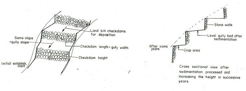
Спецификация (пояснения к техническому рисунку):
Amhara
Technical knowledge required for field staff / advisors: high
Technical knowledge required for land users: moderate
Main technical functions: increase / maintain water stored in soil, sediment retention / trapping, sediment harvesting
Secondary technical functions: reduction of slope angle, reduction of slope length, increase of infiltration
Mixed cropping / intercropping
Material/ species: sorghum/maize +haricot beans
Quantity/ density: 70,000 sor
Remarks: broadcast
Agronomic measure: mixed cropping / intercropping
Material/ species: teff + sunflower
Quantity/ density: -
Remarks: broadcast
Manure / compost / residues
Material/ species: Animal dung, fuelwood ash, leaves, soil
Quantity/ density: 0.6 ton/ha
Contour tillage
Remarks: along contour
Agronomic measure: Sediment trapped by checkdam
Remarks: along the contour
Agronomic measure: Seedbed preparation by hoe
Aligned: -contour
Vegetative material: T : trees / shrubs
Number of plants per (ha): 1500
Vertical interval between rows / strips / blocks (m): 1-1.8m
Spacing between rows / strips / blocks (m): 8-10m
Vertical interval within rows / strips / blocks (m): 1-2m
Width within rows / strips / blocks (m): 1x1
Vegetative measure: aligned: contour
Vegetative material: G : grass
Number of plants per (ha): -
Vertical interval between rows / strips / blocks (m): 1-1.8m
Spacing between rows / strips / blocks (m): 8-10m
Vertical interval within rows / strips / blocks (m): -
Width within rows / strips / blocks (m): -
Vegetative measure: aligned: contour
Vegetative material: G : grass
Number of plants per (ha): 2000
Vertical interval between rows / strips / blocks (m): 1-1.8m
Spacing between rows / strips / blocks (m): 8-10m
Vertical interval within rows / strips / blocks (m): -
Width within rows / strips / blocks (m): -
Vegetative measure: Vegetative material: G : grass
Vegetative measure: Vegetative material: G : grass
Trees/ shrubs species: acacia, eucalyptus, khata edulis, ageava sisal
Fruit trees / shrubs species: coffee, papaya, guava, banana, lemon, manago, orange
Grass species: elephant grass, local grass
Slope (which determines the spacing indicated above): 12.00%
If the original slope has changed as a result of the Technology, the slope today is (see figure below): 3.00%
Gradient along the rows / strips: 0.00%
Structural measure: Checkdam
Vertical interval between structures (m): 1
Spacing between structures (m): 8m
Depth of ditches/pits/dams (m): 0.3m
Width of ditches/pits/dams (m): 1m
Length of ditches/pits/dams (m): 5m
Height of bunds/banks/others (m): 0.5-1m
Width of bunds/banks/others (m): 1m
Length of bunds/banks/others (m): 5.m
Construction material (earth): Soil is embnked upslope of the stone wall as reinforcement
Construction material (stone): Stone is used to construct the embankment/wall/and is supported by soil in the upslope side to reinf
Construction material (wood): Wood used as support at the downslope side
Slope (which determines the spacing indicated above): 12%
If the original slope has changed as a result of the Technology, the slope today is: 3%
Lateral gradient along the structure: 0%
For water harvesting: the ratio between the area where the harvested water is applied and the total area from which water is collected is: 1:3
Vegetation is used for stabilisation of structures.
Change of land use type: gully converted to cropland
Other type of management: fencing and guarding - protect animals from interering to plantations
4.2 Общая информация по необходимым вложениям и стоимости
другая/ национальная валюта (название):
Birr
Если это необходимо, укажите обменный курс от доллара США к местной валюте (например, 1 доллар США = 79,9 бразильского реала): 1 доллар США =:
8,6
Укажите среднюю дневную заработную плату наемных работников:
0.70
4.3 Мероприятия, необходимые для начала реализации
| Деятельность | Время (сессия) | |
|---|---|---|
| 1. | Seedling production | March to June |
| 2. | Planting | June to July |
| 3. | Excavation | dry season |
| 4. | Stone collection | dry season |
| 5. | Construction | dry season |
| 6. | Fencing | after plantation |
4.4 Вложения и затраты, необходимые для начала реализации
| Опишите затраты | Единица | Количество | Затраты на единицу | Общая стоимость на единицу | % затрат, оплаченных землепользователями | |
|---|---|---|---|---|---|---|
| Оплата труда | Labour | ha | 1,0 | 4625,0 | 4625,0 | 90,0 |
| Оборудование | Tools | ha | 1,0 | 120,0 | 120,0 | 95,0 |
| Строительные материалы | Stone | ha | 1,0 | 100,0 | ||
| Общая стоимость запуска Технологии | 4745,0 | |||||
| Общие затраты на создание Технологии в долларах США | 551,74 | |||||
Пояснения:
Duration of establishment phase: 180 month(s)
4.5 Поддержание/ текущее обслуживание
| Деятельность | Сроки/ повторяемость проведения | |
|---|---|---|
| 1. | clean crop residue | Early January / |
| 2. | primary digging | Feb-March / |
| 3. | harrowing | March / |
| 4. | manure application | March / |
| 5. | planting | April / |
| 6. | weeding and cultivation | Late June-August / |
| 7. | harvest | November-December / |
| 8. | replanting | during rains /once a year |
| 9. | pruning and thining | dry season /once a year |
| 10. | Stone collection | dry season/once a year |
| 11. | Placing the stones where maintenance is required | dry season/once a year |
| 12. | repairing breaks in fences | before replanting / annual |
4.6 Стоимость поддержания/ текущего обслуживания ( в год)
| Опишите затраты | Единица | Количество | Затраты на единицу | Общая стоимость на единицу | % затрат, оплаченных землепользователями | |
|---|---|---|---|---|---|---|
| Оплата труда | Labour | ha | 1,0 | 624,0 | 624,0 | 100,0 |
| Оборудование | Tools | ha | 1,0 | 30,0 | 30,0 | 100,0 |
| Строительные материалы | Stone | ha | 1,0 | 100,0 | ||
| Общая стоимость поддержания Технологии | 654,0 | |||||
| Общие затраты на поддержание Технологии в долларах США | 76,05 | |||||
Пояснения:
Machinery/ tools: Shovel, hoe
Length per hectar of land
4.7 Наиболее значимые факторы, влияющие на стоимость затрат
Опишите наиболее значимые факторы, влияющие на стоимость затрат:
labour, slope and depth of the gully, width of the gully, availability of construction material, soil depth. The establishment cost considerts the cost incurred over 15 years.
5. Природные и социально-экономические условия
5.1 Климат
Среднегодовое количество осадков
- < 250 мм
- 251-500 мм
- 501-750 мм
- 751-1000 мм
- 1001-1500 мм
- 1501-2000 мм
- 2001-3000 мм
- 3001-4000 мм
- > 4000 мм
Пояснения/ комментарии по осадкам:
Specification 500-750 mm (600mm)
Specification 750-1000 mm (900mm)
Агроклиматическая зона
- Умеренно-влажная
- полузасушливая
Semi-arid: In the SWC area the semiarid part is about 70%
Sub-humid: Comprises about 30%
5.2 Рельеф
Склоны (преобладающие):
- пологие (0-2%)
- покатые (3-5%)
- покато-крутые (6-10%)
- крутые (11-15%)
- очень крутые (16-30%)
- чрезвычайно крутые (31-60%)
- обрывистые (>60%)
Формы рельефа:
- плато/ равнины
- гребни хребтов/холмов
- склоны гор
- склоны холмов
- подножья
- днища долин
Зона высотной поясности:
- 0-100 м над уровнем моря
- 101-500 м н.у.м.
- 501-1000 м н.у.м.
- 1001-1500 м н.у.м.
- 1501-2000 м н.у.м.
- 2001-2500 м н.у.м.
- 2501-3000 м н.у.м.
- 3001-4000 м н.у.м.
- > 4 тыс. м н.у.м.
Комментарии и дополнительные сведения по условиям рельефа/ топографии :
Landforms: Hill slopes (ranked 1, relatively drier and the technology is most suitable to this area) and ridges (ranked 2, the ridge separates the east and west parts the SWC area)
Slopes on average: Hilly (ranked 1, mostly terraced of stone bunds), rolling (ranked 2, more number of gullies and more area under the technology) and steep (ranked 3, bush lands suitable for grazing)
5.3 Почвы
Средняя мощность почв:
- поверхностные (0-20 см)
- неглубокие (21-50 см)
- умеренно глубокие (51-80 см)
- глубокие (81-120 см)
- очень глубокие (> 120 см)
Гранулометрический состав (верхнего горизонта):
- грубый крупнозернистый/ лёгкий (песчаный)
- средние фракции (суглинистый, супесчаный)
Содержание органического вещества в верхнем горизонте:
- низкое (< 1%)
Если возможно, приложите полное описание почв или укажите доступную информацию, например тип почв, рH/ кислотность почв, ёмкость катионного обмена, содержание азота, содержание солей и т.д.
Soil depth on average: Shallow (ranked1, more on hill slopes), moderately deep (ranked 2, on rolling terrain) and very shallow (ranked 3, on hilly and steep slopes)
Soil texture: Medium (dominant on hilly slopes) and coarse/light (on rolling terrains)
Soil fertility is low (on hilly sloping areas) and medium (on rolling lands)
Topsoil organic matter: Low (in all land forms)
Soil drainage/infiltration is good (on hilly and rolling lands) and medium (ridge)
Soil water storage capacity is low (on hilly and rolling lands) and medium (ridge)
5.6 Характеристика землепользователей, применяющих Технологию
Рыночная ориентация производства:
- натуральное хозяйство (самообеспечение)
- смешанный (натуральный / коммерческий)
Доходы из других источников:
- < 10% всех доходов
Относительный уровень достатка:
- плохой
- средний
Уровень механизации:
- ручной труд
- тягловая сила
Укажите другие важные характеристики землепользователей:
Population density: 50-100 persons/km2
Annual population growth: 2% - 3%
20% of the land users are rich and own 30% of the land.
35% of the land users are average wealthy and own 30% of the land.
45% of the land users are poor and own 40% of the land.
Market orientation of garzing land production system: Subsistence (self-supply, production ids for self consumption and even it does not satistfy household needs)
Market orientation of crop land production system: Subsistence (self-supply) and mixed (subsistence and commercial)
Market orientation of crop land production system: Subsistence (self-supply, fuel wood collection for home consumption , construction wood, sell fuel woo and , make charcoal )
5.7 Средняя площадь земель, используемых землепользователями с применением Технологии
- < 0,5 га
- 0,5-1 га
- 1-2 га
- 2-5 га
- 5-15 га
- 15-50 га
- 50-100 га
- 100-500 га
- 500-1000 га
- 1000-10000 га
- > 10000 га
5.8 Собственность на землю, права на земле- и водопользование
Землевладелец:
- государственная
Право землепользования:
- индивидуальное
6. Воздействия и заключительные положения
6.1 Влияние Технологии УЗП в пределах территории ее применения
Социально-экономическое воздействие
Продуктивность
производство сельскозяйственных культур
Комментарий/ пояснения:
The cost benefit anlysis for sorghum shows negative profit but for other crops such as combination of coffe, papaya, chat the profit is high
производство кормов
качество кормов
Доходы и затраты
доходы хозяйства
Комментарий/ пояснения:
for cropping patterns which consider field crops + cash crops is high
Социальное и культурное воздействие
знания в области УЗП/ деградации земель
Экологическое воздействие
Водный цикл/ поверхностный сток
поверхностный сток
Количество до применения УЗП :
70
Количество после применения УЗП:
5
Почвы
влажность почв
Комментарий/ пояснения:
soil depth increased by depostion infiltration enhanced
почвенный покров
Комментарий/ пояснения:
plantations
утрата почв
Количество до применения УЗП :
10
Количество после применения УЗП:
0
Комментарий/ пояснения:
checdams decrease gully slope
Другие экологические последствия
Soil fertility
Комментарий/ пояснения:
Fertile top soil erdoed upslope is trapped in the gully
Biodiversity
Комментарий/ пояснения:
combined application of useful plants and crop
6.2 Влияние Технологии за пределами территории ее применения
надежность и постоянство водотоков
Комментарий/ пояснения:
high percolation rate of rain water
подтопление ниже по течению
Комментарий/ пояснения:
runoff is trapped by supportive technologies undertaken in the upper catchment and runoof velocity retarded by checkdams
отложение наносов ниже по течению
Комментарий/ пояснения:
sediment trapped in the gullies
6.4 Анализ эффективности затрат
Насколько получаемый результат сопоставим с первоначальными вложениями (с точки зрения землепользователей)?
Эффективность затрат в краткосрочной перспективе:
отрицательно
Эффективность затрат в долгосрочной перспективе:
позитивное
Насколько получаемый результат сопоставим с текущими расходами по поддержанию технологии (с точки зрения землепользователей)?
Эффективность затрат в краткосрочной перспективе:
слабо отрицательное
Эффективность затрат в долгосрочной перспективе:
позитивное
6.5 Внедрение Технологии
Если возможно, дайте количественную характеристику (число домохозяйств и/или площадь применения):
25000
Среди применяющих Технологию землепользователей, какова доля лиц, применяющих её по собственной инициативе, т.е. без какого-либо материального стимулирования со стороны?
- 91-100%
Пояснения:
25000 land user families have adopted the Technology with external material support
Comments on acceptance with external material support: estimates
100% of land user families have adopted the Technology without any external material support
25000 land user families have adopted the Technology without any external material support
Comments on spontaneous adoption: estimates
There is a little trend towards spontaneous adoption of the Technology
Comments on adoption trend: Reclaiming gullies for agricultural land (crop and livestock production) is labourous.
6.7 Сильные стороны/ преимущества/ возможности Технологии
| Сильные стороны/ преимущества/ возможности по мнению землепользователей |
|---|
|
Land reclaimed How can they be sustained / enhanced? fertility of soils increased by accumulated top soil from other area. |
|
retain moisture How can they be sustained / enhanced? water stored in the soil. |
| Сильные стороны/ преимущества/ возможности по мнению составителя или других ключевых специалистов |
|---|
|
Reduce runoff speed How can they be sustained / enhanced? exercise frequent maintenance and stablize the structure with vegetative measures |
|
Reduce soil loss How can they be sustained / enhanced? soil is trapped by the checkdam |
|
Moisture retention How can they be sustained / enhanced? the soil trapped provides more space for water to be stored. |
|
reduce slope length How can they be sustained / enhanced? by raising the gully bed. |
7. Справочные материалы и ссылки
7.1 Методы сбора/ источники информации
7.2 Ссылки на опубликованные материалы
Название, автор, год публикации, ISBN:
Monthly, quarterly and annual achievement reports of the DWARDO
Название, автор, год публикации, ISBN:
Work norm of MERET
Название, автор, год публикации, ISBN:
Ethiopian Highlands Reclamation stdy
Название, автор, год публикации, ISBN:
Soil and water conservation , Morgan 1986
Ссылки и модули
Развернуть все Свернуть всеСсылки
Нет ссылок
Модули
Нет модулей