Stone Check Walls and Check Dams for Soil and Water Conservation [Индия]
- Создание:
- Обновить:
- Составитель: Jaclyn Bandy
- Редактор: –
- Рецензент: Hanspeter Liniger
technologies_5210 - Индия
Просмотреть разделы
Развернуть все Свернуть все1. Общая информация
1.2 Контактные данные специалистов и организаций, участвующих в описании и оценке Технологии
Ответственный (-ые) специалист (-ы)
землепользователь:
Jagdamba Joshi
Nakina Village
Индия
Название проекта, содействовавшего документированию/оценке Технологии (если применимо)
Onsite and Offsite Benefits of SLMНазвание организации (-ий), содействовавших документированию/оценке Технологии (если применимо)
ICIMOD International Centre for Integrated Mountain Development (ICIMOD) - НепалНазвание организации (-ий), содействовавших документированию/оценке Технологии (если применимо)
G.B. Pant Institute of Himalayan Einvironment & Development (G.B. Pant Institute of Himalayan Einvironment & Development) - Индия1.3 Условия, регламентирующие использование данных, собранных ВОКАТ
Составитель и ответственный(-ые) специалист(-ы) согласны с условиями, регламентирующими использование собранных ВОКАТ данных:
Да
1.4 Декларация по устойчивости описываемой Технологии
Вызывает ли описанная здесь Технология проблемы деградации земель настолько, что ее нельзя назвать природосберегающей?
Нет
1.5 Ссылка на Анкету (ы) по Подходам УЗП (документируется с использованием ВОКАТ)

Community Forest Management in the Nakina Van Panchayat [Индия]
Van Panchayats or village forest councils are a impressive example of grassroots community management of natural resources, where a specific administrative unit is locally elected by community members who are responsible for the management of activities related to the forest.
- Составитель: Jaclyn Bandy
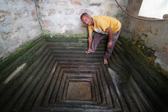
Naula Management and Conservation [Индия]
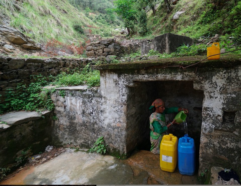
Naulas are shallow, four-sided stepped wells designed to collect water from subterranean seepages or springs and are used to meet domestic water needs by the local communities. Naula management and conservation encompasses a range of activities that preserve their structure and function.
- Составитель: Jaclyn Bandy
2. Описание Технологии УЗП
2.1 Краткое описание Технологии
Определение Технологии:
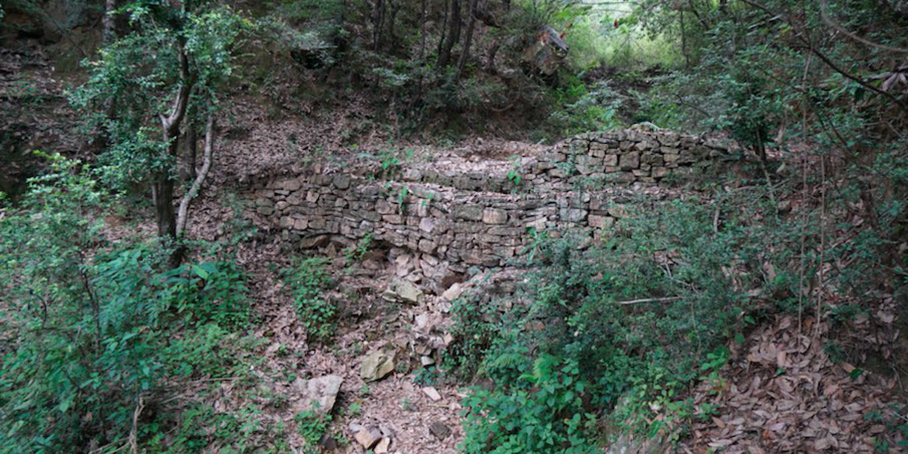
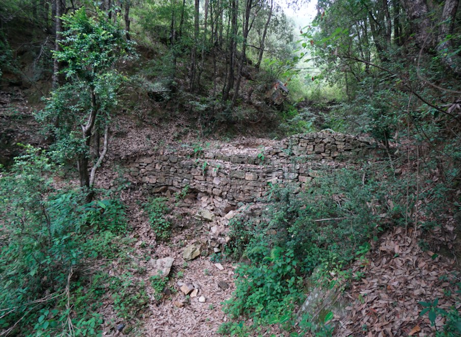
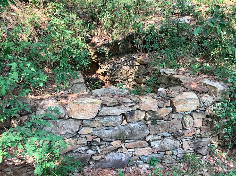
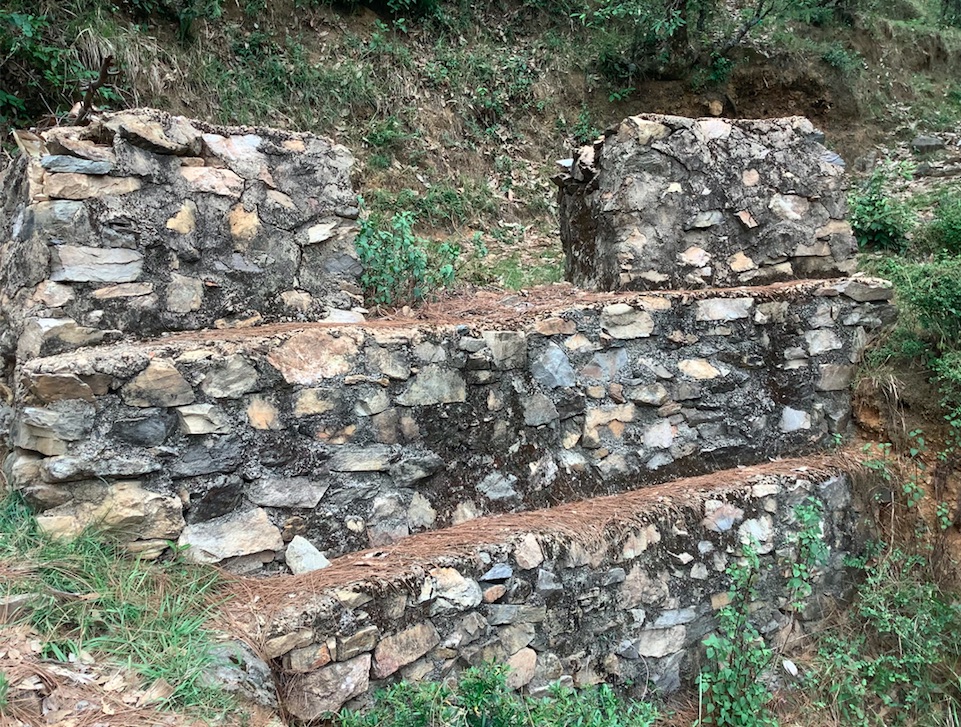
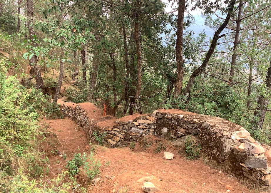
Stone Check Dams/Walls, Retainment Walls, and a Water Diversion Wall has been constructed in Nakina Village and Nakina Community Forest to help protect their settlements, agriculture land, forest land, and preserve the hilly landscape. These structures serve to reduce the runoff velocity (lowering the rate of erosion and gullying in steep slope channels) and increase infiltration for groundwater recharge.
2.2 Подробное описание Технологии
Описание:
1. The technology is found in both natural and human environments (forest and settlement areas)
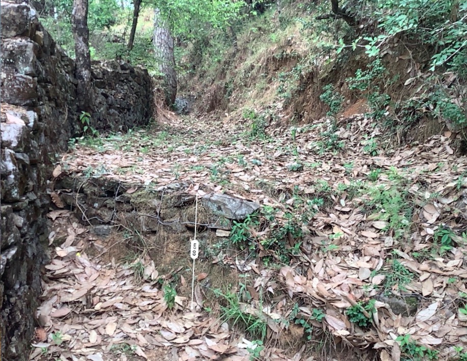
2. Main Characteristics: A check dam or check wall is constructed in a loose or active gully or a rill (shallow channel) that threatens to enlarge, or anywhere on a slope where there is a danger of scour from running water. The structures lower the velocity of flow. In Nakina porous check walls, check dams, and retainment walls were made out of stone gathered from the surrounding area. A porous check dam releases a portion of flow through the structure, decreases the head of flow over the spillway, and decreases the dynamic and hydrostatic forces against the check dam. Porous check dams are simple and more economical for construction.
Once stones are collected they are cut into suitable sizes and surfaces ( "dressing" of stones). The site where the technology is to be constructed is then cleared and, for check dams, the sides are sloped 1:1 (this simply refers to the ratio of the rise and run of the slope, so 1:1 means you'll have a 45 degree slope for your excavation). This is also known as the angle of repose, where the granular material of the embankment will be stable and not slump from its own weight. The base of the dam should be around 70 cm thick if it is 1 meter high. The bed of gully is excavated for foundation and dry stones are packed from that level.
3. Purposes/functions: Interrupts the flow of water and flattens the gradient of a channel, thereby reducing the velocity and inducing infiltration rather than eroding the channel. These structures not only slow flow velocity but also to distribute flows across vegetation. Despite some sedimentation resulting behind the dam, small cracks and porous spaces in the holes of the stones allow some sediment to flow through and the finer particles fill the gaps and strengthen the structure. Check dams can also be designed to create small reservoirs.
4. Major activities include identifying the appropriate site of installation, collection of construction materials, technical planning of the structure dimensions and design, manual labor, and maintenance.
5. Benefits/impacts: These structures decelerate runoff and accelerates groundwater recharging by storing water and facilitating infiltration of water into the soil
6. Like/Dislike:
Advantages
•Inexpensive and relatively easy to install given local building materials and labor availability
•Reduce velocity, prevent gully erosion and cause a high proportion of the sediment load in runoff to settle out, preventing downstream damage
•When carefully located and designed, check dams can remain as permanent installations with very minor regrading
Disadvantages
•Many of these structures have a temporary nature, and need to reconstructed or removed after significant damage
•Removal or reconstruction may be a significant cost depending on the size and design
•May kill grass linings in channels if the water level remains high after rainstorms or if there is significant sedimentation.
•May create turbulence which erodes the channel banks.
•Clogging by organic material may be a problem and hinder the structure's function
2.3 Фотографии, иллюстрирующие Технологию
Медиа-галерея
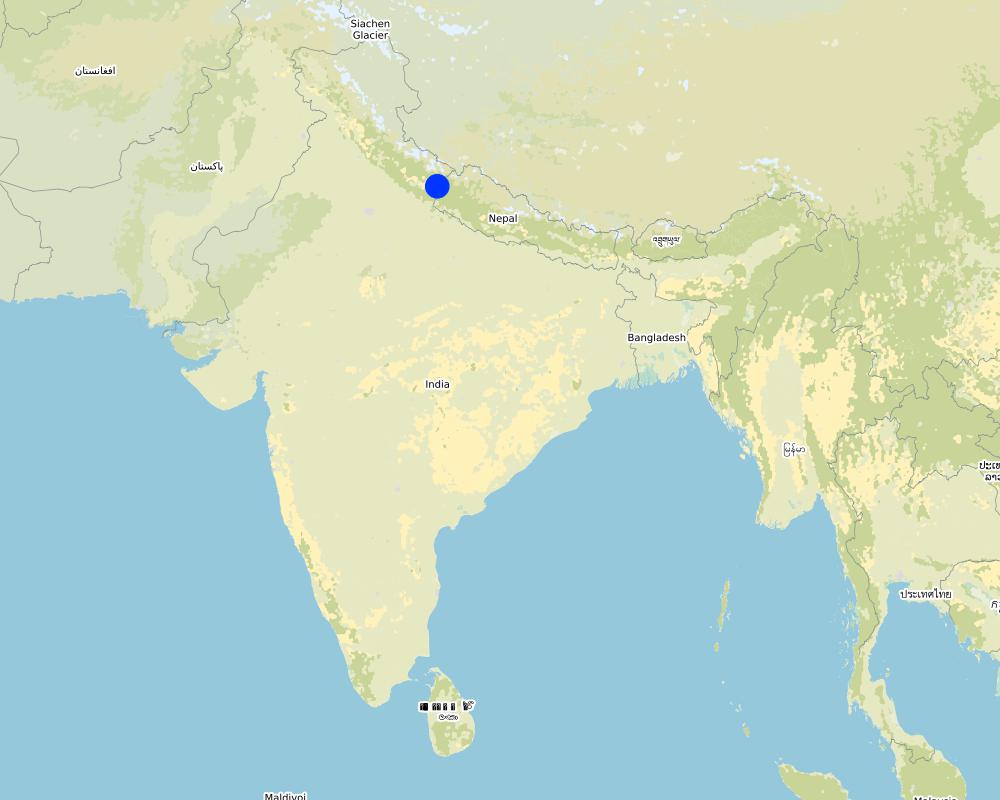
2.5 Страна/ регион/ места, где применяется Технология, информация о которых собрана в данной Анкете
Страна:
Индия
Административная единица (Район/Область):
Uttarakhand
Более точная привязка места:
Nakina Village, Pithoragarh Bloc
Охарактеризуйте пространственное распространение Технологии :
- примененяется точечно/ на небольших участках
Технология применяется на ООПТ?
Да
Если да, укажите:
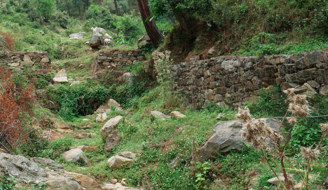
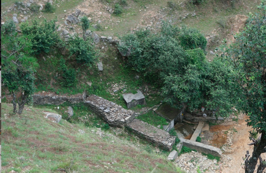
5 check dams are located in the protected forest of Nakina. The other structures are located in the village settlement (the 5 check walls are within the ravine) or just above the Bhind Spring (Naula).
Map
×2.6 Сколько лет применяется данная Технология
Если год начала применения Технологии достоверно неизвестен, дайте примерную оценку:
- более 50 лет назад (традиционная)
2.7 Внедрение Технологии
Укажите, как именно Технология УЗП была внедрена:
- как инновация (инициатива) землепользователей
- как часть традиционной системы землепользования (более 50 лет назад)
- через проекты/ внешнее вмешательство
Пояснения (тип проекта и т.д.):
Check dams and other retainment structures are technologies that have been used for centuries. Some of the structures in the village are nearly +50 years old and have either been constructed with the help of the government (ravine check dams in settlement and above Bhind Naula) and others have been more recently constructed by the villagers themselves to support the forest landscape, specifically springshed recharge.
3. Классификация Технологии УЗП
3.1 Основные цели и задачи реализации Технологии
- снижение или предотвращение деградации земель, восстановление нарушенных земель
- сохранение экосистем
- защита бассейнов рек (приводораздельной части/ нижнего течения) – в сочетании с другими Технологиями
- снижение риска стихийных бедствий
- адаптация к изменению климата / экстремальным погодным явлениям и их последствиям
3.2 Текущий(-ие) тип(-ы) землепользования на территории, где применяется Технология

Леса/ лесистая местность
- (Квази-) Природные леса/ лесные массивы
(Квази-) Природные леса / лесные массивы: Укажите тип управления:
- Выборочные рубки
Тип (полу-) естественного леса:
- естественная субтропическая сухая лесная растительность
- quercus leucotrichophora (Banj oak)
Являются ли указанные выше деревья лиственными или вечнозелеными?
- лиственные
Продукции и услуги:
- Древесина
- Дрова
- Выпас/ ощипывание молодых побегов и листьев
- Природоохранные/ защитные

Населенные пункты, инфраструктура
- Жилищная застройка, другие здания
3.3 Изменилось ли использование земель в связи с внедрением Технологии?
Изменилось ли использование земель в связи с внедрением Технологии?
- Нет (см. пункт 3.4)
3.4 Водоснабжение
Обеспеченность водой участков, где реализуется Технология :
- богарные земли
3.5 Категория УЗП, к которой относится Технология
- мероприятия по влагозадержанию и снижению эрозии почв на склонах
- Водоотвод и осушение
- управление поверхностными водами (родники, реки, озёра, моря)
3.6 Мероприятия УЗП, выполняемые в рамках Технологии

инженерные мероприятия
- И3: Ступенчатые канавы (арыки), каналы, водотоки
- И6: Стенки, барьеры, заборы, изгороди
3.7 Основные проблемы деградации земель, на решение которых направлена Технология

водная эрозия почв
- ВЭп: поверхностная эрозия/смыв верхних почвенных горизонтов
- ВЭл: овражная эрозия / оврагообразование
- ВЭо: гравитационное перемещение горных пород / оползни
- ВЭрб: эрозия речных берегов
- ВЭд: косвенное воздействие водной эрозии

ухудшение физических свойств почв
- Фп: сработка органических горизонтов почв, оседание поверхности

биологическая деградация
- Бр: сокращение растительного покрова
- Бк: сокращение количества биомассы

деградация водных ресурсов
- Вуг: изменения уровня грунтовых вод/ водоносных горизонтов
3.8 Предотвращение и снижение деградации земель, или восстановление нарушенных земель
Укажите цель Технологии по отношению к деградации земель :
- предотвращение деградации земель
- снижение деградации земель
4. Технические характеристики, мероприятия по практической реализации, вложения и стоимость
4.1 Технический рисунок, иллюстрирующий Технологию
Автор:
Jaclyn Bandy
Дата:
02/08/2019
Автор:
Jaclyn Bandy
Дата:
02/08/2019
Автор:
Jaclyn Bandy
Дата:
02/08/2019
Автор:
Jaclyn Bandy
Дата:
02/08/2019
4.2 Общая информация по необходимым вложениям и стоимости
Уточните, как рассчитывались затраты и вложения:
- на технологическую единицу
Укажите единицу:
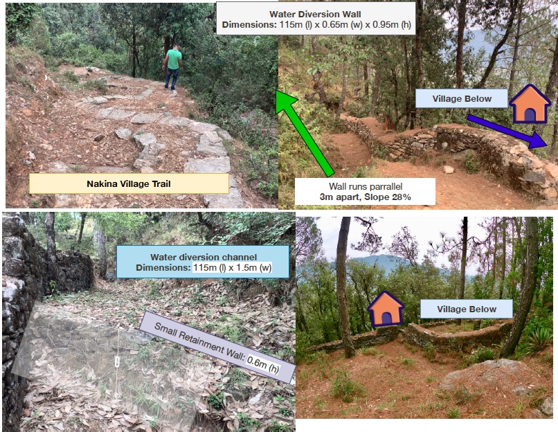
1. Small Check Dams 2. Large Check Walls 3. Water Diversion Wall 4. Bhind Check Walls/Retainment wall
Укажите единицы измерения (если необходимо):
1. 5 units (3.5m x 1.5m x 0.9m) 2. 5 units (8m x 1m x 2.7m) 3. 1 unit (115m x 0.65 x 0.95m) 4. 1 unit (100m x 1m x 1.5m)
другая/ национальная валюта (название):
INR
Если это необходимо, укажите обменный курс от доллара США к местной валюте (например, 1 доллар США = 79,9 бразильского реала): 1 доллар США =:
70,0
Укажите среднюю дневную заработную плату наемных работников:
400 INR per head/day
4.3 Мероприятия, необходимые для начала реализации
| Деятельность | Время (сессия) | |
|---|---|---|
| 1. | Nakina village built a long water diversion wall over +50 years ago that serves as a water channel, directing runoff away from settlements and towards the ravine | Pre-monsoon /dry season |
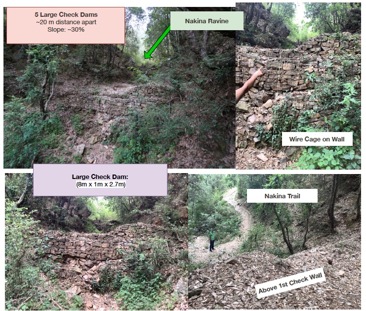
| 2. | Within the ravine/gully in Nakina Village, there is a series of 5 large check walls that were established with the help of the Forest Department | Pre-monsoon /dry season |
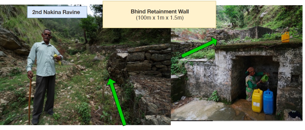
| 3. | There is a series of check walls/check dams in another gully that were established in 1952 above the Bhind Spring/Naula (on the opposite side of the village) to protect it and decrease runoff/further erosion | Pre-monsoon/dry season |
| 4. | In December 2017 the Nakina Van Panchayat (community forest council) decided to construct 5 new check dams within the Nakina Forest, which lie in the upper catchment area of the Bhind Spring | Pre-monsoon/dry season |
| 5. | For the establishment of all these structures, the community and technical assistants assessed the topography of the area, size of the gully, catchment area and runoff rate before establishing the check-dam. | Pre-monsoon/dry season |
| 6. | The sites were selected and prepared by removing debris and other unsuitable material which would interfere with proper placement of the check dam/wall materials. | Pre-monsoon/dry season |
4.4 Вложения и затраты, необходимые для начала реализации
| Опишите затраты | Единица | Количество | Затраты на единицу | Общая стоимость на единицу | % затрат, оплаченных землепользователями | |
|---|---|---|---|---|---|---|
| Оплата труда | Large Water Diversion Wall | person-days | 60,0 | 400,0 | 24000,0 | 20,0 |
| Оплата труда | 5 Large Check Walls | person-days | 50,0 | 400,0 | 20000,0 | 20,0 |
| Оплата труда | Bhind Spring Check Walls/Retainment Wall | person-days | 19,0 | 400,0 | 7600,0 | 50,0 |
| Оплата труда | 5 Small Check Walls in Forest | person-days | 10,0 | 400,0 | 4000,0 | 100,0 |
| Оборудование | Crate Wire (15m x 2m x 2m) | Cum | 60,0 | 75,0 | 4500,0 | |
| Оборудование | Pick | pieces | 15,0 | 300,0 | 4500,0 | 100,0 |
| Оборудование | Shovel | pieces | 20,0 | 500,0 | 10000,0 | 100,0 |
| Оборудование | pharuwa (hoe) | pieces | 15,0 | 300,0 | 4500,0 | 100,0 |
| Оборудование | khanti (digging bar) | pieces | 10,0 | 1500,0 | 15000,0 | 100,0 |
| Оборудование | hammer (5kg) | pieces | 10,0 | 2000,0 | 20000,0 | 100,0 |
| Оборудование | chino (chisel) | pieces | 10,0 | 500,0 | 5000,0 | 100,0 |
| Оборудование | khukuri (knife) | pieces | 10,0 | 250,0 | 2500,0 | 100,0 |
| Посадочный материал | small hammer (0.5-1 kg) | pieces | 15,0 | 300,0 | 4500,0 | 100,0 |
| Строительные материалы | Rocks of various size and shape collected/excavated on site | |||||
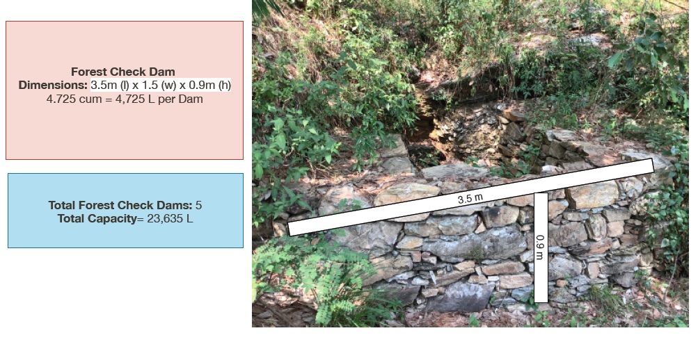
| Строительные материалы | Small Check Walls in Forest (5) | cum | 23,625 | 200,0 | 4725,0 | 100,0 |
| Строительные материалы | Large Check Walls (5) | cum | 108,0 | 200,0 | 21600,0 | 20,0 |
| Строительные материалы | Large Water Diversion Wall (1) | cum | 71,0 | 200,0 | 14200,0 | 100,0 |
| Строительные материалы | Bhind Check Walls/Retainment Wall (5) | cum | 150,0 | 200,0 | 30000,0 | 50,0 |
| Другие | Rocks of various size and shape collected/excavated on site | |||||
| Общая стоимость запуска Технологии | 196625,0 | |||||
| Общие затраты на создание Технологии в долларах США | 2808,93 | |||||
Если землепользователем оплачено менее 100% затрат, укажите, кем покрывались остальные затраты:
Uttarakhand Forest Department (Government), JICA (Japan International Cooperation Agency)
Пояснения:
Cost Estimate: 200 INR/cum
Example:
1. Small Check Dams: 5 units (3.5m x 1.5m x 0.9m) ----- 4.725 cum x 200 INR = 945 INR/unit
945 INR/unit x 5 units = 4,725 Rs
or...
(4.725 cum/unit x 5 unit = 23.625 total cum )
(23.625 total cum x 200 INR = 4,725 Rs.)
2. Large Check Walls: 5 units (8m x 1m x 2.7m) -----21.6 x 200 = 4320
4320 cum x 5 units = 21,600 Rs
3. Water Diversion Wall: 1 unit (115m x 0.65 x 0.95m) ------71 x 200= 14,200
14,200 X 1 unit= 14,200 Rs
3. Bhind Spring Check Walls/Retainment Wall: 1 unit (100m x 1m x 1.5m) = 150 total cum
150 x 200 INR = 30,000 INR Total
4.5 Поддержание/ текущее обслуживание
| Деятельность | Сроки/ повторяемость проведения | |
|---|---|---|
| 1. | Inspection of the check dam for rock displacement and erosion around the ends of the dam after each significant rainfall event | Monsoon/ weekly |
| 2. | Sediment accumulation is removed if it reaches a depth of ½ the original dam height | Pre-monsoon/Monsoon |
| 3. | Sometimes check dams are removed when their useful life is completed | Annual inspections |
4.6 Стоимость поддержания/ текущего обслуживания ( в год)
| Опишите затраты | Единица | Количество | Затраты на единицу | Общая стоимость на единицу | % затрат, оплаченных землепользователями | |
|---|---|---|---|---|---|---|
| Оплата труда | Reconstruction of damaged check dams | person-days/unit | 10,0 | 400,0 | 4000,0 | 100,0 |
| Оплата труда | Removal of sediment | person-days/unit | 5,0 | 400,0 | 2000,0 | 100,0 |
| Оборудование | pick | pieces | 3,0 | 70,0 | 210,0 | 100,0 |
| Оборудование | shovel | pieces | 3,0 | 42,0 | 126,0 | 100,0 |
| Оборудование | pharuwa (hoe) | pieces | 2,0 | 52,0 | 104,0 | 100,0 |
| Оборудование | khanti (digging bar) | pieces | 2,0 | 30,0 | 60,0 | 100,0 |
| Оборудование | hammer | pieces | 3,0 | 25,0 | 75,0 | 100,0 |
| Оборудование | chino (chisel) | pieces | 2,0 | 75,0 | 150,0 | 100,0 |
| Оборудование | khukuri (knife) | pieces | 2,0 | 22,0 | 44,0 | 100,0 |
| Оборудование | small hammer (0.5-1kg) | pieces | 3,0 | 120,0 | 360,0 | 100,0 |
| Строительные материалы | Stones available at site locally | |||||
| Общая стоимость поддержания Технологии | 7129,0 | |||||
| Общие затраты на поддержание Технологии в долларах США | 101,84 | |||||
4.7 Наиболее значимые факторы, влияющие на стоимость затрат
Опишите наиболее значимые факторы, влияющие на стоимость затрат:
Size of the check dam/check wall
Frequency and intensity of the damage to the structures
Labor availability
5. Природные и социально-экономические условия
5.1 Климат
Среднегодовое количество осадков
- < 250 мм
- 251-500 мм
- 501-750 мм
- 751-1000 мм
- 1001-1500 мм
- 1501-2000 мм
- 2001-3000 мм
- 3001-4000 мм
- > 4000 мм
Укажите среднегодовое количество осадков (если известно), мм:
1500,00
Пояснения/ комментарии по осадкам:
Monsoon- mid-June to mid-September; July and August are the rainiest months and the temperature is warm and moist; between 70-85% of the annual precipitation occurs in the monsoon season
Seasons
a. Winter or Cold weather (mid Dec. - mid March)
b. Summer or hot weather (mid March - mid June)
c. Season of general rains (South - West monsoon season)
d. Season of retreating monsoon (mid September to mid November)
Укажите название соответствующей метеостанции:
India Meteorological Department, Meteorological Centre Dehradun
Агроклиматическая зона
- Умеренно-влажная
The overall climatic condition in the Pithoragarh district is governed by the southwest monsoon. It has a sub-tropical to temperate climate, with three pronounced seasons; summer, winter, and monsoon. The hilly terrain of the Himalayan region has snow cover and is cold during winter with snowfall normally occurring during the months of December to March.
Temperature- The temperature ranges from 0°C to 10°C in winter and from 8°C to 33°C in summer season. However, there is no meteorological observatory in the district. The account of the climate is based mainly on the records of the observations in the neighboring districts where similar meteorological conditions prevail. Variations in temperature are considerable from place to place and depend upon elevation as well as aspect. As the insolation is intense at high altitudes, in summer temperatures are considerably higher in the open than in the shade.
5.2 Рельеф
Склоны (преобладающие):
- пологие (0-2%)
- покатые (3-5%)
- покато-крутые (6-10%)
- крутые (11-15%)
- очень крутые (16-30%)
- чрезвычайно крутые (31-60%)
- обрывистые (>60%)
Формы рельефа:
- плато/ равнины
- гребни хребтов/холмов
- склоны гор
- склоны холмов
- подножья
- днища долин
Зона высотной поясности:
- 0-100 м над уровнем моря
- 101-500 м н.у.м.
- 501-1000 м н.у.м.
- 1001-1500 м н.у.м.
- 1501-2000 м н.у.м.
- 2001-2500 м н.у.м.
- 2501-3000 м н.у.м.
- 3001-4000 м н.у.м.
- > 4 тыс. м н.у.м.
Укажите, приурочено ли применение Технологии к специфическим условиям:
- в ситуациях вогнутого рельефа
Комментарии и дополнительные сведения по условиям рельефа/ топографии :
Altitude of evaluated sites: 1800-1990m
Average Slope: 25-+30%
5.3 Почвы
Средняя мощность почв:
- поверхностные (0-20 см)
- неглубокие (21-50 см)
- умеренно глубокие (51-80 см)
- глубокие (81-120 см)
- очень глубокие (> 120 см)
Гранулометрический состав (верхнего горизонта):
- грубый крупнозернистый/ лёгкий (песчаный)
- средние фракции (суглинистый, супесчаный)
Гранулометрический состав (на глубине более 20 см):
- средние фракции (суглинистый, супесчаный)
Содержание органического вещества в верхнем горизонте:
- среднее (1-3%)
- низкое (< 1%)
Если возможно, приложите полное описание почв или укажите доступную информацию, например тип почв, рH/ кислотность почв, ёмкость катионного обмена, содержание азота, содержание солей и т.д.
Mountain/hill soils are a collective name given to various types of soils found under the following conditions :
-under sub-tropical, temperate and sub-alpine conditions
-under various forest types
Characteristics: very thin, fertile, and may be less than a centimeter deep on steep slopes; they are mixed with pebbles, shingles (a mass of small rounded pebbles), and gravels; they have a low-medium water holding capacity. Angular and subangular fragments of parent rock may be found mixed with the lower layers of the mountain and hill soils.
Texture: varies from loamy to sandy loam.
Soil Reaction: ranges from acidic to neutral (pH 4.6 to 6.5)
Organic Matter content: 1-5%
Ferrugenous red roils are found in this district and are well developed over Himalayan rocks (quartzite, biotite schist, amphibolite schist). They are free of carbonates and deficient in nitrogen, humus and phosphorus, light textured, porous, and friable (brittle/crumbly). The soil depth ranges from about 10cm-75 cm. These soils may be grouped into two on basis of morphology
1. Red earths- loose, friable topsoil rich in secondary concretions (hard, compact mass of matter formed by the precipitation of mineral cement within the spaces between particles, and is found in sedimentary rock or soil)
2. Red loam- argillaceous soils having a blocky structure (argillaceous minerals may appear silvery upon optical reflection and are minerals containing substantial amounts of clay-like components, e.g. argillaceous limestones are limestones consisting predominantly of calcium carbonate, but including 10-40% of clay minerals)
Brown soil: is found particularly under dense broadleaved temperate and sub-alpine forests. There occurs a thick layer of humus on the forest floor (made of decomposed leaves, branches, twigs) and the topsoil is extremely rich in humus
Podsolic Soil: soil that has developed in humid/temperate conditions usually under coniferous forests (e.g. deodar, blue pine, fir, spruce) over quartzite, granites, schists and gneiss.
Citation: Kumaun: The Land and the People, Sharad Singh Negi (1993)
5.4 Доступность и качество воды
Уровень грунтовых вод:
> 50 м
Доступность поверхностных вод:
средняя
Качество воды (без обработки):
питьевая вода хорошего качества
Качество воды относится к:
грунтовые воды
Является ли солёность воды проблемой?
Нет
Происходят ли периодические затопления территории?
Нет
Комментарии и дополнительная информация по качеству и количеству воды:
Quantity: Water crisis has been a perennial problem in both the rural and urban areas of the Pithoragarh district
There is scarcity of safe drinking water of the villages in the study area. Hand pumps are often not functioning, pipe-water schemes are unreliable and the spring discharges have reduced during the dry season. Hand-pumped water often has a high iron content and bitter taste. Poor quality of groundwater in some of the naulas is mainly due to misuse and/or disuse of the structures.
A block-district groundwater resource estimation could not be carried out as the area is hilly (with slope >20%) and in major part aquifers are small, isolated bodies, and groundwater abstraction is done mainly through hand pumps and springs with small discharges.
However, we collected some physicochemical parameters that indicate the water (sourced from springs) is of good quality:
Water Quality Parameters of Springs:
pH: 6.29-8.18
Temp: 19.0-23.5 ºC
Electrical Conductivity: 109-504 µmsiemens
Total Dissolved Solids: 75-385 ppm
Other Parameters (from springs of nearby district, Champawat)
Electrical Conductivity: 127-222 µmsiemens
pH: 7.69-8.24
Calcium: 16-36 mg/l
Magnesium: 4.9-7.3 mg/l
Bicarbonate: 61-134 mg/l
Chloride: 5.3- 8.9 mg/l
Total Hardness as CaCO3: 70-110 mg/l
Source: Government of India Ministry of Water Resources, Central Ground Water Board, 2009 Groundwater Brochure of Champawat District (2009)
5.5 Биоразнообразие
Видовое разнообразие:
- средняя
Разнообразие местообитаний:
- средняя
Комментарии и дополнительная информация по биоразнообразию:
Uttarakhand has more than 7000 species of medicinal plants and 500 species of fauna. Floral diversity contributes 31% of total floral density of India. Fauna contributes just 1.58% of the total faunal density of the country. There are 119 endemic species of flowering plants in the state that exhibited 2.35% endemism and 35 faunal endemic species. Because it lies at the juncture of India, Nepal and the Tibeten Autononmous region, there often cases of poaching and smuggling of wildlife contrabands, including bear bile, musk pods and leopard skins through the borders. Yarsa Gumba Ophiocordyceps sinensis, commonly known as Caterpillar Fungus, is also illegally traded transboundary in the region, together with various plant species. Due to anthropogenic impacts, changes is soil quality, and climatic elements, the biodiversity of our study site is not as high as in other areas of the Pithoragarh district.
Citation: Sundriyal, M. & Sharma, B. (2016). Status of Biodiversity in Central Himalaya, Applied Ecology and Environmental Sciences, 4( 2), 37-43.
5.6 Характеристика землепользователей, применяющих Технологию
Осёдлый или кочевой:
- Осёдлый
Рыночная ориентация производства:
- натуральное хозяйство (самообеспечение)
- смешанный (натуральный / коммерческий)
Доходы из других источников:
- 10-50% всех доходов
Относительный уровень достатка:
- плохой
Индивидуальное или коллективное хозяйство:
- группа/ община
Уровень механизации:
- ручной труд
Пол:
- женщины
- мужчины
Возраст землепользователей:
- молодёжь
- средний возраст
- пожилой
Укажите другие важные характеристики землепользователей:
With recent development in Pithoragarh, an influx of funds coming from outside sources has caused a decline in the importance of agriculture production, which in now marginalized, based on female labour, and mainly conducted for subsistence with little surplus to sell. High caste men do not work in cultivation at all, and male tasks such as ploughing are performed by the Scheduled Caste.
Although most women are still cultivating, their work has lost economic importance. For most families, the produce does not cover the needs of the household and surplus must be bought from the market. Many of the terraces that were formerly fruit orchards (mainly citrus) have been completely abandoned. Farming is less intensive and landholdings are small and fragmented. The main crops are wheat, millet, and pulses, but yields are low as the land is not irrigated. Less livestock (cows, goats, buffalo) is kept because of the labor involved. Very little capital is returned to farming. Crops produced for the markets in the plains are replacing traditional crops to sustain the household.
With exposure to the“Modern” lifestyle, new values have also been accepted. Two children are the norm (the ideal being one son and one daughter, but at least one son in a must). Although access to education is quite good, it does not seem to result in working careers for women. The women, both young and old, spend their days with domestic and agriculture work. Several village persons stated that it would be best to educate their daughters so they could get a government job.
5.7 Средняя площадь земель, используемых землепользователями с применением Технологии
- < 0,5 га
- 0,5-1 га
- 1-2 га
- 2-5 га
- 5-15 га
- 15-50 га
- 50-100 га
- 100-500 га
- 500-1000 га
- 1000-10000 га
- > 10000 га
Считается ли это мелким, средним или крупным хозяйством (по местным масштабам)?
- мелкое
5.8 Собственность на землю, права на земле- и водопользование
Землевладелец:
- общинная/ поселковая
Право землепользования:
- общинное (контролируемое)
Право водопользования:
- неограниченное (неконтролируемое)
- общинное (контролируемое)
Права на землепользование основаны на традиционной правовой системе?
Да
Поясните:
Under the Kumaun Panchayat forest rules of 1931 (amended in 1976): A Van Panchayat, (community forest council), can be formed out of non-private land within the settlement boundaries of a village. Accordingly, all villagers are members of the VP upon their approval by a Sub-Divisional Magistrate under the state Revenue Department. The members are collectively referred to as the general body, which selects the management committee members through a democratic process.
Пояснения:
5-9 elected members assume control and regulation of forest resources. They additionally raise funds and mobilize the village to protect and support sustainable land use.
5.9 Доступ к базовым услугам и инфраструктуре
медицинское обслуживание:
- плохой
- средний
- хорошая
образование:
- плохой
- средний
- хорошая
технические консультации:
- плохой
- средний
- хорошая
занятость (вне хозяйства):
- плохой
- средний
- хорошая
рынки:
- плохой
- средний
- хорошая
электроснабжение:
- плохой
- средний
- хорошая
транспорт и дорожная сеть:
- плохой
- средний
- хорошая
водоснабжение и канализация:
- плохой
- средний
- хорошая
финансовые услуги:
- плохой
- средний
- хорошая
Пояснения:
The situation of infrastructure is difficult and inconsistent in the hill regions because of the terrain. The major infrastructural issues are drinking water and irrigation facilities, electricity, transportation and communication facilities and social infrastructure (housing and education). As for financial services, only the State Bank of India (SBI) is active in the hill regions where it is trying to achieve the objective of 100% financial inclusion. Some villages mentioned buying into into agricultural insurance in the past, however this was a temporary enterprise and they were never compensated after extreme climatic events that occurred and damaged over 70% of their crop.
Though infrastructure and education has generally improved over the years, institutional and marketing networks in the region aimed at supporting hill-farmers are lacking.
6. Воздействия и заключительные положения
6.1 Влияние Технологии УЗП в пределах территории ее применения
Социально-экономическое воздействие
Продуктивность
качество леса/ древостоя
управление землями
Комментарий/ пояснения:
The check dams helped deter the damage from runoff to their settlements and conserved the forest trail that is commonly used to access the areas where fodder/grass collection is permitted.
Социальное и культурное воздействие
знания в области УЗП/ деградации земель
Комментарий/ пояснения:
People have seen the benefits of constructing these structures, and they continue to participate in maintaining and building more check dams to reduce erosion and increase groundwater recharge.
Экологическое воздействие
Водный цикл/ поверхностный сток
количество воды
сбор воды/ водоудержание
поверхностный сток
водный дренаж
уровень грунтовых/ подземных вод
испарение
Почвы
влажность почв
почвенный покров
утрата почв
аккумуляция почвенного материала (намыв, эоловая, и др.)
образование корки на поверхности почв/ запечатывание
уплотнение почв
круговорот/ восполнение питательных веществ
Биоразнообразие: растительность, животный мир
Растительный покров
биомасса/ содержание углерода в надземной биомассе
Климат и снижение риска стихийных бедствий
оползни и селевые потоки
влияние засух
воздействие ураганов, проливных дождей
риск пожаров
микроклимат
6.2 Влияние Технологии за пределами территории ее применения
доступность воды
надежность и постоянство водотоков
отложение наносов ниже по течению
буферная/ фильтрационная способность
ущерб прилегающим полям
ущерб объектам инфраструктуры общего/ частного пользования
6.3 Подверженность и чувствительность Технологии УЗП к постепенным изменениям климата и экстремальным погодным явлениям/ стихийным бедствиям, связанным с изменением климата (в понимании землепользователей)
Постепенное изменение климата
Постепенное изменение климата
| Сезон | увеличение или уменьшение | Насколько успешно Технология справляется с этим? | |
|---|---|---|---|
| среднегодовые температуры | увеличилось | хорошо | |
| другие постепенные изменения климата | Irregular rainfall | увеличилось | хорошо |
Экстремальные явления, связанные с изменением климата (стихийные бедствия)
Погодные стихийные бедствия
| Насколько успешно Технология справляется с этим? | |
|---|---|
| местные ливневые дожди | хорошо |
Стихийные бедствия климатического характера
| Насколько успешно Технология справляется с этим? | |
|---|---|
| засухи | хорошо |
| лесные пожары | хорошо |
Гидрологические стихийные бедствия
| Насколько успешно Технология справляется с этим? | |
|---|---|
| паводки | хорошо |
| оползни | умеренно |
Пояснения:
Some check dams and check walls are more durable than others. Depending on the site specific conditions, some do very well after incidences such as after an extreme rainstorm. However this depends on the design/structural soundness, the level of maintenance, and overall hydrological impact. For example, the large check walls in the ravine of Nakina have required immense reconstruction and have required significant effort to maintain, as they receive a huge amount of flow during monsoon each year. The size and slope of the gully are impactful determinants for how sensitive/enduring the structure is.
6.4 Анализ эффективности затрат
Насколько получаемый результат сопоставим с первоначальными вложениями (с точки зрения землепользователей)?
Эффективность затрат в краткосрочной перспективе:
позитивное
Эффективность затрат в долгосрочной перспективе:
очень позитивное
Насколько получаемый результат сопоставим с текущими расходами по поддержанию технологии (с точки зрения землепользователей)?
Эффективность затрат в краткосрочной перспективе:
позитивное
Эффективность затрат в долгосрочной перспективе:
позитивное
Пояснения:
Although maintenance can be troublesome and require lots of manual labor for repair, the long term benefits and avoided damage from monsoon runoff outweigh the costs/effort.
6.5 Внедрение Технологии
- > 50%
Среди применяющих Технологию землепользователей, какова доля лиц, применяющих её по собственной инициативе, т.е. без какого-либо материального стимулирования со стороны?
- 11-50%
Пояснения:
In many cases, collective action is encountered at all stages for these technologies, from planning and construction, to demolition of temporary check-dams without any technical or financial backing from the state.
6.6 Адаптация
Была ли Технология УЗП изменена в недавнее время с целью адаптации к меняющимся условиям среды?
Нет
6.7 Сильные стороны/ преимущества/ возможности Технологии
| Сильные стороны/ преимущества/ возможности по мнению землепользователей |
|---|
| Decrease velocity of runoff and erosive processes to the landscape |
| Support recharge of groundwater/springshed recharge |
| Increase water availability for surrounding vegetation |
| Well constructed check dams function as permanent installations and require little maintenance |
| The technology is relatively inexpensive and easy to install |
| Сильные стороны/ преимущества/ возможности по мнению составителя или других ключевых специалистов |
|---|
| Views aligned with the land-user |
| There is potential for the village to construct more check dams and use the water for storage/irrigation purposes |
6.8 Слабые стороны/ недостатки/ риски Технологии и пути их преодоления
| Слабые стороны/ недостатки/ риски по мнению землепользователей | Возможные пути их преодоления/снижения? |
|---|---|
| Removal and reconstruction can be costly for some types of check dams | Give thorough attention to the criteria for the site selection to avoid the need for removal; stress the need for maintenance and structure check ups. |
| There can be turbulence downstream, causing erosion of the channel banks. | Vegetative interventions can support these structures, so trees or shrubs can be planted around and in the spaces between check dams to further decrease runoff velocity, increase infiltration, and act as a shock absorber. |
| Слабые стороны/ недостатки/ риски по мнению составителя или ответственных специалистов | Возможные пути их преодоления/снижения? |
|---|---|
| Aligned with the land user | The government should consider providing appropriate incentives for constructing and managing check-dams, which enable more efficient use of water and also generate the positive externality of recharging ground water in surrounding areas. |
| Check dam construction, if not done by skilled labour, can fail. These situations often arise and become noticeable to the land users when check-dams located upstream are damaged and there is a rapid flow of water to check-dams located downstream. | Special maintenance can be performed by designated people to monitor the status of check dams upstream |
| The large check dams have consistent issues and appear to require more reconstruction. These structures are located downstream and must bear more pressure. The reason for their damage could be inconsistency in repairing existing damage before monsoon. Construction cost is then increased, as additional cost is incurred in removing the accumulated silt and arranging new boulders. | The land users should organize themselves more formally for check dam reconstruction is this area. Collectively generating the necessary capital and labor needed for timely reconstruction may be required from external sources like the Forest Department or JICA organization. |
7. Справочные материалы и ссылки
7.1 Методы сбора/ источники информации
- выезды на места, полевые обследования
4
- опросы землепользователей
2
Когда были собраны данные (на местах)?
26/06/2019
7.2 Ссылки на опубликованные материалы
Название, автор, год публикации, ISBN:
Evaluation of the effect of porous check dam location on fine sediment retention (a case study), A. M. Hassanli, A. Esmaeli Nameghi, S. Beecham, 2007.
Где опубликовано? Стоимость?
DOI 10.1007/s10661-008-0318-2
7.3 Ссылки на соответствующую онлайн-информацию
Название/ описание:
Mainstreaming Slope Stability Management
Адрес в сети Интернет:
http://www.research4cap.org/Library/ScottWilson-LaoPDR-2009-Slopes+Theme8.5+6+Retaining+Wall+Design+PPT+E-SEACAP21-v111220.pdf
Название/ описание:
Policy Brief: Spring Revival through Sustainable Land Management (SLM) in the Himalayan Foothills: Uttarakhand, North India. Author: Liniger HP, Bandy J, Year: 2020
Адрес в сети Интернет:
https://www.wocat.net/en/projects-and-countries/projects/onsite-and-offsite-benefits-sustainable-land-management/india
Название/ описание:
Video: SLM for Himalayan Spring Revival. Author: Liniger HP, Bandy J, Year: 2020
Адрес в сети Интернет:
https://vimeo.com/429988881
Ссылки и модули
Развернуть все Свернуть всеСсылки
Community Forest Management in the Nakina Van Panchayat [Индия]
Van Panchayats or village forest councils are a impressive example of grassroots community management of natural resources, where a specific administrative unit is locally elected by community members who are responsible for the management of activities related to the forest.
- Составитель: Jaclyn Bandy
Naula Management and Conservation [Индия]
Naulas are shallow, four-sided stepped wells designed to collect water from subterranean seepages or springs and are used to meet domestic water needs by the local communities. Naula management and conservation encompasses a range of activities that preserve their structure and function.
- Составитель: Jaclyn Bandy
Модули
Нет модулей