Contour Farming using hedgerows
(ฟิลิปปินส์)
Contour Farming
คำอธิบาย
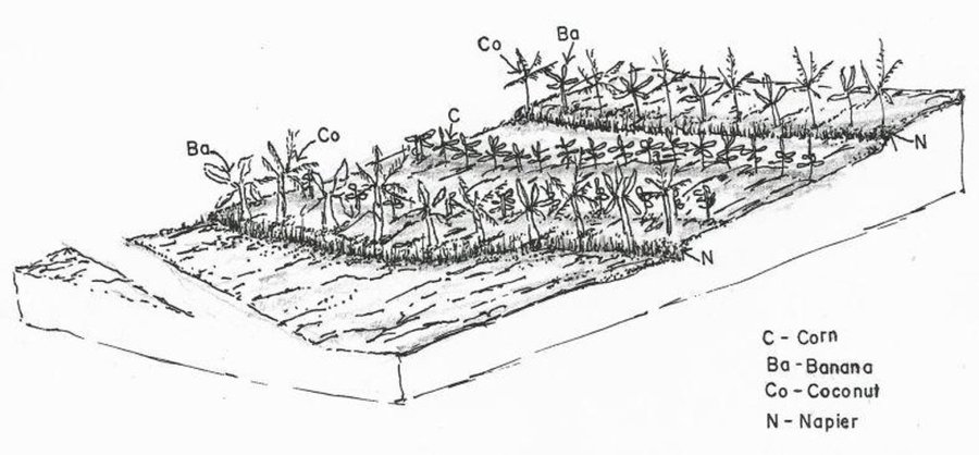
Contour farming is a technology practiced in sloping areas in which hedgerows are established along the contours and other annual/cash crops are grown in the alleys between the hedges.
Contour farming is being practiced by the farmers in sloping areas to prevent or control soil erosion. Hedgerows are established along contour lines using napier grass and permanent crops like banana and coconut. In between contour lines, corn is inter-cropped with peanut. It is a traditional practice of farmers and one of the conservation techniques for the Conservation Farming Village Approach (CFV).
Purpose of the Technology: This is practiced by farmers to control surface run-off, erosion and to conserve natural soil fertility. Napier grass is also planted as source of feeds for the livestocks. The technology controls dispersed runoff, reduce slope angle and length.
Establishment / maintenance activities and inputs: Contour lines were established using an A-frame to determine the location of the hedgerows to be planted. Napier grasses are planted along the contour at 8x8m and 4X4m distance. Grafted cacao trees are also inserted in between banana at 4X4 distance. The alleys between hedges measuring 4m wide and 30m long are planted with corn and peanut. Napier grass is regularly trimmed to maintain a height of not more than a meter, using the cuttings as livestock fodder.
Natural / human environment: The area is under a humid climate condition with an average annual rainfall of 1000-1500 mm. Its elevation is 500-1000 m above mean sea level.The average cropland size of land users is less than or equal to 0. 5 hectare with a slope ranging from 18-25%. Income of land users are derived from the crops sold. The Local Government Unit (LGU) provides truck to transport the harvested crops of the farmers from the village to the town market twice a week.
สถานที่
สถานที่: Negros Oriental, La Libertad, ฟิลิปปินส์
ตำนวนการวิเคราะห์เทคโนโลยี:
ตำแหน่งทางภูมิศาสตร์ของสถานที่ที่ถูกเลือ
การเผยแพร่ของเทคโนโลยี: กระจายไปอย่างสม่ำเสมอในพื้นที่ (approx. < 0.1 ตร.กม.(10 เฮกตาร์))
วันที่ในการดำเนินการ: มากกว่า 50 ปี (แบบดั้งเดิม)
ประเภทของการแนะนำ
-
ด้วยการริเริ่มของผู้ใช้ที่ดินเอง
-
เป็นส่วนหนึ่งของระบบแบบดั้งเดิมที่ทำก้นอยู่ (> 50 ปี)
-
ในช่วงการทดลองหรือการทำวิจัย
-
ทางโครงการหรือจากภายนอก
-
Interview with land user on the technology (Engr. Djolly Ma. P. Dinamling)
จุดประสงค์หลัก
-
ปรับปรุงการผลิตให้ดีขึ้น
-
ลด ป้องกัน ฟื้นฟู การเสื่อมโทรมของที่ดิน
-
อนุรักษ์ระบบนิเวศน์
-
ป้องกันพื้นที่ลุ่มน้ำ/บริเวณท้ายน้ำ โดยร่วมกับเทคโนโลยีอื่นๆ
-
รักษาสภาพหรือปรับปรุงความหลากหลายทางชีวภาพ
-
ลดความเสี่ยงของภัยพิบัติ
-
ปรับตัวเข้ากับการเปลี่ยนแปลงภูมิอากาศของโลก สภาพภูมิอากาศที่รุนแรงและผลกระทบ
-
ชะลอการเปลี่ยนแปลงภูมิอากาศของโลกและผลกระทบ
-
สร้างผลกระทบทางด้านเศรษฐกิจที่เป็นประโยชน์
-
สร้างผลกระทบทางด้านสังคมที่เป็นประโยชน์
การใช้ที่ดิน
-
พื้นที่ปลูกพืช - การปลูกพืชล้มลุกอายุปีเดียว
พืชหลัก (พืชเศรษฐกิจและพืชอาหาร): major cash crop: peanut
major food crop: corn, banana, cacao, coconut
Other: Napier grasses
การใช้น้ำ
-
จากน้ำฝน
-
น้ำฝนร่วมกับการชลประทาน
-
การชลประทานแบบเต็มรูปแบบ
จำนวนของฤดูปลูกต่อปี:
n.a.
การใช้ที่ดินก่อนการดำเนินการโดยเทคโนโลยี:
n.a.
ความหนาแน่นของปศุสัตว์:
n.a.
ความมุ่งหมายที่เกี่ยวข้องกับการเสื่อมโทรมของที่ดิน
-
ป้องกันความเสื่อมโทรมของที่ดิน
-
ลดความเสื่อมโทรมของดิน
-
ฟื้นฟูบำบัดที่ดินที่เสื่อมโทรมลงอย่างมาก
-
ปรับตัวกับสภาพความเสื่อมโทรมของที่ดิน
-
ไม่สามารถใช้ได้
ที่อยู่ของการเสื่อมโทรม
-
การกัดกร่อนของดินโดยน้ำ - Wt (Loss of topsoil): การสูญเสียดินชั้นบนหรือการกัดกร่อนที่ผิวดิน
-
การเสื่อมโทรมของดินทางด้านเคมี - Cn (Fertility decline): ความอุดมสมบูรณ์และปริมาณอินทรียวัตถุในดินถูกทำให้ลดลงไป (ไม่ได้เกิดจากสาเหตุการกัดกร่อน)
-
การเสื่อมโทรมของดินทางด้านชีวภาพ - Bc (Reduction of vegetation cover): การลดลงของจำนวนพืชที่ปกคลุมดิน
กลุ่ม SLM
-
มาตรการปลูกพืชขวางความลาดชัน (cross-slope measure)
มาตรการ SLM
-
มาตรการจัดการพืช - A1: พืช/สิ่งปกคลุมดิน, A2: อินทรียวัตถุในดิน/ความอุดมสมบูรณ์ในดิน, A3: การรักษาหน้าดิน, A4: การรักษาดินชั้นล่าง
-
มาตรการอนุรักษ์ด้วยวิธีพืช - V1: ต้นไม้และพุ่มไม้คลุมดิน, V2: หญ้าและไม้ยืนต้น
แบบแปลนทางเทคนิค
ข้อมูลจำเพาะด้านเทคนิค
ผู้เขียน Mr. Patricio A. Yambot, Bureau of Soils and Water Management
Crops planted in the contour.
Location: Brgy. Talaon. La Libertad, Negros Oriental
Date: May28, 2015
Technical knowledge required for field staff / advisors: high
Technical knowledge required for land users: moderate
Main technical functions: control of raindrop splash, control of dispersed runoff: retain / trap, Minimize soil erosion due to runoff, Serve as soil nutrient traps
Secondary technical functions: reduction of slope angle, reduction of slope length, stabilisation of soil (eg by tree roots against land slides), promotion of vegetation species and varieties (quality, eg palatable fodder)
Mixed cropping / intercropping
Material/ species: corn and peanut
Quantity/ density: 10kg/.25ha
Remarks: in between contour hedges
Contour planting / strip cropping
Material/ species: napier, banana, coconut and cacao
Quantity/ density: 20kg/.25ha
Legume inter-planting
Quantity/ density: 20kg/.25ha
Manure / compost / residues
Material/ species: vermi-compost
Quantity/ density: 500kg
Breaking crust / sealed surface
Material/ species: rotavator
Remarks: plowing two times
Aligned: -contour
Vegetative material: G : grass
Number of plants per (ha): 500
Vertical interval between rows / strips / blocks (m): 0.5
Spacing between rows / strips / blocks (m): 4
Vertical interval within rows / strips / blocks (m): drill
Width within rows / strips / blocks (m): 0.3
Vegetative measure: contour (banana)
Vegetative material: F : fruit trees / shrubs
Number of plants per (ha): 64
Vertical interval between rows / strips / blocks (m): 0.5
Spacing between rows / strips / blocks (m): 4
Vertical interval within rows / strips / blocks (m): 4
Width within rows / strips / blocks (m): 4
Vegetative measure: contour (cacao)
Vegetative material: F : fruit trees / shrubs
Number of plants per (ha): 64
Vertical interval between rows / strips / blocks (m): 0.5
Spacing between rows / strips / blocks (m): 4
Vertical interval within rows / strips / blocks (m): 1
Width within rows / strips / blocks (m): 4
Vegetative measure: contour (cococnut)
Vegetative material: F : fruit trees / shrubs
Number of plants per (ha): 32
Vertical interval between rows / strips / blocks (m): 0.5
Spacing between rows / strips / blocks (m): 4
Vertical interval within rows / strips / blocks (m): 8
Width within rows / strips / blocks (m): 8
Vegetative measure: Vegetative material: F : fruit trees / shrubs
Fruit trees / shrubs species: banana, cacao, coconut
Grass species: napier grass
Slope (which determines the spacing indicated above): 8%
If the original slope has changed as a result of the Technology, the slope today is (see figure below): 5%
Gradient along the rows / strips: 3-5%
การจัดตั้งและการบำรุงรักษา: กิจกรรม ปัจจัยและค่าใช้จ่าย
การคำนวนต้นทุนและค่าใช้จ่าย
- ค่าใช้จ่ายถูกคำนวน ต่อพื้นที่ที่ใช้เทคโนโลยี (หน่วยของขนาดและพื้นที่: 1 hectare)
- สกุลเงินที่ใช้คำนวณค่าใช้จ่าย ดอลลาร์สหรัฐ
- อัตราแลกเปลี่ยน (ไปเป็นดอลลาร์สหรัฐ) คือ 1 ดอลลาร์สหรัฐ = 49.0
- ค่าจ้างเฉลี่ยในการจ้างแรงงานต่อวันคือ 2.22
ปัจจัยที่สำคัญที่สุดที่มีผลต่อค่าใช้จ่าย
The slope of the area contributes to the additional labor cost in the establishment of contours.The steeper the slope, the higher labor cost will be incurred.
กิจกรรมเพื่อการจัดตั้ง
-
Laying out and establishment of contour lines/hedgerows (ช่วงระยะเวลา/ความถี่: before onset of rainy season)
-
Planting of hedgerows (Napier grass) (ช่วงระยะเวลา/ความถี่: Rainy season. one week after laying out)
-
Planting of perennial crops along contour (ช่วงระยะเวลา/ความถี่: Rainy season. 1 week after laying out)
ปัจจัยและค่าใช้จ่ายของการจัดตั้ง (per 1 hectare)
| ปัจจัยนำเข้า |
หน่วย |
ปริมาณ |
ค่าใช้จ่ายต่อหน่วย (ดอลลาร์สหรัฐ) |
ค่าใช้จ่ายทั้งหมดต่อปัจจัยนำเข้า (ดอลลาร์สหรัฐ) |
%ของค่าใช้จ่ายที่ก่อให้เกิดขึ้นโดยผู้ใช้ที่ดิน |
|
แรงงาน
|
| Laying out and establishment of contour |
Person/day |
3.0 |
2.22 |
6.66 |
40.0 |
| Planting of crops and hedgerows |
Person/day |
10.0 |
2.22 |
22.2 |
100.0 |
|
วัสดุด้านพืช
|
| napier seeds |
kg |
300.0 |
0.0133 |
3.99 |
100.0 |
| banana seeds |
plants |
64.0 |
0.11093 |
7.1 |
100.0 |
| cacao seeds |
plants |
64.0 |
0.55565 |
35.56 |
100.0 |
| coconut seeds |
plants |
32.0 |
0.88875 |
28.44 |
100.0 |
|
ปุ๋ยและสารฆ่า/ยับยั้งการเจริญเติบโตของสิ่งมีชีวิต (ไบโอไซด์)
|
| herbicide |
liter |
1.0 |
17.78 |
17.78 |
40.0 |
|
วัสดุสำหรับก่อสร้าง
|
| bamboosticks |
picks |
50.0 |
0.012 |
0.6 |
40.0 |
| A-frame |
unit |
1.0 |
0.44 |
0.44 |
40.0 |
| ค่าใช้จ่ายทั้งหมดของการจัดตั้งเทคโนโลยี |
122.77 |
|
กิจกรรมสำหรับการบำรุงรักษา
-
Land clearing/ preparation (plowing, rotavating, harrowing) of alleys between contours (ช่วงระยะเวลา/ความถี่: Before onset of rainy season)
-
Furrowing (ช่วงระยะเวลา/ความถี่: None)
-
Planting of corn (first cropping) (ช่วงระยะเวลา/ความถี่: Raining season)
-
Weeding, insect control (ช่วงระยะเวลา/ความถี่: None)
-
Harvesting of first crop (ช่วงระยะเวลา/ความถี่: None)
-
Land Preparation for the second cropping (plowing, harrowing/rotavating, furrowing) (ช่วงระยะเวลา/ความถี่: None)
-
Planting of corn + Planting of peanut (second cropping- corn + peanut) (ช่วงระยะเวลา/ความถี่: None)
-
Weeding / Insect control (ช่วงระยะเวลา/ความถี่: None)
-
Harvesting of corn and peanut (ช่วงระยะเวลา/ความถี่: None)
ปัจจัยและค่าใช้จ่ายของการบำรุงรักษา (per 1 hectare)
| ปัจจัยนำเข้า |
หน่วย |
ปริมาณ |
ค่าใช้จ่ายต่อหน่วย (ดอลลาร์สหรัฐ) |
ค่าใช้จ่ายทั้งหมดต่อปัจจัยนำเข้า (ดอลลาร์สหรัฐ) |
%ของค่าใช้จ่ายที่ก่อให้เกิดขึ้นโดยผู้ใช้ที่ดิน |
|
แรงงาน
|
| Land Preparation with machine / furrowing |
Person/day |
3.0 |
7.11 |
21.33 |
100.0 |
| Animal Labour |
Person/day |
2.0 |
2.67 |
5.34 |
100.0 |
|
อุปกรณ์
|
| Other Labour: Weeding, harvesting |
Person/day |
14.0 |
2.22 |
31.08 |
100.0 |
|
วัสดุด้านพืช
|
| Corn seeds |
kg |
10.0 |
0.444 |
4.44 |
|
| Peanut seeds |
kg |
20.0 |
2.0 |
40.0 |
100.0 |
| Seeds undefined |
kg |
10.0 |
0.444 |
4.44 |
100.0 |
|
ปุ๋ยและสารฆ่า/ยับยั้งการเจริญเติบโตของสิ่งมีชีวิต (ไบโอไซด์)
|
| Fertilizer |
kg |
500.0 |
0.08 |
40.0 |
100.0 |
| ค่าใช้จ่ายทั้งหมดของการบำรุงรักษาสภาพเทคโนโลยี |
146.63 |
|
สิ่งแวดล้อมทางธรรมชาติ
ปริมาณน้ำฝนเฉลี่ยรายปี
-
< 250 ม.ม.
-
251-500 ม.ม.
-
501-750 ม.ม.
-
751-1,000 ม.ม.
-
1,001-1,500 ม.ม.
-
1,501-2,000 ม.ม.
-
2,001-3,000 ม.ม.
-
3,001-4,000 ม.ม.
-
> 4,000 ม.ม.
เขตภูมิอากาศเกษตร
-
ชื้น
-
กึ่งชุ่มชื้น
-
กึ่งแห้งแล้ง
-
แห้งแล้ง
ข้อมูลจำเพาะเรื่องภูมิอากาศ
Thermal climate class: tropics
ความชัน
-
ราบเรียบ (0-2%)
-
ลาดที่ไม่ชัน (3-5%)
-
ปานกลาง (6-10%)
-
เป็นลูกคลื่น (11-15%)
-
เป็นเนิน (16-30%)
-
ชัน (31-60%)
-
ชันมาก (>60%)
ภูมิลักษณ์
-
ที่ราบสูง/ที่ราบ
-
สันเขา
-
ไหล่เขา
-
ไหล่เนินเขา
-
ตีนเนิน
-
หุบเขา
ความสูง
-
0-100 เมตร
-
101-500 เมตร
-
501-1,000 เมตร
-
1,001-1,500 เมตร
-
1,501-2,000 เมตร
-
2,001-2,500 เมตร
-
2,501-3,000 เมตร
-
3,001-4,000 เมตร
-
> 4,000 เมตร
เทคโนโลยีถูกประยุกต์ใช้ใน
-
บริเวณสันเขา (convex situations)
-
บริเวณแอ่งบนที่ราบ (concave situations)
-
ไม่เกี่ยวข้อง
ความลึกของดิน
-
ตื้นมาก (0-20 ซ.ม.)
-
ตื้น (21-50 ซ.ม.)
-
ลึกปานกลาง (51-80 ซ.ม.)
-
ลึก (81-120 ซ.ม.)
-
ลึกมาก (>120 ซ.ม.)
เนื้อดิน (ดินชั้นบน)
-
หยาบ/เบา (ดินทราย)
-
ปานกลาง (ดินร่วน ทรายแป้ง)
-
ละเอียด/หนัก (ดินเหนียว)
เนื้อดิน (> 20 ซม. ต่ำกว่าพื้นผิว)
-
หยาบ/เบา (ดินทราย)
-
ปานกลาง (ดินร่วน ทรายแป้ง)
-
ละเอียด/หนัก (ดินเหนียว)
สารอินทรียวัตถุในดิน
-
สูง (>3%)
-
ปานกลาง (1-3%)
-
ต่ำ (<1%)
น้ำบาดาล
-
ที่ผิวดิน
-
<5 เมตร
-
5-50 เมตร
-
> 50 เมตร
ระดับน้ำบาดาลที่ผิวดิน
-
เกินพอ
-
ดี
-
ปานกลาง
-
ไม่ดีหรือไม่มีเลย
คุณภาพน้ำ (ยังไม่ได้รับการบำบัด)
-
เป็นน้ำเพื่อการดื่มที่ดี
-
เป็นน้ำเพื่อการดื่มที่ไม่ดี (จำเป็นต้องได้รับการบำบัด)
-
เป็นน้ำใช้เพื่อการเกษตรเท่านั้น (การชลประทาน)
-
ใช้ประโยชน์ไม่ได้
ความเค็มของน้ำเป็นปัญหาหรือไม่?
การเกิดน้ำท่วม
ความหลากหลายทางชนิดพันธุ์
ความหลากหลายของแหล่งที่อยู่
ลักษณะเฉพาะของผู้ใช้ที่ดินที่ประยุกต์ใช้เทคโนโลยี
เป้าหมายทางการตลาด
-
เพื่อการยังชีพ (หาเลี้ยงตนเอง)
-
ผสม (การเลี้ยงชีพ/ทำการค้า)
-
ทำการค้า/การตลาด
รายได้จากภายนอกฟาร์ม
-
< 10% ของรายได้ทั้งหมด
-
10-50% ของรายได้ทั้งหมด
-
> 50% ของรายได้ทั้งหมด
ระดับของความมั่งคั่งโดยเปรียบเทียบ
-
ยากจนมาก
-
จน
-
พอมีพอกิน
-
รวย
-
รวยมาก
ระดับของการใช้เครื่องจักรกล
-
งานที่ใช้แรงกาย
-
การใช้กำลังจากสัตว์
-
การใช้เครื่องจักรหรือเครื่องยนต์
อยู่กับที่หรือเร่ร่อน
-
อยู่กับที่
-
กึ่งเร่ร่อน
-
เร่ร่อน
เป็นรายบุคคลหรือกลุ่ม
-
เป็นรายบุคคล/ครัวเรือน
-
กลุ่ม/ชุมชน
-
สหกรณ์
-
ลูกจ้าง (บริษัท รัฐบาล)
อายุ
-
เด็ก
-
ผู้เยาว์
-
วัยกลางคน
-
ผู้สูงอายุ
พื้นที่ที่ใช้ต่อครัวเรือน
-
< 0.5 เฮกตาร์
-
0.5-1 เฮกตาร์
-
1-2 เฮกตาร์
-
2-5 เฮกตาร์
-
5-15 เฮกตาร์
-
15-50 เฮกตาร์
-
50-100 เฮกตาร์
-
100-500 เฮกตาร์
-
500-1,000 เฮกตาร์
-
1,000-10,000 เฮกตาร์
-
>10,000 เฮกตาร์
ขนาด
-
ขนาดเล็ก
-
ขนาดกลาง
-
ขนาดใหญ่
กรรมสิทธิ์ในที่ดิน
-
รัฐ
-
บริษัท
-
เป็นแบบชุมชนหรือหมู่บ้าน
-
กลุ่ม
-
รายบุคคล ไม่ได้รับสิทธิครอบครอง
-
รายบุคคล ได้รับสิทธิครอบครอง
สิทธิในการใช้ที่ดิน
-
เข้าถึงได้แบบเปิด (ไม่ได้จัดระเบียบ)
-
เกี่ยวกับชุมชน (ถูกจัดระเบียบ)
-
เช่า
-
รายบุคคล
สิทธิในการใช้น้ำ
-
เข้าถึงได้แบบเปิด (ไม่ได้จัดระเบียบ)
-
เกี่ยวกับชุมชน (ถูกจัดระเบียบ)
-
เช่า
-
รายบุคคล
เข้าถึงการบริการและโครงสร้างพื้นฐาน
ความช่วยเหลือทางด้านเทคนิค
การจ้างงาน (เช่น ภายนอกฟาร์ม)
ผลกระทบ
ผลกระทบทางด้านเศรษฐกิจและสังคม
การผลิตพืชผล
จำนวนก่อน SLM: 0
หลังจาก SLM: 10 bags
การผลิตพืชที่ใช้เลี้ยงปศุสัตว์
จำนวนก่อน SLM: 0
หลังจาก SLM: 1350 bundles
คุณภาพพืชที่ใช้เลี้ยงปศุสัตว์
ความหลากหลายของแหล่งผลิตรายได้
ผลกระทบด้านสังคมและวัฒนธรรม
สถานการณ์ของกลุ่มด้อยโอกาส ทางด้านสังคมและเศรษฐกิจ (เพศ อายุ สถานภาพ ความเป็นกลุ่มทางชาติพันธุ์)
Improved livelihood and human well-being
ผลกระทบด้านนิเวศวิทยา
การหมุนเวียนและการเติมของธาตุอาหาร
อินทรียวัตถุในดิน/ต่ำกว่าดินชั้น C
ความหลากหลายทางชีวภาพของพืช
การปล่อยคาร์บอนและก๊าซเรือนกระจก
ผลกระทบนอกพื้นที่ดำเนินการ
รายได้และค่าใช้จ่าย
ผลประโยชน์ที่ได้รับเปรียบเทียบกับค่าใช้จ่าย
ผลตอบแทนระยะสั้น
ด้านลบอย่างมาก
ด้านบวกอย่างมาก
ผลตอบแทนระยะยาว
ด้านลบอย่างมาก
ด้านบวกอย่างมาก
ผลประโยชน์ที่ได้รับเปรียบเทียบกับค่าใช้จ่ายในการบำรุงรักษา
ผลตอบแทนระยะสั้น
ด้านลบอย่างมาก
ด้านบวกอย่างมาก
ผลตอบแทนระยะยาว
ด้านลบอย่างมาก
ด้านบวกอย่างมาก
การเปลี่ยนแปลงของสภาพภูมิอากาศ
การเปลี่ยนแปลงสภาพภูมิอากาศที่ค่อยเป็นค่อยไป
อุณหภูมิประจำปี เพิ่มขึ้น
สภาพรุนแรงของภูมิอากาศ (ภัยพิบัติ)
การน้อมเอาความรู้และการปรับใช้
เปอร์เซ็นต์ของผู้ใช้ที่ดินในพื้นที่ที่นำเทคโนโลยีไปใช้
-
ครั้งเดียวหรือเป็นการทดลอง
-
1-10%
-
10-50%
-
มากกว่า 50%
จากทั้งหมดที่ได้รับเทคโนโลยีเข้ามามีจำนวนเท่าใดที่ทำแบบทันที โดยไม่ได้รับการจูงใจด้านวัสดุหรือการเงินใดๆ?
-
0-10%
-
10-50%
-
50-90%
-
90-100%
จำนวนหลังคาเรือนหรือขนาดพื้นที่รวมทั้งหมด
18 land user families have adopted the Technology
เทคโนโลยีได้รับการปรับเปลี่ยนเร็วๆ นี้เพื่อให้ปรับตัวเข้ากับสภาพที่กำลังเปลี่ยนแปลงหรือไม่?
สภาพที่กำลังเปลี่ยนแปลงอันไหน?
-
การเปลี่ยนแปลงแบบค่อยเป็นค่อยไปและสภาพรุนแรงของภูมิอากาศ
-
การเปลี่ยนแปลงของตลาด
-
การมีแรงงานไว้ให้ใช้ (เนื่องจากการอพยพย้ายถิ่นฐาน)
บทสรุปหรือบทเรียนที่ได้รับ
จุดแข็ง: มุมมองของผู้ใช้ที่ดิน
-
Availability of labor force in the community.
How can they be sustained / enhanced? Encourage more farmers to adopt the technology and utilize available labor force.
-
The technology generated jobs and increase the income of the landusers practicing the technology.
How can they be sustained / enhanced? To conduct continuous capacity building to land users and their children to ensure sustainability.
จุดแข็ง: ทัศนคติของผู้รวบรวมหรือวิทยากรคนอื่นๆ
-
Soil erosion was reduced because of the presence of the hedge rows that traps eroded soil.
How can they be sustained / enhanced? Include other structural measures such as silt traps and brush dams to trap silts.
-
The kind of hedgerows planted depends on the need of the landusers. Farmers with livestock used napier and forage grasses as hedges while others planted perennial and cash crop to supplement their food requirement.
How can they be sustained / enhanced? Conduct crop suitability evaluation and market study.
จุดด้อย/ข้อเสีย/ความเสี่ยง: มุมมองของผู้ใช้ที่ดินแก้ไขปัญหาได้อย่างไร
-
Poor road network from the center of the town to the barangay.
Construction of farm-to-market road to improve the accessibility of the barangay.
จุดด้อย/ข้อเสีย/ความเสี่ยง: ทัศนคติของผู้รวบรวมหรือวิทยากรคนอื่นๆแก้ไขปัญหาได้อย่างไร
-
Lack of irrigation system in the cropping area
Provision of irrigation system such as solar pump and small farm reservoir.
การอ้างอิง
ผู้รวบรวม
-
Philippine Overview of Conservation Approaches and Technologies
ผู้ตรวจสอบ
-
Eduardo Alberto
-
Alexandra Gavilano
วันที่จัดทำเอกสาร: 22 ตุลาคม 2015
การอัพเดทล่าสุด: 29 มีนาคม 2017
วิทยากร
-
Aida Luistro - ผู้เชี่ยวชาญ SLM
-
Elizabeth Gregorio - ผู้เชี่ยวชาญ SLM
-
Djolly Ma. Dinamling - ผู้เชี่ยวชาญ SLM
-
Albert F. Gutierrez (alfergu@yahoo.com ) - ผู้เชี่ยวชาญ SLM
คำอธิบายฉบับเต็มในฐานข้อมูล WOCAT
การจัดทำเอกสารถูกทำโดย
องค์กร
- Bureau of Soils and Water Management (Bureau of Soils and Water Management) - ฟิลิปปินส์
- LGU of La Libertad - ฟิลิปปินส์
- Regional Field Office N0. 4A (RFO IV-A ) - ฟิลิปปินส์
- Southern Tagalog Integrated Agricultural Research Center (STIARC) - ฟิลิปปินส์
โครงการ