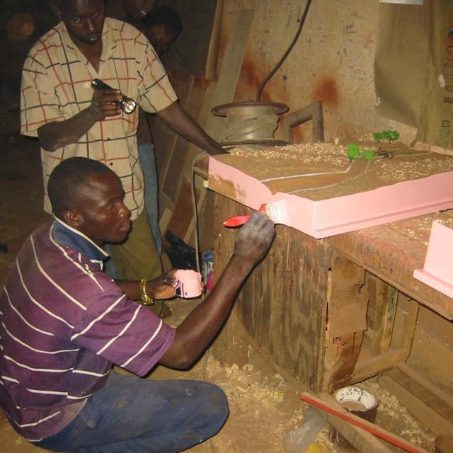


Scale models are an instructional tool that can be used to ensure a common understanding of the characteristics of the lowland area to be developed, give concrete expression to the baseline scenario, and facilitate discussion of the different technical options for the development. Depending on the case at hand, the model shows flooded areas, forested areas, housing, areas given over to pasture or cultivation and the type of scheme that has been chosen with the beneficiaries. Ultimately, a wooden 3D version of the model is produced that is around 80 x 120 centimetres in size. The model is a visual aid that improves communication between the different actors involved and the technical designers during the planning process and development of the lowland area (communities, design agencies and businesses tasked with implementation, etc.). The model is a tool that helps to foster the actors’ ownership of the process, the creation of a shared future vision of the development, and the collaborative management of schemes. It must, however, form part of an overall facilitation approach.
The model is one tool in the toolkit of lowland planning approaches. The process begins with the request by a community and/or local authority for a scheme. A brief for the development scheme is then drawn up jointly by those involved. The project itself starts with a socio-economic study carried out in accordance with the ToR submitted to the community. Approval for the choice of site is obtained in the course of the socio-economic study, which leads into a technical study based on the findings and the summary draft document (SDD). Study findings are fed back to villagers along with the selected scenario. A 3D wooden model is then produced on the basis of the findings and scenario. The other scheme implementation stages are carried out following approval (summary draft document – SDD, drafting of the tender documents – ITD, choice of contractor, works, approval of works completed). The model is subsequently used to move the farming and facility maintenance strategy forward. Two or three village facilitators, who are members of the management committee, are trained in how to handle the model during facilitation sessions.
Stages in creating a model: 1)Sketch mapping (involving farmers) and a topographical survey of the area, 2)Precise order placed with the model maker (specification), 3)Provision of a quote by the model maker setting out the costs of the materials and services required (if necessary, a site visit is carried out with the model maker to work through the paper maps of the lowland area), 4)Conversion of the paper maps to the actual scale of the model, 5)Production of the base unit with the basic relief (boards, plywood), 6)Positioning of the technical features to be installed (facilities, roads, irrigated plots, ponds, etc.) and the addition of decorative elements (houses, trees, livestock), 7)Production of a protective shipping case for the model.
Beneficiaries formulate the request, describe and draw sketch maps of the landscape, and use the model in consultation exercises. The consultancy supports the design process, ensures the quality
of on-paper designs for use in constructing the model, and acts as intermediary between the beneficiaries and the woodworker, particularly in terms of converting scales and proportions. The woodworker creates the model according to the plan.
สถานที่: Sikasso, Koutiala, Kadiolo and Yorosso, San and Tominian , Mali , มาลี
วันที่ริเริ่ม: 2005
ปีที่สิ้นสุด: n.a.
ประเภทของแนวทาง
| ผู้มีส่วนได้เสียหรือองค์กรที่นำไปปฏิบัติใช้มีส่วนเกี่ยวข้องกับแนวทางนี้อย่างไร | ระบุผู้มีส่วนได้ส่วนเสีย | อธิบายบทบาทของผู้มีส่วนได้ส่วนเสีย |
| ผู้ใช้ที่ดินระดับท้องถิ่นหรือชุมชนระดับท้องถิ่น | ||
| ผู้เชี่ยวชาญ SLM หรือที่ปรึกษาการเกษตร | ||
| องค์กรพัฒนาเอกชน | HELVETAS | |
| รัฐบาลแห่งชาติ (ผู้วางแผน ผู้ทำการตัดสินใจ) |
การตัดสินใจถูกทำโดย
การตัดสินใจถูกตัดสินอยู่บนพื้นฐานของ
Local people need to get to grips with the landscape and know how to orientate themselves in the space. The model maker must be well trained and have expertise in concepts of scale, contours and ‘scale exaggerations’
Helvetas - Swiss Intercooperation
reduced conflicts over farming land and immediate visibility of the land pattern and spatial issues
It is an approach that is more engaging and accessible to all – even the shyest people are able to express themselves.
This tool has been used in the regions of Sikasso (Sikasso, Koutiala, Kadiolo and Yorosso) and Ségou (San and Tominian) for all the schemes delivered by HELVETAS Swiss Intercooperation. In total, more than 25 models have been made.