Creating scale models for the development of lowland areas and the participation of the farming community [มาลี]
- ผู้สร้างสรรค์:
- การอัพเดท:
- ผู้รวบรวม: Dieter Nill
- ผู้เรียบเรียง: –
- ผู้ตรวจสอบ: Laura Ebneter
Elaboration des maquettes pour l’aménagement des bas-fonds et la participation paysanne
approaches_2500 - มาลี
- บทสรุปทั้งหมดในรูปแบบของ PDF
- บทสรุปทั้งหมดในรูปแบบของ PDF เพื่อพิมพ์
- บทสรุปทั้งหมดในรูปหน้าเว็บ
- บทสรุปทั้งหมด (ไม่มีการจัดเรียง)
- Creating scale models for the development of lowland areas and the participation of the farming community: 7 มิถุนายน 2017 (inactive)
- Creating scale models for the development of lowland areas and the participation of the farming community: 7 มิถุนายน 2017 (inactive)
- Creating scale models for the development of lowland areas and the participation of the farming community: 7 มิถุนายน 2017 (inactive)
- Creating scale models for the development of lowland areas and the participation of the farming community: 12 มิถุนายน 2017 (public)
ดูส่วนย่อย
ขยายทั้งหมด ย่อทั้งหมด1. ข้อมูลทั่วไป
1.2 รายละเอียดที่ติดต่อได้ของผู้รวบรวมและองค์กรที่เกี่ยวข้องในการประเมินและการจัดเตรียมทำเอกสารของแนวทาง
ผู้เชี่ยวชาญ SLM:
Keita Lassana
lassana.keita@helvetas.org
HELVETAS - Swiss Intercooperation
มาลี
ผู้เชี่ยวชาญ SLM:
Dembélé Célestin
celestin.dembele@helvetas.org
HELVETAS - Swiss Intercooperation
มาลี
ผู้เชี่ยวชาญ SLM:
Dacko Maïga Rosaline
rosaline.dacko@helvetas.org
HELVETAS - Swiss Intercooperation
มาลี
ชื่อของโครงการซึ่งอำนวยความสะดวกในการทำเอกสารหรือการประเมินแนวทาง (ถ้าเกี่ยวข้อง)
HELVETAS (Swiss Intercooperation)ชื่อของโครงการซึ่งอำนวยความสะดวกในการทำเอกสารหรือการประเมินแนวทาง (ถ้าเกี่ยวข้อง)
Deutsche Gesellschaft für Internationale Zusammenarbeit (GIZ) GmbH (GIZ) - เยอรมนี1.3 เงื่อนไขที่เกี่ยวข้องกับการใช้ข้อมูลที่ได้บันทึกไว้ผ่านทาง WOCAT
วันที่เก็บรวบรวมข้อมูล (ภาคสนาม):
01/07/2012
ผู้รวบรวมและวิทยากรหลักยอมรับเงื่อนไขเกี่ยวกับการใช้ข้อมูลที่ถูกบันทึกผ่านทาง WOCAT:
ใช่
2. คำอธิบายของแนวทาง SLM
2.1 การอธิบายแบบสั้น ๆ ของแนวทาง
Creating models when developing lowland areas encourages the different actors involved to enter into negotiations and participate in decision-making on the design and farming of a lowland area.
2.2 การอธิบายอย่างละเอียดของแนวทาง
การอธิบายอย่างละเอียดของแนวทาง:
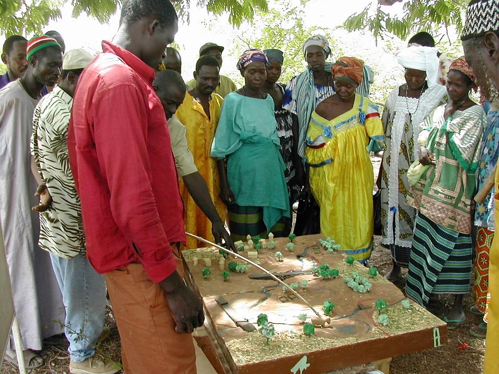
Scale models are an instructional tool that can be used to ensure a common understanding of the characteristics of the lowland area to be developed, give concrete expression to the baseline scenario, and facilitate discussion of the different technical options for the development. Depending on the case at hand, the model shows flooded areas, forested areas, housing, areas given over to pasture or cultivation and the type of scheme that has been chosen with the beneficiaries. Ultimately, a wooden 3D version of the model is produced that is around 80 x 120 centimetres in size. The model is a visual aid that improves communication between the different actors involved and the technical designers during the planning process and development of the lowland area (communities, design agencies and businesses tasked with implementation, etc.). The model is a tool that helps to foster the actors’ ownership of the process, the creation of a shared future vision of the development, and the collaborative management of schemes. It must, however, form part of an overall facilitation approach.
The model is one tool in the toolkit of lowland planning approaches. The process begins with the request by a community and/or local authority for a scheme. A brief for the development scheme is then drawn up jointly by those involved. The project itself starts with a socio-economic study carried out in accordance with the ToR submitted to the community. Approval for the choice of site is obtained in the course of the socio-economic study, which leads into a technical study based on the findings and the summary draft document (SDD). Study findings are fed back to villagers along with the selected scenario. A 3D wooden model is then produced on the basis of the findings and scenario. The other scheme implementation stages are carried out following approval (summary draft document – SDD, drafting of the tender documents – ITD, choice of contractor, works, approval of works completed). The model is subsequently used to move the farming and facility maintenance strategy forward. Two or three village facilitators, who are members of the management committee, are trained in how to handle the model during facilitation sessions.
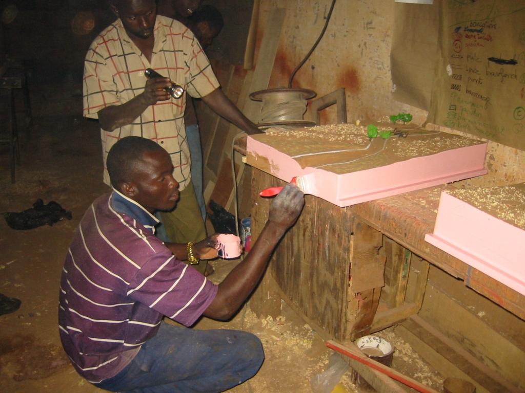
Stages in creating a model: 1)Sketch mapping (involving farmers) and a topographical survey of the area, 2)Precise order placed with the model maker (specification), 3)Provision of a quote by the model maker setting out the costs of the materials and services required (if necessary, a site visit is carried out with the model maker to work through the paper maps of the lowland area), 4)Conversion of the paper maps to the actual scale of the model, 5)Production of the base unit with the basic relief (boards, plywood), 6)Positioning of the technical features to be installed (facilities, roads, irrigated plots, ponds, etc.) and the addition of decorative elements (houses, trees, livestock), 7)Production of a protective shipping case for the model.
Beneficiaries formulate the request, describe and draw sketch maps of the landscape, and use the model in consultation exercises. The consultancy supports the design process, ensures the quality
of on-paper designs for use in constructing the model, and acts as intermediary between the beneficiaries and the woodworker, particularly in terms of converting scales and proportions. The woodworker creates the model according to the plan.
2.3 รูปภาพของแนวทาง
อัลบั้มสื่อบันทึก
2.5 ประเทศ ภูมิภาค หรือสถานที่ตั้งที่ได้นำแนวทางไปใช้
ประเทศ:
มาลี
ภูมิภาค/รัฐ/จังหวัด: :
Mali
ข้อมูลเฉพาะเพิ่มเติมของสถานที่ตั้ง:
Sikasso, Koutiala, Kadiolo and Yorosso, San and Tominian
2.6 วันที่เริ่มต้นและสิ้นสุดของแนวทาง
ระบุปีที่เริ่ม:
2005
2.7 ประเภทของแนวทาง
- ใช้โครงงานหรือแผนงานเป็นฐาน
2.8 เป้าหมายหรือวัตถุประสงค์หลักของแนวทาง
The Approach focused mainly on SLM with other activities.
Encouraging the different actors to enter into negotiations and participate in decision-making on the design and farming of a lowland areas; reduction of conflicts over farming land
The SLM Approach addressed the following problems: lack of participation of the farming community in the development of lowland areas, conflicts over farming land
2.9 เงื่อนไขที่เอื้ออำนวยหรือเป็นอุปสรรคต่อการนำเทคโนโลยีภายใต้แนวทางนี้ไปปฏิบัติใช้
การจัดตั้งระดับองค์กร
- เป็นอุปสรรค
lack of participation of the farming community in the development of lowland areas
Treatment through the SLM Approach: Creating models when developing lowland areas encourages the different actors involved to enter into negotiations and participate in decision-making on the design and farming of a lowland area.
3. การมีส่วนร่วมและบทบาทของผู้มีส่วนได้ส่วนเสียที่เกี่ยวข้อง
3.1 ผู้มีส่วนได้ส่วนเสียที่เกี่ยวข้องในแนวทางนี้และบทบาท
- ผู้ใช้ที่ดินระดับท้องถิ่นหรือชุมชนระดับท้องถิ่น
- ผู้เชี่ยวชาญ SLM หรือที่ปรึกษาการเกษตร
- องค์กรพัฒนาเอกชน
HELVETAS
- รัฐบาลแห่งชาติ (ผู้วางแผน ผู้ทำการตัดสินใจ)
3.2 การเกี่ยวข้องของผู้ใช้ที่ดินระดับท้องถิ่นหรือชุมชนระดับท้องถิ่นในช่วงต่างๆของแนวทาง
| ความเกี่ยวข้องของผู้ใช้ที่ดินระดับท้องถิ่นหรือชุมชนระดับท้องถิ่น | ระบุผู้ที่มีส่วนเกี่ยวข้องและอธิบายกิจกรรม | |
|---|---|---|
| การริเริ่มหรือการจูงใจ | ไม่ลงมือ | |
| การวางแผน | ปฏิสัมพันธ์ | |
| การดำเนินการ | ปฏิสัมพันธ์ | |
| การติดตามตรวจสอบหรือการประเมินผล | ไม่ลงมือ | |
| Research | ไม่ลงมือ |
3.4 การตัดสินใจเลือกใช้เทคโนโลยี SLM
ระบุผู้ที่ทำการตัดสินใจเลือกเทคโนโลยีมากกว่าหนึ่งวิธีไปปฏิบัติใช้:
- ผู้เชี่ยวชาญ SLM เป็นผู้ตัดสินใจหลัก ที่ติดตามให้คำปรึกษากับผู้ใช้ที่ดิน
การอธิบาย:
Decisions on the method of implementing the SLM Technology were made by mainly by SLM specialists with consultation of land users
4. การสนับสนุนด้านเทคนิค การสร้างขีดความสามารถ และการจัดการด้านความรู้
4.1 การสร้างขีดความสามารถ / การอบรม
ได้มีการจัดอบรมให้แก่ผู้ใช้ที่ดินหรือผู้มีส่วนได้ส่วนเสียคนอื่น ๆ หรือไม่:
ใช่
ให้ระบุว่าใครเป็นผู้ได้รับการอบรม:
- ผู้ใช้ที่ดิน
รูปแบบการอบรม:
- จัดการประชุมสู่สาธารณชน
- จัดคอร์ส
หัวข้อที่พูด:
Local people need to get to grips with the landscape and know how to orientate themselves in the space. The model maker must be well trained and have expertise in concepts of scale, contours and ‘scale exaggerations’
4.2 การบริการให้คำแนะนำ
ผู้ใช้ที่ดินมีการเข้าถึงการรับบริการให้คำปรึกษาหรือไม่:
ใช่
ระบุว่ามีบริการให้คำปรึกษาหรือไม่:
- ไปเยี่ยมชมสถานที่
การอธิบาย/แสดงความคิดเห็น:
Advisory service is quite adequate to ensure the continuation of land conservation activities; the model is facilitated by villagers themselves
4.3 การเสริมความแข็งแกร่งให้กับสถาบัน (การพัฒนาองค์กร)
สถาบันได้รับการจัดตั้งขึ้นมาหรือเสริมความแข็งแกร่งโดยแนวทางนี้หรือไม่:
- ใช่ ปานกลาง
ระบุระดับของสถาบันที่ได้รับการเสริมความแข็งแกร่งหรือจัดตั้งขึ้นมา:
- ท้องถิ่น
ระบุประเภทของการให้ความช่วยเหลือสนับสนุน:
- การสร้างขีดความสามารถ / การอบรม
- อุปกรณ์
4.4 การติดตามตรวจสอบและประเมินผล
การติดตามตรวจสอบและประเมินผลเป็นส่วนหนึ่งของแนวทางหรือไม่:
ใช่
ความคิดเห็น:
technical aspects were ad hoc monitored by project staff through observations
socio-cultural aspects were ad hoc monitored by project staff through observations
management of Approach aspects were ad hoc monitored by project staff through observations
There were no changes in the Approach as a result of monitoring and evaluation
There were no changes in the Technology as a result of monitoring and evaluation
4.5 การวิจัย
การวิจัยเป็นส่วนหนึ่งของแนวทางหรือไม่:
ใช่
ระบุหัวข้อเรื่อง:
- สังคมวิทยา
- เศรษฐศาสตร์หรือการตลาด
- นิเวศวิทยา
- เทคโนโลยี
ให้ข้อมูลเพิ่มเติมและให้ระบุผู้ทำการวิจัย:
Helvetas - Swiss Intercooperation
5. การสนับสนุนด้านการเงินและวัสดุอุปกรณ์
5.1 ระบุงบประมาณประจำปีสำหรับแนวทาง SLM นี้
ถ้าหากว่างบประมาณประจำปีไม่เป็นที่ทราบแน่นอน ให้ระบุช่วงลงไป:
- < 2,000
แสดงความคิดเห็น (แหล่งของการระดมทุน ผู้บริจาคคนสำคัญ):
Approach costs were met by the following donors: international non-government: 100.0%
5.2 การสนับสนุนด้านการเงิน / วัสดุอุปกรณ์ให้แก่ผู้ใช้ที่ดิน
ผู้ใช้ที่ดินได้รับการสนับสนุนด้านการเงิน / วัสดุอุปกรณ์ไปปฏิบัติใช้เทคโนโลยีหรือไม่:
ใช่
5.3 เงินสนับสนุนสำหรับปัจจัยนำเข้า (รวมถึงแรงงาน)
ถ้าแรงงานโดยผู้ใช้ที่ดินเป็นปัจจัยนำเข้าที่มีอยู่มากมาย ระบุด้วยว่าเนื่องจาก:
- สมัครใจ
5.4 เครดิต
มีการจัดหาเครดิตมาให้ภายใต้แนวทาง SLM หรือไม่:
ไม่ใช่
6. การวิเคราะห์ผลกระทบและการสรุป
6.1 ผลกระทบของแนวทาง
ช่วยให้ผู้ใช้ที่ดินนำเอาเทคโนโลยี SLMไปใช้และบำรุงรักษาสภาพไว้ได้หรือไม่:
- ไม่ใช่
- ใช่ เล็กน้อย
- ใช่ ปานกลาง
- ใช่ อย่างมาก
reduced conflicts over farming land and immediate visibility of the land pattern and spatial issues
ทำให้กลุ่มด้อยโอกาสมีอำนาจทางสังคมและเศรษฐกิจหรือไม่:
- ไม่ใช่
- ใช่ เล็กน้อย
- ใช่ ปานกลาง
- ใช่ อย่างมาก
It is an approach that is more engaging and accessible to all – even the shyest people are able to express themselves.
Did other land users / projects adopt the Approach?
- ไม่ใช่
- ใช่ เล็กน้อย
- ใช่ ปานกลาง
- ใช่ อย่างมาก
This tool has been used in the regions of Sikasso (Sikasso, Koutiala, Kadiolo and Yorosso) and Ségou (San and Tominian) for all the schemes delivered by HELVETAS Swiss Intercooperation. In total, more than 25 models have been made.
Did the Approach lead to improved livelihoods / human well-being?
- ไม่ใช่
- ใช่ เล็กน้อย
- ใช่ ปานกลาง
- ใช่ อย่างมาก
The model is tangible, durable and helps reduce social conflict. Involvement and motivation of local people in the design process is ensured. The model enables stakeholders to interpret the landscape and thus helps them in the decision-making process. It is used in consultation exercises to ensure transparency and consensual management in the implementation and evaluation of the scheme.
Did the Approach help to alleviate poverty?
- ไม่ใช่
- ใช่ เล็กน้อย
- ใช่ ปานกลาง
- ใช่ อย่างมาก
6.2 แรงจูงใจหลักของผู้ใช้ที่ดินเพื่อที่จะนำ SLM ไปปฏิบัติใช้
- การผลิตที่เพิ่มขึ้น
- กำไร (ความสามารถ) อัตราส่วนค่าใช้จ่ายต่อผลประโยชน์ที่เพิ่มขึ้น
- การจ่ายเงินหรือการช่วยเหลือ
- จิตสำนึกด้านสิ่งแวดล้อม
- well-being and livelihoods improvement
6.3 ความยั่งยืนของกิจกรรมของแนวทาง
ผู้ใช้ที่ดินสามารถทำให้สิ่งต่างๆ ที่ได้ปฏิบัติใช้โดยแนวทางนี้ยั่งยืนได้หรือไม่ (โดยไม่มีการสนับสนุนจากภายนอก):
- ใช่
6.4 จุดแข็งและข้อได้เปรียบของแนวทาง
| จุดแข็ง / ข้อได้เปรียบของแนวทางในทัศนคติของผู้รวบรวมหรือวิทยากรหลัก |
|---|
| The results are immediate and manifest as: reduced conflicts over farming the land in question; the immediate visibility of the land pattern and spatial issues; the involvement and motivation of local people in the design process; more inclusive decisions and the initiation of social dialogue on the scheme; an approach that is more engaging and accessible to all – even the shyest people are able to express themselves. (How to sustain/ enhance this strength: The approach must be participatory; it should not exclude any sector of society. In this respect, young people and women prove to be very good facilitators, with the model helping them to present the subject matter in a lively and engaging way.) |
|
The model enables stakeholders to interpret the landscape and thus helps them in the decision-making process. It is used in consultation exercises to ensure transparency and consensual management in the implementation and evaluation of the scheme. (How to sustain/ enhance this strength: To use the model, all that is required is for it to be transported to the meeting/facilitation space, removed from its case and placed at table height or even on the ground. The facilitator then introduces the project, indicating the landmarks and cardinal directions. This serves as the basis for discussion. Local people need to get to grips with the landscape and know how to orientate themselves in the space. The model maker must be well trained and have expertise in concepts of scale, contours and ‘scale exaggerations’. They must have an artist’s eye. ) |
| The model is tangible, durable and helps reduce social conflict. It also serves as a support for meetings with visitors. It is facilitated by villagers themselves. |
6.5 จุดอ่อน / ข้อเสียเปรียบของแนวทางและวิธีในการแก้ไข
| จุดอ่อน / ข้อเสียเปรียบในทัศนคติของผู้รวบรวมหรือวิทยากรหลัก | สามารถแก้ไขปัญหาได้อย่างไร |
|---|---|
| Some experts from technical consultancies have the tendency to take over from the beneficiaries. Other public sector experts move things forward as quickly as possible and fail to take into account villagers’ contributions. |
To ensure that people are not left frustrated and, as a result, participate less in the process, it is important to give them the opportunity to express their views. |
| Modifications may be required once the model is completed. Integrating these corrections can prove difficult (engaging the same provider and carrying out alterations without diminishing the appearance of the model). |
7. การอ้างอิงและการเชื่อมต่อ
7.1 วิธีการหรือแหล่งข้อมูล
- ไปเยี่ยมชมภาคสนาม การสำรวจพื้นที่ภาคสนาม
- การสัมภาษณ์กับผู้ใช้ที่ดิน
7.2 การอ้างอิงถึงสิ่งตีพิมพ์
ชื่อเรื่อง ผู้เขียน ปี ISBN:
Intercooperation, Délégation au Sahel (n.d.): Capitalisation d’éxperience. Eau, terre, communautés. La maquette pédagogique transportable dans l’aménagement des bas-fonds. Un outil pour les practiciens. [Delegation to the Sahel (n.d.): Capitalising on experiences. Water, land, communities. The portable instructional model for developing lowland schemes. A tool for practitioners.]
ช่องทางในการสืบค้น และราคา:
http://agriwaterpedia.info/wiki/Main_Page
ชื่อเรื่อง ผู้เขียน ปี ISBN:
Intercooperation, Délégation au Sahel (2009): Gestion des ressources naturelles: les acteurs s’engagent pour une gestion concertée et pacifique de leurs resources. [Delegation to the Sahel (2009): Management of natural resources – actors engage in the collaborative and peaceful management of their resources.]
ชื่อเรื่อง ผู้เขียน ปี ISBN:
Good Practices in Soil and Water Conservation. A contribution to adaptation and farmers´ resilience towards climate change in the Sahel. Published by GIZ in 2012.
ช่องทางในการสืบค้น และราคา:
http://agrwaterpedia.info/wiki/Main_Page
ลิงก์และโมดูล
ขยายทั้งหมด ย่อทั้งหมดลิงก์
ไม่มีลิงก์
โมดูล
ไม่มีโมดูล