Creating scale models for the development of lowland areas and the participation of the farming community [Мали ]
- Шинийг нээх:
- Шинэчлэх:
- Мэдээлэл цуглуулсан: Dieter Nill
- Редактор: –
- Хянагч: Laura Ebneter
Elaboration des maquettes pour l’aménagement des bas-fonds et la participation paysanne
approaches_2500 - Мали
- Бүрэн хураангуйг PDF-ээр
- Бүрэн хураангуйг PDF-ээр хэвлэх
- Хөтөч дэх бүрэн хураангуй
- Бүрэн хураангуй (форматгүй)
- Creating scale models for the development of lowland areas and the participation of the farming community: 12 6-р сар 2017 (public)
- Creating scale models for the development of lowland areas and the participation of the farming community: 07 6-р сар 2017 (inactive)
- Creating scale models for the development of lowland areas and the participation of the farming community: 07 6-р сар 2017 (inactive)
- Creating scale models for the development of lowland areas and the participation of the farming community: 07 6-р сар 2017 (inactive)
Бүлгүүдийг үзэх
Бүгдийг харуулах Бүгдийг хаах1. Ерөнхий мэдээлэл
1.2 Арга барилыг баримтжуулах болон үнэлгээ хийхэд оролцсон хүн эсвэл байгууллагын холбоо барих хаяг
ГТМ мэргэжилтэн :
Keita Lassana
lassana.keita@helvetas.org
HELVETAS - Swiss Intercooperation
Мали
ГТМ мэргэжилтэн :
Dembélé Célestin
celestin.dembele@helvetas.org
HELVETAS - Swiss Intercooperation
Мали
ГТМ мэргэжилтэн :
Dacko Maïga Rosaline
rosaline.dacko@helvetas.org
HELVETAS - Swiss Intercooperation
Мали
Арга барилыг баримтжуулах/үнэлэх ажилд дэмжлэг үзүүлсэн байгууллага(ууд)-ын нэр (шаардлагатай бол)
HELVETAS (Swiss Intercooperation)Арга барилыг баримтжуулах/үнэлэх ажилд дэмжлэг үзүүлсэн байгууллага(ууд)-ын нэр (шаардлагатай бол)
Deutsche Gesellschaft für Internationale Zusammenarbeit (GIZ) - Герман1.3 WOCAT-аар баримтжуулсан өгөгдлийг ашиглахтай холбоотой нөхцөл
Мэдээллийг хэзээ (газар дээр нь) цуглуулсан бэ?
01/07/2012
Эмхэтгэгч болон гол мэдээлэгч хүн(хүмүүс) WOCAT аргачлалаар баримтжуулсан мэдээллийг ашиглахтай холбоотой нөхцлийг хүлээн зөвшөөрсөн.
Тийм
2. ГТМ Арга барилын тодорхойлолт
2.1 Арга барилын товч тодорхойлолт
Creating models when developing lowland areas encourages the different actors involved to enter into negotiations and participate in decision-making on the design and farming of a lowland area.
2.2 Арга барилын дэлгэрэнгүй тодорхойлолт
Арга барилын дэлгэрэнгүй тодорхойлолт :
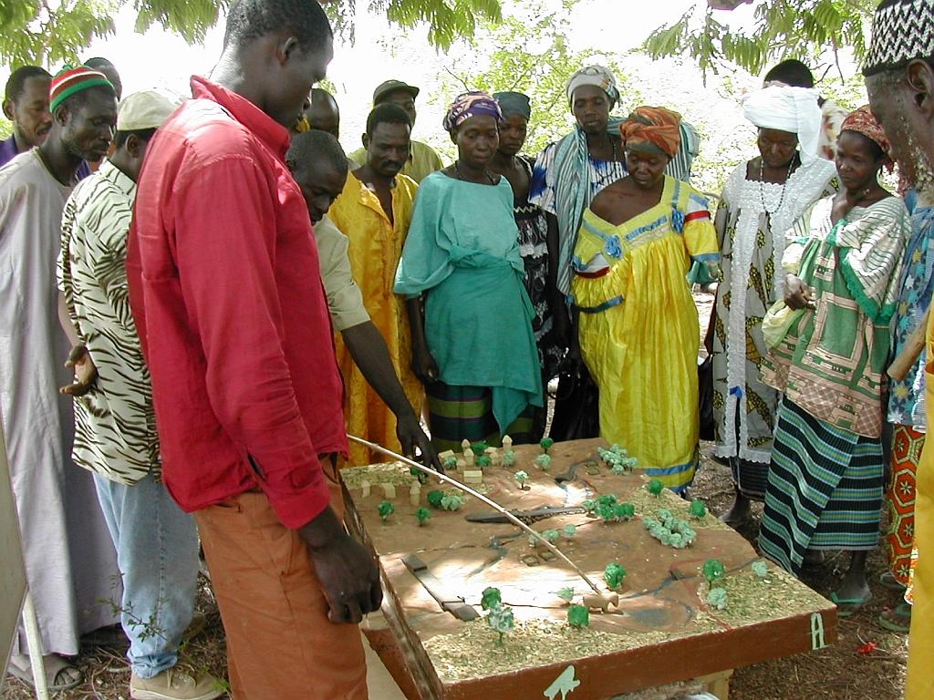
Scale models are an instructional tool that can be used to ensure a common understanding of the characteristics of the lowland area to be developed, give concrete expression to the baseline scenario, and facilitate discussion of the different technical options for the development. Depending on the case at hand, the model shows flooded areas, forested areas, housing, areas given over to pasture or cultivation and the type of scheme that has been chosen with the beneficiaries. Ultimately, a wooden 3D version of the model is produced that is around 80 x 120 centimetres in size. The model is a visual aid that improves communication between the different actors involved and the technical designers during the planning process and development of the lowland area (communities, design agencies and businesses tasked with implementation, etc.). The model is a tool that helps to foster the actors’ ownership of the process, the creation of a shared future vision of the development, and the collaborative management of schemes. It must, however, form part of an overall facilitation approach.
The model is one tool in the toolkit of lowland planning approaches. The process begins with the request by a community and/or local authority for a scheme. A brief for the development scheme is then drawn up jointly by those involved. The project itself starts with a socio-economic study carried out in accordance with the ToR submitted to the community. Approval for the choice of site is obtained in the course of the socio-economic study, which leads into a technical study based on the findings and the summary draft document (SDD). Study findings are fed back to villagers along with the selected scenario. A 3D wooden model is then produced on the basis of the findings and scenario. The other scheme implementation stages are carried out following approval (summary draft document – SDD, drafting of the tender documents – ITD, choice of contractor, works, approval of works completed). The model is subsequently used to move the farming and facility maintenance strategy forward. Two or three village facilitators, who are members of the management committee, are trained in how to handle the model during facilitation sessions.
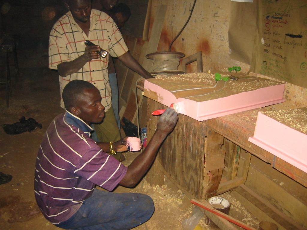
Stages in creating a model: 1)Sketch mapping (involving farmers) and a topographical survey of the area, 2)Precise order placed with the model maker (specification), 3)Provision of a quote by the model maker setting out the costs of the materials and services required (if necessary, a site visit is carried out with the model maker to work through the paper maps of the lowland area), 4)Conversion of the paper maps to the actual scale of the model, 5)Production of the base unit with the basic relief (boards, plywood), 6)Positioning of the technical features to be installed (facilities, roads, irrigated plots, ponds, etc.) and the addition of decorative elements (houses, trees, livestock), 7)Production of a protective shipping case for the model.
Beneficiaries formulate the request, describe and draw sketch maps of the landscape, and use the model in consultation exercises. The consultancy supports the design process, ensures the quality
of on-paper designs for use in constructing the model, and acts as intermediary between the beneficiaries and the woodworker, particularly in terms of converting scales and proportions. The woodworker creates the model according to the plan.
2.3 Арга барилын зурагууд
Медиа галерей
2.5 Арга барил нэвтрүүлсэн улс орон / бүс нутаг / байршил
Улс :
Мали
Улс/аймаг/сум:
Mali
Байршлын дэлгэрэнгүй тодорхойлолт:
Sikasso, Koutiala, Kadiolo and Yorosso, San and Tominian
2.6 Арга барилыг эхлэх, дуусах огноо
Эхлэх жилийг тэмдэглэ:
2005
2.7 Арга барилын төрөл
- төсөл / хөтөлбөр дээр үндэслэсэн
2.8 Арга барилын үндсэн зорилго, зорилтууд
The Approach focused mainly on SLM with other activities.
Encouraging the different actors to enter into negotiations and participate in decision-making on the design and farming of a lowland areas; reduction of conflicts over farming land
The SLM Approach addressed the following problems: lack of participation of the farming community in the development of lowland areas, conflicts over farming land
2.9 Арга барилын хүрээнд хэрэгжсэн Технологи/Технологиудад дэмжсэн эсвэл саад учруулсан нөхцлүүд
Бүтэц зохион байгуулалт
- Хазаарлалт
lack of participation of the farming community in the development of lowland areas
Treatment through the SLM Approach: Creating models when developing lowland areas encourages the different actors involved to enter into negotiations and participate in decision-making on the design and farming of a lowland area.
3. Оролцогч талуудын оролцоо ба үүргүүд
3.1 Арга барилд оролцогч талууд болон тэдгээрийн үүргүүд
- Орон нутгийн газар ашиглагч / орон нутгийн иргэд
- ГТМ-ийн мэргэжилтэн/ хөдөө аж ахуйн зөвлөх
- ТББ
HELVETAS
- Засгийн газар (шийдвэр гаргагч, төлөвлөгч)
3.2 Арга барилын янз бүрийн үе шатанд орон нутгийн газар ашиглагчид / бүлэглэлүүдийг татан оролцуулах
| Орон нутгийн газар ашиглагч / орон нутгийн иргэдийн оролцоо | Хэн оролцсоныг тодорхойлж, үйл ажиллагааг тайлбарлана уу | |
|---|---|---|
| санаачлага/идэвхжүүлэлт | идэвхигүй | |
| Төлөвлөгөө | интерактив | |
| Хэрэгжилт | интерактив | |
| Мониторинг/ үнэлгээ | идэвхигүй | |
| Research | идэвхигүй |
3.4 ГТМ-ийн технологи/технологиуд сонгох шийдвэр
Хэрэгжүүлэх Технологи/Технологиудын сонголтыг хийж шийдвэр гаргасан хүнийг тодорхойлно уу:
- голдуу ГТМ-ийн мэргэжилтнүүд, газар ашиглагчидтай зөвлөлдсөний үндсэн дээр
Тайлбар :
Decisions on the method of implementing the SLM Technology were made by mainly by SLM specialists with consultation of land users
4. Техникийн дэмжлэг, чадавхи бүрдүүлэх, мэдлэгийн менежмент
4.1 Чадавхи бэхжүүлэх/сургалт
Газар эзэмшигчид / бусад оролцогч талуудад сургалт явуулсан уу?
Тийм
Хэн сургалтанд хамрагдсан бэ:
- Газар ашиглагчид
Сургалтын хэлбэр :
- Олон нийтийн уулзалт
- курс дамжаа
Хамрагдсан сэвдүүд:
Local people need to get to grips with the landscape and know how to orientate themselves in the space. The model maker must be well trained and have expertise in concepts of scale, contours and ‘scale exaggerations’
4.2 Зөвлөх үйлчилгээ
Газар ашиглагчдад зөвлөх үйлчилгээ авах боломжтой байдаг уу?
Тийм
Зөвлөх үйлчилгээ үзүүлсэн эсэхийг тогтоо:
- Газар ашиглагчийн талбай дээр
Тодорхойлолт / тайлбар:
Advisory service is quite adequate to ensure the continuation of land conservation activities; the model is facilitated by villagers themselves
4.3 Институцийг бэхжүүлэх (байгууллагын хөгжил)
Арга барилаар дамжуулан институц байгуулагдаж эсвэл бэхжсэн үү?
- Тийм, дунд зэрэг
Байгууллагууд бэхжиж, үүсэн бий болсон түвшин(үүд)-г тодорхойлно уу:
- Орон нутгийн
Дэмжлэгийн төрлийг ялга:
- чадавхи бэхжүүлэх / сургалт
- Тоног төхөөрөмж
4.4 Мониторинг ба үнэлгээ
Мониторинг болон үнэлгээ нь арга барилын хэсэг үү?
Тийм
Тайлбар:
technical aspects were ad hoc monitored by project staff through observations
socio-cultural aspects were ad hoc monitored by project staff through observations
management of Approach aspects were ad hoc monitored by project staff through observations
There were no changes in the Approach as a result of monitoring and evaluation
There were no changes in the Technology as a result of monitoring and evaluation
4.5 Судалгаа
Судалгаа арга барилын хэсэг нь байсан уу?
Тийм
Сэдвийг тодруулна уу:
- Социологи
- Эдийн засаг/ зах зээл
- Экологи
- Технологи
Дэлгэрэнгүй мэдээллийг өгч, хэн судалгаа явуулсныг бичнэ үү:
Helvetas - Swiss Intercooperation
5. Санхүүгийн болон гадаад материаллаг дэмжлэг
5.1 ГТМ-ийн Арга барилын бүрэлдэхүүн хэсгийн жилийн төсөв
Хэрэв жилийн төсөв тодорхойгүй бол хягаарыг тодруулна уу:
- < 2,000
Тайлбар (жнь: санхүүжилтийн гол эх үүсвэр / гол хандивлагчид):
Approach costs were met by the following donors: international non-government: 100.0%
5.2 Газар ашиглагчдад санхүүгийн / материаллаг дэмжлэг үзүүлсэн
Технологи / технологийг хэрэгжүүлэхэд газар ашиглагчид санхүүгийн / материаллаг дэмжлэг авсан уу?
Тийм
5.3 Тодорхой зардлыг даахад чиглэсэн дэмжлэгт (хөдөлмөрийн хүчийг оролцуулаад)
Хэрэв газар ашиглагчийн хөдөлмөрийн хүч чухал байсан бол энэ нь аль хэлбэр байсан:
- сайн дурын
5.4 Кредит
Арга барилын хүрээнд ГТМ-ийн үйл ажиллагаанд зориулж зээлд хамрагдсан уу?
Үгүй
6. Нөлөөллийн дүн шинжилгээ ба дүгнэлт
6.1 Арга барилын нөлөөллүүд
Арга барил нь ГТМ-ийн технологийг хэрэгжүүлж, хадгалахад газар ашиглагчдад тусласан уу?
- Үгүй
- Тийм, бага зэрэг
- Тийм, зарим
- Тийм, их
reduced conflicts over farming land and immediate visibility of the land pattern and spatial issues
Арга барил нь эмзэг бүлгийнхнийг нийгэм, эдийн засгийн хувьд чадавхижуулсан уу?
- Үгүй
- Тийм, бага зэрэг
- Тийм, зарим
- Тийм, их
It is an approach that is more engaging and accessible to all – even the shyest people are able to express themselves.
Did other land users / projects adopt the Approach?
- Үгүй
- Тийм, бага зэрэг
- Тийм, зарим
- Тийм, их
This tool has been used in the regions of Sikasso (Sikasso, Koutiala, Kadiolo and Yorosso) and Ségou (San and Tominian) for all the schemes delivered by HELVETAS Swiss Intercooperation. In total, more than 25 models have been made.
Did the Approach lead to improved livelihoods / human well-being?
- Үгүй
- Тийм, бага зэрэг
- Тийм, зарим
- Тийм, их
The model is tangible, durable and helps reduce social conflict. Involvement and motivation of local people in the design process is ensured. The model enables stakeholders to interpret the landscape and thus helps them in the decision-making process. It is used in consultation exercises to ensure transparency and consensual management in the implementation and evaluation of the scheme.
Did the Approach help to alleviate poverty?
- Үгүй
- Тийм, бага зэрэг
- Тийм, зарим
- Тийм, их
6.2 ГТМ-ийг хэрэгжүүлэх газар ашиглагчидын гол санаачилга
- үйлдвэрлэл нэмэгдсэн
- Ашиг нэмэгдсэн (боломж), зардал-үр ашгийн харьцаа сайжирсан
- төлбөр / татаас
- Байгаль орчны ухамсар
- well-being and livelihoods improvement
6.3 Арга барилын үйл ажиллагааны тогтвортой байдал
Газар ашиглагчид арга барилаар дамжуулан хэрэгжүүлсэн арга хэмжээг тогтвортой хадгалж чадах уу (гадны дэмжлэггүйгээр)?
- Тийм
6.4 Арга барилын тогтвортой/давуу тал/боломжууд
| Эмхэтгэгч, бусад мэдээлэл өгсөн хүмүүсийн өнцгөөс тодорхойлсон давуу тал/боломжууд |
|---|
| The results are immediate and manifest as: reduced conflicts over farming the land in question; the immediate visibility of the land pattern and spatial issues; the involvement and motivation of local people in the design process; more inclusive decisions and the initiation of social dialogue on the scheme; an approach that is more engaging and accessible to all – even the shyest people are able to express themselves. (How to sustain/ enhance this strength: The approach must be participatory; it should not exclude any sector of society. In this respect, young people and women prove to be very good facilitators, with the model helping them to present the subject matter in a lively and engaging way.) |
|
The model enables stakeholders to interpret the landscape and thus helps them in the decision-making process. It is used in consultation exercises to ensure transparency and consensual management in the implementation and evaluation of the scheme. (How to sustain/ enhance this strength: To use the model, all that is required is for it to be transported to the meeting/facilitation space, removed from its case and placed at table height or even on the ground. The facilitator then introduces the project, indicating the landmarks and cardinal directions. This serves as the basis for discussion. Local people need to get to grips with the landscape and know how to orientate themselves in the space. The model maker must be well trained and have expertise in concepts of scale, contours and ‘scale exaggerations’. They must have an artist’s eye. ) |
| The model is tangible, durable and helps reduce social conflict. It also serves as a support for meetings with visitors. It is facilitated by villagers themselves. |
6.5 Арга барилын дутагдалтай/сул тал/аюул болон тэдгээрийн хэрхэн даван туулах арга замууд
| Эмхэтгэгч, бусад мэдээлэл өгсөн хүмүүсийн өнцгөөс тодорхойлсон сул тал/ дутагдал/ эрсдэл | Тэдгээрийг хэрхэн даван туулах вэ? |
|---|---|
| Some experts from technical consultancies have the tendency to take over from the beneficiaries. Other public sector experts move things forward as quickly as possible and fail to take into account villagers’ contributions. |
To ensure that people are not left frustrated and, as a result, participate less in the process, it is important to give them the opportunity to express their views. |
| Modifications may be required once the model is completed. Integrating these corrections can prove difficult (engaging the same provider and carrying out alterations without diminishing the appearance of the model). |
7. Суурь мэдээлэл болон холбоосууд
7.1 Мэдээллийн эх үүсвэр/аргууд
- Хээрийн уулзалт, судалгаа
- Газар ашиглагчтай хийсэн ярилцлага
7.2 Холбогдох бүтээлийн ишлэл
Гарчиг, зохиогч, он, ISBN:
Intercooperation, Délégation au Sahel (n.d.): Capitalisation d’éxperience. Eau, terre, communautés. La maquette pédagogique transportable dans l’aménagement des bas-fonds. Un outil pour les practiciens. [Delegation to the Sahel (n.d.): Capitalising on experiences. Water, land, communities. The portable instructional model for developing lowland schemes. A tool for practitioners.]
Хаанаас авч болох вэ? Зардал?
http://agriwaterpedia.info/wiki/Main_Page
Гарчиг, зохиогч, он, ISBN:
Intercooperation, Délégation au Sahel (2009): Gestion des ressources naturelles: les acteurs s’engagent pour une gestion concertée et pacifique de leurs resources. [Delegation to the Sahel (2009): Management of natural resources – actors engage in the collaborative and peaceful management of their resources.]
Гарчиг, зохиогч, он, ISBN:
Good Practices in Soil and Water Conservation. A contribution to adaptation and farmers´ resilience towards climate change in the Sahel. Published by GIZ in 2012.
Хаанаас авч болох вэ? Зардал?
http://agrwaterpedia.info/wiki/Main_Page
Холбоос ба модулууд
Бүгдийг харуулах Бүгдийг хаахХолбоосууд
Холбоос байхгүй байна
Модулууд
Модуль байхгүй байна