Creating scale models for the development of lowland areas and the participation of the farming community [Mali]
- Criação:
- Atualização:
- Compilador/a: Dieter Nill
- Editor: –
- Revisor: Laura Ebneter
Elaboration des maquettes pour l’aménagement des bas-fonds et la participation paysanne
approaches_2500 - Mali
- Resumo completo em PDF
- Resumo completo em PDF para impressão
- Resumo completo no navegador
- Resumo completo (sem formatação)
- Creating scale models for the development of lowland areas and the participation of the farming community: 7 de Junho de 2017 (inactive)
- Creating scale models for the development of lowland areas and the participation of the farming community: 7 de Junho de 2017 (inactive)
- Creating scale models for the development of lowland areas and the participation of the farming community: 7 de Junho de 2017 (inactive)
- Creating scale models for the development of lowland areas and the participation of the farming community: 12 de Junho de 2017 (public)
Veja as seções
Expandir tudo Recolher tudo1. Informação geral
1.2 Detalhes do contato das pessoas capacitadas e instituições envolvidas na avaliação e documentação da abordagem
Especialista em GST:
Keita Lassana
lassana.keita@helvetas.org
HELVETAS - Swiss Intercooperation
Mali
Especialista em GST:
Dembélé Célestin
celestin.dembele@helvetas.org
HELVETAS - Swiss Intercooperation
Mali
Especialista em GST:
Dacko Maïga Rosaline
rosaline.dacko@helvetas.org
HELVETAS - Swiss Intercooperation
Mali
Nome da(s) instituição(ões) que facilitou(ram) a documentação/avaliação da Abordagem (se relevante)
HELVETAS (Swiss Intercooperation)Nome da(s) instituição(ões) que facilitou(ram) a documentação/avaliação da Abordagem (se relevante)
Deutsche Gesellschaft für Internationale Zusammenarbeit (GIZ) GmbH (GIZ) - Alemanha1.3 Condições em relação ao uso da informação documentada através de WOCAT
Quando os dados foram compilados (no campo)?
01/07/2012
O/a compilador/a e a(s) pessoa(s) capacitada(s) aceitam as condições relativas ao uso de dados documentados através da WOCAT:
Sim
2. Descrição da abordagem de GST
2.1 Descrição curta da abordagem
Creating models when developing lowland areas encourages the different actors involved to enter into negotiations and participate in decision-making on the design and farming of a lowland area.
2.2 Descrição detalhada da abordagem
Descrição detalhada da abordagem:
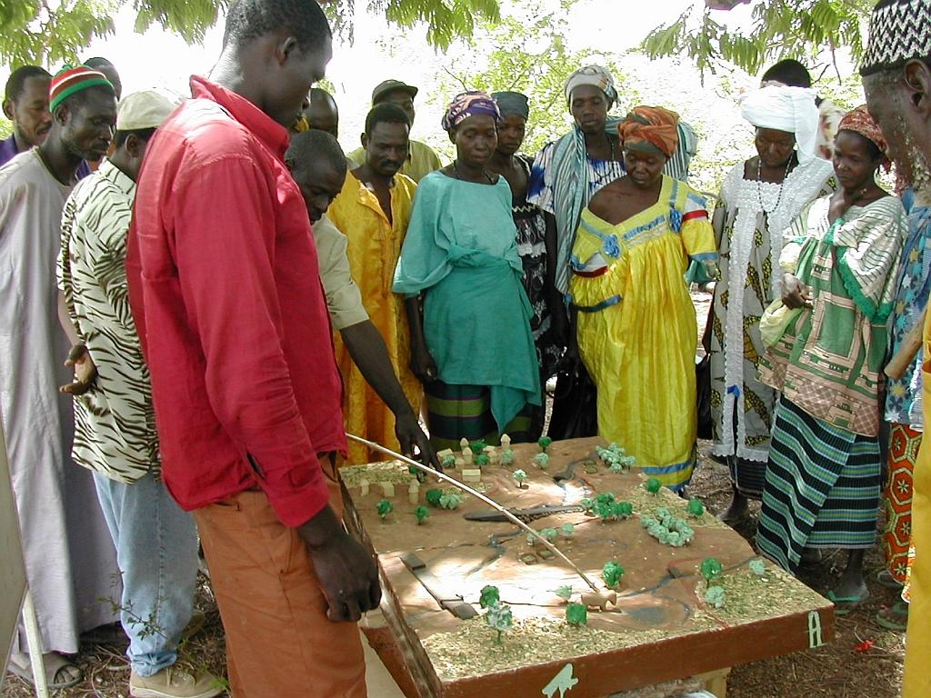
Scale models are an instructional tool that can be used to ensure a common understanding of the characteristics of the lowland area to be developed, give concrete expression to the baseline scenario, and facilitate discussion of the different technical options for the development. Depending on the case at hand, the model shows flooded areas, forested areas, housing, areas given over to pasture or cultivation and the type of scheme that has been chosen with the beneficiaries. Ultimately, a wooden 3D version of the model is produced that is around 80 x 120 centimetres in size. The model is a visual aid that improves communication between the different actors involved and the technical designers during the planning process and development of the lowland area (communities, design agencies and businesses tasked with implementation, etc.). The model is a tool that helps to foster the actors’ ownership of the process, the creation of a shared future vision of the development, and the collaborative management of schemes. It must, however, form part of an overall facilitation approach.
The model is one tool in the toolkit of lowland planning approaches. The process begins with the request by a community and/or local authority for a scheme. A brief for the development scheme is then drawn up jointly by those involved. The project itself starts with a socio-economic study carried out in accordance with the ToR submitted to the community. Approval for the choice of site is obtained in the course of the socio-economic study, which leads into a technical study based on the findings and the summary draft document (SDD). Study findings are fed back to villagers along with the selected scenario. A 3D wooden model is then produced on the basis of the findings and scenario. The other scheme implementation stages are carried out following approval (summary draft document – SDD, drafting of the tender documents – ITD, choice of contractor, works, approval of works completed). The model is subsequently used to move the farming and facility maintenance strategy forward. Two or three village facilitators, who are members of the management committee, are trained in how to handle the model during facilitation sessions.
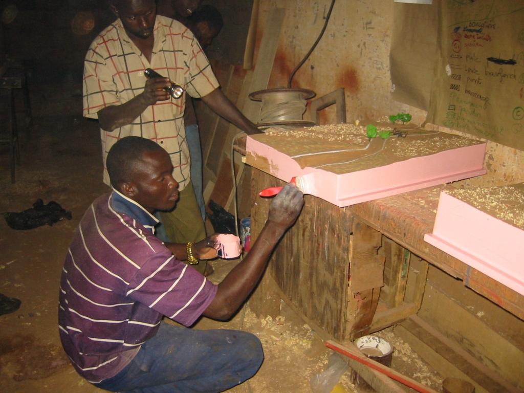
Stages in creating a model: 1)Sketch mapping (involving farmers) and a topographical survey of the area, 2)Precise order placed with the model maker (specification), 3)Provision of a quote by the model maker setting out the costs of the materials and services required (if necessary, a site visit is carried out with the model maker to work through the paper maps of the lowland area), 4)Conversion of the paper maps to the actual scale of the model, 5)Production of the base unit with the basic relief (boards, plywood), 6)Positioning of the technical features to be installed (facilities, roads, irrigated plots, ponds, etc.) and the addition of decorative elements (houses, trees, livestock), 7)Production of a protective shipping case for the model.
Beneficiaries formulate the request, describe and draw sketch maps of the landscape, and use the model in consultation exercises. The consultancy supports the design process, ensures the quality
of on-paper designs for use in constructing the model, and acts as intermediary between the beneficiaries and the woodworker, particularly in terms of converting scales and proportions. The woodworker creates the model according to the plan.
2.3 Fotos da abordagem
Galeria de Mídias
2.5 País/região/locais onde a abordagem foi aplicada
País:
Mali
Região/Estado/Província:
Mali
Especificação adicional de localização:
Sikasso, Koutiala, Kadiolo and Yorosso, San and Tominian
2.6 Datas de início e término da abordagem
Indique o ano de início:
2005
2.7 Tipo de abordagem
- Baseado em projeto/programa
2.8 Principais metas/objetivos da abordagem
The Approach focused mainly on SLM with other activities.
Encouraging the different actors to enter into negotiations and participate in decision-making on the design and farming of a lowland areas; reduction of conflicts over farming land
The SLM Approach addressed the following problems: lack of participation of the farming community in the development of lowland areas, conflicts over farming land
2.9 Condição que propiciam ou inibem a implementação de tecnologia/tecnologias aplicada(s) segundo a abordagem
Quadro institucional
- Inibitivo
lack of participation of the farming community in the development of lowland areas
Treatment through the SLM Approach: Creating models when developing lowland areas encourages the different actors involved to enter into negotiations and participate in decision-making on the design and farming of a lowland area.
3. Participação e papel das partes interessadas envolvidas
3.1 Partes interessadas envolvidas na abordagem e seus papéis
- Usuários de terra/comunidades locais
- Especialistas em GST/ consultor agrícola
- Organização não governamental
HELVETAS
- Governo nacional (planejadores, responsáveis pelas decisões)
3.2 Envolvimento do usuários de terra/comunidades locais nas diferentes fases da abordagem
| Envolvimento do usuários de terra/comunidades locais | Especifique quem estava envolvido e descreva as atividades | |
|---|---|---|
| Iniciação/motivação | Passivo | |
| Planejamento | Participativo | |
| Implementação | Participativo | |
| Monitoramento/avaliação | Passivo | |
| Research | Passivo |
3.4 Decisão sobre a seleção de tecnologia/tecnologias de GST
Especifique quem decidiu sobre a seleção de tecnologia/tecnologias a serem implementadas:
- Principalmente especialistas em GST, após consulta com usuários da terra
Explique:
Decisions on the method of implementing the SLM Technology were made by mainly by SLM specialists with consultation of land users
4. Suporte técnico, reforço das capacidades e gestão do conhecimento
4.1 Reforço das capacidades/ formação
Foi oferecida formação aos usuários da terra/outras partes interessadas?
Sim
Especifique quem foi capacitado:
- Usuários de terra
Tipo de formação:
- Reuniões públicas
- Cursos
Assuntos abordados:
Local people need to get to grips with the landscape and know how to orientate themselves in the space. The model maker must be well trained and have expertise in concepts of scale, contours and ‘scale exaggerations’
4.2 Serviço de consultoria
Os usuários de terra têm acesso a um serviço de consultoria?
Sim
Especifique se foi oferecido serviço de consultoria:
- nas áreas dos usuários da terra
Descreva/comentários:
Advisory service is quite adequate to ensure the continuation of land conservation activities; the model is facilitated by villagers themselves
4.3 Fortalecimento da instituição (desenvolvimento organizacional)
As instituições foram fortalecidas ou estabelecidas através da abordagem?
- Sim, moderadamente
Especifique a que nível (níveis) as instituições foram fortalecidas ou estabelecidas:
- Local
Especifique o tipo de apoio:
- Reforço das capacidades/ formação
- Equipamento
4.4 Monitoramento e avaliação
Monitoramento e avaliação são partes da abordagem?
Sim
Comentários:
technical aspects were ad hoc monitored by project staff through observations
socio-cultural aspects were ad hoc monitored by project staff through observations
management of Approach aspects were ad hoc monitored by project staff through observations
There were no changes in the Approach as a result of monitoring and evaluation
There were no changes in the Technology as a result of monitoring and evaluation
4.5 Pesquisa
A pesquisa foi parte da abordagem?
Sim
Especifique os tópicos:
- Sociologia
- Economia/Marketing
- Ecologia
- Tecnologia
Dê mais detalhes e indique quem realizou a pesquisa:
Helvetas - Swiss Intercooperation
5. Financiamento e apoio material externo
5.1 Orçamento anual para o componente de GST da abordagem
Caso o orçamento exato seja desconhecido, indique a faixa:
- < 2.000
Comentários (p. ex. principais fontes de recursos/principais doadores):
Approach costs were met by the following donors: international non-government: 100.0%
5.2 Apoio financeiro/material concedido aos usuários da terra
Os usuários da terra receberam apoio financeiro/material para a implementação de tecnologia/tecnologias?
Sim
5.3 Subsídios para entradas específicas (incluindo mão-de-obra)
Se a mão-de-obra pelos usuários da terra foi uma entrada substancial, isso foi:
- Voluntário
5.4 Crédito
Foi concedido crédito segundo a abordagem para atividades de GST?
Não
6. Análise de impactos e declarações finais
6.1 Impactos da abordagem
A abordagem auxiliou os usuários da terra a implementar e manter as tecnologias de GST?
- Não
- Sim, pouco
- Sim, moderadamente
- Sim, significativamente
reduced conflicts over farming land and immediate visibility of the land pattern and spatial issues
A abordagem concedeu autonomia aos grupos social e economicamente desfavorecidos?
- Não
- Sim, pouco
- Sim, moderadamente
- Sim, significativamente
It is an approach that is more engaging and accessible to all – even the shyest people are able to express themselves.
Did other land users / projects adopt the Approach?
- Não
- Sim, pouco
- Sim, moderadamente
- Sim, significativamente
This tool has been used in the regions of Sikasso (Sikasso, Koutiala, Kadiolo and Yorosso) and Ségou (San and Tominian) for all the schemes delivered by HELVETAS Swiss Intercooperation. In total, more than 25 models have been made.
Did the Approach lead to improved livelihoods / human well-being?
- Não
- Sim, pouco
- Sim, moderadamente
- Sim, significativamente
The model is tangible, durable and helps reduce social conflict. Involvement and motivation of local people in the design process is ensured. The model enables stakeholders to interpret the landscape and thus helps them in the decision-making process. It is used in consultation exercises to ensure transparency and consensual management in the implementation and evaluation of the scheme.
Did the Approach help to alleviate poverty?
- Não
- Sim, pouco
- Sim, moderadamente
- Sim, significativamente
6.2 Principal motivação dos usuários da terra para implementar a GST
- Produção aumentada
- Lucro (lucrabilidade) aumentado, melhora da relação custo-benefício
- Pagamentos/subsídios
- Consciência ambiental
- well-being and livelihoods improvement
6.3 Atividades de sustentabilidade de abordagem
Os usuários da terra podem manter o que foi implementado através da abordagem (sem apoio externo)?
- Sim
6.4 Pontos fortes/vantagens da abordagem
| Pontos fortes/vantagens/oportunidades na visão do/a compilador/a ou de outra pessoa capacitada |
|---|
| The results are immediate and manifest as: reduced conflicts over farming the land in question; the immediate visibility of the land pattern and spatial issues; the involvement and motivation of local people in the design process; more inclusive decisions and the initiation of social dialogue on the scheme; an approach that is more engaging and accessible to all – even the shyest people are able to express themselves. (How to sustain/ enhance this strength: The approach must be participatory; it should not exclude any sector of society. In this respect, young people and women prove to be very good facilitators, with the model helping them to present the subject matter in a lively and engaging way.) |
|
The model enables stakeholders to interpret the landscape and thus helps them in the decision-making process. It is used in consultation exercises to ensure transparency and consensual management in the implementation and evaluation of the scheme. (How to sustain/ enhance this strength: To use the model, all that is required is for it to be transported to the meeting/facilitation space, removed from its case and placed at table height or even on the ground. The facilitator then introduces the project, indicating the landmarks and cardinal directions. This serves as the basis for discussion. Local people need to get to grips with the landscape and know how to orientate themselves in the space. The model maker must be well trained and have expertise in concepts of scale, contours and ‘scale exaggerations’. They must have an artist’s eye. ) |
| The model is tangible, durable and helps reduce social conflict. It also serves as a support for meetings with visitors. It is facilitated by villagers themselves. |
6.5 Pontos fracos, desvantagens da tecnologia e formas de superá-los
| Pontos fracos/vantagens/riscos na visão do/a compilador/a ou de outra pessoa capacitada | Como eles podem ser superados? |
|---|---|
| Some experts from technical consultancies have the tendency to take over from the beneficiaries. Other public sector experts move things forward as quickly as possible and fail to take into account villagers’ contributions. |
To ensure that people are not left frustrated and, as a result, participate less in the process, it is important to give them the opportunity to express their views. |
| Modifications may be required once the model is completed. Integrating these corrections can prove difficult (engaging the same provider and carrying out alterations without diminishing the appearance of the model). |
7. Referências e links
7.1 Métodos/fontes de informação
- visitas de campo, pesquisas de campo
- entrevistas com usuários de terras
7.2 Referências às publicações disponíveis
Título, autor, ano, ISBN:
Intercooperation, Délégation au Sahel (n.d.): Capitalisation d’éxperience. Eau, terre, communautés. La maquette pédagogique transportable dans l’aménagement des bas-fonds. Un outil pour les practiciens. [Delegation to the Sahel (n.d.): Capitalising on experiences. Water, land, communities. The portable instructional model for developing lowland schemes. A tool for practitioners.]
Disponível de onde? Custos?
http://agriwaterpedia.info/wiki/Main_Page
Título, autor, ano, ISBN:
Intercooperation, Délégation au Sahel (2009): Gestion des ressources naturelles: les acteurs s’engagent pour une gestion concertée et pacifique de leurs resources. [Delegation to the Sahel (2009): Management of natural resources – actors engage in the collaborative and peaceful management of their resources.]
Título, autor, ano, ISBN:
Good Practices in Soil and Water Conservation. A contribution to adaptation and farmers´ resilience towards climate change in the Sahel. Published by GIZ in 2012.
Disponível de onde? Custos?
http://agrwaterpedia.info/wiki/Main_Page
Links e módulos
Expandir tudo Recolher tudoLinks
Não há links
Módulos
Não há módulos