Creating scale models for the development of lowland areas and the participation of the farming community [Мали]
- Создание:
- Обновить:
- Составитель: Dieter Nill
- Редактор: –
- Рецензент: Laura Ebneter
Elaboration des maquettes pour l’aménagement des bas-fonds et la participation paysanne
approaches_2500 - Мали
- Полная аннотация в формате PDF
- Полная аннотация в формате PDF для вывода на печать
- Полная аннотация в формате интернет-страницы
- Полная аннотация (неотформатированно)
- Creating scale models for the development of lowland areas and the participation of the farming community: 12 июня 2017 г. (public)
- Creating scale models for the development of lowland areas and the participation of the farming community: 7 июня 2017 г. (inactive)
- Creating scale models for the development of lowland areas and the participation of the farming community: 7 июня 2017 г. (inactive)
- Creating scale models for the development of lowland areas and the participation of the farming community: 7 июня 2017 г. (inactive)
Просмотреть разделы
Развернуть все Свернуть все1. Общая информация
1.2 Контактные данные специалистов и организаций, участвующих в описании и оценке Подхода
Специалист по УЗП:
Keita Lassana
lassana.keita@helvetas.org
HELVETAS - Swiss Intercooperation
Мали
Специалист по УЗП:
Dembélé Célestin
celestin.dembele@helvetas.org
HELVETAS - Swiss Intercooperation
Мали
Специалист по УЗП:
Dacko Maïga Rosaline
rosaline.dacko@helvetas.org
HELVETAS - Swiss Intercooperation
Мали
Название организации (-ий), содействовавших документированию/оценке Подхода (если применимо)
HELVETAS (Swiss Intercooperation)Название организации (-ий), содействовавших документированию/оценке Подхода (если применимо)
Deutsche Gesellschaft für Internationale Zusammenarbeit (GIZ) - Германия1.3 Условия, регламентирующие использование собранных ВОКАТ данных
Когда были собраны данные (на местах)?
01/07/2012
Составитель и ответственный/-ые специалист(-ы) согласны с условиями, регламентирующими использование собранных ВОКАТ данных:
Да
2. Описание Подхода УЗП
2.1 Краткое описание Подхода
Creating models when developing lowland areas encourages the different actors involved to enter into negotiations and participate in decision-making on the design and farming of a lowland area.
2.2 Подробное описание Подхода
Подробное описание Подхода:
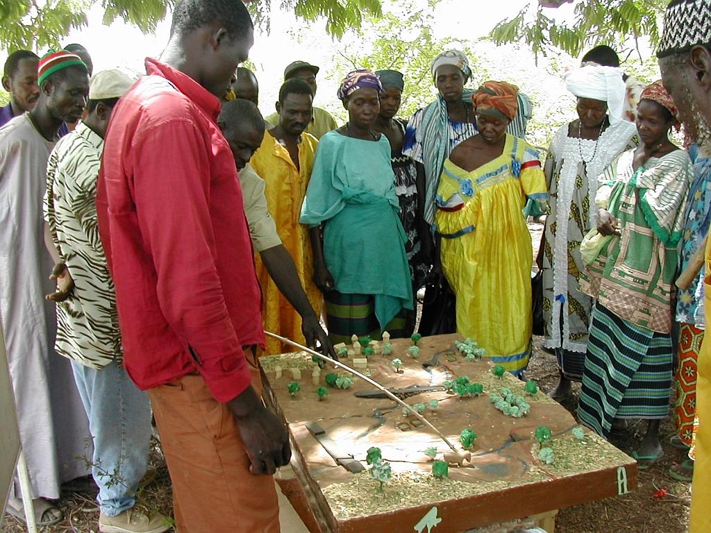
Scale models are an instructional tool that can be used to ensure a common understanding of the characteristics of the lowland area to be developed, give concrete expression to the baseline scenario, and facilitate discussion of the different technical options for the development. Depending on the case at hand, the model shows flooded areas, forested areas, housing, areas given over to pasture or cultivation and the type of scheme that has been chosen with the beneficiaries. Ultimately, a wooden 3D version of the model is produced that is around 80 x 120 centimetres in size. The model is a visual aid that improves communication between the different actors involved and the technical designers during the planning process and development of the lowland area (communities, design agencies and businesses tasked with implementation, etc.). The model is a tool that helps to foster the actors’ ownership of the process, the creation of a shared future vision of the development, and the collaborative management of schemes. It must, however, form part of an overall facilitation approach.
The model is one tool in the toolkit of lowland planning approaches. The process begins with the request by a community and/or local authority for a scheme. A brief for the development scheme is then drawn up jointly by those involved. The project itself starts with a socio-economic study carried out in accordance with the ToR submitted to the community. Approval for the choice of site is obtained in the course of the socio-economic study, which leads into a technical study based on the findings and the summary draft document (SDD). Study findings are fed back to villagers along with the selected scenario. A 3D wooden model is then produced on the basis of the findings and scenario. The other scheme implementation stages are carried out following approval (summary draft document – SDD, drafting of the tender documents – ITD, choice of contractor, works, approval of works completed). The model is subsequently used to move the farming and facility maintenance strategy forward. Two or three village facilitators, who are members of the management committee, are trained in how to handle the model during facilitation sessions.
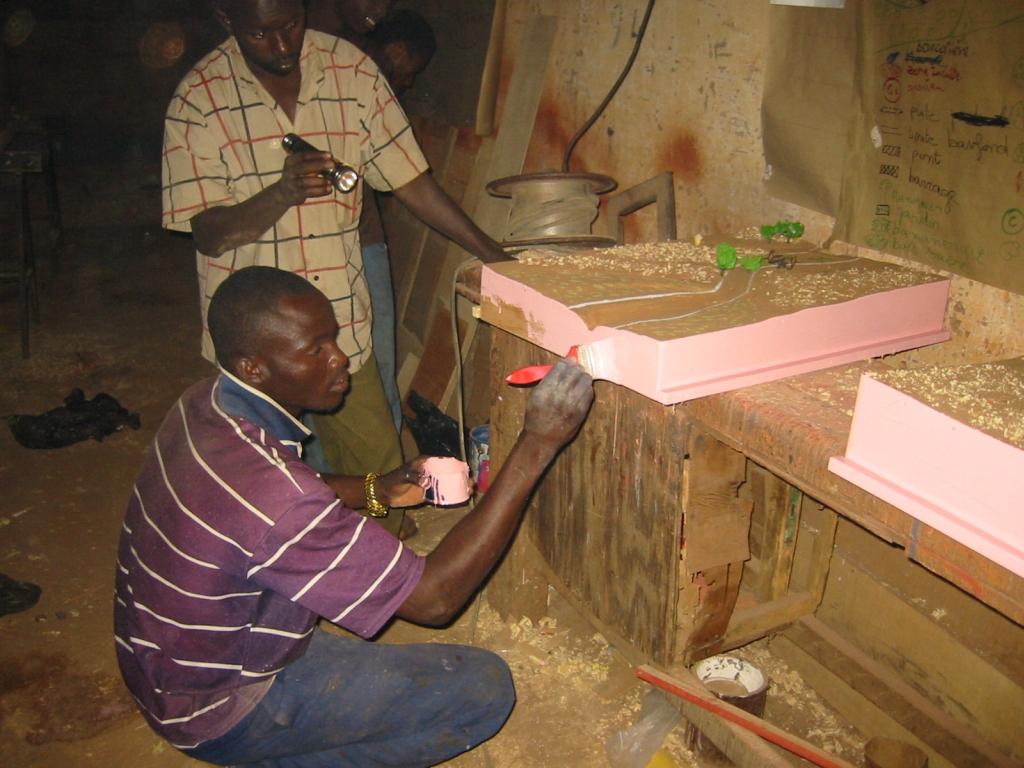
Stages in creating a model: 1)Sketch mapping (involving farmers) and a topographical survey of the area, 2)Precise order placed with the model maker (specification), 3)Provision of a quote by the model maker setting out the costs of the materials and services required (if necessary, a site visit is carried out with the model maker to work through the paper maps of the lowland area), 4)Conversion of the paper maps to the actual scale of the model, 5)Production of the base unit with the basic relief (boards, plywood), 6)Positioning of the technical features to be installed (facilities, roads, irrigated plots, ponds, etc.) and the addition of decorative elements (houses, trees, livestock), 7)Production of a protective shipping case for the model.
Beneficiaries formulate the request, describe and draw sketch maps of the landscape, and use the model in consultation exercises. The consultancy supports the design process, ensures the quality
of on-paper designs for use in constructing the model, and acts as intermediary between the beneficiaries and the woodworker, particularly in terms of converting scales and proportions. The woodworker creates the model according to the plan.
2.3 Фотографии, иллюстрирующие Подход
Медиа-галерея
2.5 Страна/ регион/ место, где применялся Подход
Страна:
Мали
Административная единица (Район/Область):
Mali
Более точная привязка места:
Sikasso, Koutiala, Kadiolo and Yorosso, San and Tominian
2.6 Даты начала и окончания реализации Подхода
Год начала реализации:
2005
2.7 Тип Подхода
- в рамках проекта/ программы
2.8 Каковы цели/ задачи Подхода
The Approach focused mainly on SLM with other activities.
Encouraging the different actors to enter into negotiations and participate in decision-making on the design and farming of a lowland areas; reduction of conflicts over farming land
The SLM Approach addressed the following problems: lack of participation of the farming community in the development of lowland areas, conflicts over farming land
2.9 Условия содействующие применению Технологии/ Технологий в рамках Подхода или затрудняющие его
Институциональные условия
- затрудняют
lack of participation of the farming community in the development of lowland areas
Treatment through the SLM Approach: Creating models when developing lowland areas encourages the different actors involved to enter into negotiations and participate in decision-making on the design and farming of a lowland area.
3. Участие и распределение ролей заинтересованных сторон
3.1 Заинтересованные стороны, участвующие в реализации Подхода и их роли
- местные землепользователи/ местные сообщества
- эксперты по УЗП/ сельскому хозяйству
- общественные организации
HELVETAS
- государственные власти (отвечающие за планирование или принятие решений)
3.2 Участие местных землепользователей/ местных сообществ на разных стадиях реализации Подхода
| Участие местных землепользователей/ местных сообществ | Перечислите участников и опишите их вовлеченность | |
|---|---|---|
| инициирование/ мотивация | пассивное | |
| планирование | интерактивное | |
| выполнение | интерактивное | |
| мониторинг/ оценка | пассивное | |
| Research | пассивное |
3.4 Принятие решений по выбору Технологии/ Технологий УЗП
Укажите, кто принимал решение по выбору применяемой Технологии/ Технологий:
- преимущественно специалисты по УЗП после консультаций с землепользователями
Поясните:
Decisions on the method of implementing the SLM Technology were made by mainly by SLM specialists with consultation of land users
4. Техническая поддержка, повышение компетенций и управление знаниями
4.1 Повышение компетенций/ обучение
Проводилось ли обучение землепользователей/ других заинтересованных лиц?
Да
Укажите, кто проходил обучение:
- землепользователи
Тип обучения:
- общие собрания
- курсы
Рассматриваемые темы:
Local people need to get to grips with the landscape and know how to orientate themselves in the space. The model maker must be well trained and have expertise in concepts of scale, contours and ‘scale exaggerations’
4.2 Консультационные услуги
Есть ли у землепользователей возможность получать консультации?
Да
Укажите, где именно оказываются консультационные услуги:
- на полях землепользователей
Описание/ комментарий:
Advisory service is quite adequate to ensure the continuation of land conservation activities; the model is facilitated by villagers themselves
4.3 Институциональная (организационная) поддержка
В ходе реализации Подхода были ли организованы новые институциональные структуры или поддержаны уже существующие?
- да, умеренно
Укажите уровень, на котором структуры были укреплены или вновь созданы:
- местные
Укажите тип поддержки:
- повышение компетенций/ обучение
- оборудование
4.4 Мониторинг и оценка
Являются ли мониторинг и оценка частью Подхода?
Да
Комментарии:
technical aspects were ad hoc monitored by project staff through observations
socio-cultural aspects were ad hoc monitored by project staff through observations
management of Approach aspects were ad hoc monitored by project staff through observations
There were no changes in the Approach as a result of monitoring and evaluation
There were no changes in the Technology as a result of monitoring and evaluation
4.5 Научные исследования
Были ли научные исследования частью Подхода?
Да
Укажите темы исследований:
- социология
- экономика / маркетинг
- экология
- технология
Напишите подробнее и назовите тех, кто выполнял исследования:
Helvetas - Swiss Intercooperation
5. Финансирование и внешняя материальная поддержка
5.1 Годовой бюджет мероприятий по УЗП в рамках Подхода
Если точный годовой бюжет неизвестен, укажите примерный диапазон затрат:
- < 2000
Комментарий (например, основные источники финансирования/ ключевые доноры):
Approach costs were met by the following donors: international non-government: 100.0%
5.2 Финансирование и внешняя материальная поддержка, предоставляемая землепользователям
Предоставлялась ли землепользователям финансовая/ материальная поддержка для применения Технологии /Технологий?
Да
5.3 Субсидии на отдельные затраты (включая оплату труда)
Если труд землепользователя был существенным вкладом, укажите, был ли этот вклад:
- добровольный
5.4 Кредитование
Предоставлялись ли в рамках Подхода кредиты на мероприятия УЗП?
Нет
6. Анализ влияния и заключительные положения
6.1 Влияние Подхода
Сумел ли Подход помочь землепользователям внедрить и поддерживать технологии УЗП?
- Нет
- Да, немного
- Да, умеренно
- Да, существенно
reduced conflicts over farming land and immediate visibility of the land pattern and spatial issues
Сумел ли Подход расширить возможности социально и экономически уязвимых групп?
- Нет
- Да, немного
- Да, умеренно
- Да, существенно
It is an approach that is more engaging and accessible to all – even the shyest people are able to express themselves.
Did other land users / projects adopt the Approach?
- Нет
- Да, немного
- Да, умеренно
- Да, существенно
This tool has been used in the regions of Sikasso (Sikasso, Koutiala, Kadiolo and Yorosso) and Ségou (San and Tominian) for all the schemes delivered by HELVETAS Swiss Intercooperation. In total, more than 25 models have been made.
Did the Approach lead to improved livelihoods / human well-being?
- Нет
- Да, немного
- Да, умеренно
- Да, существенно
The model is tangible, durable and helps reduce social conflict. Involvement and motivation of local people in the design process is ensured. The model enables stakeholders to interpret the landscape and thus helps them in the decision-making process. It is used in consultation exercises to ensure transparency and consensual management in the implementation and evaluation of the scheme.
Did the Approach help to alleviate poverty?
- Нет
- Да, немного
- Да, умеренно
- Да, существенно
6.2 Основные причины, побуждающие землепользователей внедрять УЗП
- рост продуктивности
- рост прибыли (доходности) и рентабельности
- материальное стимулирование/ субсидии
- экологическая сознательность
- well-being and livelihoods improvement
6.3 Долгосрочная устойчивость мероприятий в рамках Подхода
Могут ли землепользователи самостоятельно (без внешней поддержки) продолжать применение того, что было реализовано в рамках Подхода?
- да
6.4 Сильные стороны/ преимущества Подхода
| Сильные стороны/ преимущества/ возможности по мнению составителя или других ключевых специалистов |
|---|
| The results are immediate and manifest as: reduced conflicts over farming the land in question; the immediate visibility of the land pattern and spatial issues; the involvement and motivation of local people in the design process; more inclusive decisions and the initiation of social dialogue on the scheme; an approach that is more engaging and accessible to all – even the shyest people are able to express themselves. (How to sustain/ enhance this strength: The approach must be participatory; it should not exclude any sector of society. In this respect, young people and women prove to be very good facilitators, with the model helping them to present the subject matter in a lively and engaging way.) |
|
The model enables stakeholders to interpret the landscape and thus helps them in the decision-making process. It is used in consultation exercises to ensure transparency and consensual management in the implementation and evaluation of the scheme. (How to sustain/ enhance this strength: To use the model, all that is required is for it to be transported to the meeting/facilitation space, removed from its case and placed at table height or even on the ground. The facilitator then introduces the project, indicating the landmarks and cardinal directions. This serves as the basis for discussion. Local people need to get to grips with the landscape and know how to orientate themselves in the space. The model maker must be well trained and have expertise in concepts of scale, contours and ‘scale exaggerations’. They must have an artist’s eye. ) |
| The model is tangible, durable and helps reduce social conflict. It also serves as a support for meetings with visitors. It is facilitated by villagers themselves. |
6.5 Слабые стороны/ недостатки Подхода и пути их преодоления
| Слабые стороны/ недостатки/ риски по мнению составителя или ответственных специалистов | Возможные пути их преодоления/снижения? |
|---|---|
| Some experts from technical consultancies have the tendency to take over from the beneficiaries. Other public sector experts move things forward as quickly as possible and fail to take into account villagers’ contributions. |
To ensure that people are not left frustrated and, as a result, participate less in the process, it is important to give them the opportunity to express their views. |
| Modifications may be required once the model is completed. Integrating these corrections can prove difficult (engaging the same provider and carrying out alterations without diminishing the appearance of the model). |
7. Справочные материалы и ссылки
7.1 Методы сбора/источники информации
- выезды на места, полевые обследования
- опросы землепользователей
7.2 Ссылки на опубликованные материалы
Название, автор, год публикации, ISBN:
Intercooperation, Délégation au Sahel (n.d.): Capitalisation d’éxperience. Eau, terre, communautés. La maquette pédagogique transportable dans l’aménagement des bas-fonds. Un outil pour les practiciens. [Delegation to the Sahel (n.d.): Capitalising on experiences. Water, land, communities. The portable instructional model for developing lowland schemes. A tool for practitioners.]
Где опубликовано? Стоимость?
http://agriwaterpedia.info/wiki/Main_Page
Название, автор, год публикации, ISBN:
Intercooperation, Délégation au Sahel (2009): Gestion des ressources naturelles: les acteurs s’engagent pour une gestion concertée et pacifique de leurs resources. [Delegation to the Sahel (2009): Management of natural resources – actors engage in the collaborative and peaceful management of their resources.]
Название, автор, год публикации, ISBN:
Good Practices in Soil and Water Conservation. A contribution to adaptation and farmers´ resilience towards climate change in the Sahel. Published by GIZ in 2012.
Где опубликовано? Стоимость?
http://agrwaterpedia.info/wiki/Main_Page
Ссылки и модули
Развернуть все Свернуть всеСсылки
Нет ссылок
Модули
Нет модулей