Creating scale models for the development of lowland areas and the participation of the farming community [马里]
- 创建:
- 更新:
- 编制者: Dieter Nill
- 编辑者: –
- 审查者: Laura Ebneter
Elaboration des maquettes pour l’aménagement des bas-fonds et la participation paysanne
approaches_2500 - 马里
- Creating scale models for the development of lowland areas and the participation of the farming community: June 7, 2017 (inactive)
- Creating scale models for the development of lowland areas and the participation of the farming community: June 7, 2017 (inactive)
- Creating scale models for the development of lowland areas and the participation of the farming community: June 7, 2017 (inactive)
- Creating scale models for the development of lowland areas and the participation of the farming community: June 12, 2017 (public)
查看章节
全部展开 全部收起1. 一般信息
1.2 参与方法评估和文件编制的资源人员和机构的联系方式
SLM专业人员:
Keita Lassana
lassana.keita@helvetas.org
HELVETAS - Swiss Intercooperation
马里
SLM专业人员:
Dembélé Célestin
celestin.dembele@helvetas.org
HELVETAS - Swiss Intercooperation
马里
SLM专业人员:
Dacko Maïga Rosaline
rosaline.dacko@helvetas.org
HELVETAS - Swiss Intercooperation
马里
有助于对方法进行记录/评估的机构名称(如相关)
HELVETAS (Swiss Intercooperation)有助于对方法进行记录/评估的机构名称(如相关)
Deutsche Gesellschaft für Internationale Zusammenarbeit (GIZ) GmbH (GIZ) - 德国1.3 关于使用通过WOCAT记录的数据的条件
(现场)数据是什么时候汇编的?:
01/07/2012
编制者和关键资源人员接受有关使用通过WOCAT记录数据的条件。:
是
2. SLM方法的描述
2.1 该方法的简要说明
Creating models when developing lowland areas encourages the different actors involved to enter into negotiations and participate in decision-making on the design and farming of a lowland area.
2.2 该方法的详细说明
该方法的详细说明:
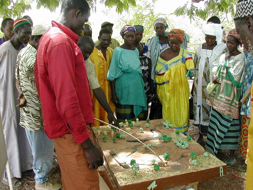
Scale models are an instructional tool that can be used to ensure a common understanding of the characteristics of the lowland area to be developed, give concrete expression to the baseline scenario, and facilitate discussion of the different technical options for the development. Depending on the case at hand, the model shows flooded areas, forested areas, housing, areas given over to pasture or cultivation and the type of scheme that has been chosen with the beneficiaries. Ultimately, a wooden 3D version of the model is produced that is around 80 x 120 centimetres in size. The model is a visual aid that improves communication between the different actors involved and the technical designers during the planning process and development of the lowland area (communities, design agencies and businesses tasked with implementation, etc.). The model is a tool that helps to foster the actors’ ownership of the process, the creation of a shared future vision of the development, and the collaborative management of schemes. It must, however, form part of an overall facilitation approach.
The model is one tool in the toolkit of lowland planning approaches. The process begins with the request by a community and/or local authority for a scheme. A brief for the development scheme is then drawn up jointly by those involved. The project itself starts with a socio-economic study carried out in accordance with the ToR submitted to the community. Approval for the choice of site is obtained in the course of the socio-economic study, which leads into a technical study based on the findings and the summary draft document (SDD). Study findings are fed back to villagers along with the selected scenario. A 3D wooden model is then produced on the basis of the findings and scenario. The other scheme implementation stages are carried out following approval (summary draft document – SDD, drafting of the tender documents – ITD, choice of contractor, works, approval of works completed). The model is subsequently used to move the farming and facility maintenance strategy forward. Two or three village facilitators, who are members of the management committee, are trained in how to handle the model during facilitation sessions.
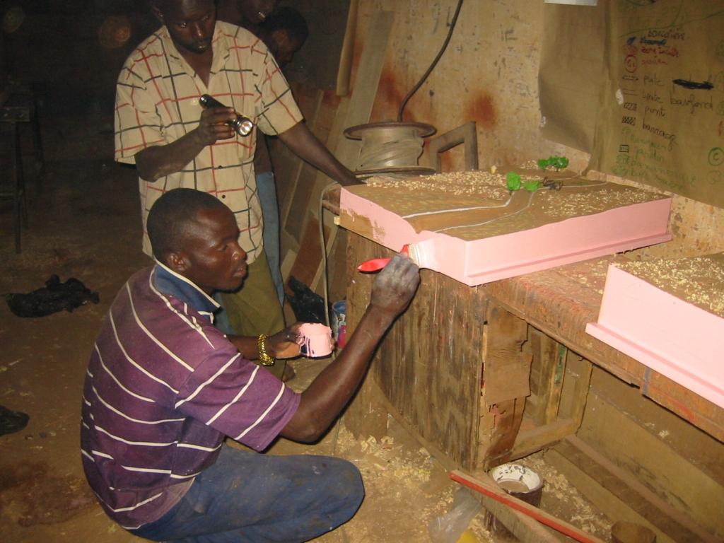
Stages in creating a model: 1)Sketch mapping (involving farmers) and a topographical survey of the area, 2)Precise order placed with the model maker (specification), 3)Provision of a quote by the model maker setting out the costs of the materials and services required (if necessary, a site visit is carried out with the model maker to work through the paper maps of the lowland area), 4)Conversion of the paper maps to the actual scale of the model, 5)Production of the base unit with the basic relief (boards, plywood), 6)Positioning of the technical features to be installed (facilities, roads, irrigated plots, ponds, etc.) and the addition of decorative elements (houses, trees, livestock), 7)Production of a protective shipping case for the model.
Beneficiaries formulate the request, describe and draw sketch maps of the landscape, and use the model in consultation exercises. The consultancy supports the design process, ensures the quality
of on-paper designs for use in constructing the model, and acts as intermediary between the beneficiaries and the woodworker, particularly in terms of converting scales and proportions. The woodworker creates the model according to the plan.
2.3 该方法的照片
媒体库
2.5 采用该方法的国家/地区/地点
国家:
马里
区域/州/省:
Mali
有关地点的进一步说明:
Sikasso, Koutiala, Kadiolo and Yorosso, San and Tominian
2.6 该方法的开始和终止日期
注明开始年份:
2005
2.7 方法的类型
- 基于项目/方案
2.8 该方法的主要目的/目标
The Approach focused mainly on SLM with other activities.
Encouraging the different actors to enter into negotiations and participate in decision-making on the design and farming of a lowland areas; reduction of conflicts over farming land
The SLM Approach addressed the following problems: lack of participation of the farming community in the development of lowland areas, conflicts over farming land
2.9 推动或妨碍实施本办法所适用的技术的条件
机构设置
- 阻碍
lack of participation of the farming community in the development of lowland areas
Treatment through the SLM Approach: Creating models when developing lowland areas encourages the different actors involved to enter into negotiations and participate in decision-making on the design and farming of a lowland area.
3. 相关利益相关者的参与和角色
3.1 该方法涉及的利益相关者及其职责
- 当地土地使用者/当地社区
- SLM专家/农业顾问
- NGO
HELVETAS
- 国家政府(规划者、决策者)
3.2 当地土地使用者/当地社区参与该方法的不同阶段
| 当地土地使用者/当地社区的参与 | 指定参与人员并描述活动 | |
|---|---|---|
| 启动/动机 | 被动 | |
| 计划 | 互动 | |
| 实施 | 互动 | |
| 监测/评估 | 被动 | |
| Research | 被动 |
3.4 有关SLM技术选择的决策
具体说明谁有权决定选择要实施的技术:
- 主要是SLM专家,咨询土地使用者之后
解释:
Decisions on the method of implementing the SLM Technology were made by mainly by SLM specialists with consultation of land users
4. 技术支持、能力建设和知识管理
4.1 能力建设/培训
是否为土地使用者/其他利益相关者提供培训?:
是
明确受训人员:
- 土地使用者
培训形式:
- 公开会议
- 课程
涵盖的主题:
Local people need to get to grips with the landscape and know how to orientate themselves in the space. The model maker must be well trained and have expertise in concepts of scale, contours and ‘scale exaggerations’
4.2 咨询服务
土地使用者有权使用咨询服务吗?:
是
指明是否提供了咨询服务:
- 在土地使用者的土地上
说明/注释:
Advisory service is quite adequate to ensure the continuation of land conservation activities; the model is facilitated by villagers themselves
4.3 机构强化(组织发展)
是否通过这种方法建立或加强了机构?:
- 是,适度
具体说明机构的强化或建立程度:
- 本地
具体说明支持类型:
- 能力建设/培训
- 设备
4.4 监测和评估
监测和评估是该方法的一部分吗?:
是
注释:
technical aspects were ad hoc monitored by project staff through observations
socio-cultural aspects were ad hoc monitored by project staff through observations
management of Approach aspects were ad hoc monitored by project staff through observations
There were no changes in the Approach as a result of monitoring and evaluation
There were no changes in the Technology as a result of monitoring and evaluation
4.5 研究
研究是该方法的一部分吗?
是
明确话题:
- 社会学
- 经济/市场营销
- 生态学
- 技术
提供进一步的细节,并指出是谁做的研究:
Helvetas - Swiss Intercooperation
5. 融资和外部物质支持
5.1 该方法中SLM组成部分的年度预算
如果不知道准确的年度预算,请给出一个范围:
- < 2,000
注释(例如主要的资助来源/主要捐助者):
Approach costs were met by the following donors: international non-government: 100.0%
5.2 为土地使用者提供财政/物质支援
土地使用者是否获得实施该技术的财政/物质支持?:
是
5.3 对特定投入的补贴(包括劳动力)
如果土地使用者的劳动力是一项重要的投入,那么是不是:
- 自愿
5.4 信用
是否根据SLM活动的方法给予信用值?:
否
6. 影响分析和结论性陈述
6.1 方法的影响
该方法是否帮助土地使用者实施和维护SLM技术?:
- 否
- 是,很少
- 是,中等
- 是,支持力度很大
reduced conflicts over farming land and immediate visibility of the land pattern and spatial issues
该方法是否有助于社会和经济弱势群体?:
- 否
- 是,很少
- 是,中等
- 是,支持力度很大
It is an approach that is more engaging and accessible to all – even the shyest people are able to express themselves.
Did other land users / projects adopt the Approach?
- 否
- 是,很少
- 是,中等
- 是,支持力度很大
This tool has been used in the regions of Sikasso (Sikasso, Koutiala, Kadiolo and Yorosso) and Ségou (San and Tominian) for all the schemes delivered by HELVETAS Swiss Intercooperation. In total, more than 25 models have been made.
Did the Approach lead to improved livelihoods / human well-being?
- 否
- 是,很少
- 是,中等
- 是,支持力度很大
The model is tangible, durable and helps reduce social conflict. Involvement and motivation of local people in the design process is ensured. The model enables stakeholders to interpret the landscape and thus helps them in the decision-making process. It is used in consultation exercises to ensure transparency and consensual management in the implementation and evaluation of the scheme.
Did the Approach help to alleviate poverty?
- 否
- 是,很少
- 是,中等
- 是,支持力度很大
6.2 土地使用者实施SLM的主要动机
- 增加生产
- 增加利润(能力),提高成本效益比
- 支付/补贴
- 环境意识
- well-being and livelihoods improvement
6.3 方法活动的可持续性
土地使用者能否维持通过该方法实施的措施(无外部支持的情况下)?:
- 是
6.4 该方法的长处/优点
| 编制者或其他关键资源人员认为的长处/优势/机会 |
|---|
| The results are immediate and manifest as: reduced conflicts over farming the land in question; the immediate visibility of the land pattern and spatial issues; the involvement and motivation of local people in the design process; more inclusive decisions and the initiation of social dialogue on the scheme; an approach that is more engaging and accessible to all – even the shyest people are able to express themselves. (How to sustain/ enhance this strength: The approach must be participatory; it should not exclude any sector of society. In this respect, young people and women prove to be very good facilitators, with the model helping them to present the subject matter in a lively and engaging way.) |
|
The model enables stakeholders to interpret the landscape and thus helps them in the decision-making process. It is used in consultation exercises to ensure transparency and consensual management in the implementation and evaluation of the scheme. (How to sustain/ enhance this strength: To use the model, all that is required is for it to be transported to the meeting/facilitation space, removed from its case and placed at table height or even on the ground. The facilitator then introduces the project, indicating the landmarks and cardinal directions. This serves as the basis for discussion. Local people need to get to grips with the landscape and know how to orientate themselves in the space. The model maker must be well trained and have expertise in concepts of scale, contours and ‘scale exaggerations’. They must have an artist’s eye. ) |
| The model is tangible, durable and helps reduce social conflict. It also serves as a support for meetings with visitors. It is facilitated by villagers themselves. |
6.5 该方法的弱点/缺点以及克服它们的方法
| 编制者或其他关键资源人员认为的弱点/缺点/风险 | 如何克服它们? |
|---|---|
| Some experts from technical consultancies have the tendency to take over from the beneficiaries. Other public sector experts move things forward as quickly as possible and fail to take into account villagers’ contributions. |
To ensure that people are not left frustrated and, as a result, participate less in the process, it is important to give them the opportunity to express their views. |
| Modifications may be required once the model is completed. Integrating these corrections can prove difficult (engaging the same provider and carrying out alterations without diminishing the appearance of the model). |
7. 参考和链接
7.1 方法/信息来源
- 实地考察、实地调查
- 与土地使用者的访谈
7.2 参考可用出版物
标题、作者、年份、ISBN:
Intercooperation, Délégation au Sahel (n.d.): Capitalisation d’éxperience. Eau, terre, communautés. La maquette pédagogique transportable dans l’aménagement des bas-fonds. Un outil pour les practiciens. [Delegation to the Sahel (n.d.): Capitalising on experiences. Water, land, communities. The portable instructional model for developing lowland schemes. A tool for practitioners.]
可以从哪里获得?成本如何?
http://agriwaterpedia.info/wiki/Main_Page
标题、作者、年份、ISBN:
Intercooperation, Délégation au Sahel (2009): Gestion des ressources naturelles: les acteurs s’engagent pour une gestion concertée et pacifique de leurs resources. [Delegation to the Sahel (2009): Management of natural resources – actors engage in the collaborative and peaceful management of their resources.]
标题、作者、年份、ISBN:
Good Practices in Soil and Water Conservation. A contribution to adaptation and farmers´ resilience towards climate change in the Sahel. Published by GIZ in 2012.
可以从哪里获得?成本如何?
http://agrwaterpedia.info/wiki/Main_Page
链接和模块
全部展开 全部收起链接
无链接
模块
无模块