Willows and gabions will protect the village from Riverbank erosion (Nodir Muhidinov)

Prevention of riverbank erosion by combination of green and grey measures (ทาจิกิสถาน)

Защита берега реки путем комбинации строений и посадок

คำอธิบาย

Flashfloods in riverbeds cause intensive riverbank erosion, which threatens villages, infrastructure and productive lands. Preventive measures combining "grey" (physical structures) and "green" (living trees) elements are more effective, sustainable and cost efficient than constructive measures only.

Villages at the northern slopes of the Turkestan range in Sughd region are often located at riverbanks. The amounts of water flowing in the river channels naturally varies much during the year. After intensive rainfall or snowmelt the water flow can suddenly increase manifold. These flashfloods carry huge amounts of debris and are therefore even more destructive. The combined effects of degradation of woodlands and rangelands in the upper catchments and the impact of climate change with accelerated snowmelt and higher frequency and intensity of heavy rainfall events have increased the risks of these debris flows. In several villages of Sughd region, especially in Spitamen and Devashtich districts, riverbank erosion during flashflood and debris flows increasingly threatened houses, infrastructure and productive lands.

GIZ in collaboration with the local branches of the Committee for Emergency Situations, district and sub-district authorities assisted local community in the implementation of riverbank protection measures. The design of the protective structure was specifically adapted to the local situation. For achieving immediately reliable protection structural measures (“grey”) included:
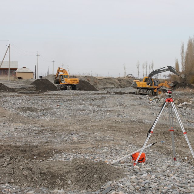
•Modification of river channels with excavators and bulldozers to redirect flows;
•Erection of dykes and spurs from large rocks along erosion prone riverbanks;
•Erection of lateral gabion walls along erosion prone riverbanks;
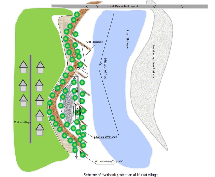
•Erection of gabion spurs, which concentrate the water flow in the center of the river channel and thus reduce the force of water and debris on riverbanks and lateral gabion walls.

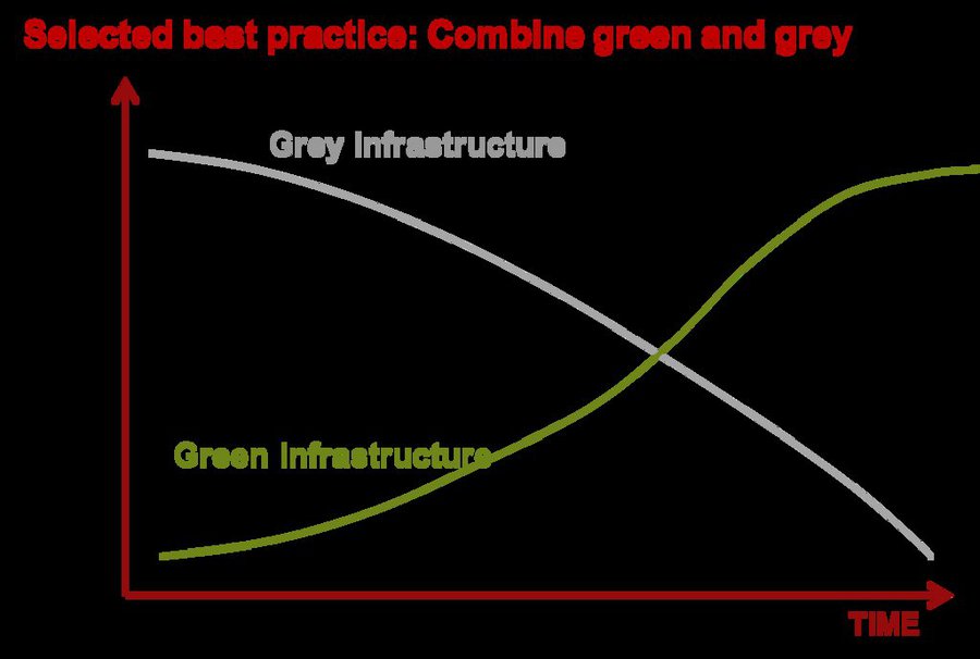
In the long run “grey” measures tend to be damaged by flashfloods and debris flows. “Green” measures can enforce the protective structures and thus increase the sustainability, effectiveness and cost efficiency of structural measures. Willows are particularly suitable for erosion prevention in river channels as they grow fast, establish a large fixing root system in the riverbed, their wood is flexible and withstands intensive force and they well regenerate after damage. “Green” measures for reinforcing riverbank protection included:
•Planting of single willow saplings in rows immediately behind stone dykes;
•Planting of willows in form of one or several rows of three seedlings per spot, connected with cords to “tripods” to increase stability;
•Planting of willows in form of one or several rows of three seedlings per spot, connected with cords to “tripods” around a small gabion, which additionally increases the resistance of the planted willows against the forces of water and debris.

The works have been overseen by the GIZ engineer, GIZ also covered expenses for gabion nets and machinery, while willow branches and labor were provided by the communities.

After up to five years the riverbank protection is still functional at all sites and prevented damage from floods to lives and property. No substantial damage occurred to the erected structures despite several heavy flashflood and debris flow events at all sites. Most planted willows established well, have substantially grown and provide an increasingly effective protection. In few spots willows dried up, where washed out or damaged by livestock and replanting would be necessary to maintain the effectiveness of the riverbank protection. In the future the willows can be used as coppice wood with their large branches cut, providing new planting material for additional “green” protection measures, for construction and as fuel. Additionally the willows contribute to the local biodiversity by providing habitat for birds and other animals, improve the microclimate and improve the view of the villages and the landscape. The multiple benefits from the “green” measures are expected to motivate care by the villagers, in particular prevention of damage caused by livestock and insufficient water supply and replanting of lost trees.
สถานที่

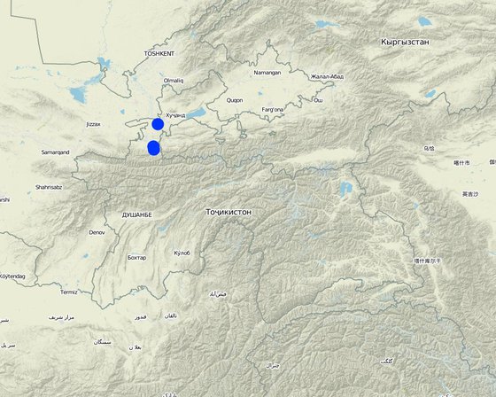
สถานที่: Spitamen district, Devashtich district, Sughd region, ทาจิกิสถาน

ตำนวนการวิเคราะห์เทคโนโลยี: 2-10 แห่ง

ตำแหน่งทางภูมิศาสตร์ของสถานที่ที่ถูกเลือ
  • 69.24369, 40.12907
  • 69.14683, 39.75155
  • 69.16151, 39.7027

การเผยแพร่ของเทคโนโลยี: ใช้ ณ จุดที่เฉพาะเจาะจงหรือเน้นไปยังบริเวณพื้นที่ขนาดเล็ก

In a permanently protected area?: ไม่ใช่

วันที่ในการดำเนินการ: 2013; น้อยกว่า 10 ปี (ไม่นานนี้)

ประเภทของการแนะนำ
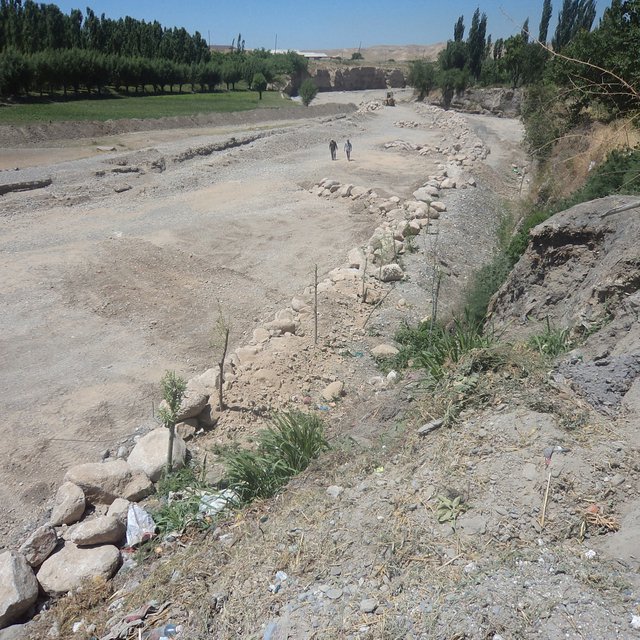
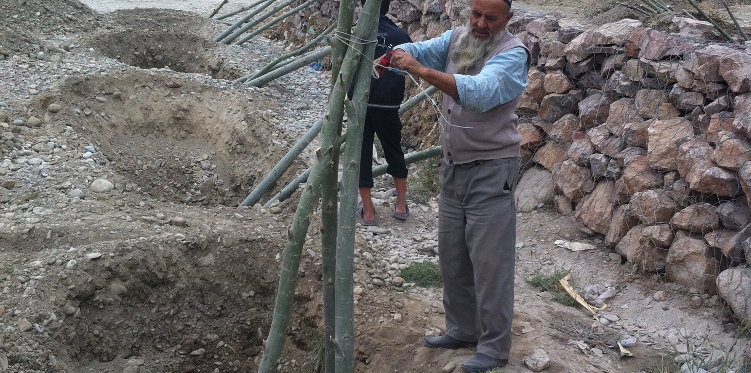
Stone dyke with row of willow trees (Nodir Muhidinov)
Reshaping the riverbed (Nodir Muhidinov)

การจำแนกประเภทเทคโนโลยี

จุดประสงค์หลัก
  • ปรับปรุงการผลิตให้ดีขึ้น
  • ลด ป้องกัน ฟื้นฟู การเสื่อมโทรมของที่ดิน
  • อนุรักษ์ระบบนิเวศน์
  • ป้องกันพื้นที่ลุ่มน้ำ/บริเวณท้ายน้ำ โดยร่วมกับเทคโนโลยีอื่นๆ
  • รักษาสภาพหรือปรับปรุงความหลากหลายทางชีวภาพ
  • ลดความเสี่ยงของภัยพิบัติ
  • ปรับตัวเข้ากับการเปลี่ยนแปลงภูมิอากาศของโลก สภาพภูมิอากาศที่รุนแรงและผลกระทบ
  • ชะลอการเปลี่ยนแปลงภูมิอากาศของโลกและผลกระทบ
  • สร้างผลกระทบทางด้านเศรษฐกิจที่เป็นประโยชน์
  • สร้างผลกระทบทางด้านสังคมที่เป็นประโยชน์
การใช้ที่ดิน

  • ป่า/พื้นที่ทำไม้ Tree types (deciduous): n.a.
    ผลิตภัณฑ์และบริการ: ไม้ที่นำมาทำเป็นเชื้อเพลิง, การแทะเล็มหญ้า / การเก็บกินหญ้า, การอนุรักษ์ / ป้องกันธรรมชาติ, นันทนาการ / การท่องเที่ยว, การป้องกันภัยธรรมชาติ
  • การตั้งถิ่นฐาน โครงสร้างพื้นฐาน - การตั้งถิ่นฐาน ตึกอาคาร, การจราจร ทางถนน รถไฟ
  • ทางน้ำ แหล่งน้ำ พื้นที่ชุ่มน้ำ - ทางระบายน้ำ ทางน้ำ
การใช้น้ำ
  • จากน้ำฝน
  • น้ำฝนร่วมกับการชลประทาน
  • การชลประทานแบบเต็มรูปแบบ

ความมุ่งหมายที่เกี่ยวข้องกับการเสื่อมโทรมของที่ดิน
  • ป้องกันความเสื่อมโทรมของที่ดิน
  • ลดความเสื่อมโทรมของดิน
  • ฟื้นฟูบำบัดที่ดินที่เสื่อมโทรมลงอย่างมาก
  • ปรับตัวกับสภาพความเสื่อมโทรมของที่ดิน
  • ไม่สามารถใช้ได้
ที่อยู่ของการเสื่อมโทรม
  • การกัดกร่อนของดินโดยน้ำ - Wr (Riverbank erosion): การกัดกร่อนริมฝั่งแม่น้ำ
กลุ่ม SLM
  • การลดความเสี่ยงจากภัยพิบัติบนพื้นฐานของระบบนิเวศ
มาตรการ SLM
  • มาตรการอนุรักษ์ด้วยวิธีพืช - V1: ต้นไม้และพุ่มไม้คลุมดิน
  • มาตรการอนุรักษ์ด้วยโครงสร้าง - S5: เขื่อน ชั้นดินที่แน่นแข็งบ่อน้ำ, S11: อื่น ๆ

แบบแปลนทางเทคนิค

ข้อมูลจำเพาะด้านเทคนิค
Scheme how over time "green" and "grey" measures are functional.
Author: Nodir Muhidinov
None
Author: Nodir Muhidinov, modified by Stefan Michel

การจัดตั้งและการบำรุงรักษา: กิจกรรม ปัจจัยและค่าใช้จ่าย

การคำนวนต้นทุนและค่าใช้จ่าย
  • ค่าใช้จ่ายถูกคำนวน
  • สกุลเงินที่ใช้คำนวณค่าใช้จ่าย TJS
  • อัตราแลกเปลี่ยน (ไปเป็นดอลลาร์สหรัฐ) คือ 1 ดอลลาร์สหรัฐ = 6.0 TJS
  • ค่าจ้างเฉลี่ยในการจ้างแรงงานต่อวันคือ ไม่มีคำตอบ
ปัจจัยที่สำคัญที่สุดที่มีผลต่อค่าใช้จ่าย
n.a.
กิจกรรมเพื่อการจัดตั้ง
  1. Modification of river channel (ช่วงระยะเวลา/ความถี่: Fall)
  2. Erection of stone dykes and spurs (ช่วงระยะเวลา/ความถี่: Fall)
  3. Building of gabions (ช่วงระยะเวลา/ความถี่: Fall)
  4. Planting of willow trees, "tripods" (ช่วงระยะเวลา/ความถี่: Fall)
ปัจจัยและค่าใช้จ่ายของการจัดตั้ง
ปัจจัยนำเข้า หน่วย ปริมาณ ค่าใช้จ่ายต่อหน่วย (TJS) ค่าใช้จ่ายทั้งหมดต่อปัจจัยนำเข้า (TJS) %ของค่าใช้จ่ายที่ก่อให้เกิดขึ้นโดยผู้ใช้ที่ดิน
แรงงาน
Construction of tripod from a willow tree and gabion net pieces 46.0
Constrcution of gabion spurs 381.0
Laying down gabion net 812.4
อุปกรณ์
Excavator 1800.0
Buldozer 7040.0
วัสดุด้านพืช
willow tree tripods pieces 46.0
วัสดุสำหรับก่อสร้าง
Gabion net 812.4
Stones for gabions 381.0
กิจกรรมสำหรับการบำรุงรักษา
  1. Prevention of damage to trees from livestock (ช่วงระยะเวลา/ความถี่: Year round)
  2. Improvised irrigation (ช่วงระยะเวลา/ความถี่: During seasons of low water availability at the planting sites)
  3. Closing of washed out places (ช่วงระยะเวลา/ความถี่: After damage detected)
  4. Replanting (ช่วงระยะเวลา/ความถี่: Fall)

สิ่งแวดล้อมทางธรรมชาติ

ปริมาณน้ำฝนเฉลี่ยรายปี
  • < 250 ม.ม.
  • 251-500 ม.ม.
  • 501-750 ม.ม.
  • 751-1,000 ม.ม.
  • 1,001-1,500 ม.ม.
  • 1,501-2,000 ม.ม.
  • 2,001-3,000 ม.ม.
  • 3,001-4,000 ม.ม.
  • > 4,000 ม.ม.
เขตภูมิอากาศเกษตร
  • ชื้น
  • กึ่งชุ่มชื้น
  • กึ่งแห้งแล้ง
  • แห้งแล้ง
ข้อมูลจำเพาะเรื่องภูมิอากาศ
Rainfall varies between the areas but of relevance is rainfall in the upper catchments, where no reference meteorolgical station exists.
The climate varies between the areas but of relevance is the climate and weather in the upper catchments.
ความชัน
  • ราบเรียบ (0-2%)
  • ลาดที่ไม่ชัน (3-5%)
  • ปานกลาง (6-10%)
  • เป็นลูกคลื่น (11-15%)
  • เป็นเนิน (16-30%)
  • ชัน (31-60%)
  • ชันมาก (>60%)
ภูมิลักษณ์
  • ที่ราบสูง/ที่ราบ
  • สันเขา
  • ไหล่เขา
  • ไหล่เนินเขา
  • ตีนเนิน
  • หุบเขา
ความสูง
  • 0-100 เมตร
  • 101-500 เมตร
  • 501-1,000 เมตร
  • 1,001-1,500 เมตร
  • 1,501-2,000 เมตร
  • 2,001-2,500 เมตร
  • 2,501-3,000 เมตร
  • 3,001-4,000 เมตร
  • > 4,000 เมตร
เทคโนโลยีถูกประยุกต์ใช้ใน
  • บริเวณสันเขา (convex situations)
  • บริเวณแอ่งบนที่ราบ (concave situations)
  • ไม่เกี่ยวข้อง
ความลึกของดิน
  • ตื้นมาก (0-20 ซ.ม.)
  • ตื้น (21-50 ซ.ม.)
  • ลึกปานกลาง (51-80 ซ.ม.)
  • ลึก (81-120 ซ.ม.)
  • ลึกมาก (>120 ซ.ม.)
เนื้อดิน (ดินชั้นบน)
  • หยาบ/เบา (ดินทราย)
  • ปานกลาง (ดินร่วน ทรายแป้ง)
  • ละเอียด/หนัก (ดินเหนียว)
เนื้อดิน (> 20 ซม. ต่ำกว่าพื้นผิว)
  • หยาบ/เบา (ดินทราย)
  • ปานกลาง (ดินร่วน ทรายแป้ง)
  • ละเอียด/หนัก (ดินเหนียว)
สารอินทรียวัตถุในดิน
  • สูง (>3%)
  • ปานกลาง (1-3%)
  • ต่ำ (<1%)
น้ำบาดาล
  • ที่ผิวดิน
  • <5 เมตร
  • 5-50 เมตร
  • > 50 เมตร
ระดับน้ำบาดาลที่ผิวดิน
  • เกินพอ
  • ดี
  • ปานกลาง
  • ไม่ดีหรือไม่มีเลย
คุณภาพน้ำ (ยังไม่ได้รับการบำบัด)
  • เป็นน้ำเพื่อการดื่มที่ดี
  • เป็นน้ำเพื่อการดื่มที่ไม่ดี (จำเป็นต้องได้รับการบำบัด)
  • เป็นน้ำใช้เพื่อการเกษตรเท่านั้น (การชลประทาน)
  • ใช้ประโยชน์ไม่ได้
Water quality refers to:
ความเค็มของน้ำเป็นปัญหาหรือไม่?
  • ใช่
  • ไม่ใช่

การเกิดน้ำท่วม
  • ใช่
  • ไม่ใช่
ความหลากหลายทางชนิดพันธุ์
  • สูง
  • ปานกลาง
  • ต่ำ
ความหลากหลายของแหล่งที่อยู่
  • สูง
  • ปานกลาง
  • ต่ำ

ลักษณะเฉพาะของผู้ใช้ที่ดินที่ประยุกต์ใช้เทคโนโลยี

เป้าหมายทางการตลาด
  • เพื่อการยังชีพ (หาเลี้ยงตนเอง)
  • mixed (subsistence/ commercial)
  • ทำการค้า/การตลาด
รายได้จากภายนอกฟาร์ม
  • < 10% ของรายได้ทั้งหมด
  • 10-50% ของรายได้ทั้งหมด
  • > 50% ของรายได้ทั้งหมด
ระดับของความมั่งคั่งโดยเปรียบเทียบ
  • ยากจนมาก
  • จน
  • พอมีพอกิน
  • รวย
  • รวยมาก
ระดับของการใช้เครื่องจักรกล
  • งานที่ใช้แรงกาย
  • การใช้กำลังจากสัตว์
  • การใช้เครื่องจักรหรือเครื่องยนต์
อยู่กับที่หรือเร่ร่อน
  • อยู่กับที่
  • กึ่งเร่ร่อน
  • เร่ร่อน
เป็นรายบุคคลหรือกลุ่ม
  • เป็นรายบุคคล/ครัวเรือน
  • กลุ่ม/ชุมชน
  • สหกรณ์
  • ลูกจ้าง (บริษัท รัฐบาล)
เพศ
  • หญิง
  • ชาย
อายุ
  • เด็ก
  • ผู้เยาว์
  • วัยกลางคน
  • ผู้สูงอายุ
พื้นที่ที่ใช้ต่อครัวเรือน
  • < 0.5 เฮกตาร์
  • 0.5-1 เฮกตาร์
  • 1-2 เฮกตาร์
  • 2-5 เฮกตาร์
  • 5-15 เฮกตาร์
  • 15-50 เฮกตาร์
  • 50-100 เฮกตาร์
  • 100-500 เฮกตาร์
  • 500-1,000 เฮกตาร์
  • 1,000-10,000 เฮกตาร์
  • >10,000 เฮกตาร์
ขนาด
  • ขนาดเล็ก
  • ขนาดกลาง
  • ขนาดใหญ่
กรรมสิทธิ์ในที่ดิน
  • รัฐ
  • บริษัท
  • เป็นแบบชุมชนหรือหมู่บ้าน
  • กลุ่ม
  • รายบุคคล ไม่ได้รับสิทธิครอบครอง
  • รายบุคคล ได้รับสิทธิครอบครอง
สิทธิในการใช้ที่ดิน
  • เข้าถึงได้แบบเปิด (ไม่ได้จัดระเบียบ)
  • เกี่ยวกับชุมชน (ถูกจัดระเบียบ)
  • เช่า
  • รายบุคคล
สิทธิในการใช้น้ำ
  • เข้าถึงได้แบบเปิด (ไม่ได้จัดระเบียบ)
  • เกี่ยวกับชุมชน (ถูกจัดระเบียบ)
  • เช่า
  • รายบุคคล
เข้าถึงการบริการและโครงสร้างพื้นฐาน
สุขภาพ

จน
x
ดี
การศึกษา

จน
x
ดี
ความช่วยเหลือทางด้านเทคนิค

จน
x
ดี
การจ้างงาน (เช่น ภายนอกฟาร์ม)

จน
x
ดี
ตลาด

จน
x
ดี
พลังงาน

จน
x
ดี
ถนนและการขนส่ง

จน
x
ดี
น้ำดื่มและการสุขาภิบาล

จน
x
ดี
บริการด้านการเงิน

จน
x
ดี

ผลกระทบ

ผลกระทบทางด้านเศรษฐกิจและสังคม
การผลิตพืชผล
ลดลง
x
เพิ่มขึ้น


Locally additional land reclaimed for fruit trees.

การผลิตไม้
ลดลง
x
เพิ่มขึ้น

จำนวนก่อน SLM: 0
หลังจาก SLM: Some
Use of willow branches for small construction and as fuel

Damage from disasters
Increased
x
Decreased

จำนวนก่อน SLM: High damage
หลังจาก SLM: Low or zero damage

ผลกระทบด้านสังคมและวัฒนธรรม
ผลกระทบด้านนิเวศวิทยา
ดินถล่ม/ ซากต่าง ๆ ที่ถูกพัดพามา
เพิ่มขึ้น
x
ลดลง


Effective protection against medium and large events, potentially no full protection in case of extreme events.

Greening, biodiversity
Reduced
x
Improved


Local improvement due to trees planted

ผลกระทบนอกพื้นที่ดำเนินการ
ความเสียหายต่อพื้นที่เพาะปลูกของเพื่อนบ้าน
เพิ่มขึ้น
x
ลดลง


Redirected river channel can locally cause lateral erosion.

รายได้และค่าใช้จ่าย

ผลประโยชน์ที่ได้รับเปรียบเทียบกับค่าใช้จ่าย
ผลตอบแทนระยะสั้น
ด้านลบอย่างมาก
x
ด้านบวกอย่างมาก

ผลตอบแทนระยะยาว
ด้านลบอย่างมาก
x
ด้านบวกอย่างมาก

ผลประโยชน์ที่ได้รับเปรียบเทียบกับค่าใช้จ่ายในการบำรุงรักษา
ผลตอบแทนระยะสั้น
ด้านลบอย่างมาก
x
ด้านบวกอย่างมาก

ผลตอบแทนระยะยาว
ด้านลบอย่างมาก
x
ด้านบวกอย่างมาก

การเปลี่ยนแปลงของสภาพภูมิอากาศ

สภาพรุนแรงของภูมิอากาศ (ภัยพิบัติ)
น้ำท่วมฉับพลัน

ไม่ดี
x
ดีมาก

การน้อมเอาความรู้และการปรับใช้

เปอร์เซ็นต์ของผู้ใช้ที่ดินในพื้นที่ที่นำเทคโนโลยีไปใช้
  • ครั้งเดียวหรือเป็นการทดลอง
  • 1-10%
  • 11-50%
  • > 50%
จากทั้งหมดที่ได้รับเทคโนโลยีเข้ามามีจำนวนเท่าใดที่ทำแบบทันที โดยไม่ได้รับการจูงใจด้านวัสดุหรือการเงินใดๆ?
  • 0-10%
  • 11-50%
  • 51-90%
  • 91-100%
เทคโนโลยีได้รับการปรับเปลี่ยนเร็วๆ นี้เพื่อให้ปรับตัวเข้ากับสภาพที่กำลังเปลี่ยนแปลงหรือไม่?
  • ใช่
  • ไม่ใช่
สภาพที่กำลังเปลี่ยนแปลงอันไหน?
  • การเปลี่ยนแปลงแบบค่อยเป็นค่อยไปและสภาพรุนแรงของภูมิอากาศ
  • การเปลี่ยนแปลงของตลาด
  • การมีแรงงานไว้ให้ใช้ (เนื่องจากการอพยพย้ายถิ่นฐาน)
Instead of planting single trees "tripods" are planted. The "tripods" are stabilized by small gabions.

บทสรุปหรือบทเรียนที่ได้รับ

จุดแข็ง: มุมมองของผู้ใช้ที่ดิน
  • Long term sustainability.
  • Low costs.
  • Low maintenance needs.
  • Additional benefits (greening, wood).
จุดแข็ง: ทัศนคติของผู้รวบรวมหรือวิทยากรคนอื่นๆ
  • Same as land-users' view.
  • Increases lifetime of structural measures. As gabions lose stability due to aging of the gabion nets, the tree "tripods" gain stabilizing features.
จุดด้อย/ข้อเสีย/ความเสี่ยง: มุมมองของผู้ใช้ที่ดินแก้ไขปัญหาได้อย่างไร
  • None
จุดด้อย/ข้อเสีย/ความเสี่ยง: ทัศนคติของผู้รวบรวมหรือวิทยากรคนอื่นๆแก้ไขปัญหาได้อย่างไร
  • Trees can be damaged by livestock Community members need to be motivated to prevent damage and to replace dry trees.
  • During the first years trees can dry up if not enough water is available Community members need to be improvise irrigation when necessary and possible and should replace dry trees.

การอ้างอิง

ผู้รวบรวม
  • Stefan Michel
Editors
ผู้ตรวจสอบ
  • Umed Vahobov
วันที่จัดทำเอกสาร: 11 มกราคม 2019
การอัพเดทล่าสุด: 31 มกราคม 2019
วิทยากร
คำอธิบายฉบับเต็มในฐานข้อมูล WOCAT
ข้อมูล SLM ที่ถูกอ้างอิง
การจัดทำเอกสารถูกทำโดย
องค์กร โครงการ
This work is licensed under Creative Commons Attribution-NonCommercial-ShareaAlike 4.0 International