Prevention of riverbank erosion by combination of green and grey measures [ทาจิกิสถาน]
- ผู้สร้างสรรค์:
- การอัพเดท:
- ผู้รวบรวม: Stefan Michel
- ผู้เรียบเรียง: –
- ผู้ตรวจสอบ: Umed Vahobov
Защита берега реки путем комбинации строений и посадок
technologies_4311 - ทาจิกิสถาน
ดูส่วนย่อย
ขยายทั้งหมด ย่อทั้งหมด1. ข้อมูลทั่วไป
1.2 รายละเอียดที่ติดต่อได้ของผู้รวบรวมและองค์กรที่เกี่ยวข้องในการประเมินและการจัดเตรียมทำเอกสารของเทคโนโลยี
วิทยากรหลัก
ผู้เชี่ยวชาญ SLM:
Nodir Muhidinov
Deutsche Gesellschaft für Internationale Zusammenarbeit (GIZ)
ทาจิกิสถาน
ชื่อของโครงการซึ่งอำนวยความสะดวกในการทำเอกสารหรือการประเมินเทคโนโลยี (ถ้าเกี่ยวข้อง)
Strengthening of Livelihoods through Climate Change Adaptation in Kyrgyzstan and Tajikistanชื่อขององค์กรซึ่งอำนวยความสะดวกในการทำเอกสารหรือการประเมินเทคโนโลยี (ถ้าเกี่ยวข้อง)
Deutsche Gesellschaft für Internationale Zusammenarbeit - Tajikistan (GIZ Tajikistan) - ทาจิกิสถาน1.3 เงื่อนไขการใช้ข้อมูลที่ได้บันทึกผ่านทาง WOCAT
ผู้รวบรวมและวิทยากรหลักยอมรับเงื่อนไขเกี่ยวกับการใช้ข้อมูลที่ถูกบันทึกผ่านทาง WOCAT:
ใช่
1.4 การเปิดเผยเรื่องความยั่งยืนของเทคโนโลยีที่ได้อธิบายไว้
เทคโนโลยีที่ได้อธิบายไว้นี้เป็นปัญหาของความเสื่อมโทรมโทรมของที่ดินหรือไม่ จึงไม่ได้รับการยอมรับว่าเป็นเทคโนโลยีเพื่อการจัดการที่ดินอย่างยั่งยืน:
ไม่ใช่
1.5 Reference to Questionnaire(s) on SLM Approaches (documented using WOCAT)
Integrated disaster risk reduction in flood-affected areas by … [ทาจิกิสถาน]
Climate change and land degradation in upper catchment areas cause an increasing frequency and intensity of flash flood and debris flows affecting settlements and productive areas. GIZ in collaboration with the Committee on Emergency Situations assisted local communities in the implementation of integrated preventive measures.
- ผู้รวบรวม: Stefan Michel
2. การอธิบายลักษณะของเทคโนโลยี SLM
2.1 การอธิบายแบบสั้น ๆ ของเทคโนโลยี
คำจำกัดความของเทคโนโลยี:
Flashfloods in riverbeds cause intensive riverbank erosion, which threatens villages, infrastructure and productive lands. Preventive measures combining "grey" (physical structures) and "green" (living trees) elements are more effective, sustainable and cost efficient than constructive measures only.
2.2 การอธิบายแบบละเอียดของเทคโนโลยี
คำอธิบาย:
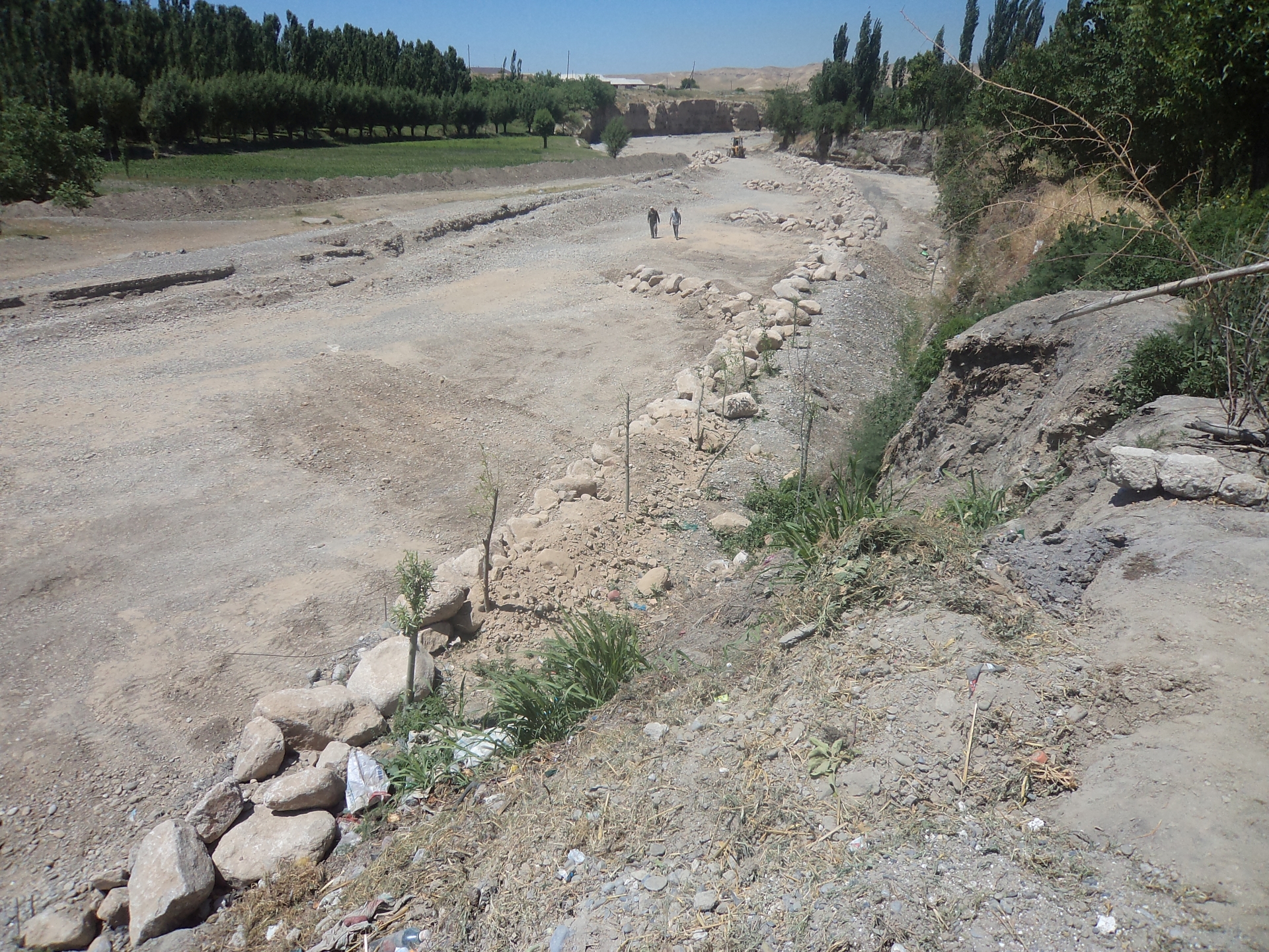
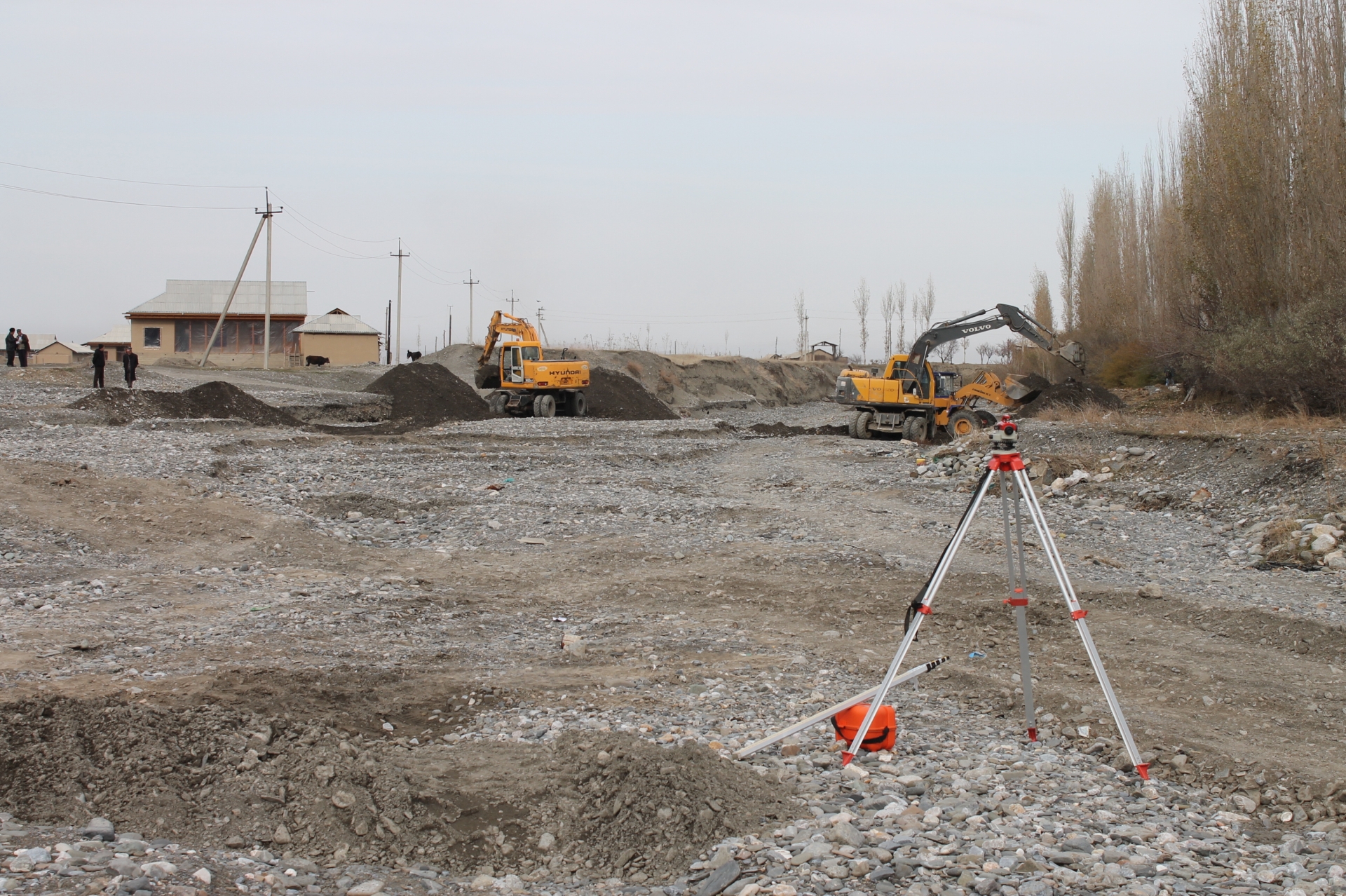
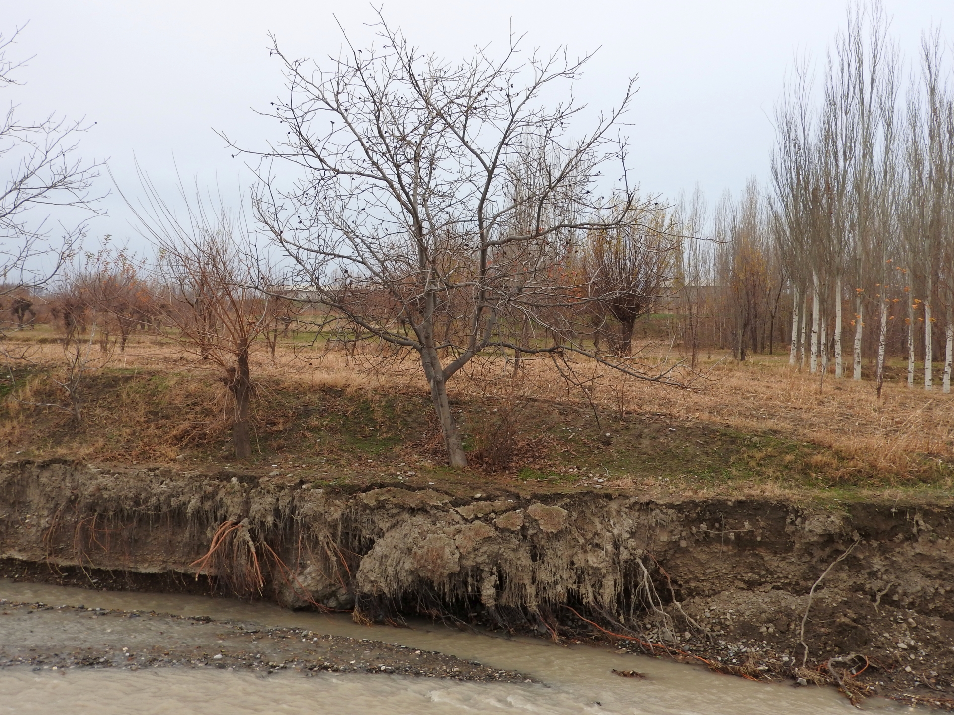
Villages at the northern slopes of the Turkestan range in Sughd region are often located at riverbanks. The amounts of water flowing in the river channels naturally varies much during the year. After intensive rainfall or snowmelt the water flow can suddenly increase manifold. These flashfloods carry huge amounts of debris and are therefore even more destructive. The combined effects of degradation of woodlands and rangelands in the upper catchments and the impact of climate change with accelerated snowmelt and higher frequency and intensity of heavy rainfall events have increased the risks of these debris flows. In several villages of Sughd region, especially in Spitamen and Devashtich districts, riverbank erosion during flashflood and debris flows increasingly threatened houses, infrastructure and productive lands.
GIZ in collaboration with the local branches of the Committee for Emergency Situations, district and sub-district authorities assisted local community in the implementation of riverbank protection measures. The design of the protective structure was specifically adapted to the local situation. For achieving immediately reliable protection structural measures (“grey”) included:
•Modification of river channels with excavators and bulldozers to redirect flows;
•Erection of dykes and spurs from large rocks along erosion prone riverbanks;
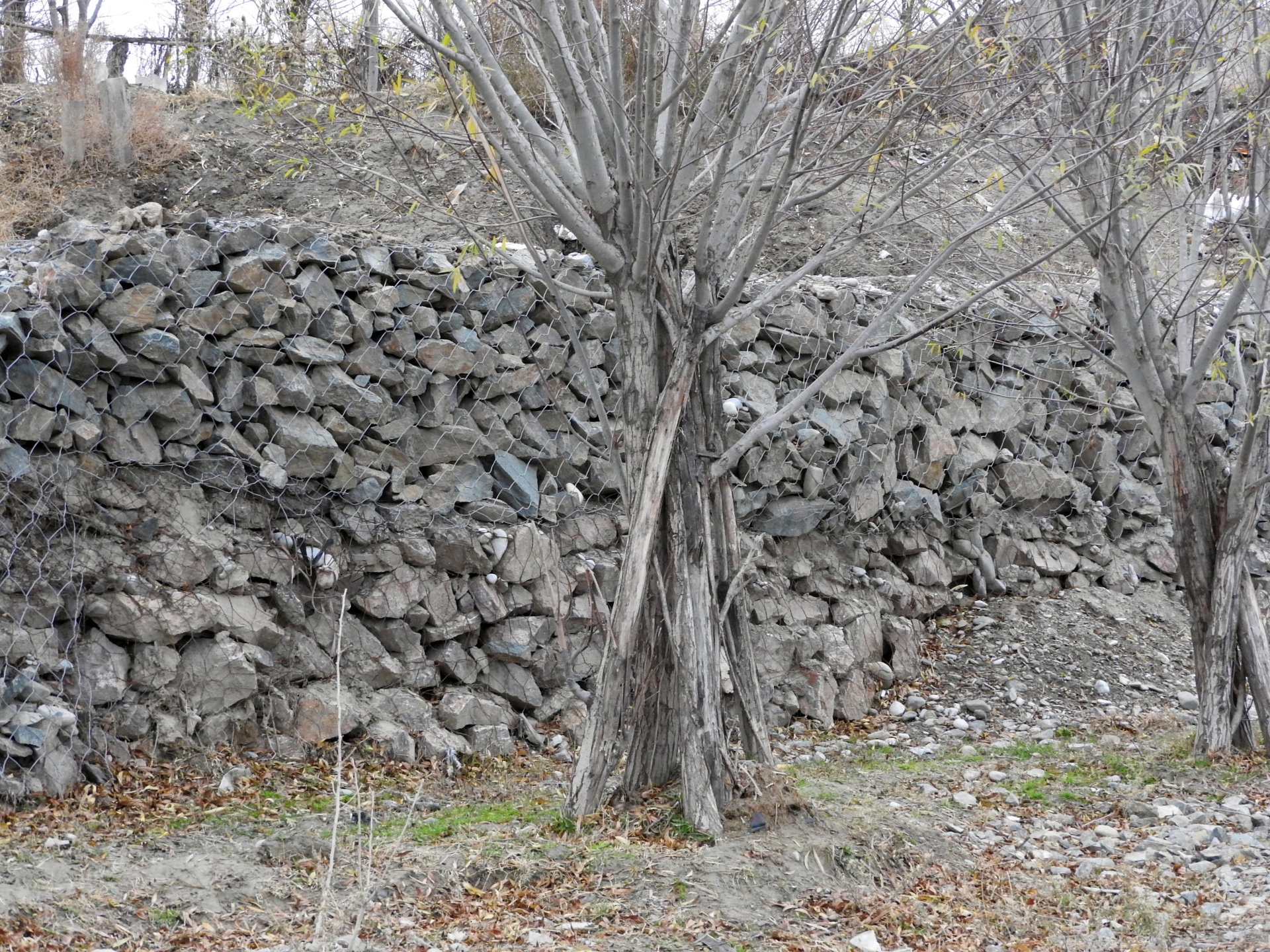
•Erection of lateral gabion walls along erosion prone riverbanks;
•Erection of gabion spurs, which concentrate the water flow in the center of the river channel and thus reduce the force of water and debris on riverbanks and lateral gabion walls.
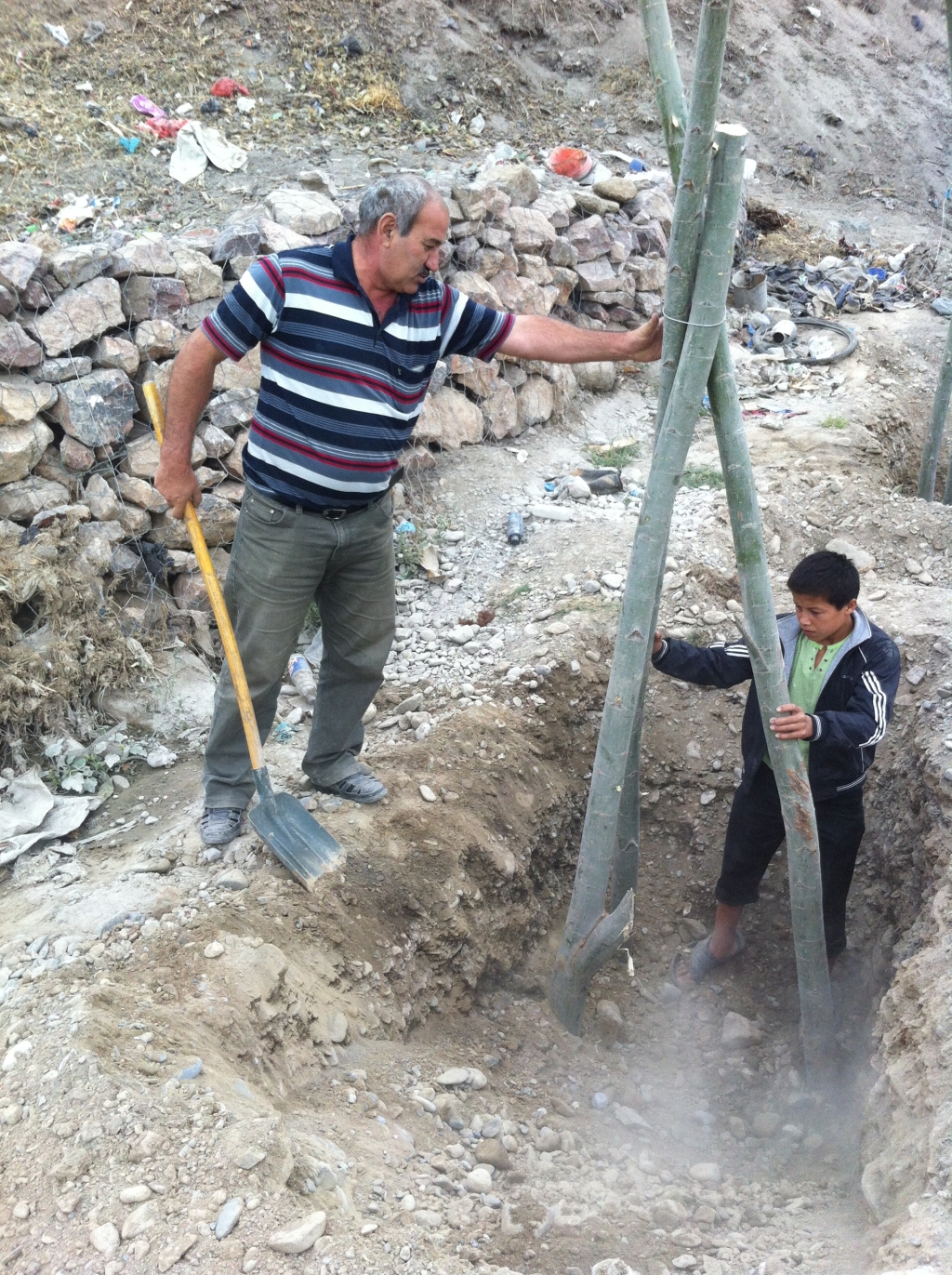
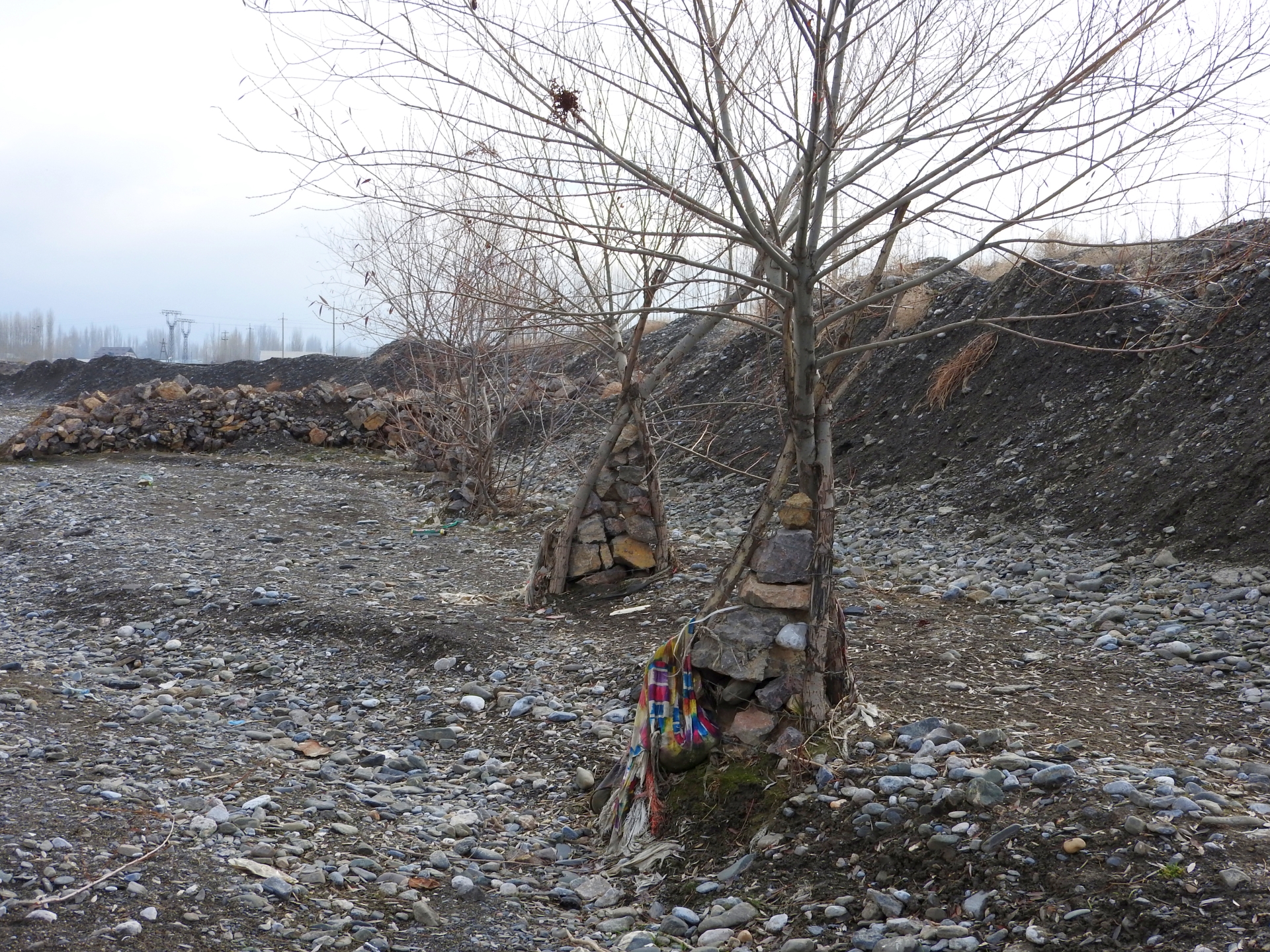
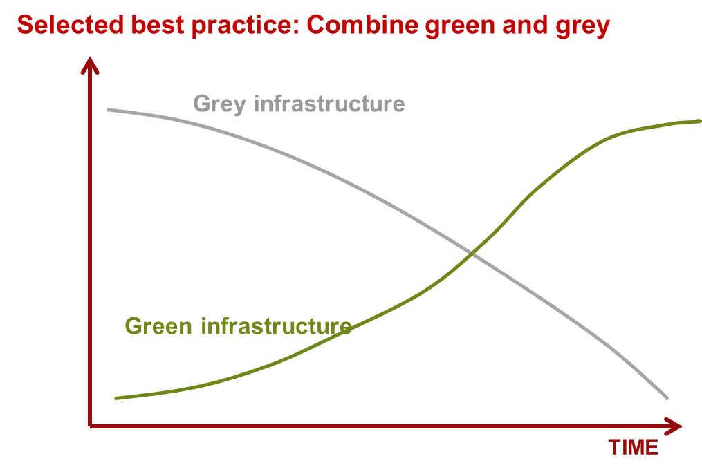
In the long run “grey” measures tend to be damaged by flashfloods and debris flows. “Green” measures can enforce the protective structures and thus increase the sustainability, effectiveness and cost efficiency of structural measures. Willows are particularly suitable for erosion prevention in river channels as they grow fast, establish a large fixing root system in the riverbed, their wood is flexible and withstands intensive force and they well regenerate after damage. “Green” measures for reinforcing riverbank protection included:
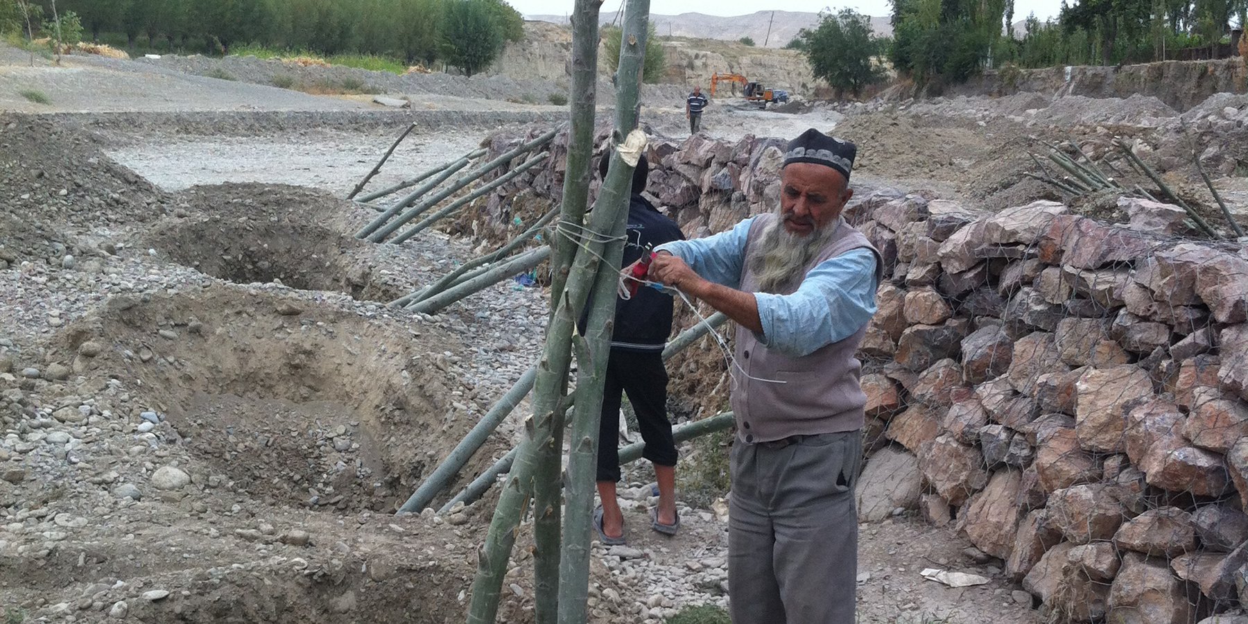
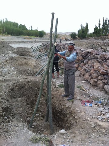
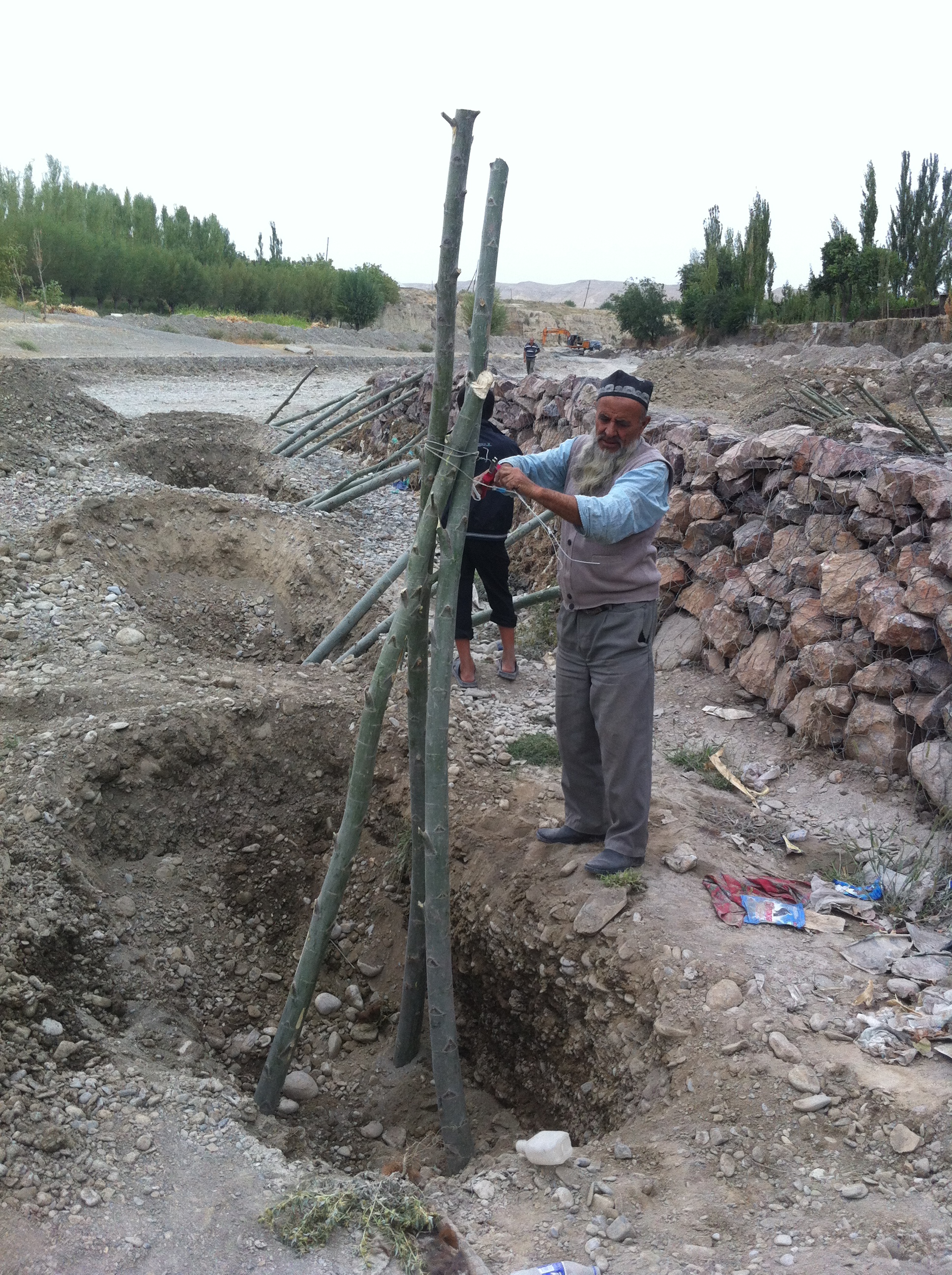
•Planting of single willow saplings in rows immediately behind stone dykes;
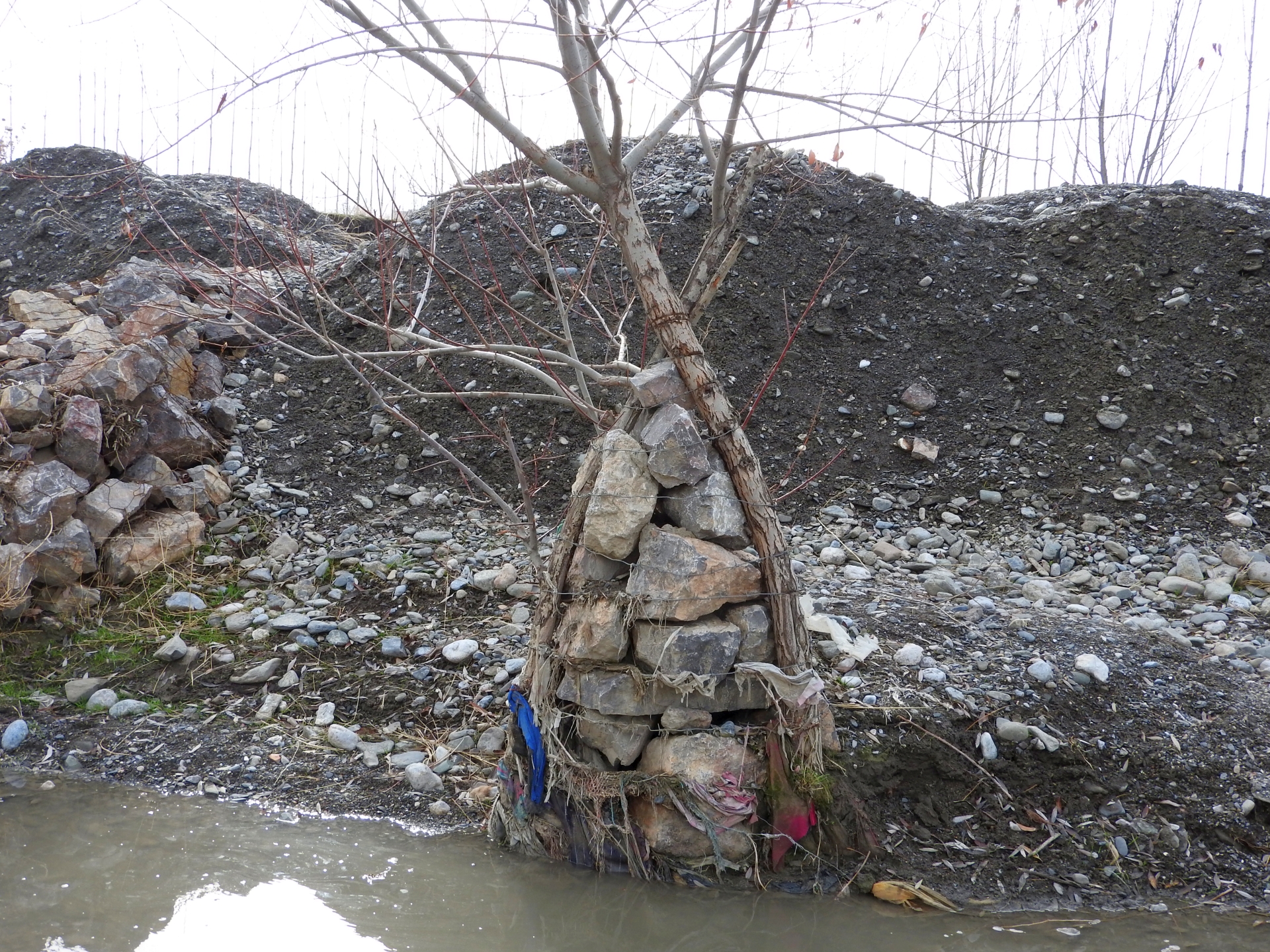
•Planting of willows in form of one or several rows of three seedlings per spot, connected with cords to “tripods” to increase stability;
•Planting of willows in form of one or several rows of three seedlings per spot, connected with cords to “tripods” around a small gabion, which additionally increases the resistance of the planted willows against the forces of water and debris.
The works have been overseen by the GIZ engineer, GIZ also covered expenses for gabion nets and machinery, while willow branches and labor were provided by the communities.
After up to five years the riverbank protection is still functional at all sites and prevented damage from floods to lives and property. No substantial damage occurred to the erected structures despite several heavy flashflood and debris flow events at all sites. Most planted willows established well, have substantially grown and provide an increasingly effective protection. In few spots willows dried up, where washed out or damaged by livestock and replanting would be necessary to maintain the effectiveness of the riverbank protection. In the future the willows can be used as coppice wood with their large branches cut, providing new planting material for additional “green” protection measures, for construction and as fuel. Additionally the willows contribute to the local biodiversity by providing habitat for birds and other animals, improve the microclimate and improve the view of the villages and the landscape. The multiple benefits from the “green” measures are expected to motivate care by the villagers, in particular prevention of damage caused by livestock and insufficient water supply and replanting of lost trees.
2.3 รูปภาพของเทคโนโลยี
อัลบั้มสื่อบันทึก
2.5 ประเทศภูมิภาค หรือสถานที่ตั้งที่เทคโนโลยีได้นำไปใช้และได้รับการครอบคลุมโดยการประเมินนี้
ประเทศ:
ทาจิกิสถาน
ภูมิภาค/รัฐ/จังหวัด:
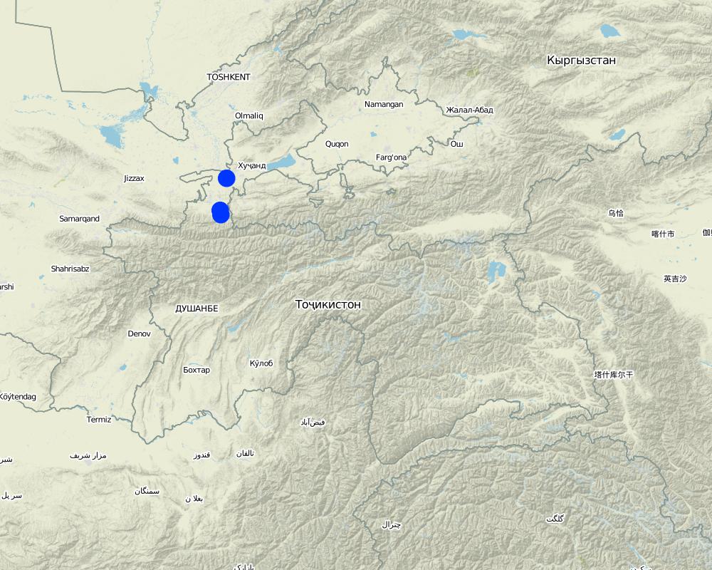
Sughd region
ข้อมูลจำเพาะเพิ่มเติมของสถานที่ตั้ง :
Spitamen district, Devashtich district
ระบุการกระจายตัวของเทคโนโลยี:
- ใช้ ณ จุดที่เฉพาะเจาะจงหรือเน้นไปยังบริเวณพื้นที่ขนาดเล็ก
Is/are the technology site(s) located in a permanently protected area?
ไม่ใช่
Map
×2.6 วันที่การดำเนินการ
ระบุปีที่ใช้:
2013
ถ้าไม่รู้ปีที่แน่นอน ให้ระบุวันที่โดยประมาณ:
- น้อยกว่า 10 ปี (ไม่นานนี้)
2.7 คำแนะนำของเทคโนโลยี
ให้ระบุว่าเทคโนโลยีถูกแนะนำเข้ามาอย่างไร:
- ทางโครงการหรือจากภายนอก
- on request of local Committee for Emergency Situations
3. การจัดประเภทของเทคโนโลยี SLM
3.1 วัตถุประสงค์หลักของเทคโนโลยี
- ลดความเสี่ยงของภัยพิบัติ
- ชะลอการเปลี่ยนแปลงภูมิอากาศของโลกและผลกระทบ
- สร้างผลกระทบทางด้านสังคมที่เป็นประโยชน์
3.2 ประเภทของการใช้ที่ดินในปัจจุบันที่ได้นำเทคโนโลยีไปใช้

ป่า/พื้นที่ทำไม้
- Single trees, tree rows
- Salix spec.
Are the trees specified above deciduous or evergreen?
- deciduous
ผลิตภัณฑ์และบริการ:
- ไม้ที่นำมาทำเป็นเชื้อเพลิง
- การแทะเล็มหญ้า / การเก็บกินหญ้า
- การอนุรักษ์ / ป้องกันธรรมชาติ
- นันทนาการ / การท่องเที่ยว
- การป้องกันภัยธรรมชาติ

การตั้งถิ่นฐาน โครงสร้างพื้นฐาน
- การตั้งถิ่นฐาน ตึกอาคาร
- การจราจร ทางถนน รถไฟ

ทางน้ำ แหล่งน้ำ พื้นที่ชุ่มน้ำ
- ทางระบายน้ำ ทางน้ำ
3.3 Has land use changed due to the implementation of the Technology?
ทางน้ำ แหล่งน้ำ พื้นที่ชุ่มน้ำ
- ทางระบายน้ำ ทางน้ำ

ที่ดินที่ไม่ให้ผลผลิต
3.4 การใช้น้ำ
การใช้น้ำของที่ดินที่มีการใช้เทคโนโลยีอยู่:
- น้ำฝนร่วมกับการชลประทาน
แสดงความคิดเห็น:
River channel with seasonal/episodical flow. Willows partly supported with improvised irrigation.
3.5 กลุ่ม SLM ที่ตรงกับเทคโนโลยีนี้
- การลดความเสี่ยงจากภัยพิบัติบนพื้นฐานของระบบนิเวศ
3.6 มาตรการ SLM ที่ประกอบกันเป็นเทคโนโลยี

มาตรการอนุรักษ์ด้วยวิธีพืช
- V1: ต้นไม้และพุ่มไม้คลุมดิน

มาตรการอนุรักษ์ด้วยโครงสร้าง
- S5: เขื่อน ชั้นดินที่แน่นแข็งบ่อน้ำ
- S11: อื่น ๆ
3.7 รูปแบบหลักของการเสื่อมโทรมของที่ดินที่ได้รับการแก้ไขโดยเทคโนโลยี

การกัดกร่อนของดินโดยน้ำ
- Wr (Riverbank erosion): การกัดกร่อนริมฝั่งแม่น้ำ
3.8 การป้องกัน การลดลง หรือการฟื้นฟูความเสื่อมโทรมของที่ดิน
ระบุเป้าหมายของเทคโนโลยีกับความเสื่อมโทรมของที่ดิน:
- ป้องกันความเสื่อมโทรมของที่ดิน
- ฟื้นฟูบำบัดที่ดินที่เสื่อมโทรมลงอย่างมาก
4. ข้อมูลจำเพาะด้านเทคนิค กิจกรรมการนำไปปฏิบัติใช้ ปัจจัยนำเข้า และค่าใช้จ่าย
4.1 แบบแปลนทางเทคนิคของเทคโนโลยี
ข้อมูลจำเพาะด้านเทคนิค (แบบแปลนทางเทคนิคของเทคโนโลยี):
Scheme how over time "green" and "grey" measures are functional.
ผู้เขียน:
Nodir Muhidinov
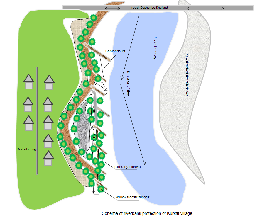
ผู้เขียน:
Nodir Muhidinov, modified by Stefan Michel
วันที่:
11/01/2019
4.2 ข้อมูลทั่วไปเกี่ยวกับการคำนวณปัจจัยนำเข้าและค่าใช้จ่าย
อื่นๆ หรือสกุลเงินประจำชาติ (ระบุ):
TJS
If relevant, indicate exchange rate from USD to local currency (e.g. 1 USD = 79.9 Brazilian Real): 1 USD =:
6.0
4.3 กิจกรรมเพื่อการจัดตั้ง
| กิจกรรม | Timing (season) | |
|---|---|---|
| 1. | Modification of river channel | Fall |
| 2. | Erection of stone dykes and spurs | Fall |
| 3. | Building of gabions | Fall |
| 4. | Planting of willow trees, "tripods" | Fall |
4.4 ค่าใช้จ่ายของปัจจัยนำเข้าที่จำเป็นสำหรับการจัดตั้ง
| ปัจจัยนำเข้า | หน่วย | ปริมาณ | ค่าใช้จ่ายต่อหน่วย | ค่าใช้จ่ายทั้งหมดต่อปัจจัยนำเข้า | %ของค่าใช้จ่ายที่ก่อให้เกิดขึ้นโดยผู้ใช้ที่ดิน | |
|---|---|---|---|---|---|---|
| แรงงาน | Construction of tripod from a willow tree and gabion net | pieces | 46.0 | |||
| แรงงาน | Constrcution of gabion spurs | m³ | 381.0 | |||
| แรงงาน | Laying down gabion net | m² | 812.4 | |||
| อุปกรณ์ | Excavator | m³ | 1800.0 | |||
| อุปกรณ์ | Buldozer | m³ | 7040.0 | |||
| วัสดุด้านพืช | willow tree tripods | pieces | 46.0 | |||
| วัสดุสำหรับก่อสร้าง | Gabion net | m² | 812.4 | |||
| วัสดุสำหรับก่อสร้าง | Stones for gabions | m³ | 381.0 |
If you are unable to break down the costs in the table above, give an estimation of the total costs of establishing the Technology:
124690.0
ถ้าผู้ใช้ที่ดินรับภาระน้อยกว่า 100% ของค่าใช้จ่าย ให้ระบุว่าใครเป็นผู้รับผิดชอบส่วนที่เหลือ:
GIZ: Transportation, procurement of materials (as specified) and lead worker fee: 87,940 TJS (13,224 EUR, 70 %); Community: Labour (manual works): 36,722 TJS (5,522 EUR; 30%)
แสดงความคิดเห็น:
This is an example from one area in Devashtich district. The costs are varying and depend on the specific local circumstances. The addition of "green" measures increases the required labour, but does not substantially increase the overall costs.
4.5 การบำรุงรักษาสภาพหรือกิจกรรมที่เกิดขึ้นเป็นประจำ
| กิจกรรม | ช่วงระยะเวลา/ความถี่ | |
|---|---|---|
| 1. | Prevention of damage to trees from livestock | Year round |
| 2. | Improvised irrigation | During seasons of low water availability at the planting sites |
| 3. | Closing of washed out places | After damage detected |
| 4. | Replanting | Fall |
4.6 ค่าใช้จ่ายของปัจจัยนำเข้าและกิจกรรมที่เกิดขึ้นเป็นประจำที่ต้องการการบำรุงรักษา (ต่อปี)
แสดงความคิดเห็น:
Maintenance costs are low and can be covered by community contribution of labour.
5. สิ่งแวดล้อมทางธรรมชาติและของมนุษย์
5.1 ภูมิอากาศ
ฝนประจำปี
- < 250 ม.ม.
- 251-500 ม.ม.
- 501-750 ม.ม.
- 751-1,000 ม.ม.
- 1,001-1,500 ม.ม.
- 1,501-2,000 ม.ม.
- 2,001-3,000 ม.ม.
- 3,001-4,000 ม.ม.
- > 4,000 ม.ม.
ข้อมูลจำเพาะ/ความคิดเห็นเรื่องปริมาณน้ำฝน:
Rainfall varies between the areas but of relevance is rainfall in the upper catchments, where no reference meteorolgical station exists.
เขตภูมิอากาศเกษตร
- กึ่งชุ่มชื้น
- กึ่งแห้งแล้ง
The climate varies between the areas but of relevance is the climate and weather in the upper catchments.
5.2 สภาพภูมิประเทศ
ค่าเฉลี่ยความลาดชัน:
- ราบเรียบ (0-2%)
- ลาดที่ไม่ชัน (3-5%)
- ปานกลาง (6-10%)
- เป็นลูกคลื่น (11-15%)
- เป็นเนิน (16-30%)
- ชัน (31-60%)
- ชันมาก (>60%)
ธรณีสัณฐาน:
- ที่ราบสูง/ที่ราบ
- สันเขา
- ไหล่เขา
- ไหล่เนินเขา
- ตีนเนิน
- หุบเขา
ระดับความสูง:
- 0-100 เมตร
- 101-500 เมตร
- 501-1,000 เมตร
- 1,001-1,500 เมตร
- 1,501-2,000 เมตร
- 2,001-2,500 เมตร
- 2,501-3,000 เมตร
- 3,001-4,000 เมตร
- > 4,000 เมตร
ให้ระบุถ้าเทคโนโลยีได้ถูกนำไปใช้:
- บริเวณแอ่งบนที่ราบ (concave situations)
5.3 ดิน
ค่าเฉลี่ยความลึกของดิน:
- ตื้นมาก (0-20 ซ.ม.)
- ตื้น (21-50 ซ.ม.)
- ลึกปานกลาง (51-80 ซ.ม.)
- ลึก (81-120 ซ.ม.)
- ลึกมาก (>120 ซ.ม.)
เนื้อดิน (ดินชั้นบน):
- หยาบ/เบา (ดินทราย)
เนื้อดินล่าง (> 20 ซ.ม.ต่ำจากผิวดิน):
- หยาบ/เบา (ดินทราย)
อินทรียวัตถุในดิน:
- ต่ำ (<1%)
(ถ้ามี) ให้แนบคำอธิบายเรื่องดินแบบเต็มหรือระบุข้อมูลที่มีอยู่ เช่น ชนิดของดิน ค่า pH ของดินหรือความเป็นกรดของดิน ความสามารถในการแลกเปลี่ยนประจุบวก ไนโตรเจน ความเค็ม เป็นต้น:
Mainly gravel and sand in riverbeds.
5.4 ความเป็นประโยชน์และคุณภาพของน้ำ
ระดับน้ำใต้ดิน:
<5 เมตร
น้ำไหลบ่าที่ผิวดิน:
ดี
ความเค็มของน้ำเป็นปัญหาหรือไม่:
ไม่ใช่
กำลังเกิดน้ำท่วมในพื้นที่หรือไม่:
ใช่
บ่อยครั้ง:
เป็นครั้งเป็นคราว
5.5 ความหลากหลายทางชีวภาพ
ความหลากหลายทางชนิดพันธุ์:
- ต่ำ
ความหลากหลายของแหล่งที่อยู่:
- ต่ำ
ความคิดเห็นและข้อมูลจำเพาะเพิ่มเติมของความหลากหลายทางชีวภาพ:
Planted trees increase the habitat for biodiversity.
5.6 ลักษณะของผู้ใช้ที่ดินที่นำเทคโนโลยีไปปฏิบัติใช้
อยู่กับที่หรือเร่ร่อน:
- อยู่กับที่
- กึ่งเร่ร่อน
แนวทางการตลาดของระบบการผลิต:
- เพื่อการยังชีพ (หาเลี้ยงตนเอง)
- mixed (subsistence/ commercial)
รายได้ที่มาจากนอกฟาร์ม:
- < 10% ของรายได้ทั้งหมด
- 10-50% ของรายได้ทั้งหมด
ระดับของความมั่งคั่งโดยเปรียบเทียบ:
- พอมีพอกิน
เป็นรายบุคคล/ครัวเรือน:
- เป็นรายบุคคล/ครัวเรือน
- กลุ่ม/ชุมชน
ระดับของการใช้เครื่องจักรกล:
- งานที่ใช้แรงกาย
- การใช้เครื่องจักรหรือเครื่องยนต์
เพศ:
- หญิง
- ชาย
อายุของผู้ใช้ที่ดิน:
- เด็ก
- ผู้เยาว์
- วัยกลางคน
- ผู้สูงอายุ
5.7 Average area of land used by land users applying the Technology
- < 0.5 เฮกตาร์
- 0.5-1 เฮกตาร์
- 1-2 เฮกตาร์
- 2-5 เฮกตาร์
- 5-15 เฮกตาร์
- 15-50 เฮกตาร์
- 50-100 เฮกตาร์
- 100-500 เฮกตาร์
- 500-1,000 เฮกตาร์
- 1,000-10,000 เฮกตาร์
- >10,000 เฮกตาร์
พิจารณาว่าเป็นขนาดเล็ก กลาง หรือขนาดใหญ่ (ซึ่งอ้างอิงถึงบริบทระดับท้องถิ่น):
- ขนาดเล็ก
5.8 กรรมสิทธิ์ในที่ดิน สิทธิในการใช้ที่ดินและสิทธิในการใช้น้ำ
กรรมสิทธิ์ในที่ดิน:
- รัฐ
Are land use rights based on a traditional legal system?
ไม่ใช่
5.9 การเข้าถึงบริการและโครงสร้างพื้นฐาน
สุขภาพ:
- จน
- ปานกลาง
- ดี
การศึกษา:
- จน
- ปานกลาง
- ดี
ความช่วยเหลือทางด้านเทคนิค:
- จน
- ปานกลาง
- ดี
การจ้างงาน (เช่น ภายนอกฟาร์ม):
- จน
- ปานกลาง
- ดี
ตลาด:
- จน
- ปานกลาง
- ดี
พลังงาน:
- จน
- ปานกลาง
- ดี
ถนนและการขนส่ง:
- จน
- ปานกลาง
- ดี
น้ำดื่มและการสุขาภิบาล:
- จน
- ปานกลาง
- ดี
บริการด้านการเงิน:
- จน
- ปานกลาง
- ดี
6. ผลกระทบและสรุปคำบอกกล่าว
6.1 ผลกระทบในพื้นที่ดำเนินการ (On-site) จากการใช้เทคโนโลยี
ผลกระทบทางด้านเศรษฐกิจและสังคม
การผลิต
การผลิตพืชผล
แสดงความคิดเห็น/ระบุ:
Locally additional land reclaimed for fruit trees.
การผลิตไม้
จำนวนก่อน SLM:
0
หลังจาก SLM:
Some
แสดงความคิดเห็น/ระบุ:
Use of willow branches for small construction and as fuel
ผลกระทบทางด้านเศรษฐกิจและสังคมอื่น ๆ
Damage from disasters
จำนวนก่อน SLM:
High damage
หลังจาก SLM:
Low or zero damage
ผลกระทบด้านนิเวศวิทยา
ลดความเสี่ยงของภัยพิบัติ
ดินถล่ม/ ซากต่าง ๆ ที่ถูกพัดพามา
แสดงความคิดเห็น/ระบุ:
Effective protection against medium and large events, potentially no full protection in case of extreme events.
ผลกระทบด้านนิเวศวิทยาอื่น ๆ
Greening, biodiversity
แสดงความคิดเห็น/ระบุ:
Local improvement due to trees planted
6.2 ผลกระทบนอกพื้นที่ดำเนินการ (Off-site) จากการใช้เทคโนโลยี
ความเสียหายต่อพื้นที่เพาะปลูกของเพื่อนบ้าน
แสดงความคิดเห็น/ระบุ:
Redirected river channel can locally cause lateral erosion.
6.3 การเผชิญและความตอบสนองของเทคโนโลยีต่อการเปลี่ยนแปลงสภาพภูมิอากาศที่ค่อยเป็นค่อยไป และสภาพรุนแรงของภูมิอากาศ / ภัยพิบัติ (ที่รับรู้ได้โดยผู้ใช้ที่ดิน)
สภาพรุนแรงของภูมิอากาศ (ภัยพิบัติ)
ภัยพิบัติจากน้ำ
| เทคโนโลยีมีวิธีการรับมืออย่างไร | |
|---|---|
| น้ำท่วมฉับพลัน | ดี |
6.4 การวิเคราะห์ค่าใช้จ่ายและผลประโยชน์ที่ได้รับ
ผลประโยชน์ที่ได้รับเปรียบเทียบกับค่าใช้จ่ายในการจัดตั้งเป็นอย่างไร (จากมุมมองของผู้ใช้ที่ดิน)
ผลตอบแทนระยะสั้น:
ด้านบวก
ผลตอบแทนระยะยาว:
ด้านบวกอย่างมาก
ผลประโยชน์ที่ได้รับเปรียบเทียบกับค่าใช้จ่ายในการบำรุงรักษาหรือต้นทุนที่เกิดขึ้นซ้ำอีก เป็นอย่างไร (จากมุมมองของผู้ใช้ที่ดิน)
ผลตอบแทนระยะสั้น:
ด้านบวกอย่างมาก
ผลตอบแทนระยะยาว:
ด้านบวกอย่างมาก
6.5 การปรับตัวของเทคโนโลยี
- ครั้งเดียวหรือเป็นการทดลอง
Of all those who have adopted the Technology, how many did so spontaneously, i.e. without receiving any material incentives/ payments?
- 0-10%
แสดงความคิดเห็น:
Disaster risk reduction measures require for their implementation external financial assistance.
6.6 การปรับตัว
เทคโนโลยีได้รับการปรับเปลี่ยนเมื่อเร็วๆนี้ เพื่อให้ปรับตัวเข้ากับสภาพที่กำลังเปลี่ยนแปลงหรือไม่:
ใช่
ถ้าตอบว่าใช่ ให้ระบุว่าเงื่อนไขการเปลี่ยนแปลงใดที่ถูกปรับตัว:
- การเปลี่ยนแปลงแบบค่อยเป็นค่อยไปและสภาพรุนแรงของภูมิอากาศ
ให้ระบุการปรับตัวของเทคโนโลยี (การออกแบบ วัสดุหรือชนิดพันธุ์ เป็นต้น):
Instead of planting single trees "tripods" are planted. The "tripods" are stabilized by small gabions.
6.7 จุดแข็ง / ข้อได้เปรียบ / โอกาสของเทคโนโลยี
| จุดแข็ง / ข้อได้เปรียบ / โอกาสในทัศนคติของผู้ใช้ที่ดิน |
|---|
| Long term sustainability. |
| Low costs. |
| Low maintenance needs. |
| Additional benefits (greening, wood). |
| จุดแข็ง / ข้อได้เปรียบ / โอกาสในทัศนคติของผู้รวบรวมหรือวิทยากรหลัก |
|---|
| Same as land-users' view. |
| Increases lifetime of structural measures. As gabions lose stability due to aging of the gabion nets, the tree "tripods" gain stabilizing features. |
6.8 จุดอ่อน / ข้อเสียเปรียบ / ความเสี่ยงของเทคโนโลยีและวิธีการแก้ไข
| จุดอ่อน / ข้อเสียเปรียบ / ความเสี่ยงในทัศนคติของผู้ใช้ที่ดิน | มีวิธีการแก้ไขได้อย่างไร |
|---|---|
| None |
| จุดอ่อน / ข้อเสียเปรียบ / ความเสี่ยงในทัศนคติของผู้รวบรวมหรือวิทยากรหลัก | มีวิธีการแก้ไขได้อย่างไร |
|---|---|
| Trees can be damaged by livestock | Community members need to be motivated to prevent damage and to replace dry trees. |
| During the first years trees can dry up if not enough water is available | Community members need to be improvise irrigation when necessary and possible and should replace dry trees. |
7. การอ้างอิงและการเชื่อมต่อ
7.1 วิธีการและแหล่งข้อมูล
- ไปเยี่ยมชมภาคสนาม การสำรวจพื้นที่ภาคสนาม
- การสัมภาษณ์กับผู้ใช้ที่ดิน
- การสัมภาษณ์ผู้เชี่ยวชาญด้าน SLM หรือผู้ชำนาญ
- การเก็บรวบรวมมาจากรายงานและเอกสารที่มีอยู่
วันที่เก็บรวบรวมข้อมูล(ภาคสนาม) :
27/11/2018
แสดงความคิดเห็น:
27 and 28 November 2018
ลิงก์และโมดูล
ขยายทั้งหมด ย่อทั้งหมดลิงก์
Integrated disaster risk reduction in flood-affected areas by … [ทาจิกิสถาน]
Climate change and land degradation in upper catchment areas cause an increasing frequency and intensity of flash flood and debris flows affecting settlements and productive areas. GIZ in collaboration with the Committee on Emergency Situations assisted local communities in the implementation of integrated preventive measures.
- ผู้รวบรวม: Stefan Michel
โมดูล
ไม่มีโมดูล