Prevention of riverbank erosion by combination of green and grey measures [塔吉克斯坦]
- 创建:
- 更新:
- 编制者: Stefan Michel
- 编辑者: –
- 审查者: Umed Vahobov
Защита берега реки путем комбинации строений и посадок
technologies_4311 - 塔吉克斯坦
查看章节
全部展开 全部收起1. 一般信息
1.2 参与该技术评估和文件编制的资源人员和机构的联系方式
关键资源人
SLM专业人员:
Nodir Muhidinov
Deutsche Gesellschaft für Internationale Zusammenarbeit (GIZ)
塔吉克斯坦
有助于对技术进行记录/评估的项目名称(如相关)
Strengthening of Livelihoods through Climate Change Adaptation in Kyrgyzstan and Tajikistan有助于对技术进行记录/评估的机构名称(如相关)
Deutsche Gesellschaft für Internationale Zusammenarbeit - Tajikistan (GIZ Tajikistan) - 塔吉克斯坦1.3 关于使用通过WOCAT记录的数据的条件
编制者和关键资源人员接受有关使用通过WOCAT记录数据的条件。:
是
1.4 所述技术的可持续性声明
这里所描述的技术在土地退化方面是否存在问题,导致无法被认为是一种可持续的土地管理技术?:
否
1.5 参考关于SLM方法(使用WOCAT记录的SLM方法)的调查问卷
Integrated disaster risk reduction in flood-affected areas by … [塔吉克斯坦]
Climate change and land degradation in upper catchment areas cause an increasing frequency and intensity of flash flood and debris flows affecting settlements and productive areas. GIZ in collaboration with the Committee on Emergency Situations assisted local communities in the implementation of integrated preventive measures.
- 编制者: Stefan Michel
2. SLM技术的说明
2.1 技术简介
技术定义:
Flashfloods in riverbeds cause intensive riverbank erosion, which threatens villages, infrastructure and productive lands. Preventive measures combining "grey" (physical structures) and "green" (living trees) elements are more effective, sustainable and cost efficient than constructive measures only.
2.2 技术的详细说明
说明:
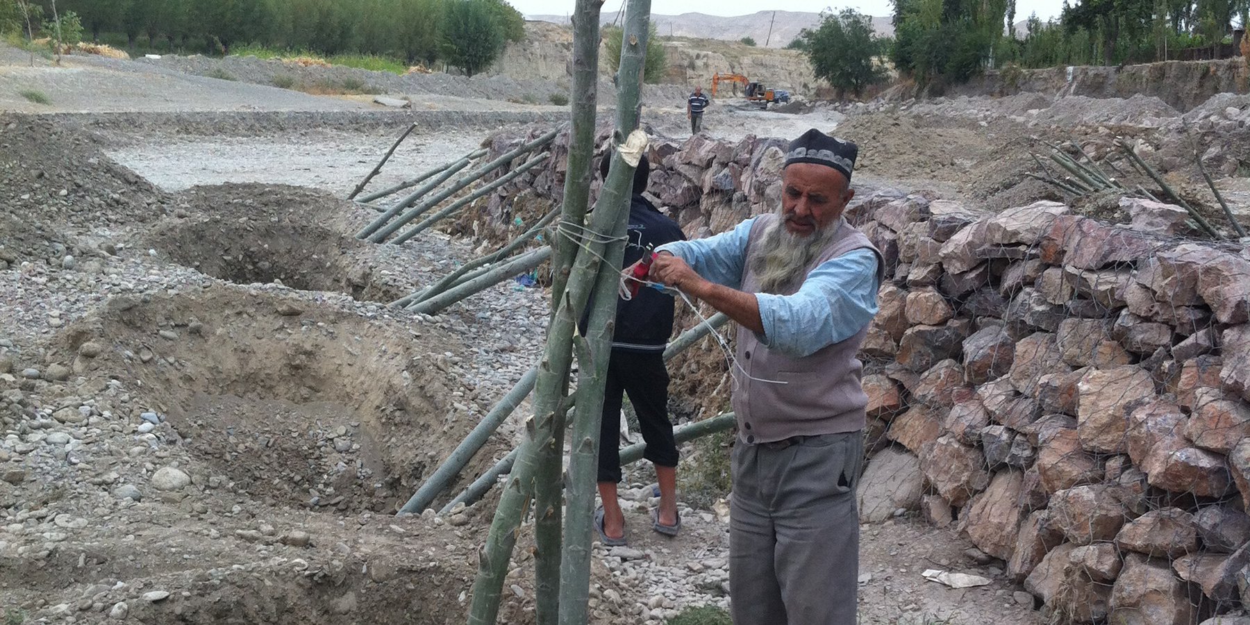
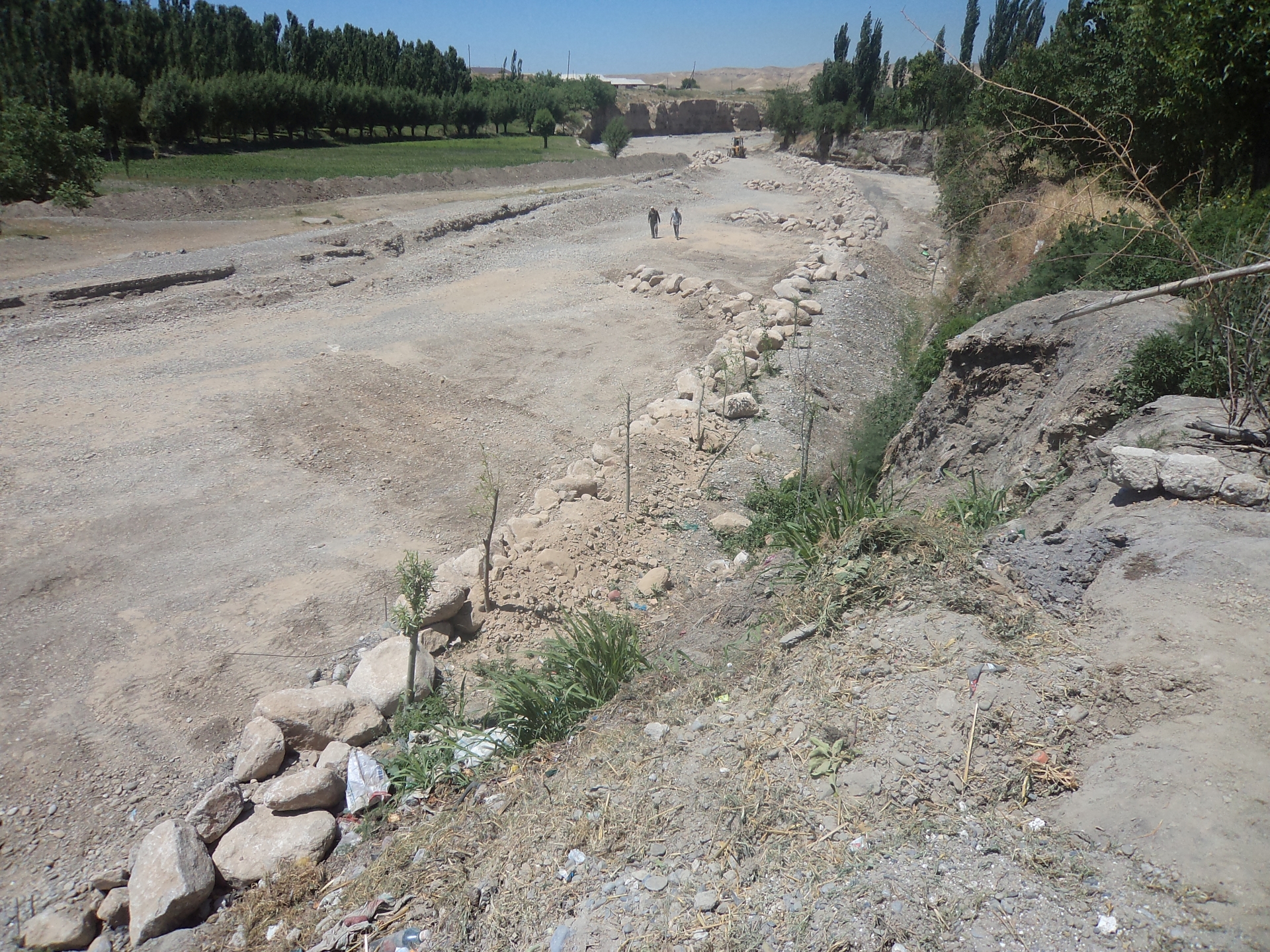
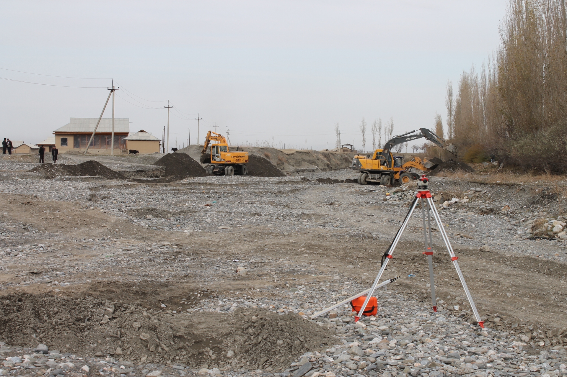
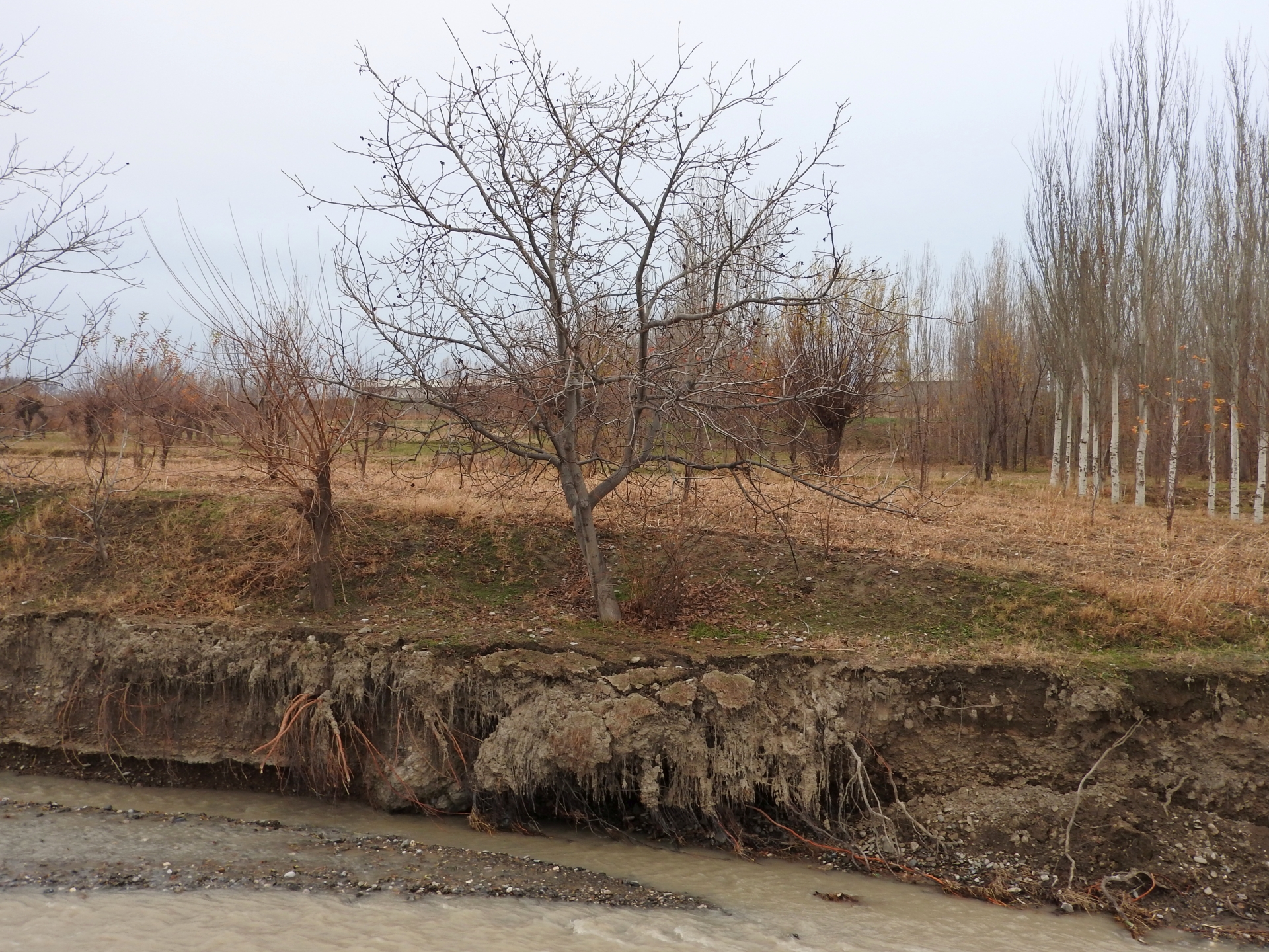
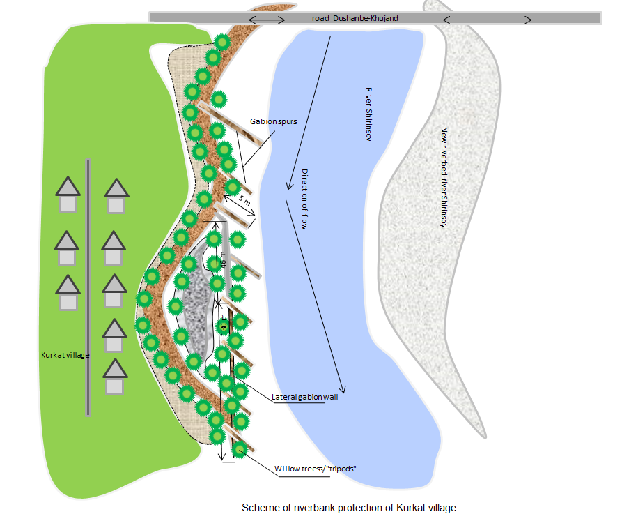
Villages at the northern slopes of the Turkestan range in Sughd region are often located at riverbanks. The amounts of water flowing in the river channels naturally varies much during the year. After intensive rainfall or snowmelt the water flow can suddenly increase manifold. These flashfloods carry huge amounts of debris and are therefore even more destructive. The combined effects of degradation of woodlands and rangelands in the upper catchments and the impact of climate change with accelerated snowmelt and higher frequency and intensity of heavy rainfall events have increased the risks of these debris flows. In several villages of Sughd region, especially in Spitamen and Devashtich districts, riverbank erosion during flashflood and debris flows increasingly threatened houses, infrastructure and productive lands.
GIZ in collaboration with the local branches of the Committee for Emergency Situations, district and sub-district authorities assisted local community in the implementation of riverbank protection measures. The design of the protective structure was specifically adapted to the local situation. For achieving immediately reliable protection structural measures (“grey”) included:
•Modification of river channels with excavators and bulldozers to redirect flows;
•Erection of dykes and spurs from large rocks along erosion prone riverbanks;
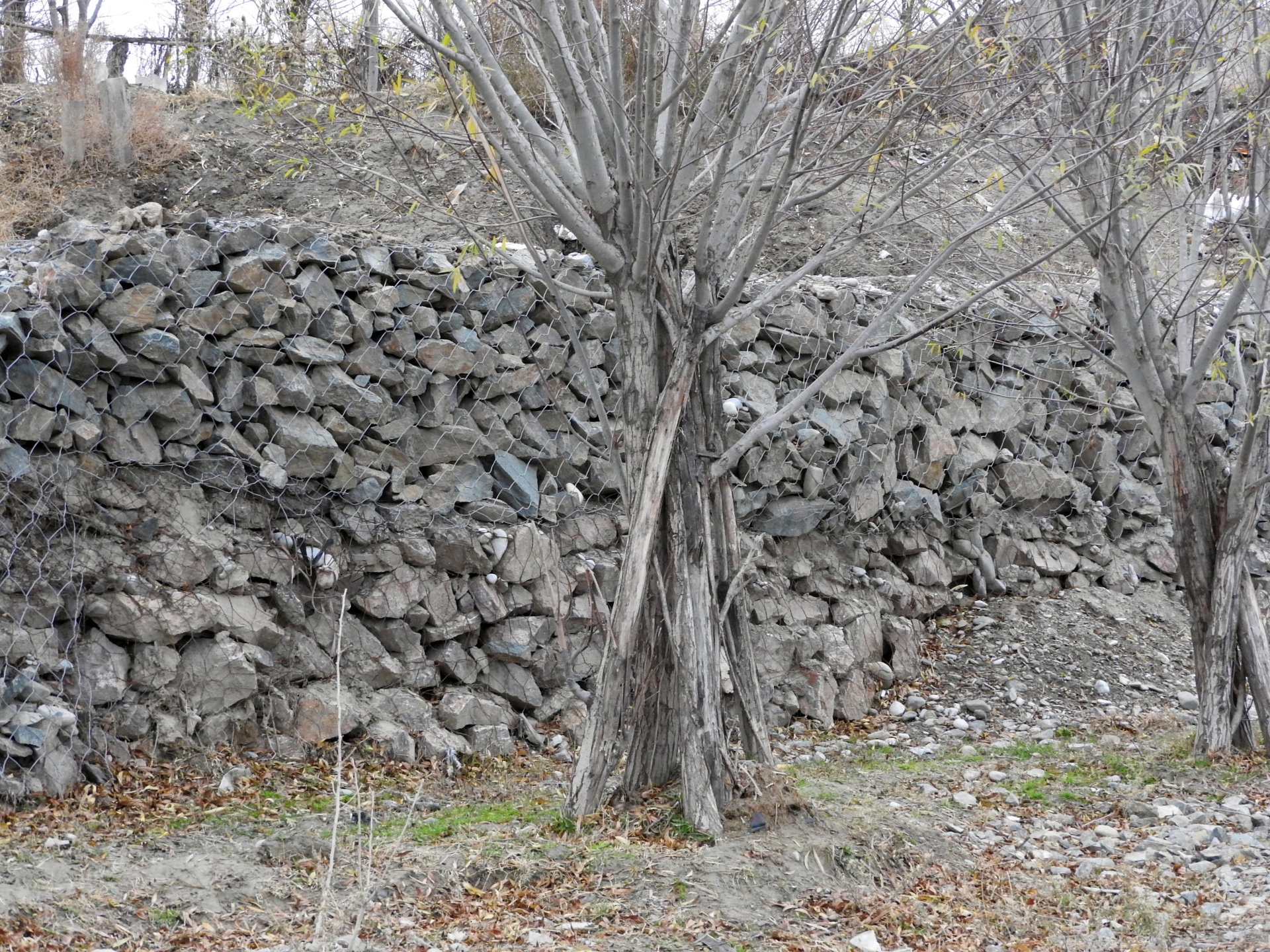
•Erection of lateral gabion walls along erosion prone riverbanks;
•Erection of gabion spurs, which concentrate the water flow in the center of the river channel and thus reduce the force of water and debris on riverbanks and lateral gabion walls.
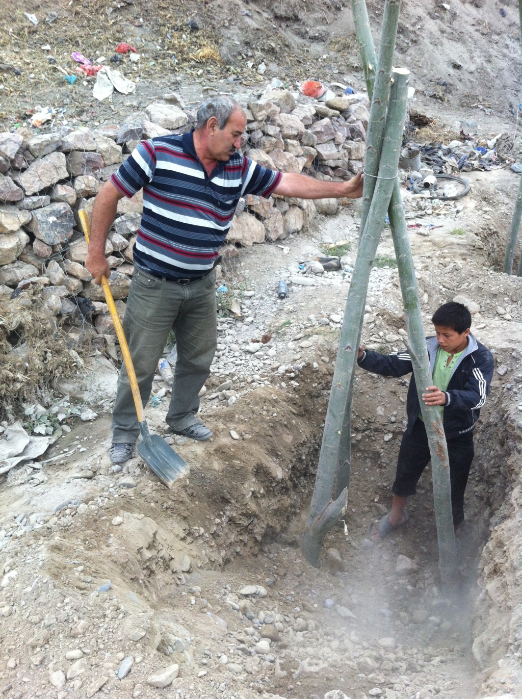
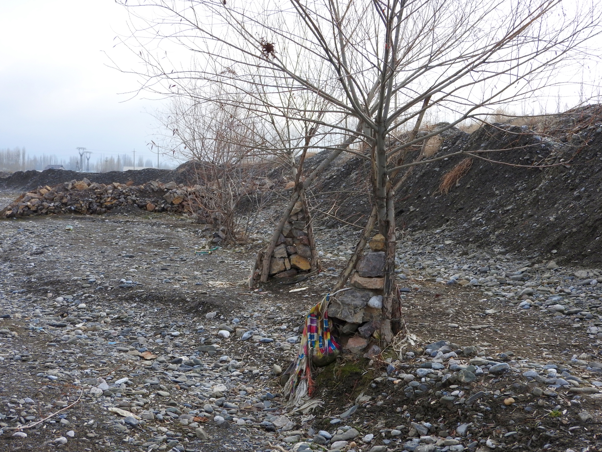
In the long run “grey” measures tend to be damaged by flashfloods and debris flows. “Green” measures can enforce the protective structures and thus increase the sustainability, effectiveness and cost efficiency of structural measures. Willows are particularly suitable for erosion prevention in river channels as they grow fast, establish a large fixing root system in the riverbed, their wood is flexible and withstands intensive force and they well regenerate after damage. “Green” measures for reinforcing riverbank protection included:
•Planting of single willow saplings in rows immediately behind stone dykes;
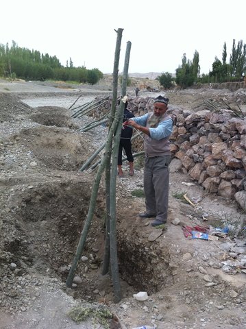
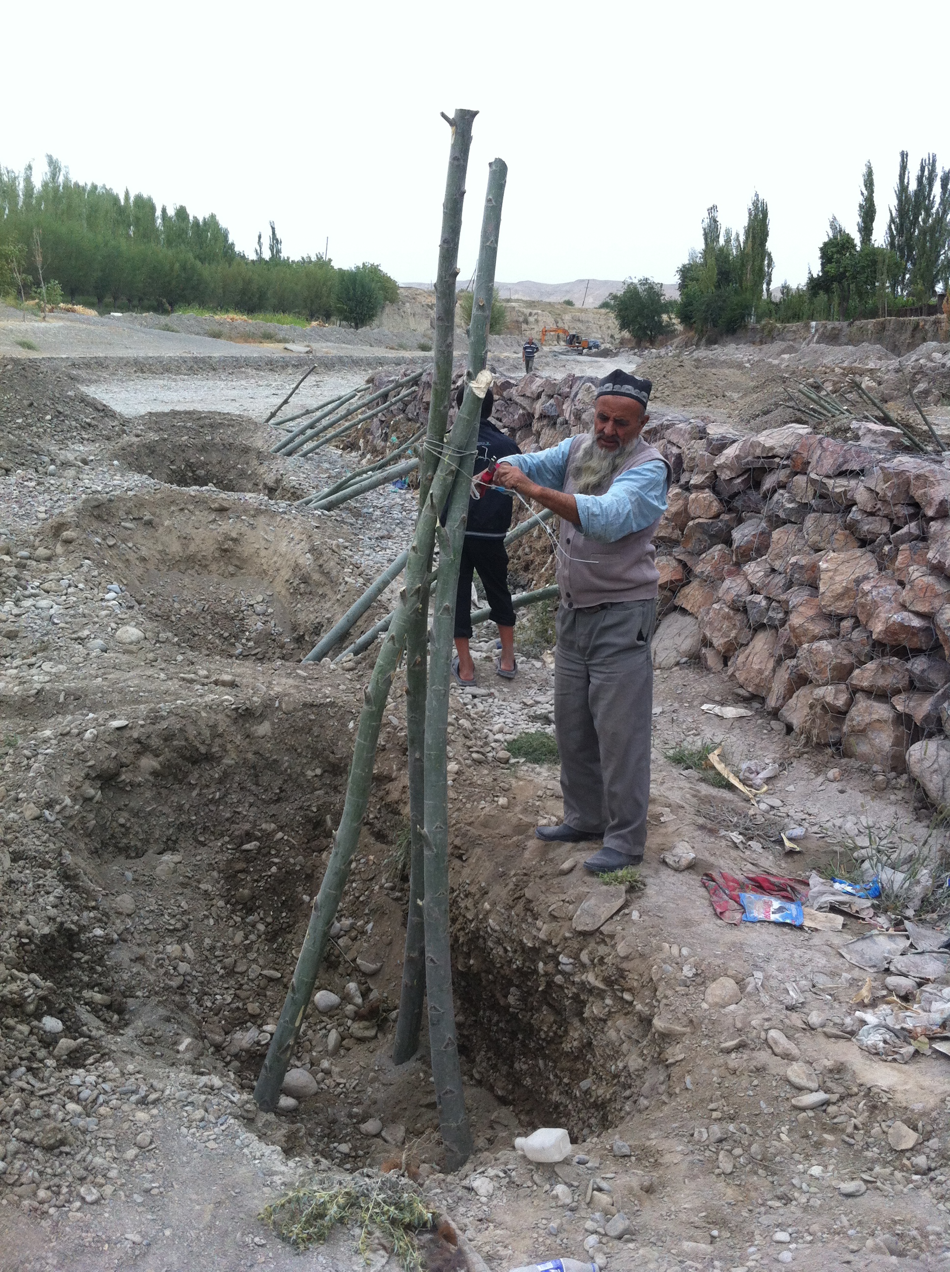
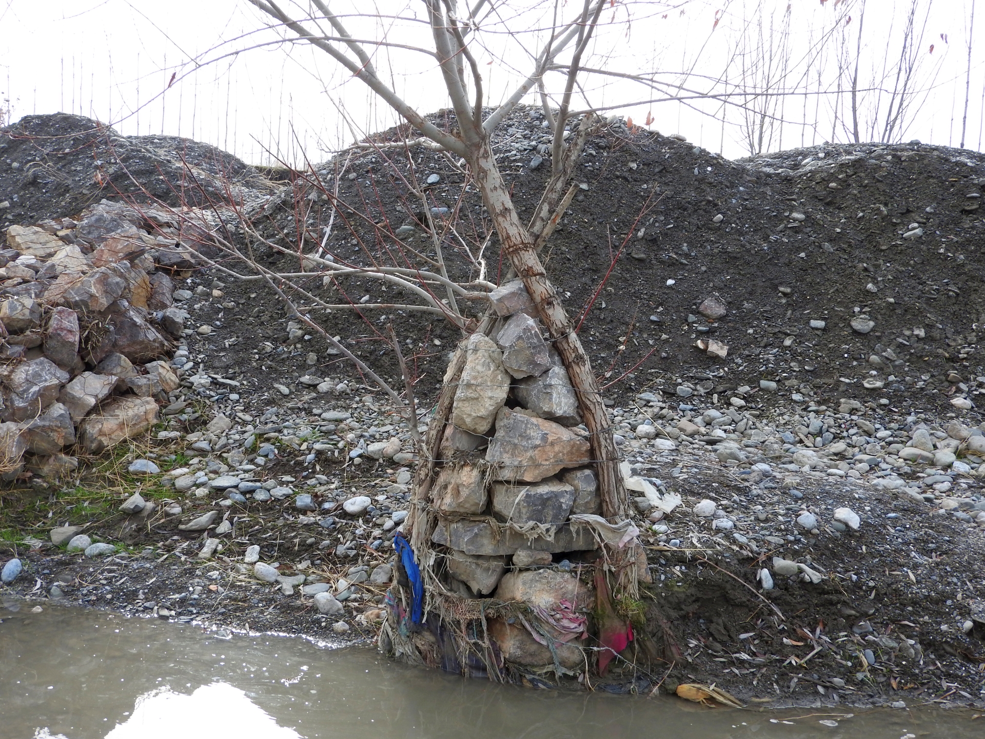
•Planting of willows in form of one or several rows of three seedlings per spot, connected with cords to “tripods” to increase stability;
•Planting of willows in form of one or several rows of three seedlings per spot, connected with cords to “tripods” around a small gabion, which additionally increases the resistance of the planted willows against the forces of water and debris.
The works have been overseen by the GIZ engineer, GIZ also covered expenses for gabion nets and machinery, while willow branches and labor were provided by the communities.
After up to five years the riverbank protection is still functional at all sites and prevented damage from floods to lives and property. No substantial damage occurred to the erected structures despite several heavy flashflood and debris flow events at all sites. Most planted willows established well, have substantially grown and provide an increasingly effective protection. In few spots willows dried up, where washed out or damaged by livestock and replanting would be necessary to maintain the effectiveness of the riverbank protection. In the future the willows can be used as coppice wood with their large branches cut, providing new planting material for additional “green” protection measures, for construction and as fuel. Additionally the willows contribute to the local biodiversity by providing habitat for birds and other animals, improve the microclimate and improve the view of the villages and the landscape. The multiple benefits from the “green” measures are expected to motivate care by the villagers, in particular prevention of damage caused by livestock and insufficient water supply and replanting of lost trees.
2.3 技术照片
媒体库
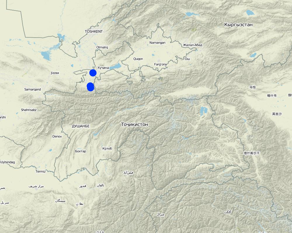
2.5 已应用该技术的、本评估所涵盖的国家/地区/地点
国家:
塔吉克斯坦
区域/州/省:
Sughd region
有关地点的进一步说明:
Spitamen district, Devashtich district
具体说明该技术的分布:
- 适用于特定场所/集中在较小区域
技术现场是否位于永久保护区?:
否
Map
×2.6 实施日期
注明实施年份:
2013
如果不知道确切的年份,请说明大概的日期:
- 不到10年前(最近)
2.7 技术介绍
详细说明该技术是如何引入的:
- 通过项目/外部干预
- on request of local Committee for Emergency Situations
3. SLM技术的分类
3.1 该技术的主要目的
- 降低灾害风险
- 减缓气候变化及其影响
- 创造有益的社会影响
3.2 应用该技术的当前土地利用类型

森林/林地
- Single trees, tree rows
- Salix spec.
以上的树木是落叶树还是常绿树?:
- 落叶植物
产品和服务:
- 薪材
- 放牧/啃牧
- 自然保持/保护
- 娱乐/旅游
- 自然灾害防护

定居点、基础设施
- 定居点、建筑物
- 交通:公路、铁路

水道、水体、湿地
- 排水管道、水道
3.3 由于技术的实施,土地使用是否发生了变化?
水道、水体、湿地
- 排水管道、水道

不毛之地
3.4 供水
该技术所应用土地的供水:
- 混合雨水灌溉
注释:
River channel with seasonal/episodical flow. Willows partly supported with improvised irrigation.
3.5 该技术所属的SLM组
- 减少基于生态系统的灾害风险
3.6 包含该技术的可持续土地管理措施

植物措施
- V1:乔木和灌木覆盖层

结构措施
- S5:大坝、集水斗、水池
- S11:其它
3.7 该技术强调的主要土地退化类型

土壤水蚀
- Wr:河岸侵蚀
3.8 防止、减少或恢复土地退化
具体数量名该技术与土地退化有关的目标:
- 防止土地退化
- 修复/恢复严重退化的土地
4. 技术规范、实施活动、投入和成本
4.1 该技术的技术图纸
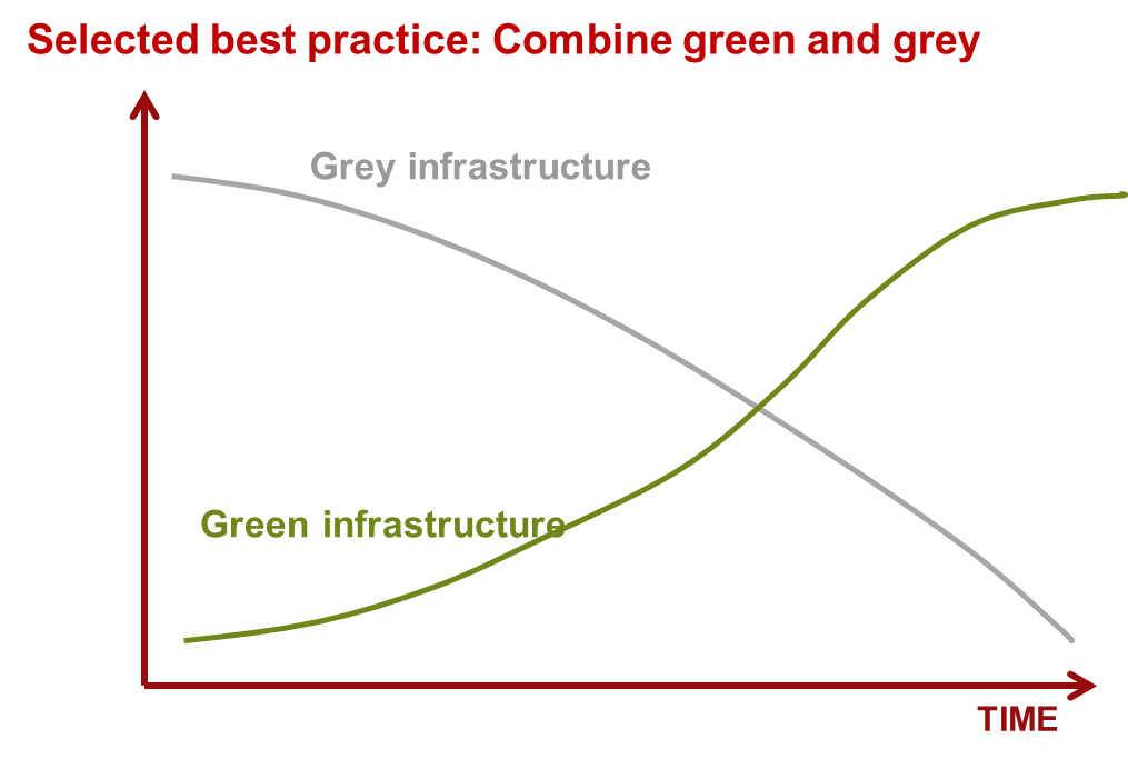
技术规范(与技术图纸相关):
Scheme how over time "green" and "grey" measures are functional.
作者:
Nodir Muhidinov
作者:
Nodir Muhidinov, modified by Stefan Michel
日期:
11/01/2019
4.2 有关投入和成本计算的一般信息
其它/国家货币(具体说明):
TJS
如相关,注明美元与当地货币的汇率(例如1美元=79.9巴西雷亚尔):1美元=:
6.0
4.3 技术建立活动
| 活动 | 时间(季度) | |
|---|---|---|
| 1. | Modification of river channel | Fall |
| 2. | Erection of stone dykes and spurs | Fall |
| 3. | Building of gabions | Fall |
| 4. | Planting of willow trees, "tripods" | Fall |
4.4 技术建立所需要的费用和投入
| 对投入进行具体说明 | 单位 | 数量 | 单位成本 | 每项投入的总成本 | 土地使用者承担的成本% | |
|---|---|---|---|---|---|---|
| 劳动力 | Construction of tripod from a willow tree and gabion net | pieces | 46.0 | |||
| 劳动力 | Constrcution of gabion spurs | m³ | 381.0 | |||
| 劳动力 | Laying down gabion net | m² | 812.4 | |||
| 设备 | Excavator | m³ | 1800.0 | |||
| 设备 | Buldozer | m³ | 7040.0 | |||
| 植物材料 | willow tree tripods | pieces | 46.0 | |||
| 施工材料 | Gabion net | m² | 812.4 | |||
| 施工材料 | Stones for gabions | m³ | 381.0 |
如果您无法分解上表中的成本,请估算建立该技术所需要的总成本。:
124690.0
如果土地使用者负担的费用少于100%,请注明由谁负担其余费用:
GIZ: Transportation, procurement of materials (as specified) and lead worker fee: 87,940 TJS (13,224 EUR, 70 %); Community: Labour (manual works): 36,722 TJS (5,522 EUR; 30%)
注释:
This is an example from one area in Devashtich district. The costs are varying and depend on the specific local circumstances. The addition of "green" measures increases the required labour, but does not substantially increase the overall costs.
4.5 维护/经常性活动
| 活动 | 时间/频率 | |
|---|---|---|
| 1. | Prevention of damage to trees from livestock | Year round |
| 2. | Improvised irrigation | During seasons of low water availability at the planting sites |
| 3. | Closing of washed out places | After damage detected |
| 4. | Replanting | Fall |
4.6 维护/经常性活动所需要的费用和投入(每年)
注释:
Maintenance costs are low and can be covered by community contribution of labour.
5. 自然和人文环境
5.1 气候
年降雨量
- < 250毫米
- 251-500毫米
- 501-750毫米
- 751-1,000毫米
- 1,001-1,500毫米
- 1,501-2,000毫米
- 2,001-3,000毫米
- 3,001-4,000毫米
- > 4,000毫米
有关降雨的规范/注释:
Rainfall varies between the areas but of relevance is rainfall in the upper catchments, where no reference meteorolgical station exists.
农业气候带
- 半湿润
- 半干旱
The climate varies between the areas but of relevance is the climate and weather in the upper catchments.
5.2 地形
平均坡度:
- 水平(0-2%)
- 缓降(3-5%)
- 平缓(6-10%)
- 滚坡(11-15%)
- 崎岖(16-30%)
- 陡峭(31-60%)
- 非常陡峭(>60%)
地形:
- 高原/平原
- 山脊
- 山坡
- 山地斜坡
- 麓坡
- 谷底
垂直分布带:
- 0-100 m a.s.l.
- 101-500 m a.s.l.
- 501-1,000 m a.s.l.
- 1,001-1,500 m a.s.l.
- 1,501-2,000 m a.s.l.
- 2,001-2,500 m a.s.l.
- 2,501-3,000 m a.s.l.
- 3,001-4,000 m a.s.l.
- > 4,000 m a.s.l.
说明该技术是否专门应用于:
- 凹陷情况
5.3 土壤
平均土层深度:
- 非常浅(0-20厘米)
- 浅(21-50厘米)
- 中等深度(51-80厘米)
- 深(81-120厘米)
- 非常深(> 120厘米)
土壤质地(表土):
- 粗粒/轻(砂质)
土壤质地(地表以下> 20厘米):
- 粗粒/轻(砂质)
表土有机质:
- 低(<1%)
如有可能,附上完整的土壤描述或具体说明可用的信息,例如土壤类型、土壤酸碱度、阳离子交换能力、氮、盐度等。:
Mainly gravel and sand in riverbeds.
5.4 水资源可用性和质量
地下水位表:
< 5米
地表水的可用性:
好
水的盐度有问题吗?:
否
该区域正在发生洪水吗?:
是
规律性:
偶然
5.5 生物多样性
物种多样性:
- 低
栖息地多样性:
- 低
关于生物多样性的注释和进一步规范:
Planted trees increase the habitat for biodiversity.
5.6 应用该技术的土地使用者的特征
定栖或游牧:
- 定栖的
- 半游牧的
生产系统的市场定位:
- 生计(自给)
- 混合(生计/商业)
非农收入:
- 低于全部收入的10%
- 收入的10-50%
相对财富水平:
- 平均水平
个人或集体:
- 个人/家庭
- 团体/社区
机械化水平:
- 手工作业
- 机械化/电动
性别:
- 女人
- 男人
土地使用者的年龄:
- 儿童
- 青年人
- 中年人
- 老年人
5.7 应用该技术的土地使用者使用的平均土地面积
- < 0.5 公顷
- 0.5-1 公顷
- 1-2 公顷
- 2-5公顷
- 5-15公顷
- 15-50公顷
- 50-100公顷
- 100-500公顷
- 500-1,000公顷
- 1,000-10,000公顷
- > 10,000公顷
这被认为是小规模、中规模还是大规模的(参照当地实际情况)?:
- 小规模的
5.8 土地所有权、土地使用权和水使用权
土地所有权:
- 州
土地使用权是否基于传统的法律制度?:
否
5.9 进入服务和基础设施的通道
健康:
- 贫瘠
- 适度的
- 好
教育:
- 贫瘠
- 适度的
- 好
技术援助:
- 贫瘠
- 适度的
- 好
就业(例如非农):
- 贫瘠
- 适度的
- 好
市场:
- 贫瘠
- 适度的
- 好
能源:
- 贫瘠
- 适度的
- 好
道路和交通:
- 贫瘠
- 适度的
- 好
饮用水和卫生设施:
- 贫瘠
- 适度的
- 好
金融服务:
- 贫瘠
- 适度的
- 好
6. 影响和结论性说明
6.1 该技术的现场影响
社会经济效应
生产
作物生产
注释/具体说明:
Locally additional land reclaimed for fruit trees.
木材生产
SLM之前的数量:
0
SLM之后的数量:
Some
注释/具体说明:
Use of willow branches for small construction and as fuel
其它社会经济效应
Damage from disasters
SLM之前的数量:
High damage
SLM之后的数量:
Low or zero damage
生态影响
减少气候和灾害风险
滑坡/泥石流
注释/具体说明:
Effective protection against medium and large events, potentially no full protection in case of extreme events.
其它生态影响
Greening, biodiversity
注释/具体说明:
Local improvement due to trees planted
6.2 该技术的场外影响已经显现
对邻近农田的破坏
注释/具体说明:
Redirected river channel can locally cause lateral erosion.
6.3 技术对渐变气候以及与气候相关的极端情况/灾害的暴露和敏感性(土地使用者认为的极端情况/灾害)
气候有关的极端情况(灾害)
水文灾害
| 该技术是如何应对的? | |
|---|---|
| 山洪暴发 | 好 |
6.4 成本效益分析
技术收益与技术建立成本相比如何(从土地使用者的角度看)?
短期回报:
积极
长期回报:
非常积极
技术收益与技术维护成本/经常性成本相比如何(从土地使用者的角度看)?
短期回报:
非常积极
长期回报:
非常积极
6.5 技术采用
- 单例/实验
在所有采用这项技术的人当中,有多少人是自发的,即未获得任何物质奖励/付款?:
- 0-10%
注释:
Disaster risk reduction measures require for their implementation external financial assistance.
6.6 适应
最近是否对该技术进行了修改以适应不断变化的条件?:
是
若是,说明它适应了哪些变化的条件:
- 气候变化/极端气候
具体说明技术的适应性(设计、材料/品种等):
Instead of planting single trees "tripods" are planted. The "tripods" are stabilized by small gabions.
6.7 该技术的优点/长处/机会
| 土地使用者眼中的长处/优势/机会 |
|---|
| Long term sustainability. |
| Low costs. |
| Low maintenance needs. |
| Additional benefits (greening, wood). |
| 编制者或其他关键资源人员认为的长处/优势/机会 |
|---|
| Same as land-users' view. |
| Increases lifetime of structural measures. As gabions lose stability due to aging of the gabion nets, the tree "tripods" gain stabilizing features. |
6.8 技术的弱点/缺点/风险及其克服方法
| 土地使用者认为的弱点/缺点/风险 | 如何克服它们? |
|---|---|
| None |
| 编制者或其他关键资源人员认为的弱点/缺点/风险 | 如何克服它们? |
|---|---|
| Trees can be damaged by livestock | Community members need to be motivated to prevent damage and to replace dry trees. |
| During the first years trees can dry up if not enough water is available | Community members need to be improvise irrigation when necessary and possible and should replace dry trees. |
7. 参考和链接
7.1 信息的方法/来源
- 实地考察、实地调查
- 与土地使用者的访谈
- 与SLM专业人员/专家的访谈
- 根据报告和其他现有文档进行编译
(现场)数据是什么时候汇编的?:
27/11/2018
注释:
27 and 28 November 2018
链接和模块
全部展开 全部收起链接
Integrated disaster risk reduction in flood-affected areas by … [塔吉克斯坦]
Climate change and land degradation in upper catchment areas cause an increasing frequency and intensity of flash flood and debris flows affecting settlements and productive areas. GIZ in collaboration with the Committee on Emergency Situations assisted local communities in the implementation of integrated preventive measures.
- 编制者: Stefan Michel
模块
无模块