Integrated disaster risk reduction in flood-affected areas by local communities [塔吉克斯坦]
- 创建:
- 更新:
- 编制者: Stefan Michel
- 编辑者: –
- 审查者: Umed Vahobov
Интегрированный подход к снижению риска стихийных бедствий местными сообществами, в местностях подверженным селевым потокам
approaches_4319 - 塔吉克斯坦
查看章节
全部展开 全部收起1. 一般信息
1.2 参与方法评估和文件编制的资源人员和机构的联系方式
关键资源人员
SLM专业人员:
Muhidinov Nodir
nodir.sfl@gmail.com
Deutsche Gesellschaft für Internationale Zusammenarbeit (GIZ)
塔吉克斯坦
有助于对方法进行记录/评估的项目名称(如相关)
Strengthening of Livelihoods through Climate Change Adaptation in Kyrgyzstan and Tajikistan有助于对方法进行记录/评估的机构名称(如相关)
Deutsche Gesellschaft für Internationale Zusammenarbeit - Tajikistan (GIZ Tajikistan) - 塔吉克斯坦1.3 关于使用通过WOCAT记录的数据的条件
编制者和关键资源人员接受有关使用通过WOCAT记录数据的条件。:
是
1.4 SLM技术问卷的参考
Prevention of riverbank erosion by combination of green … [塔吉克斯坦]
Flashfloods in riverbeds cause intensive riverbank erosion, which threatens villages, infrastructure and productive lands. Preventive measures combining "grey" (physical structures) and "green" (living trees) elements are more effective, sustainable and cost efficient than constructive measures only.
- 编制者: Stefan Michel
2. SLM方法的描述
2.1 该方法的简要说明
Climate change and land degradation in upper catchment areas cause an increasing frequency and intensity of flash flood and debris flows affecting settlements and productive areas. GIZ in collaboration with the Committee on Emergency Situations assisted local communities in the implementation of integrated preventive measures.
2.2 该方法的详细说明
该方法的详细说明:
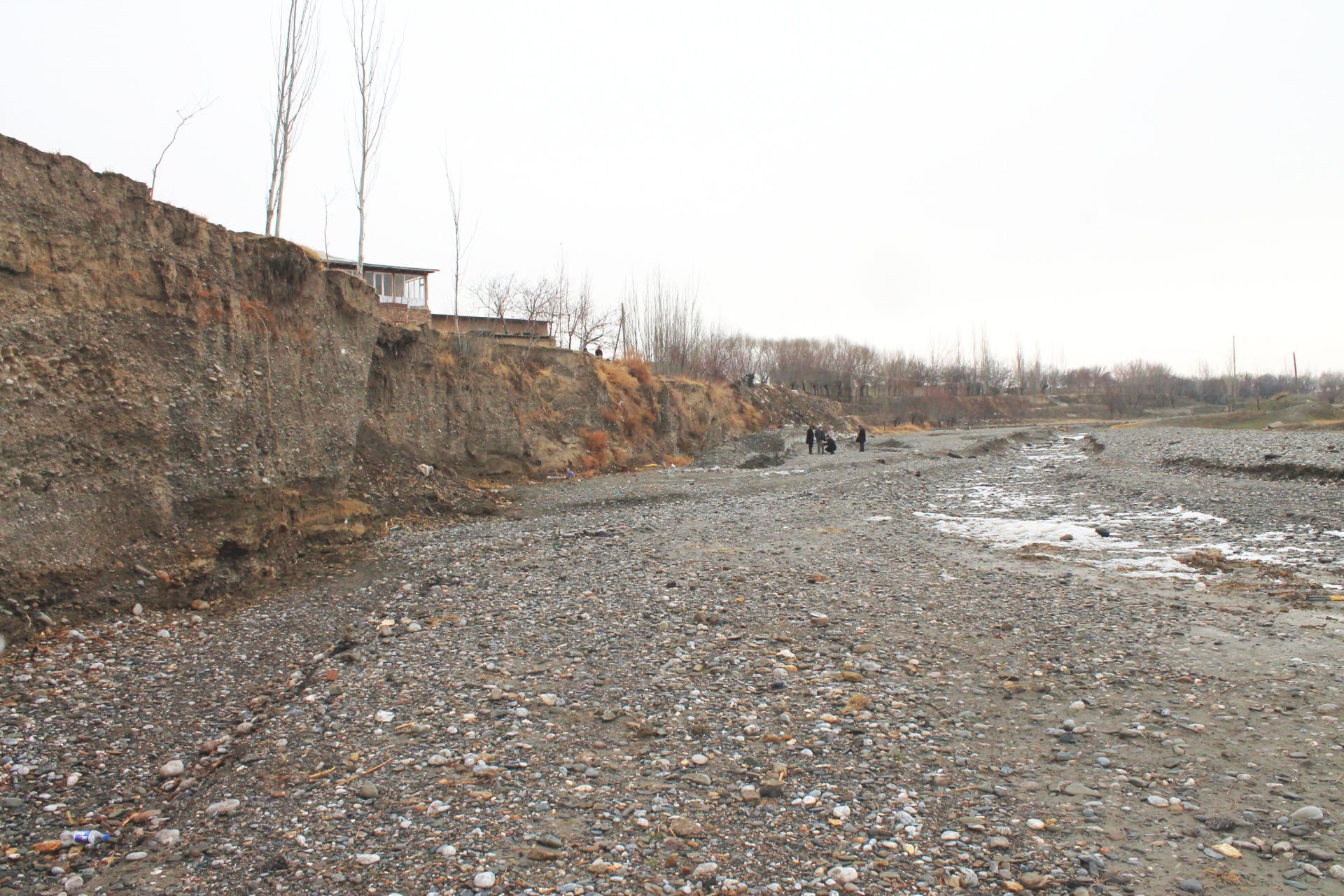
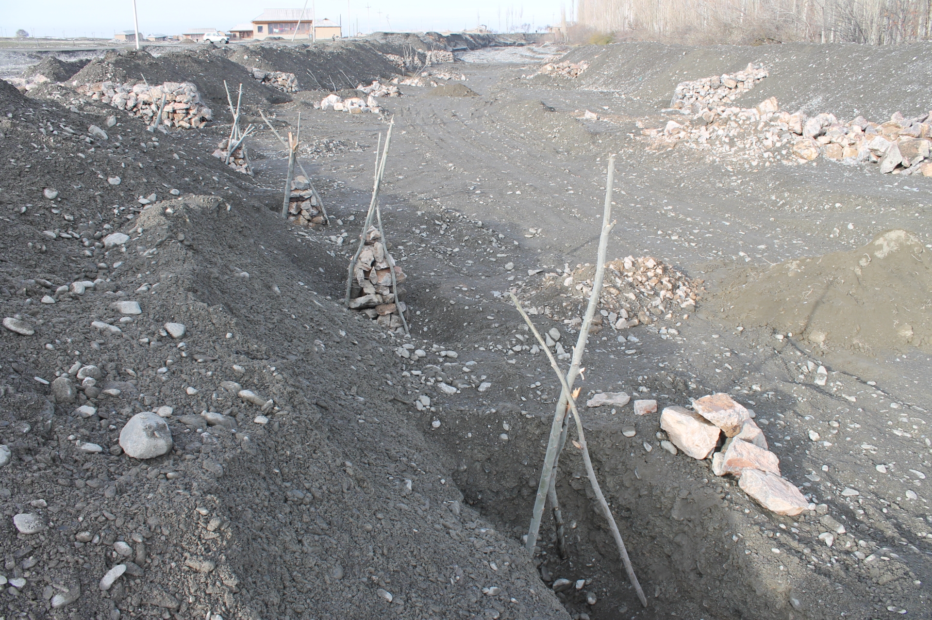
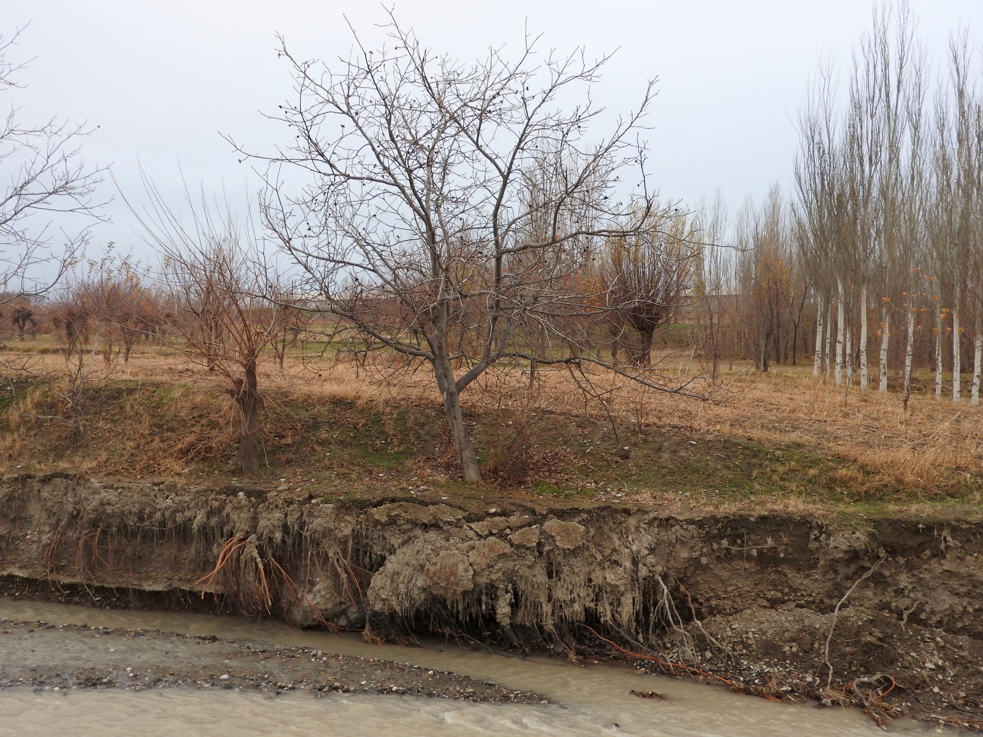
Villages and associated productive lands like orchards, gardens and arable fields in the lower parts of the northern main slope of the Turkestan mountain range are typically located in the valleys of rivers and streams. Water discharge in these rivers and streams is seasonally highly variable. During the wet season water flow is very high, while during the dry summer and fall months almost no water is visible at the surface and the limited discharge takes place in the gravel of the riverbed. After rainfall and during snowmelt extreme flow events happen with discharges several times exceeding the average of the wet season. Flashfloods with high speed and energy typically cause the transportation of large amounts of debris. These debris flows can be much more destructive than ordinary high water events. The resulting riverbank erosion is in some extent a natural element of the morphological dynamic of rivers and streams.
Land-use related factors have increased the vulnerability of communities to these flashfloods and debris flows as well as their destructiveness. Population growth, the expansion of settlements and the reclamation of more lands for irrigated orchards, gardens and arable fields have brought more people and values into potentially risky areas. The degradation of the vegetation in upper catchments has contributed to reduced infiltration of water and high and fast surface runoff. The riparian forests and woodlands which in some extent slow down flashfloods and keep sediment have been largely destroyed by clearing, livestock grazing and by the increasing intensity of flashflood events.
These problems are increasingly exacerbated by the impact of climate change. The already visible trends and predictions show higher levels of aridity, higher temperatures during the vegetation season, reduced overall precipitation in catchment areas – all affecting the retention potential of upper catchment areas – and more irregular rainfall patterns, reduced snow packs and accelerated snow melt as well as the loss of glaciers as buffers of water flow. These factors all contribute to a higher frequency and intensity of flashflood and debris flows.
These events threaten settlements, infrastructure and human lives, but they also pose substantial risks to the stability and functioning of irrigation canals, cause irreversibly losses of productive lands and thus threaten livelihoods of farmers and food security.
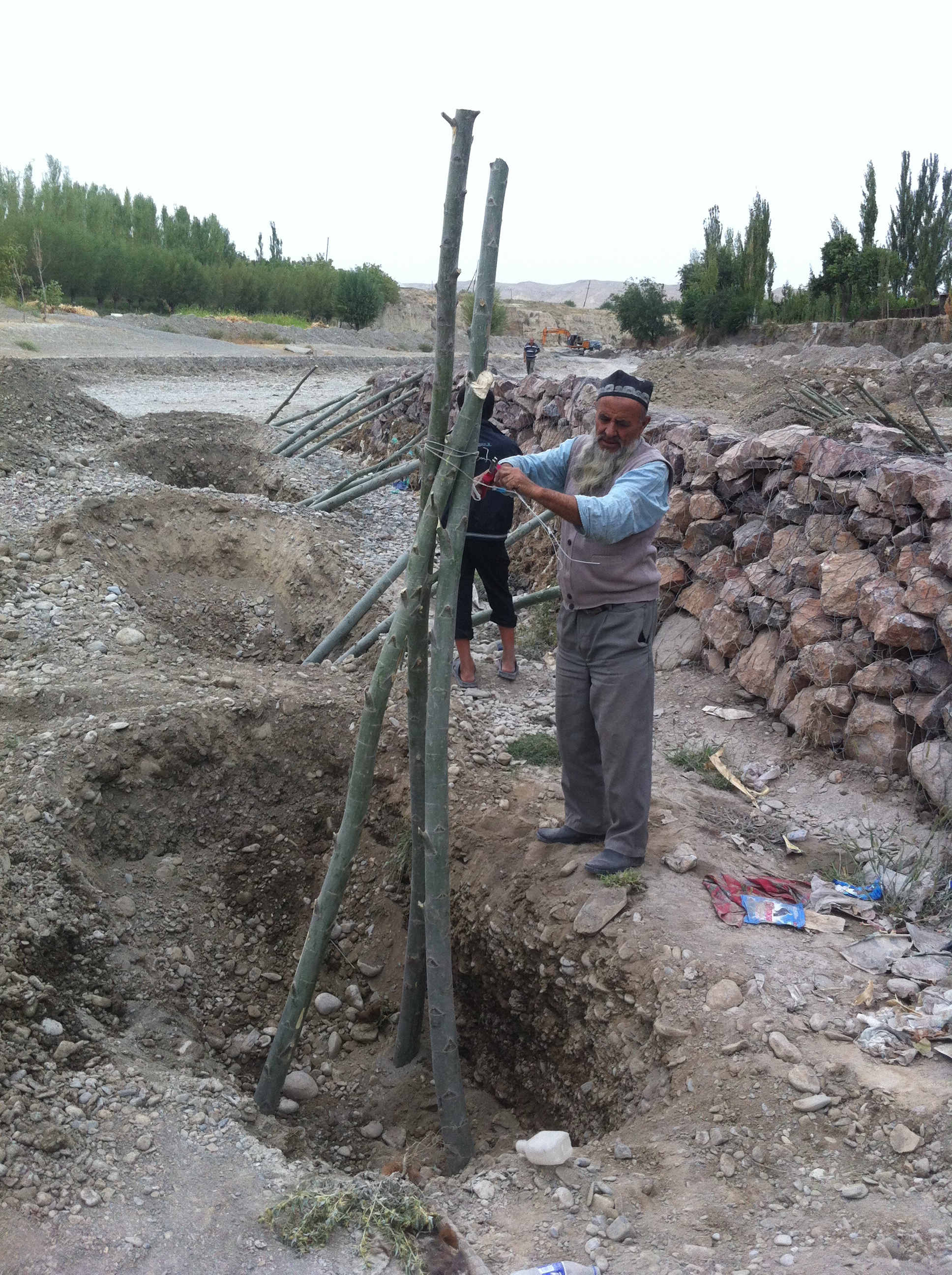
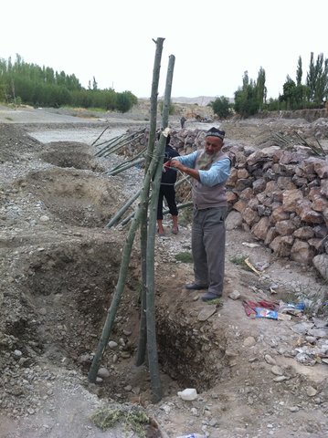
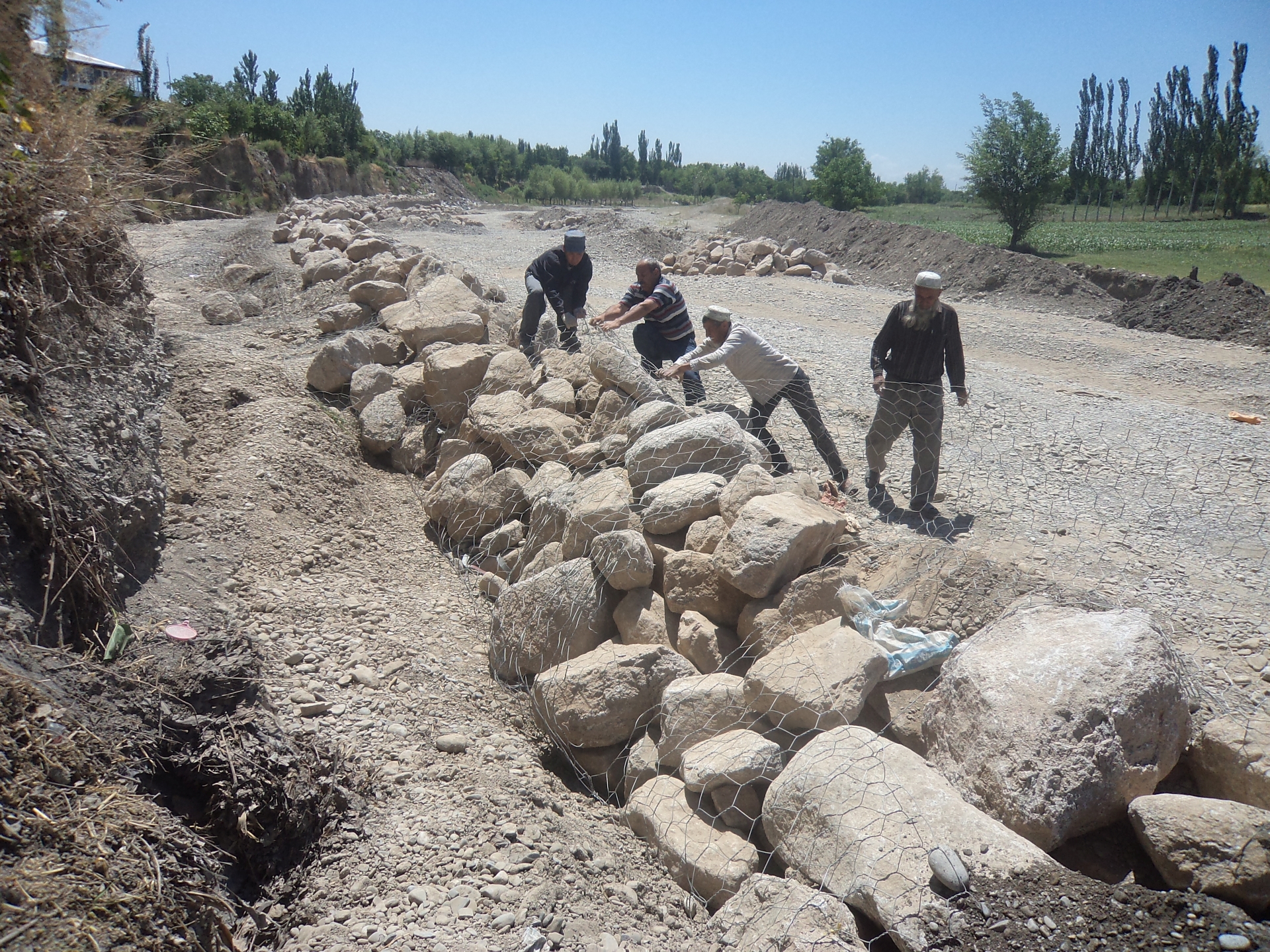
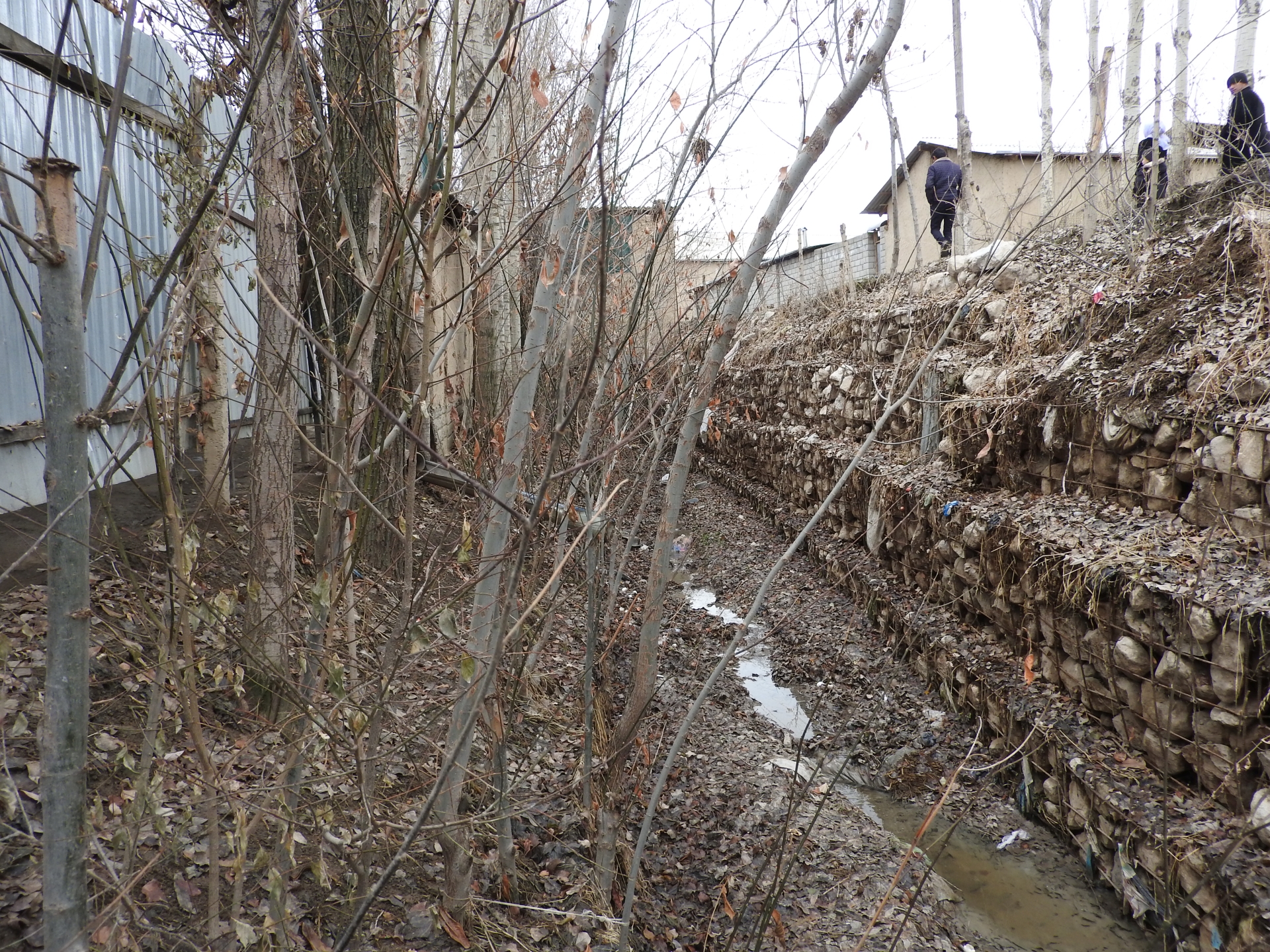
The approach brought together the Committee of Emergency Situations, affected local people and the administrative communities, the mahalla committees, which represent the inhabitants of one village or a section of a larger village. These institutions are called communal self-governance structures, but are subordinated to the government as they are reporting to the sub-district or jamoat. Assisted by experts provided by the project, the situation was jointly analyzed; risks identified and integrated intervention planned. Typically the interventions consisted of a combination of “grey” (i.e. constructive structures) and “green” (i.e. protective vegetation) measures. Most of the upper catchment areas belong to different communities, often to different districts and substantial parts are located in neighboring Kyrgyzstan. Therefore addressing the degradation of these areas and a reduction of disaster risk through integrated watershed management in the entire catchments was rarely possible.
The project assisted with technical planning, construction supervision, purchase and transportation of construction materials. The communities would contribute about 30% of the overall costs, mainly in form of voluntary communal work, the so called hashar, as well as in form of locally available construction materials. The community is also in charge of future operation and maintenance of the riverbank protection structures.
2.3 该方法的照片
媒体库
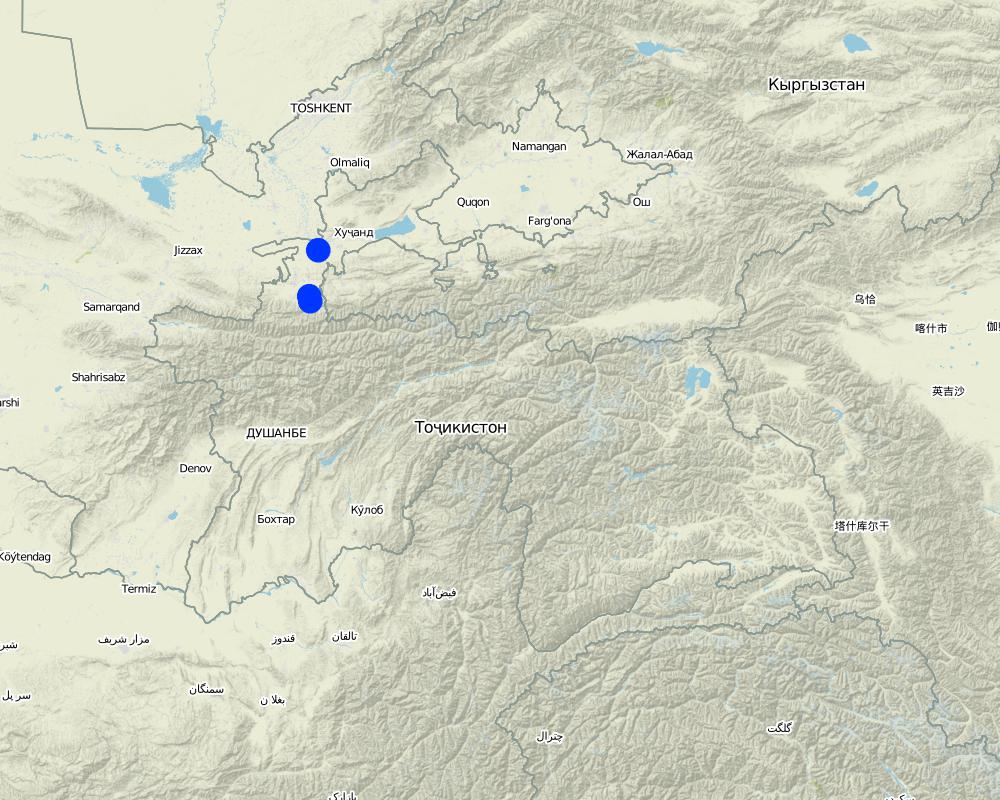
2.5 采用该方法的国家/地区/地点
国家:
塔吉克斯坦
区域/州/省:
Sughd region
有关地点的进一步说明:
Spitamen district, Devashtich district
Map
×2.6 该方法的开始和终止日期
注明开始年份:
2014
若不知道准确的年份,请注明该方法的大致开始日期。:
不到10年前(最近)
2.7 方法的类型
- 基于项目/方案
2.8 该方法的主要目的/目标
Prevention of disasters caused by flashfloods and debris flows
2.9 推动或妨碍实施本办法所适用的技术的条件
财务资源和服务的可用性/可得性
- 阻碍
Communities and Committee of Emergency Situations without external assistance not able to implement effective integrated measures.
机构设置
- 启动
Good collaboration between communities and Committee of Emergency Situations.
参与者的的协作/协调
- 启动
Good collaboration between communities and Committee of Emergency Situations.
了解SLM,获得技术支持
- 阻碍
Insufficient knowledge in communities about effective technololgy.
工作量、人力资源可用性
- 启动
Traditional joint volunteer work in communities for addressing common problems (hashar).
3. 相关利益相关者的参与和角色
3.1 该方法涉及的利益相关者及其职责
- 当地土地使用者/当地社区
Inhabitants of village
Participation in identification of risk sites;
Volunteer work
- SLM专家/农业顾问
Engineers provided by GIZ
Identification of risk sites;
Design, planning and supervision of interventions.
- 地方政府
District branches of Committee for Emergency Situations
Participation in identification of risk sites;
Agreement of plans for interventions
3.2 当地土地使用者/当地社区参与该方法的不同阶段
| 当地土地使用者/当地社区的参与 | 指定参与人员并描述活动 | |
|---|---|---|
| 启动/动机 | 互动 | Participation in identification of risk sites; |
| 计划 | 互动 | Participation in discussion of interventions; |
| 实施 | 互动 | Volunteer work |
| 监测/评估 | 互动 | Control of conditions and functioning of protective structures |
3.4 有关SLM技术选择的决策
具体说明谁有权决定选择要实施的技术:
- 所有相关参与者,作为参与式方法的一部分
4. 技术支持、能力建设和知识管理
4.1 能力建设/培训
是否为土地使用者/其他利益相关者提供培训?:
否
4.2 咨询服务
土地使用者有权使用咨询服务吗?:
是
说明/注释:
Not involved in this approach
4.3 机构强化(组织发展)
是否通过这种方法建立或加强了机构?:
- 是,少许
具体说明机构的强化或建立程度:
- 本地
说明机构、角色和职责、成员等。:
Strengthening of community institutions in addressing issues of common concern.
具体说明支持类型:
- 能力建设/培训
4.4 监测和评估
监测和评估是该方法的一部分吗?:
是
若是,该文件是否用于监测和评估?:
否
4.5 研究
研究是该方法的一部分吗?
否
5. 融资和外部物质支持
5.1 该方法中SLM组成部分的年度预算
如果不知道准确的年度预算,请给出一个范围:
- 10,000-100,000
注释(例如主要的资助来源/主要捐助者):
Government of Germany, implemented via Deutsche Gesellschaft für Internationale Zusammenarbeit (GIZ). The approach has been implemented in the frame of a much larger program and the specific budget for the SLM component of the Approach cannot be determined.
5.2 为土地使用者提供财政/物质支援
土地使用者是否获得实施该技术的财政/物质支持?:
是
如果是,请具体说明支持的类型、条件和提供者:
Costs of planning, design and supervision, costs of materials, transportation and machinery covered by GIZ.
5.3 对特定投入的补贴(包括劳动力)
- 设备
| 具体说明哪些投入得到了补贴 | 程度如何 | 对补贴做出具体说明 |
|---|---|---|
| 机械 | 充分融资 | |
- 建筑
| 具体说明哪些投入得到了补贴 | 程度如何 | 对补贴做出具体说明 |
|---|---|---|
| 石料 | 部分融资 | |
| Gabion nets | 充分融资 | |
如果土地使用者的劳动力是一项重要的投入,那么是不是:
- 自愿
5.4 信用
是否根据SLM活动的方法给予信用值?:
否
5.5 其它激励或手段
是否有其他激励措施或工具用于促进SLM技术的实施?:
否
6. 影响分析和结论性陈述
6.1 方法的影响
该方法是否有助于当地土地使用者,提高利益相关者的参与度?:
- 否
- 是,很少
- 是,中等
- 是,支持力度很大
People mobilized to address common issues.
该方法是否帮助土地使用者实施和维护SLM技术?:
- 否
- 是,很少
- 是,中等
- 是,支持力度很大
Grey and geeen measures for prevention of riverbank erosion
该方法是否提高了SLM的协调性和成本效益?:
- 否
- 是,很少
- 是,中等
- 是,支持力度很大
该方法是否调动/改善了使用财务资源实施SLM的途径?:
- 否
- 是,很少
- 是,中等
- 是,支持力度很大
Combination of financial and technical support by GIZ and contributions in form of work and locally available materials by community members.
该方法是否提高了土地使用者实施土地管理的知识和能力?:
- 否
- 是,很少
- 是,中等
- 是,支持力度很大
Community members capable of replicating the technologies.
该方法是否提高了其他利益相关者的知识和能力?:
- 否
- 是,很少
- 是,中等
- 是,支持力度很大
Committee of Emergency Situations capable of replicating the technologies.
Improved collaboration between Committe of Emergency Situations, communal self-governance and community members.
该方法是否鼓励年轻人/下一代土地使用者参与SLM?:
- 否
- 是,很少
- 是,中等
- 是,支持力度很大
Involvement of young people in joint work
该方法是否改善了粮食安全/改善了营养?:
- 否
- 是,很少
- 是,中等
- 是,支持力度很大
Reduced risk of destruction of irrigation infrastructure and of loss of productive lands.
该方法是否提高了土地使用者适应气候变化/极端情况和减轻气候相关灾害的能力?:
- 否
- 是,很少
- 是,中等
- 是,支持力度很大
Reduced risk of destructive impacts of flashfloods and debris flows, which due to climate change are increasing in frequency and intensity.
6.2 土地使用者实施SLM的主要动机
- 降低灾害风险
6.3 方法活动的可持续性
土地使用者能否维持通过该方法实施的措施(无外部支持的情况下)?:
- 是
6.4 该方法的长处/优点
| 土地使用者眼中的长处/优势/机会 |
|---|
| Reduced disaster risk |
| Availability of wood from green measures |
| 编制者或其他关键资源人员认为的长处/优势/机会 |
|---|
| Same as land-users |
| Improved collaboration at local level and strengthened institutions |
| Ownership feeling among community members |
6.5 该方法的弱点/缺点以及克服它们的方法
| 土地使用者认为的弱点/缺点/风险 | 如何克服它们? |
|---|---|
| None |
| 编制者或其他关键资源人员认为的弱点/缺点/风险 | 如何克服它们? |
|---|---|
| None |
7. 参考和链接
7.1 方法/信息来源
- 实地考察、实地调查
- 与土地使用者的访谈
- 与SLM专业人员/专家的访谈
- 根据报告和其他现有文档进行编译
链接和模块
全部展开 全部收起链接
Prevention of riverbank erosion by combination of green … [塔吉克斯坦]
Flashfloods in riverbeds cause intensive riverbank erosion, which threatens villages, infrastructure and productive lands. Preventive measures combining "grey" (physical structures) and "green" (living trees) elements are more effective, sustainable and cost efficient than constructive measures only.
- 编制者: Stefan Michel
模块
无模块