Integrated disaster risk reduction in flood-affected areas by local communities [Tadjikistan]
- Création :
- Mise à jour :
- Compilateur : Stefan Michel
- Rédacteur : –
- Examinateur : Umed Vahobov
Интегрированный подход к снижению риска стихийных бедствий местными сообществами, в местностях подверженным селевым потокам
approaches_4319 - Tadjikistan
Voir les sections
Développer tout Réduire tout1. Informations générales
1.2 Coordonnées des personnes-ressources et des institutions impliquées dans l'évaluation et la documentation de l'Approche
Personne(s) ressource(s) clé(s)
Spécialiste GDT:
Muhidinov Nodir
nodir.sfl@gmail.com
Deutsche Gesellschaft für Internationale Zusammenarbeit (GIZ)
Tadjikistan
Nom du projet qui a facilité la documentation/ l'évaluation de l'Approche (si pertinent)
Strengthening of Livelihoods through Climate Change Adaptation in Kyrgyzstan and TajikistanNom du ou des institutions qui ont facilité la documentation/ l'évaluation de l'Approche (si pertinent)
Deutsche Gesellschaft für Internationale Zusammenarbeit - Tajikistan (GIZ Tajikistan) - Tadjikistan1.3 Conditions relatives à l'utilisation par WOCAT des données documentées
Le compilateur et la(les) personne(s) ressource(s) acceptent les conditions relatives à l'utilisation par WOCAT des données documentées:
Oui
1.4 Références au(x) questionnaire(s) sur les Technologies de GDT
Prevention of riverbank erosion by combination of green … [Tadjikistan]
Flashfloods in riverbeds cause intensive riverbank erosion, which threatens villages, infrastructure and productive lands. Preventive measures combining "grey" (physical structures) and "green" (living trees) elements are more effective, sustainable and cost efficient than constructive measures only.
- Compilateur : Stefan Michel
2. Description de l'Approche de GDT
2.1 Courte description de l'Approche
Climate change and land degradation in upper catchment areas cause an increasing frequency and intensity of flash flood and debris flows affecting settlements and productive areas. GIZ in collaboration with the Committee on Emergency Situations assisted local communities in the implementation of integrated preventive measures.
2.2 Description détaillée de l'Approche
Description détaillée de l'Approche:
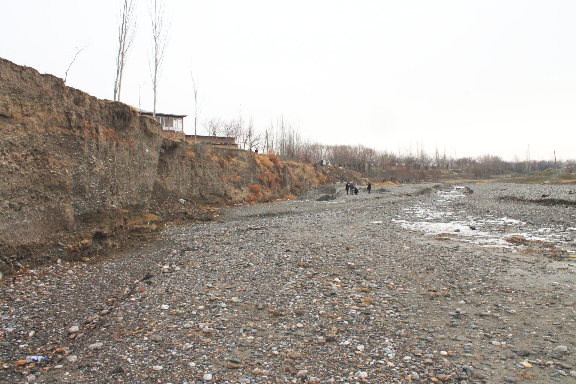
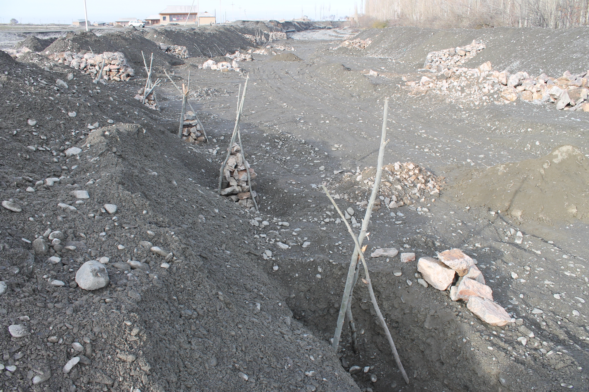
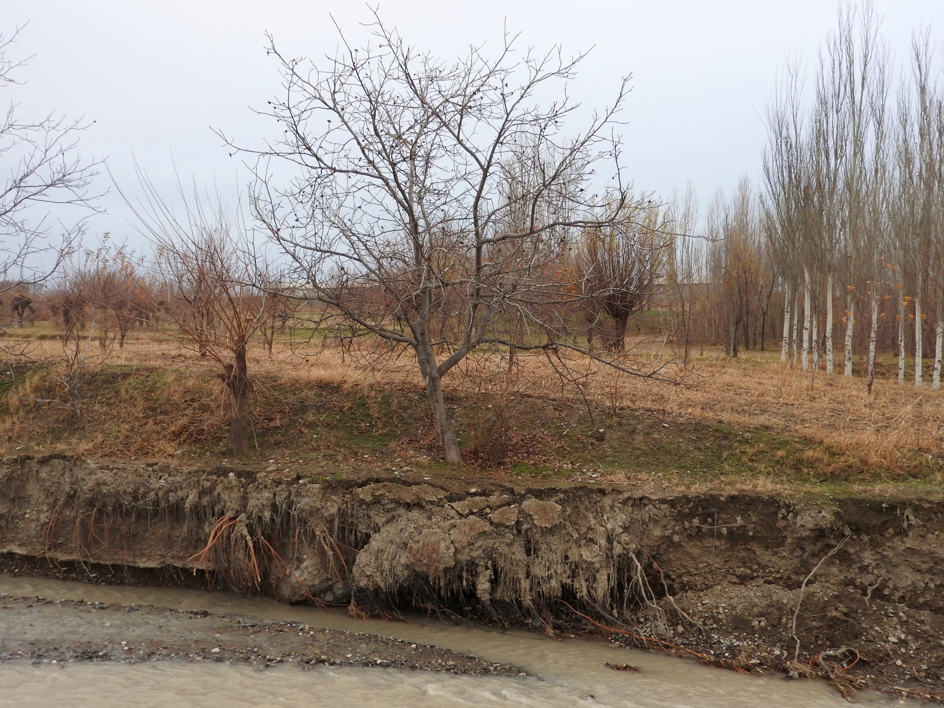
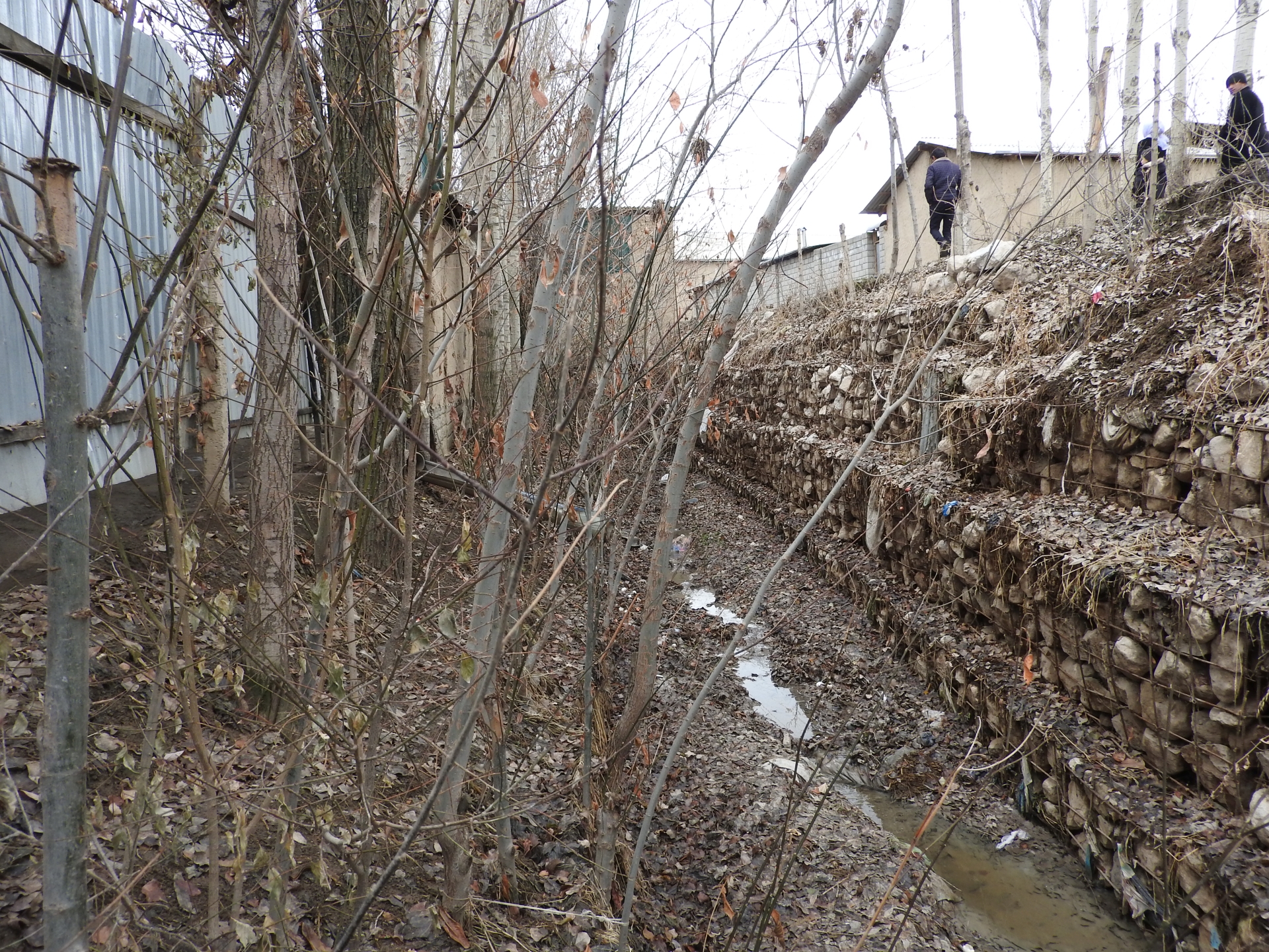
Villages and associated productive lands like orchards, gardens and arable fields in the lower parts of the northern main slope of the Turkestan mountain range are typically located in the valleys of rivers and streams. Water discharge in these rivers and streams is seasonally highly variable. During the wet season water flow is very high, while during the dry summer and fall months almost no water is visible at the surface and the limited discharge takes place in the gravel of the riverbed. After rainfall and during snowmelt extreme flow events happen with discharges several times exceeding the average of the wet season. Flashfloods with high speed and energy typically cause the transportation of large amounts of debris. These debris flows can be much more destructive than ordinary high water events. The resulting riverbank erosion is in some extent a natural element of the morphological dynamic of rivers and streams.
Land-use related factors have increased the vulnerability of communities to these flashfloods and debris flows as well as their destructiveness. Population growth, the expansion of settlements and the reclamation of more lands for irrigated orchards, gardens and arable fields have brought more people and values into potentially risky areas. The degradation of the vegetation in upper catchments has contributed to reduced infiltration of water and high and fast surface runoff. The riparian forests and woodlands which in some extent slow down flashfloods and keep sediment have been largely destroyed by clearing, livestock grazing and by the increasing intensity of flashflood events.
These problems are increasingly exacerbated by the impact of climate change. The already visible trends and predictions show higher levels of aridity, higher temperatures during the vegetation season, reduced overall precipitation in catchment areas – all affecting the retention potential of upper catchment areas – and more irregular rainfall patterns, reduced snow packs and accelerated snow melt as well as the loss of glaciers as buffers of water flow. These factors all contribute to a higher frequency and intensity of flashflood and debris flows.
These events threaten settlements, infrastructure and human lives, but they also pose substantial risks to the stability and functioning of irrigation canals, cause irreversibly losses of productive lands and thus threaten livelihoods of farmers and food security.
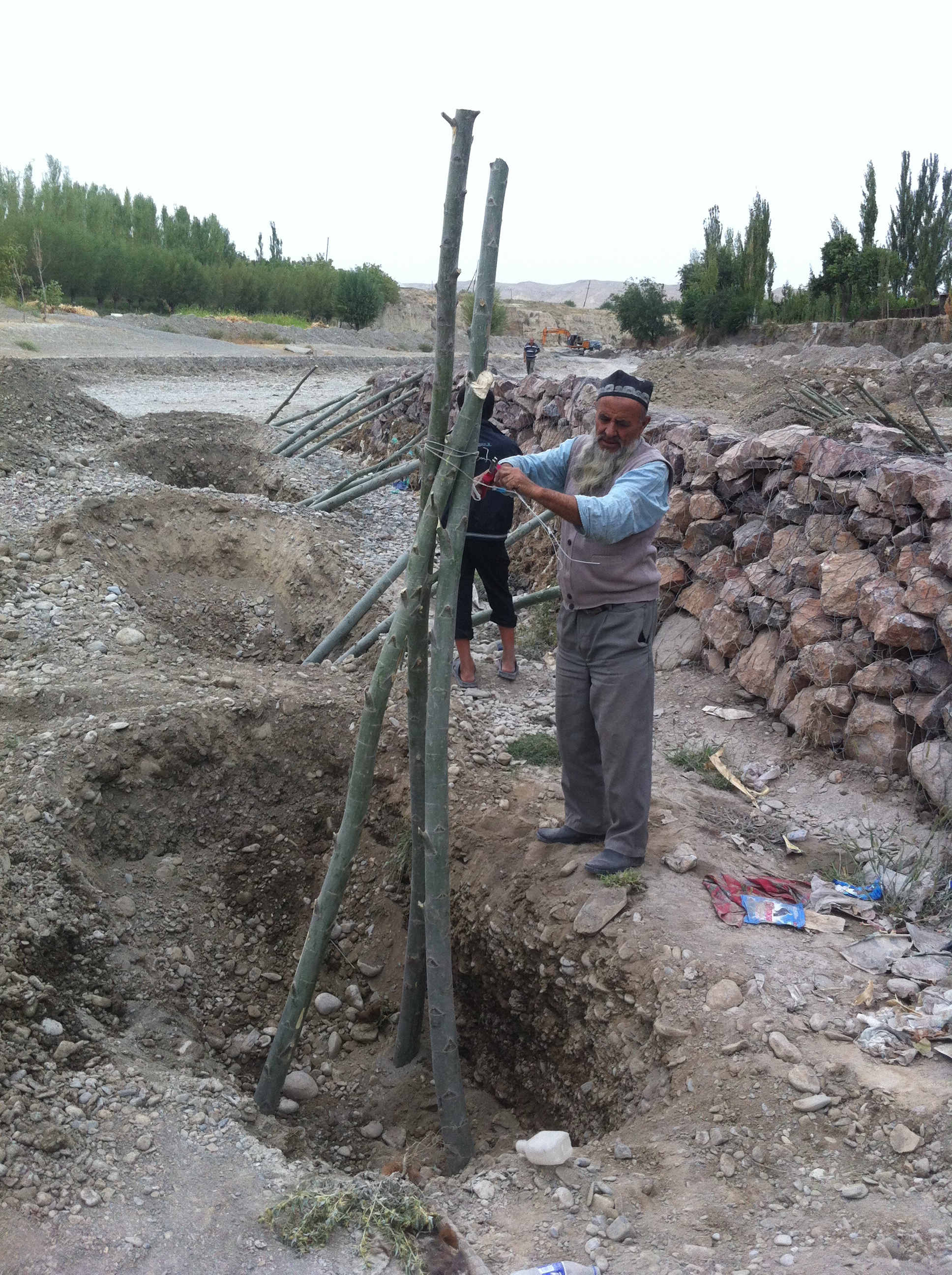
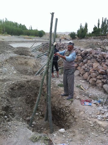
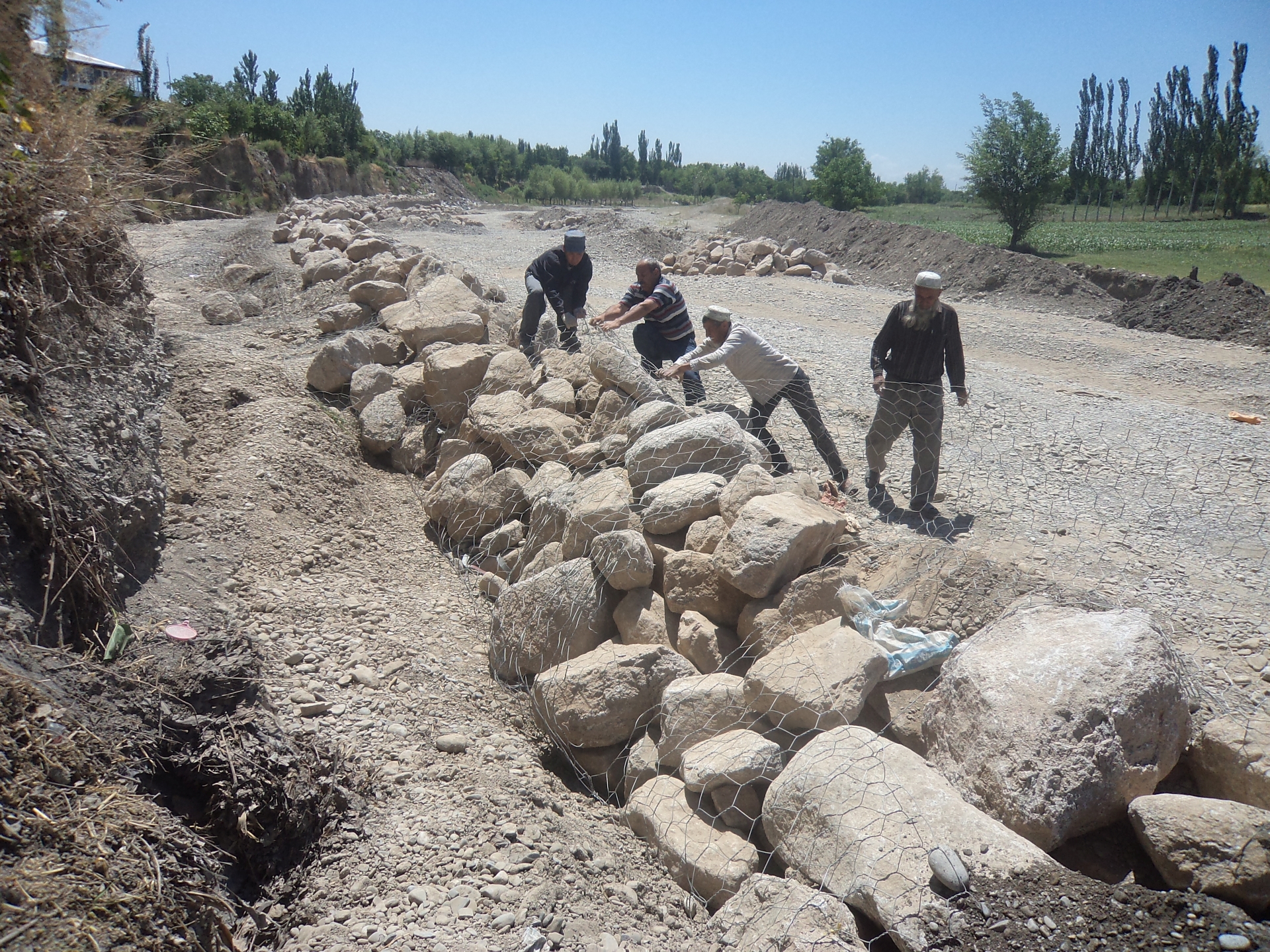
The approach brought together the Committee of Emergency Situations, affected local people and the administrative communities, the mahalla committees, which represent the inhabitants of one village or a section of a larger village. These institutions are called communal self-governance structures, but are subordinated to the government as they are reporting to the sub-district or jamoat. Assisted by experts provided by the project, the situation was jointly analyzed; risks identified and integrated intervention planned. Typically the interventions consisted of a combination of “grey” (i.e. constructive structures) and “green” (i.e. protective vegetation) measures. Most of the upper catchment areas belong to different communities, often to different districts and substantial parts are located in neighboring Kyrgyzstan. Therefore addressing the degradation of these areas and a reduction of disaster risk through integrated watershed management in the entire catchments was rarely possible.
The project assisted with technical planning, construction supervision, purchase and transportation of construction materials. The communities would contribute about 30% of the overall costs, mainly in form of voluntary communal work, the so called hashar, as well as in form of locally available construction materials. The community is also in charge of future operation and maintenance of the riverbank protection structures.
2.3 Photos de l'approche
Galerie Médias
2.5 Pays/ région/ lieux où l'Approche a été appliquée
Pays:
Tadjikistan
Région/ Etat/ Province:
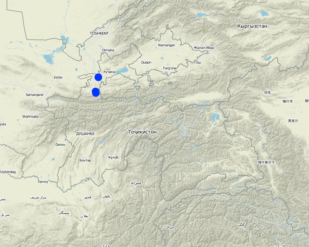
Sughd region
Autres spécifications du lieu :
Spitamen district, Devashtich district
Map
×2.6 Dates de début et de fin de l'Approche
Indiquez l'année de démarrage:
2014
Si l'année précise est inconnue, indiquez approximativement quand l'Approche a démarré:
il y a moins de 10 ans (récemment)
2.7 Type d'Approche
- fondé sur un projet/ programme
2.8 Principaux objectifs de l'Approche
Prevention of disasters caused by flashfloods and debris flows
2.9 Conditions favorisant ou entravant la mise en œuvre de la(des) Technologie(s) appliquée(s) sous l'Approche
disponibilité/ accès aux ressources et services financiers
- entrave
Communities and Committee of Emergency Situations without external assistance not able to implement effective integrated measures.
cadre institutionnel
- favorise
Good collaboration between communities and Committee of Emergency Situations.
collaboration/ coordination des acteurs
- favorise
Good collaboration between communities and Committee of Emergency Situations.
connaissances sur la GDT, accès aux supports techniques
- entrave
Insufficient knowledge in communities about effective technololgy.
charge de travail, disponibilité de la main-d'œuvre
- favorise
Traditional joint volunteer work in communities for addressing common problems (hashar).
3. Participation et rôles des parties prenantes impliquées dans l'Approche
3.1 Parties prenantes impliquées dans l'Approche et rôles
- exploitants locaux des terres / communautés locales
Inhabitants of village
Participation in identification of risk sites;
Volunteer work
- Spécialistes de la GDT/ conseillers agricoles
Engineers provided by GIZ
Identification of risk sites;
Design, planning and supervision of interventions.
- gouvernement local
District branches of Committee for Emergency Situations
Participation in identification of risk sites;
Agreement of plans for interventions
3.2 Participation des exploitants locaux des terres/ communautés locales aux différentes phases de l'Approche
| Participation des exploitants locaux des terres/ communautés locales | Spécifiez qui était impliqué et décrivez les activités | |
|---|---|---|
| initiation/ motivation | interactive | Participation in identification of risk sites; |
| planification | interactive | Participation in discussion of interventions; |
| mise en œuvre | interactive | Volunteer work |
| suivi/ évaluation | interactive | Control of conditions and functioning of protective structures |
3.4 Prises de décision pour la sélection de la Technologie/ des Technologies
Indiquez qui a décidé de la sélection de la Technologie/ des Technologies à mettre en œuvre:
- tous les acteurs concernés dans le cadre d'une approche participative
4. Soutien technique, renforcement des capacités et gestion des connaissances
4.1 Renforcement des capacités/ formation
Une formation a-t-elle été dispensée aux exploitants des terres/ autres parties prenantes?
Non
4.2 Service de conseils
Les exploitants des terres ont-ils accès à un service de conseils?
Oui
Décrivez/ commentez:
Not involved in this approach
4.3 Renforcement des institutions (développement organisationnel)
Des institutions ont elles été mises en place ou renforcées par le biais de l'Approche?
- oui, un peu
Spécifiez à quel(s) niveau(x), ces institutions ont été renforcées ou mises en place:
- local
Décrivez l'institution, ses rôles et responsabilités, ses membres, etc.
Strengthening of community institutions in addressing issues of common concern.
Précisez le type de soutien:
- renforcement des capacités/ formation
4.4 Suivi et évaluation
Le suivi et l'évaluation font ils partie de l'Approche? :
Oui
Si oui, ce document est-il destiné à être utilisé pour le suivi et l'évaluation?
Non
4.5 Recherche
La recherche a-t-elle fait partie intégrante de l’Approche?
Non
5. Financement et soutien matériel externe
5.1 Budget annuel de la composante GDT de l'Approche
Si le budget annuel précis n'est pas connu, indiquez une fourchette:
- 10 000-100 000
Commentez (par ex. principales sources de financement/ principaux bailleurs de fonds):
Government of Germany, implemented via Deutsche Gesellschaft für Internationale Zusammenarbeit (GIZ). The approach has been implemented in the frame of a much larger program and the specific budget for the SLM component of the Approach cannot be determined.
5.2 Soutiens financiers/ matériels fournis aux exploitants des terres
Les exploitants des terres ont-ils reçu un soutien financier/ matériel pour la mise en œuvre de la Technologie/ des Technologies?
Oui
Si oui, spécifiez le(s) type(s) de soutien, les conditions et les fournisseurs:
Costs of planning, design and supervision, costs of materials, transportation and machinery covered by GIZ.
5.3 Subventions pour des intrants spécifiques (incluant la main d'œuvre)
- équipement
| Spécifiez les intrants subventionnés | Dans quelle mesure | Spécifiez les subventions |
|---|---|---|
| machines | entièrement financé | |
- matériaux de construction
| Spécifiez les intrants subventionnés | Dans quelle mesure | Spécifiez les subventions |
|---|---|---|
| pierres | en partie financé | |
| Gabion nets | entièrement financé | |
Si la main d'œuvre fournie par les exploitants des terres était un intrant substantiel, elle était:
- volontaire
5.4 Crédits
Des crédits ont-ils été alloués à travers l'Approche pour les activités de GDT?
Non
5.5 Autres incitations ou instruments
D'autres incitations ou instruments ont-ils été utilisés pour promouvoir la mise en œuvre des Technologies de GDT?
Non
6. Analyses d'impact et conclusions
6.1 Impacts de l'Approche
Est-ce que l'Approche a autonomisé les exploitants locaux des terres, amélioré la participation des parties prenantes?
- Non
- Oui, un peu
- Oui, modérément
- Oui, beaucoup
People mobilized to address common issues.
Est-ce que l'Approche a aidé les exploitants des terres à mettre en œuvre et entretenir les Technologies de GDT?
- Non
- Oui, un peu
- Oui, modérément
- Oui, beaucoup
Grey and geeen measures for prevention of riverbank erosion
Est-ce que l'Approche a amélioré la coordination et la mise en œuvre de la GDT selon un bon rapport coût-efficacité?
- Non
- Oui, un peu
- Oui, modérément
- Oui, beaucoup
Est-ce que l'Approche a mobilisé/ amélioré l'accès aux ressources financières pour la mise en œuvre de la GDT?
- Non
- Oui, un peu
- Oui, modérément
- Oui, beaucoup
Combination of financial and technical support by GIZ and contributions in form of work and locally available materials by community members.
Est-ce que l'Approche a amélioré les connaissances et les capacités des exploitants des terres pour mettre en œuvre la GDT?
- Non
- Oui, un peu
- Oui, modérément
- Oui, beaucoup
Community members capable of replicating the technologies.
Est-ce que l'Approche a amélioré les connaissances et les capacités des autres parties prenantes?
- Non
- Oui, un peu
- Oui, modérément
- Oui, beaucoup
Committee of Emergency Situations capable of replicating the technologies.
Improved collaboration between Committe of Emergency Situations, communal self-governance and community members.
Est-ce que l'Approche a encouragé les jeunes/ la prochaine génération d'exploitants des terres à s'engager dans la GDT?
- Non
- Oui, un peu
- Oui, modérément
- Oui, beaucoup
Involvement of young people in joint work
Est-ce que l'Approche a conduit à améliorer la sécurité alimentaire et/ou la nutrition?
- Non
- Oui, un peu
- Oui, modérément
- Oui, beaucoup
Reduced risk of destruction of irrigation infrastructure and of loss of productive lands.
Est-ce que l'Approche a amélioré la capacité des exploitants des terres à s'adapter aux changements/ extrêmes climatiques et a atténué les catastrophes liées au climat?
- Non
- Oui, un peu
- Oui, modérément
- Oui, beaucoup
Reduced risk of destructive impacts of flashfloods and debris flows, which due to climate change are increasing in frequency and intensity.
6.2 Principale motivation des exploitants des terres pour mettre en œuvre la GDT
- réduire les risques de catastrophe
6.3 Durabilité des activités de l'Approche
Les exploitants des terres peuvent-ils poursuivre ce qui a été mis en œuvre par le biais de l'Approche (sans soutien extérieur)?
- oui
6.4 Points forts/ avantages de l'Approche
| Points forts/ avantages/ possibilités du point de vue de l'exploitant des terres |
|---|
| Reduced disaster risk |
| Availability of wood from green measures |
| Points forts/ avantages/ possibilités du point de vue du compilateur ou d'une autre personne ressource clé |
|---|
| Same as land-users |
| Improved collaboration at local level and strengthened institutions |
| Ownership feeling among community members |
6.5 Faiblesses/ inconvénients de l'Approche et moyens de les surmonter
| Faiblesses/ inconvénients/ risques du point de vue de l’exploitant des terres | Comment peuvent-ils être surmontés? |
|---|---|
| None |
| Faiblesses/ inconvénients/ risques du point de vue du compilateur ou d'une autre personne ressource clé | Comment peuvent-ils être surmontés? |
|---|---|
| None |
7. Références et liens
7.1 Méthodes/ sources d'information
- visites de terrain, enquêtes sur le terrain
- interviews/entretiens avec les exploitants des terres
- interviews/ entretiens avec les spécialistes/ experts de GDT
- compilation à partir de rapports et d'autres documents existants
Liens et modules
Développer tout Réduire toutLiens
Prevention of riverbank erosion by combination of green … [Tadjikistan]
Flashfloods in riverbeds cause intensive riverbank erosion, which threatens villages, infrastructure and productive lands. Preventive measures combining "grey" (physical structures) and "green" (living trees) elements are more effective, sustainable and cost efficient than constructive measures only.
- Compilateur : Stefan Michel
Modules
Aucun module trouvé