Shelterbelts for farmland in sandy areas
(จีน)
Farmland shelter belt
คำอธิบาย
Belts of trees, planted in a rectangular grid pattern or in strips within, and on the periphery of, farmland to act as windbreaks.
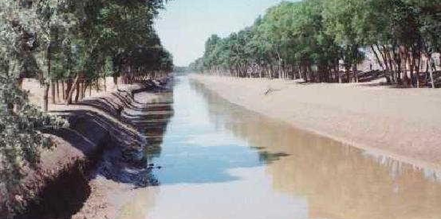
Shelterbelts to protect cropland are a specific type of agroforestry system comprising certain tall growing tree species. Such shelterbelts around farmland help reduce natural hazards including sandstorms, wind erosion, shifting sand, droughts and frost. They also improve the microclimate (reduced temperature, wind speed, soil water loss and excessive wind-induced transpiration) and create more favourable conditions for crop production. Thus the establishment of shelterbelts plays a crucial role in the sandy drylands that are affected by wind and resultant desertification
especially during winter and spring. Where there is irrigation, the shelterbelts protect the infrastructure from silting-up with wind-borne sediment.
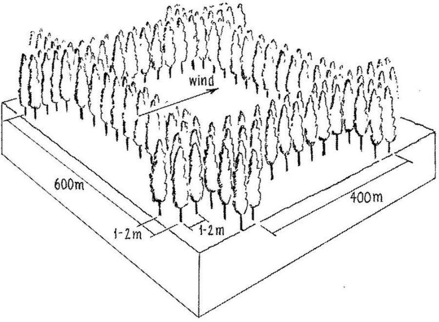
Strips of tall growing species (15-25 m) of poplar (Populus spp.) or willow (Salix spp.) were originally (from 1960s onwards) planted in a 400 by 600 m rectangular grid pattern within extensive areas of cropland, with an extra belt of windbreaks on the windward side (against the prevailing wind). Generally, the distance effectively protected is 15-25 times the tree height. Strips are of variable width, consisting of 2-5 tree lines (1-3 m apart) with trees planted every 1-2 m within the lines. Selective felling is used to maintain adequate growing space and the protective effect of the trees.
The impact of the shelterbelts depends on the planting pattern of the trees (the format of strips and grids), the orientation of the shelterbelts in relation to the wind, the spacing between, and the width of each strip and the type of trees planted. The specific design is primarily based on preventing the negative effects of wind, but depends also on local conditions such as the layout of the land, the location of the roads, farm boundaries and irrigation canals. Ideally the tree strips are perpendicular to the prevailing wind direction, and the angle between the strip and the prevailing wind is never less than 45 degrees. The structure of the strips determines the way the wind is controlled, ranging from blocking the wind
to letting it diffuse through semi-permeable shelterbelts. The best effect is achieved if the wind is not blocked entirely, as this can cause turbulence.
The ownership of the land and the shelterbelts still rests with the state, but management has been more and more transferred to individual households. On condition that the impact of the shelterbelt is not affected, the local forestry agencies now allow some felling of mature trees - on a rotational and selective basis, for timber and firewood. Pine trees (Pinus sylvestris var. mongolica and P. tabulaeformis), which command high value as timber for construction, and fruit (and cash) trees like the apricot tree (Prunus armeniace) are increasingly used.
สถานที่
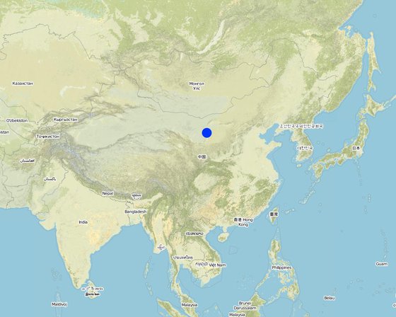
สถานที่: Inner Mongolia Autonomous Region, จีน
ตำนวนการวิเคราะห์เทคโนโลยี:
ตำแหน่งทางภูมิศาสตร์ของสถานที่ที่ถูกเลือ
การเผยแพร่ของเทคโนโลยี: กระจายไปอย่างสม่ำเสมอในพื้นที่ (500.0 km²)
In a permanently protected area?:
วันที่ในการดำเนินการ: มากกว่า 50 ปี (แบบดั้งเดิม)
ประเภทของการแนะนำ
-
ด้วยการริเริ่มของผู้ใช้ที่ดินเอง
-
เป็นส่วนหนึ่งของระบบแบบดั้งเดิมที่ทำก้นอยู่ (> 50 ปี)
-
ในช่วงการทดลองหรือการทำวิจัย
-
ทางโครงการหรือจากภายนอก
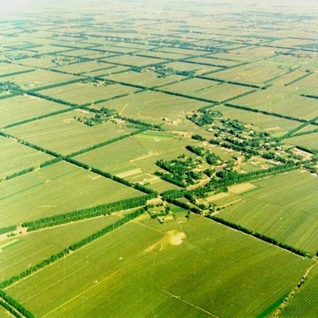
Bird’s-eye view of the rectangular grid of shelterbelts established over wide expanses of cropland to reduce natural hazards and protect crops. (Lingqin Meng)
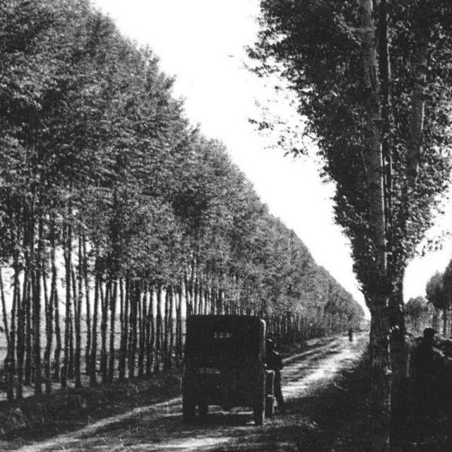
Detailed view of a shelterbelt established in the early 1960s. A road and an irrigation channel run between the tree rows. (anonymous)
จุดประสงค์หลัก
-
ปรับปรุงการผลิตให้ดีขึ้น
-
ลด ป้องกัน ฟื้นฟู การเสื่อมโทรมของที่ดิน
-
อนุรักษ์ระบบนิเวศน์
-
ป้องกันพื้นที่ลุ่มน้ำ/บริเวณท้ายน้ำ โดยร่วมกับเทคโนโลยีอื่นๆ
-
รักษาสภาพหรือปรับปรุงความหลากหลายทางชีวภาพ
-
ลดความเสี่ยงของภัยพิบัติ
-
ปรับตัวเข้ากับการเปลี่ยนแปลงภูมิอากาศของโลก สภาพภูมิอากาศที่รุนแรงและผลกระทบ
-
ชะลอการเปลี่ยนแปลงภูมิอากาศของโลกและผลกระทบ
-
สร้างผลกระทบทางด้านเศรษฐกิจที่เป็นประโยชน์
-
สร้างผลกระทบทางด้านสังคมที่เป็นประโยชน์
การใช้ที่ดิน
Land use mixed within the same land unit: ใช่ - วนเกษตร (Agroforestry)
-
พื้นที่ปลูกพืช
- การปลูกพืชล้มลุกอายุปีเดียว: cereals - maize, wheat
จำนวนของฤดูเพาะปลูกต่อปี: 1
-
ป่า/พื้นที่ทำไม้
- ป่ากึ่งธรรมชาติ / พื้นที่ทำไม้. Management: การตัดไม้ที่มีคัดเลือก (Selective felling)
- ป่า/พื้นที่ทำไม้
Tree types: Pinus species, Populus species, Salix spp
ผลิตภัณฑ์และบริการ: ไม้ซุง, ไม้ที่นำมาทำเป็นเชื้อเพลิง, ผลไม้และถั่ว, การป้องกันภัยธรรมชาติ
การใช้น้ำ
-
จากน้ำฝน
-
น้ำฝนร่วมกับการชลประทาน
-
การชลประทานแบบเต็มรูปแบบ
ความมุ่งหมายที่เกี่ยวข้องกับการเสื่อมโทรมของที่ดิน
-
ป้องกันความเสื่อมโทรมของที่ดิน
-
ลดความเสื่อมโทรมของดิน
-
ฟื้นฟูบำบัดที่ดินที่เสื่อมโทรมลงอย่างมาก
-
ปรับตัวกับสภาพความเสื่อมโทรมของที่ดิน
-
ไม่สามารถใช้ได้
ที่อยู่ของการเสื่อมโทรม
-
การกัดกร่อนของดินโดยลม - Et (Loss of topsoil): การสูญเสียดินชั้นบน, Eo (Offsite degradation effect): ผลกระทบนอกพื้นที่
-
การเสื่อมโทรมของน้ำ - Ha (Aridification): การเกิดความแห้งแล้ง
กลุ่ม SLM
-
การปลูกป่าร่วมกับพืช
-
แนวกันลมหรือแนวต้านลม
มาตรการ SLM
-
มาตรการอนุรักษ์ด้วยวิธีพืช - V1: ต้นไม้และพุ่มไม้คลุมดิน
-
มาตรการอนุรักษ์ด้วยการจัดการ - M1: การเปลี่ยนรูปแบบของการใช้ประโยชน์ที่ดิน
แบบแปลนทางเทคนิค
ข้อมูลจำเพาะด้านเทคนิค
Overview of the shelterbelt layout.
Insert 1: Planting scheme: shelterbelts compromise 2-5 tree lines forming the windbreak about 5-15 m wide and 15-25 m high.
Insert 2: Rectangle grid layout of shelterbelts. Spacing of the rows is denser against the prevailing wind.
Technical knowledge required for field staff / advisors: moderate
Technical knowledge required for land users: low
Main technical functions: increase / maintain water stored in soil, reduction in wind speed, protection from wind erosion, protection from sand encroachment, protection of crops from mechanical damage, reduction in evaporation loss
Secondary technical functions: increase in organic matter
Aligned: -against wind
Vegetative material: T : trees / shrubs
Trees/ shrubs species: Poplars (Populus spp.), willows (Salix spp.), increasingly also pine (Pinus sylvestris var. Mongolic)
Author: Mats Gurtner
การจัดตั้งและการบำรุงรักษา: กิจกรรม ปัจจัยและค่าใช้จ่าย
การคำนวนต้นทุนและค่าใช้จ่าย
- ค่าใช้จ่ายถูกคำนวน ต่อพื้นที่ที่ใช้เทคโนโลยี (หน่วยของขนาดและพื้นที่: ha)
- สกุลเงินที่ใช้คำนวณค่าใช้จ่าย USD
- อัตราแลกเปลี่ยน (ไปเป็นดอลลาร์สหรัฐ) คือ 1 ดอลลาร์สหรัฐ = ไม่มีคำตอบ
- ค่าจ้างเฉลี่ยในการจ้างแรงงานต่อวันคือ 1.20
ปัจจัยที่สำคัญที่สุดที่มีผลต่อค่าใช้จ่าย
The most important factors to affect the costs are seedlings (No.) and machine.
กิจกรรมเพื่อการจัดตั้ง
-
1 Planning / designing of shelterbelt. (ช่วงระยะเวลา/ความถี่: None)
-
2 Selection and collection of trees seedlings. (ช่วงระยะเวลา/ความถี่: None)
-
3 Clearing and preparing land for planting of shelterbelt in (ช่วงระยะเวลา/ความถี่: late autumn and spring)
-
3 Clearing and preparing land for planting of shelterbelt in (ช่วงระยะเวลา/ความถี่: None)
-
4 Pits for planting the seedlings are dug (ช่วงระยะเวลา/ความถี่: 4 Pits for planting the seedlings are dug)
-
5 Tree seedlings are planted (ช่วงระยะเวลา/ความถี่: late spring)
-
6 After planting each seedling is watered for up to two years. (ช่วงระยะเวลา/ความถี่: None)
ปัจจัยและค่าใช้จ่ายของการจัดตั้ง (per ha)
| ปัจจัยนำเข้า |
หน่วย |
ปริมาณ |
ค่าใช้จ่ายต่อหน่วย (USD) |
ค่าใช้จ่ายทั้งหมดต่อปัจจัยนำเข้า (USD) |
%ของค่าใช้จ่ายที่ก่อให้เกิดขึ้นโดยผู้ใช้ที่ดิน |
|
แรงงาน
|
| Mainly collection and planting |
ha |
79.0 |
1.2 |
94.8 |
|
|
อุปกรณ์
|
| tools |
ha |
1.0 |
5.0 |
5.0 |
100.0 |
|
วัสดุด้านพืช
|
| tree seedlings |
ha |
1.0 |
25.0 |
25.0 |
|
| ค่าใช้จ่ายทั้งหมดของการจัดตั้งเทคโนโลยี |
124.8 |
|
| Total costs for establishment of the Technology in USD |
124.8 |
|
กิจกรรมสำหรับการบำรุงรักษา
-
Watering (ช่วงระยะเวลา/ความถี่: after planting /timely)
-
Pruning of trees. (ช่วงระยะเวลา/ความถี่: None)
-
Pest and disease control within shelterbelt. (ช่วงระยะเวลา/ความถี่: None)
-
Intermediate/ selective tree felling. (ช่วงระยะเวลา/ความถี่: None)
ปัจจัยและค่าใช้จ่ายของการบำรุงรักษา (per ha)
| ปัจจัยนำเข้า |
หน่วย |
ปริมาณ |
ค่าใช้จ่ายต่อหน่วย (USD) |
ค่าใช้จ่ายทั้งหมดต่อปัจจัยนำเข้า (USD) |
%ของค่าใช้จ่ายที่ก่อให้เกิดขึ้นโดยผู้ใช้ที่ดิน |
|
แรงงาน
|
| Watering and Pruning |
ha |
7.0 |
1.2 |
8.4 |
100.0 |
|
วัสดุด้านพืช
|
| tree seedling |
ha |
1.0 |
3.0 |
3.0 |
100.0 |
| ค่าใช้จ่ายทั้งหมดของการบำรุงรักษาสภาพเทคโนโลยี |
11.4 |
|
| Total costs for maintenance of the Technology in USD |
11.4 |
|
สิ่งแวดล้อมทางธรรมชาติ
ปริมาณน้ำฝนเฉลี่ยรายปี
-
< 250 ม.ม.
-
251-500 ม.ม.
-
501-750 ม.ม.
-
751-1,000 ม.ม.
-
1,001-1,500 ม.ม.
-
1,501-2,000 ม.ม.
-
2,001-3,000 ม.ม.
-
3,001-4,000 ม.ม.
-
> 4,000 ม.ม.
เขตภูมิอากาศเกษตร
-
ชื้น
-
กึ่งชุ่มชื้น
-
กึ่งแห้งแล้ง
-
แห้งแล้ง
ข้อมูลจำเพาะเรื่องภูมิอากาศ
ปริมาณเฉลี่ยฝนรายปีในหน่วยมม. 430.0
ความชัน
-
ราบเรียบ (0-2%)
-
ลาดที่ไม่ชัน (3-5%)
-
ปานกลาง (6-10%)
-
เป็นลูกคลื่น (11-15%)
-
เป็นเนิน (16-30%)
-
ชัน (31-60%)
-
ชันมาก (>60%)
ภูมิลักษณ์
-
ที่ราบสูง/ที่ราบ
-
สันเขา
-
ไหล่เขา
-
ไหล่เนินเขา
-
ตีนเนิน
-
หุบเขา
ความสูง
-
0-100 เมตร
-
101-500 เมตร
-
501-1,000 เมตร
-
1,001-1,500 เมตร
-
1,501-2,000 เมตร
-
2,001-2,500 เมตร
-
2,501-3,000 เมตร
-
3,001-4,000 เมตร
-
> 4,000 เมตร
เทคโนโลยีถูกประยุกต์ใช้ใน
-
บริเวณสันเขา (convex situations)
-
บริเวณแอ่งบนที่ราบ (concave situations)
-
ไม่เกี่ยวข้อง
ความลึกของดิน
-
ตื้นมาก (0-20 ซ.ม.)
-
ตื้น (21-50 ซ.ม.)
-
ลึกปานกลาง (51-80 ซ.ม.)
-
ลึก (81-120 ซ.ม.)
-
ลึกมาก (>120 ซ.ม.)
เนื้อดิน (ดินชั้นบน)
-
หยาบ/เบา (ดินทราย)
-
ปานกลาง (ดินร่วน ทรายแป้ง)
-
ละเอียด/หนัก (ดินเหนียว)
เนื้อดิน (> 20 ซม. ต่ำกว่าพื้นผิว)
-
หยาบ/เบา (ดินทราย)
-
ปานกลาง (ดินร่วน ทรายแป้ง)
-
ละเอียด/หนัก (ดินเหนียว)
สารอินทรียวัตถุในดิน
-
สูง (>3%)
-
ปานกลาง (1-3%)
-
ต่ำ (<1%)
น้ำบาดาล
-
ที่ผิวดิน
-
<5 เมตร
-
5-50 เมตร
-
> 50 เมตร
ระดับน้ำบาดาลที่ผิวดิน
-
เกินพอ
-
ดี
-
ปานกลาง
-
ไม่ดีหรือไม่มีเลย
คุณภาพน้ำ (ยังไม่ได้รับการบำบัด)
-
เป็นน้ำเพื่อการดื่มที่ดี
-
เป็นน้ำเพื่อการดื่มที่ไม่ดี (จำเป็นต้องได้รับการบำบัด)
-
เป็นน้ำใช้เพื่อการเกษตรเท่านั้น (การชลประทาน)
-
ใช้ประโยชน์ไม่ได้
ความเค็มของน้ำเป็นปัญหาหรือไม่?
การเกิดน้ำท่วม
ความหลากหลายทางชนิดพันธุ์
ความหลากหลายของแหล่งที่อยู่
ลักษณะเฉพาะของผู้ใช้ที่ดินที่ประยุกต์ใช้เทคโนโลยี
เป้าหมายทางการตลาด
-
เพื่อการยังชีพ (หาเลี้ยงตนเอง)
-
mixed (subsistence/ commercial)
-
ทำการค้า/การตลาด
รายได้จากภายนอกฟาร์ม
-
< 10% ของรายได้ทั้งหมด
-
10-50% ของรายได้ทั้งหมด
-
> 50% ของรายได้ทั้งหมด
ระดับของความมั่งคั่งโดยเปรียบเทียบ
-
ยากจนมาก
-
จน
-
พอมีพอกิน
-
รวย
-
รวยมาก
ระดับของการใช้เครื่องจักรกล
-
งานที่ใช้แรงกาย
-
การใช้กำลังจากสัตว์
-
การใช้เครื่องจักรหรือเครื่องยนต์
อยู่กับที่หรือเร่ร่อน
-
อยู่กับที่
-
กึ่งเร่ร่อน
-
เร่ร่อน
เป็นรายบุคคลหรือกลุ่ม
-
เป็นรายบุคคล/ครัวเรือน
-
กลุ่ม/ชุมชน
-
สหกรณ์
-
ลูกจ้าง (บริษัท รัฐบาล)
อายุ
-
เด็ก
-
ผู้เยาว์
-
วัยกลางคน
-
ผู้สูงอายุ
พื้นที่ที่ใช้ต่อครัวเรือน
-
< 0.5 เฮกตาร์
-
0.5-1 เฮกตาร์
-
1-2 เฮกตาร์
-
2-5 เฮกตาร์
-
5-15 เฮกตาร์
-
15-50 เฮกตาร์
-
50-100 เฮกตาร์
-
100-500 เฮกตาร์
-
500-1,000 เฮกตาร์
-
1,000-10,000 เฮกตาร์
-
>10,000 เฮกตาร์
ขนาด
-
ขนาดเล็ก
-
ขนาดกลาง
-
ขนาดใหญ่
กรรมสิทธิ์ในที่ดิน
-
รัฐ
-
บริษัท
-
เป็นแบบชุมชนหรือหมู่บ้าน
-
กลุ่ม
-
รายบุคคล ไม่ได้รับสิทธิครอบครอง
-
รายบุคคล ได้รับสิทธิครอบครอง
-
communal/state
สิทธิในการใช้ที่ดิน
-
เข้าถึงได้แบบเปิด (ไม่ได้จัดระเบียบ)
-
เกี่ยวกับชุมชน (ถูกจัดระเบียบ)
-
เช่า
-
รายบุคคล
-
individual (see Annex T3 for remark)
สิทธิในการใช้น้ำ
-
เข้าถึงได้แบบเปิด (ไม่ได้จัดระเบียบ)
-
เกี่ยวกับชุมชน (ถูกจัดระเบียบ)
-
เช่า
-
รายบุคคล
-
individual (see Annex T3 for remark)
เข้าถึงการบริการและโครงสร้างพื้นฐาน
ผลกระทบ
ผลกระทบทางด้านเศรษฐกิจและสังคม
พื้นที่สำหรับการผลิต (ที่ดินใหม่ที่อยู่ในระหว่างเพาะปลูกหรือใช้งาน)
off-farm income
extra timber and firewood
Crop production
Trees in competition with crops for solar radiation, fertilizer, and water
ผลกระทบด้านสังคมและวัฒนธรรม
Loss of Food per agricultural land
shelterbelts of trees are not a direct source of food
ผลกระทบด้านนิเวศวิทยา
น้ำไหลบ่าที่ผิวดิน
จำนวนก่อน SLM: 8
หลังจาก SLM: 0
การสูญเสียดิน
จำนวนก่อน SLM: 4
หลังจาก SLM: 2
microclimate for crops
regulating temperature, increasing humidity
conservation/maintenance of soil fertility
ผลกระทบนอกพื้นที่ดำเนินการ
รายได้และค่าใช้จ่าย
ผลประโยชน์ที่ได้รับเปรียบเทียบกับค่าใช้จ่าย
ผลประโยชน์ที่ได้รับเปรียบเทียบกับค่าใช้จ่ายในการบำรุงรักษา
ผลตอบแทนระยะสั้น
ด้านลบอย่างมาก
ด้านบวกอย่างมาก
ผลตอบแทนระยะยาว
ด้านลบอย่างมาก
ด้านบวกอย่างมาก
การเปลี่ยนแปลงของสภาพภูมิอากาศ
-
การน้อมเอาความรู้และการปรับใช้
เปอร์เซ็นต์ของผู้ใช้ที่ดินในพื้นที่ที่นำเทคโนโลยีไปใช้
-
ครั้งเดียวหรือเป็นการทดลอง
-
1-10%
-
11-50%
-
> 50%
จากทั้งหมดที่ได้รับเทคโนโลยีเข้ามามีจำนวนเท่าใดที่ทำแบบทันที โดยไม่ได้รับการจูงใจด้านวัสดุหรือการเงินใดๆ?
-
0-10%
-
11-50%
-
51-90%
-
91-100%
จำนวนหลังคาเรือนหรือขนาดพื้นที่รวมทั้งหมด
40 households in an area of 100-1000km^2 (10-50 persons/km^2)
เทคโนโลยีได้รับการปรับเปลี่ยนเร็วๆ นี้เพื่อให้ปรับตัวเข้ากับสภาพที่กำลังเปลี่ยนแปลงหรือไม่?
สภาพที่กำลังเปลี่ยนแปลงอันไหน?
-
การเปลี่ยนแปลงแบบค่อยเป็นค่อยไปและสภาพรุนแรงของภูมิอากาศ
-
การเปลี่ยนแปลงของตลาด
-
การมีแรงงานไว้ให้ใช้ (เนื่องจากการอพยพย้ายถิ่นฐาน)
บทสรุปหรือบทเรียนที่ได้รับ
จุดแข็ง: มุมมองของผู้ใช้ที่ดิน
จุดแข็ง: ทัศนคติของผู้รวบรวมหรือวิทยากรคนอื่นๆ
-
Reduced wind speed and trapped wind-blown sand particle
How can they be sustained / enhanced? Combine deciduous and evergreen trees to maintain shelterbelt’s protective function throughtout the year.
-
Increased crop yield
How can they be sustained / enhanced? Extend shelterbelt technology to unprotected croplands.
-
Increased cash income
How can they be sustained / enhanced? Improve rotational felling regimes that maximise quantity and quality of tree products (timber; fruit etc) without reducing the shelterbelt’s protective function. In Inner Mongolia apricot (Prunus armeniaca) and sea buckthorn (Hippophae rhamnoides) and in Gansu Province the Chinese dates (Ziziphus jujuba) are increasingly used.
-
Apart from their effect on the wind, the overall benefits of the shelterbelts - for timber, firewood, fruits and fodder for animals - outweigh the loss of cropland occupied by trees
How can they be sustained / enhanced? Experience over 40 years has demonstrated that narrower trees strips and smaller grid size (100 by 200 m) would increase ecological efficiency, but due to higher costs and potential competition with crops, the spacing of the shelterbelts has mostly remained as it was originally.
-
From 1960 onwards, approximately 22 million hectares – of vulnerable cropland have been protected in eastern Inner Mongolia
Editors’ comments: In China, a total of 1.84 million km2 suffer from desertification related to sand storms, shifting sands and wind erosion, making up 19% of the total land area. In those dry and desertified zones, farmland is barely productive, even with irrigation. The construction of shelterbelts in this northeastern part of China has had multiple benefits that outweigh the loss of cropland. However, maintenance has become an important issue with the changes in China’s land use laws. This is one of two examples of windbreaks amongst the case studies in this book. Remark: In the 1960s, all land ownership and land use rights in China were communal and cropland was farmed collectively by village communes. After reform and open policy was put into practice in 1978, land use rights were transferred to the villages, to groups and individuals. Land itself and the shelterbelts however still belonged to the state. Nowadays the rights to cultivate specific parcels of land, within protected blocks, are generally granted to individual farm households. In some cases, in recent years, the shelterbelts too have been redistributed to individuals to look after. Inevitably maintenance has become an issue. But most of the shelterbelts are managed well. 3.2.8: If farmer cuts mature timber (for example a 40 year-old poplar), he/she can sell it for US$ 20–25 per tree. With maturity of shelterbelts, the timber production increases, which brings increasing economic benefits; meanwhile, the effect of protection from wind erosion also improves.
จุดด้อย/ข้อเสีย/ความเสี่ยง: มุมมองของผู้ใช้ที่ดินแก้ไขปัญหาได้อย่างไร
จุดด้อย/ข้อเสีย/ความเสี่ยง: ทัศนคติของผู้รวบรวมหรือวิทยากรคนอื่นๆแก้ไขปัญหาได้อย่างไร
-
Loss of land due to area used for the shelterbelts
In this wind-prone part of Inner Mongolia, overall gains from the protected zones compensate for the reduced area under crops, especially if economically valuable species are planted in the shelterbelt, such as Caragana korshinskii, which can be used as forage, for 'green fertilizer' through leaf mulch and for firewood.
-
Competition for sunshine, fertilizer and water
Pruning of branches and digging of ditches to prevent roots penetrating the adjacent cropland
-
Farmers lost the right to crop the tree-occupied land (since the shelterbelts belonged to the state). Originally, farmers were not allowed to fell trees
Nowadays the local forestry department permits farmers to occasionally cut trees, which is a source of income. If land users were allowed to cut trees on a more systematic basis, it would help them to better appreciate the benefits.
-
High cost (labour and money) for establishment
Government support required.
-
Shelterbelts comprised of single tree species are less resistant to pests and diseases
Shelterbelts consume more water
Combine trees and shrubs/ different species, which improves both resistance and also the protective effect.
But they also help in drainage (where this is a problem) through lowering the ground water table and simultaneously reducing salinity. Appropriate tree species need to be selected and bred.
การอ้างอิง
ผู้ตรวจสอบ
-
David Streiff
-
Deborah Niggli
-
Alexandra Gavilano
วันที่จัดทำเอกสาร: 15 ธันวาคม 2010
การอัพเดทล่าสุด: 13 มีนาคม 2019
วิทยากร
-
Yaolin Wang - ผู้เชี่ยวชาญ SLM
-
Dogmei Wang - ผู้เชี่ยวชาญ SLM
คำอธิบายฉบับเต็มในฐานข้อมูล WOCAT
การจัดทำเอกสารถูกทำโดย
องค์กร
- GEF/OP12 Gansu Project (GEF/OP12 Gansu Project) - จีน
โครงการ
- Book project: where the land is greener - Case Studies and Analysis of Soil and Water Conservation Initiatives Worldwide (where the land is greener)
การอ้งอิงหลัก
-
China atlas. China atlas publishing house, P 52.. 1999.: library of Department of Resource and Environmental Science, BNU.
-
Zhao Yu, Jing Zhengping, Shi Peijun, Hao Yunchong et al. Inner Mongolia soil erosion research remote sensing was used in Inner Mongolia soil erosion research, Science publishing house, P25.. 1989.: library of Department of Resource and Environmental Science, BNU.
-
Inner Mongolia forest department, Forest work manual,12, P33-34, P67.. 1998.: library of Department of Resource and Environmental Science, BNU.
-
Synthesized investigate team in Inner Mongolia-Ningxia, CAS. West of northeast Forest in Inner Mongolia autonomy region, Science publishing house, P82-101.. 1981.: library of Department of Resource and Environmental Science, BNU.
-
Sun Jinzhu. Natural condition and reconstruct in Hetao plain, Inner Mongolia people' s publishing house, P188-189.. 1976.: library of Department of Resource and Environmental Science, BNU.
-
Inner Mongolia forest Department. Inner Mongolia autonomy region forest statistic data,P75.. 1987.: library of Department of Resource and Environmental Science, BNU.
-
Hu Chun(chief editor). Inner Mongolia autonomy region climate resources about agriculture, forest and animal husbandry, Inner Mongolia people's publishing house, P45-47.. 1984.: library of Department of Resource and Environmental Science, BNU.
-
Water and soil conservation bureau, Yellow River irrigation works committee of Department of water and electricity. Water and soil conservation economy benefit thesis collecting, P45-47.. 1987.: library of Department of Resource and Environmental Science, BNU.
-
Zhang Pangchuen, A study on the benefit of shelter belt in the south part of Kerqin sand to agriculture increase in production. Journal of arid land resource and environment. Vol.4, no.1, P11-87.. 1990.: library of Department of Resource and Environmental Science, BNU.
-
Sun Jinzhu,Chen Shan(chief editor). Inner Mongolia environment alarm beforehand and repair countermeasure. Inner Mongolia people's publishing house, P132.. 1994.: library of Department of Resource and Environmental Science, BNU.
-
Compilation Committee of Inner Mongolia Forest Inner Mongolia Forest, Beijing: China Forestry Publishing House, 1989,299–319. 1989.: