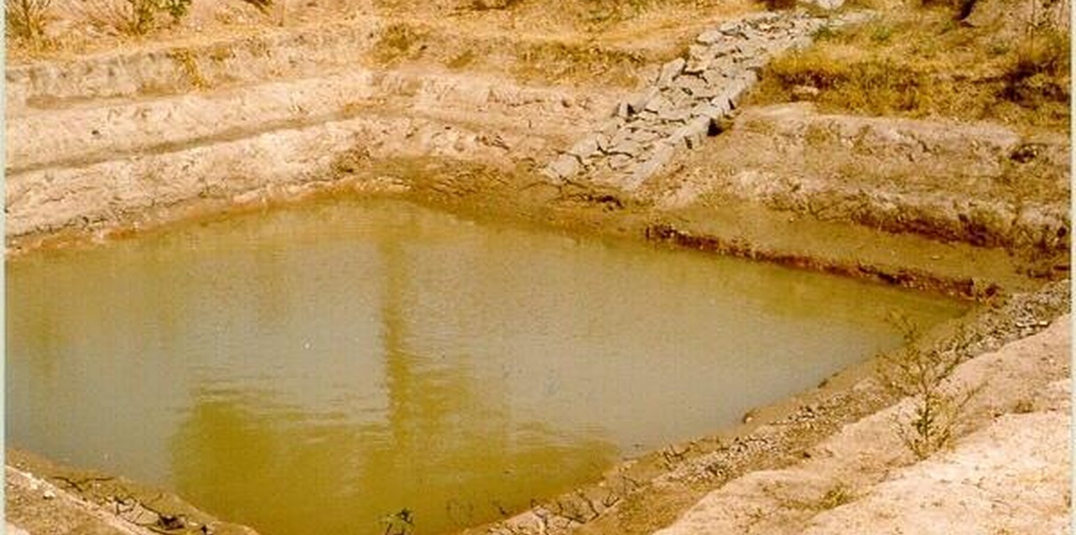
Photo of the farmpond (2-year old) showing the 1:1 side slope steps of 0.6 m dimension and the spilway Inlet cum Outlet. (C.G. Metri, JPO, KWDP Danida)

Farm pond (อินเดีย)

krushi honda (Kannada)

คำอธิบาย

A sunken structure (12 x 12 x 3 m, more suiable), constructed by escavation in arable land with a view of temporary runoff storage tapped for protective irrigation, and to increase percolation for recharge of ground water (to convert surface to subsurface flow)

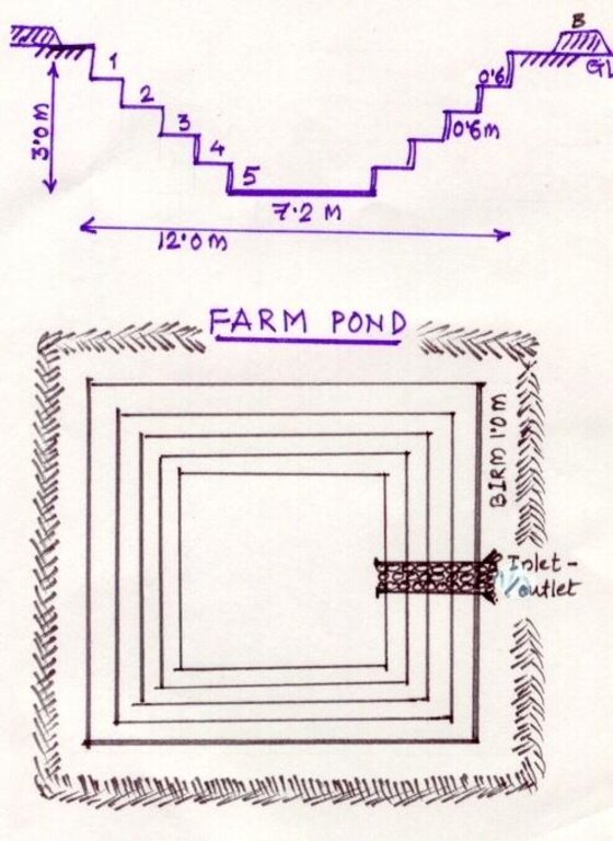
A farm pond comprises of excavated portions of 12 x 12 x 3 m with the steps at 0.6m depth each. The excavated earth is deposited all around the structure as a bund, with a burm space of 1m. An inlet cum outlet provided in the course of flow of rain water to collect and dispose the excess runoff.

Purpose of the Technology: (1). For storage of exess runoff. (2) to increase percolation for ground water recharge, (3). To use for protective irrigation during dry period, (4). To stop further deepening of watercourse in arable lands

Establishment / maintenance activities and inputs: Selection of beneficiary is by the community and site selection, Design/ layout and excavation by the project staff with participation of the beneficiary. Desilting of the structure is by the beneficiary

Natural / human environment: surrounding lands are more slopy and with exposed rocks, most of the surrounding area is left for grazing

สถานที่

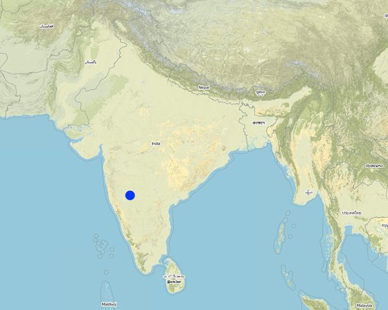
สถานที่: Bijapur district, Hadalsang village, Karnataka, อินเดีย

ตำนวนการวิเคราะห์เทคโนโลยี:

ตำแหน่งทางภูมิศาสตร์ของสถานที่ที่ถูกเลือ
  • 75.706, 16.8139

การเผยแพร่ของเทคโนโลยี: กระจายไปอย่างสม่ำเสมอในพื้นที่ (0.028 km²)

In a permanently protected area?:

วันที่ในการดำเนินการ: น้อยกว่า 10 ปี (ไม่นานนี้)

ประเภทของการแนะนำ

การจำแนกประเภทเทคโนโลยี

จุดประสงค์หลัก
  • ปรับปรุงการผลิตให้ดีขึ้น
  • ลด ป้องกัน ฟื้นฟู การเสื่อมโทรมของที่ดิน
  • อนุรักษ์ระบบนิเวศน์
  • ป้องกันพื้นที่ลุ่มน้ำ/บริเวณท้ายน้ำ โดยร่วมกับเทคโนโลยีอื่นๆ
  • รักษาสภาพหรือปรับปรุงความหลากหลายทางชีวภาพ
  • ลดความเสี่ยงของภัยพิบัติ
  • ปรับตัวเข้ากับการเปลี่ยนแปลงภูมิอากาศของโลก สภาพภูมิอากาศที่รุนแรงและผลกระทบ
  • ชะลอการเปลี่ยนแปลงภูมิอากาศของโลกและผลกระทบ
  • สร้างผลกระทบทางด้านเศรษฐกิจที่เป็นประโยชน์
  • สร้างผลกระทบทางด้านสังคมที่เป็นประโยชน์
การใช้ที่ดิน

  • พื้นที่ปลูกพืช
    • การปลูกพืชล้มลุกอายุปีเดียว: cereals - sorghum, legumes and pulses - other, oilseed crops - castor, Chili, brinjal (eggplants), lady's finger (okra, kind of peas)
    จำนวนของฤดูเพาะปลูกต่อปี: 2

การใช้น้ำ
  • จากน้ำฝน
  • น้ำฝนร่วมกับการชลประทาน
  • การชลประทานแบบเต็มรูปแบบ

ความมุ่งหมายที่เกี่ยวข้องกับการเสื่อมโทรมของที่ดิน
  • ป้องกันความเสื่อมโทรมของที่ดิน
  • ลดความเสื่อมโทรมของดิน
  • ฟื้นฟูบำบัดที่ดินที่เสื่อมโทรมลงอย่างมาก
  • ปรับตัวกับสภาพความเสื่อมโทรมของที่ดิน
  • ไม่สามารถใช้ได้
ที่อยู่ของการเสื่อมโทรม
  • การกัดกร่อนของดินโดยน้ำ - Wt (Loss of topsoil): การสูญเสียดินชั้นบนหรือการกัดกร่อนที่ผิวดิน , Wg (Gully erosion): การกัดกร่อนแบบร่องธารหรือการทำให้เกิดร่องน้ำเซาะ, Wo (Offsite degradation): ผลกระทบนอกพื้นที่
กลุ่ม SLM
  • การเก็บเกี่ยวน้ำ
  • การจัดการด้านชลประทาน (รวมถึงการลำเลียงส่งน้ำ การระบายน้ำ)
มาตรการ SLM

แบบแปลนทางเทคนิค

ข้อมูลจำเพาะด้านเทคนิค
The drawing showing the details of the farm pond. 12 x 12 x 3 m dimension. Five steps cutting on each side with 1:1 side slope. 1m birm (space) between the earthen bund. 1m wide spilway inlet cum outlet at suitable place of the site.

Location: Kallahalla nala watershed, Indi Taluk. Bijapur district of Karnataka state

Date: 20.4.2004

Technical knowledge required for field staff / advisors: moderate

Technical knowledge required for land users: high

Main technical functions: water harvesting / increase water supply

Secondary technical functions: increase of infiltration, increase / maintain water stored in soil

Structural measure: sediment sand / trap
Depth of ditches/pits/dams (m): 3
Width of ditches/pits/dams (m): 15
Length of ditches/pits/dams (m): 15
Height of bunds/banks/others (m): 1
Width of bunds/banks/others (m): 1
Length of bunds/banks/others (m): 15

Construction material (earth): soil excavated from the pond is used to for bunds all around the structure with 1 m birm space.

Construction material (stone): The spillway Inlet cum Outlet is constructed using stones

For water harvesting: the ratio between the area where the harvested water is applied and the total area from which water is collected is: 1:7

Vegetation is used for stabilisation of structures.
Author: C.G Metri, JPO, KWDP Danida Bi

การจัดตั้งและการบำรุงรักษา: กิจกรรม ปัจจัยและค่าใช้จ่าย

การคำนวนต้นทุนและค่าใช้จ่าย
  • ค่าใช้จ่ายถูกคำนวน
  • สกุลเงินที่ใช้คำนวณค่าใช้จ่าย Ruppes
  • อัตราแลกเปลี่ยน (ไปเป็นดอลลาร์สหรัฐ) คือ 1 ดอลลาร์สหรัฐ = 46.0 Ruppes
  • ค่าจ้างเฉลี่ยในการจ้างแรงงานต่อวันคือ 0.73
ปัจจัยที่สำคัญที่สุดที่มีผลต่อค่าใช้จ่าย
If the implementation site is having the hard strata, then the cost will be more.
กิจกรรมเพื่อการจัดตั้ง
  1. selection of site and survey, preparation of estimates (ช่วงระยะเวลา/ความถี่: summer)
  2. submission for sanction of approval (ช่วงระยะเวลา/ความถี่: summer)
  3. Excavation of the farmpond (ช่วงระยะเวลา/ความถี่: summer)
  4. construction of inlet/ outlet (ช่วงระยะเวลา/ความถี่: before monsoon starts)
ปัจจัยและค่าใช้จ่ายของการจัดตั้ง
ปัจจัยนำเข้า หน่วย ปริมาณ ค่าใช้จ่ายต่อหน่วย (Ruppes) ค่าใช้จ่ายทั้งหมดต่อปัจจัยนำเข้า (Ruppes) %ของค่าใช้จ่ายที่ก่อให้เกิดขึ้นโดยผู้ใช้ที่ดิน
แรงงาน
Labour ha 1.0 360.0 360.0 10.0
วัสดุสำหรับก่อสร้าง
Stone ha 1.0 109.43 109.43 100.0
ค่าใช้จ่ายทั้งหมดของการจัดตั้งเทคโนโลยี 469.43
Total costs for establishment of the Technology in USD 10.21
กิจกรรมสำหรับการบำรุงรักษา
  1. Meeting with the farmer (ช่วงระยะเวลา/ความถี่: monsoon/annual)
  2. Desilting of farmpond (ช่วงระยะเวลา/ความถี่: summer season/once in 2 years)
  3. Repair of Inlet/Outlet (ช่วงระยะเวลา/ความถี่: summer season/Every year)
  4. Trimming of Bund (ช่วงระยะเวลา/ความถี่: summer season/Every year)
ปัจจัยและค่าใช้จ่ายของการบำรุงรักษา
ปัจจัยนำเข้า หน่วย ปริมาณ ค่าใช้จ่ายต่อหน่วย (Ruppes) ค่าใช้จ่ายทั้งหมดต่อปัจจัยนำเข้า (Ruppes) %ของค่าใช้จ่ายที่ก่อให้เกิดขึ้นโดยผู้ใช้ที่ดิน
แรงงาน
Labour ha 1.0 7.3 7.3 100.0
ค่าใช้จ่ายทั้งหมดของการบำรุงรักษาสภาพเทคโนโลยี 7.3
Total costs for maintenance of the Technology in USD 0.16

สิ่งแวดล้อมทางธรรมชาติ

ปริมาณน้ำฝนเฉลี่ยรายปี
  • < 250 ม.ม.
  • 251-500 ม.ม.
  • 501-750 ม.ม.
  • 751-1,000 ม.ม.
  • 1,001-1,500 ม.ม.
  • 1,501-2,000 ม.ม.
  • 2,001-3,000 ม.ม.
  • 3,001-4,000 ม.ม.
  • > 4,000 ม.ม.
เขตภูมิอากาศเกษตร
  • ชื้น
  • กึ่งชุ่มชื้น
  • กึ่งแห้งแล้ง
  • แห้งแล้ง
ข้อมูลจำเพาะเรื่องภูมิอากาศ
ปริมาณเฉลี่ยฝนรายปีในหน่วยมม. 550.0
Located on the latitude 16-49'N and longitude 75-43'E .Characterised by hot dry summer (42 °C) and cold dry winters monsoon (July-September) is characterised by high intensity showers followed by pro
ความชัน
  • ราบเรียบ (0-2%)
  • ลาดที่ไม่ชัน (3-5%)
  • ปานกลาง (6-10%)
  • เป็นลูกคลื่น (11-15%)
  • เป็นเนิน (16-30%)
  • ชัน (31-60%)
  • ชันมาก (>60%)
ภูมิลักษณ์
  • ที่ราบสูง/ที่ราบ
  • สันเขา
  • ไหล่เขา
  • ไหล่เนินเขา
  • ตีนเนิน
  • หุบเขา
ความสูง
  • 0-100 เมตร
  • 101-500 เมตร
  • 501-1,000 เมตร
  • 1,001-1,500 เมตร
  • 1,501-2,000 เมตร
  • 2,001-2,500 เมตร
  • 2,501-3,000 เมตร
  • 3,001-4,000 เมตร
  • > 4,000 เมตร
เทคโนโลยีถูกประยุกต์ใช้ใน
  • บริเวณสันเขา (convex situations)
  • บริเวณแอ่งบนที่ราบ (concave situations)
  • ไม่เกี่ยวข้อง
ความลึกของดิน
  • ตื้นมาก (0-20 ซ.ม.)
  • ตื้น (21-50 ซ.ม.)
  • ลึกปานกลาง (51-80 ซ.ม.)
  • ลึก (81-120 ซ.ม.)
  • ลึกมาก (>120 ซ.ม.)
เนื้อดิน (ดินชั้นบน)
  • หยาบ/เบา (ดินทราย)
  • ปานกลาง (ดินร่วน ทรายแป้ง)
  • ละเอียด/หนัก (ดินเหนียว)
เนื้อดิน (> 20 ซม. ต่ำกว่าพื้นผิว)
  • หยาบ/เบา (ดินทราย)
  • ปานกลาง (ดินร่วน ทรายแป้ง)
  • ละเอียด/หนัก (ดินเหนียว)
สารอินทรียวัตถุในดิน
  • สูง (>3%)
  • ปานกลาง (1-3%)
  • ต่ำ (<1%)
น้ำบาดาล
  • ที่ผิวดิน
  • <5 เมตร
  • 5-50 เมตร
  • > 50 เมตร
ระดับน้ำบาดาลที่ผิวดิน
  • เกินพอ
  • ดี
  • ปานกลาง
  • ไม่ดีหรือไม่มีเลย
คุณภาพน้ำ (ยังไม่ได้รับการบำบัด)
  • เป็นน้ำเพื่อการดื่มที่ดี
  • เป็นน้ำเพื่อการดื่มที่ไม่ดี (จำเป็นต้องได้รับการบำบัด)
  • เป็นน้ำใช้เพื่อการเกษตรเท่านั้น (การชลประทาน)
  • ใช้ประโยชน์ไม่ได้
ความเค็มของน้ำเป็นปัญหาหรือไม่?
  • ใช่
  • ไม่ใช่

การเกิดน้ำท่วม
  • ใช่
  • ไม่ใช่
ความหลากหลายทางชนิดพันธุ์
  • สูง
  • ปานกลาง
  • ต่ำ
ความหลากหลายของแหล่งที่อยู่
  • สูง
  • ปานกลาง
  • ต่ำ

ลักษณะเฉพาะของผู้ใช้ที่ดินที่ประยุกต์ใช้เทคโนโลยี

เป้าหมายทางการตลาด
  • เพื่อการยังชีพ (หาเลี้ยงตนเอง)
  • mixed (subsistence/ commercial)
  • ทำการค้า/การตลาด
รายได้จากภายนอกฟาร์ม
  • < 10% ของรายได้ทั้งหมด
  • 10-50% ของรายได้ทั้งหมด
  • > 50% ของรายได้ทั้งหมด
ระดับของความมั่งคั่งโดยเปรียบเทียบ
  • ยากจนมาก
  • จน
  • พอมีพอกิน
  • รวย
  • รวยมาก
ระดับของการใช้เครื่องจักรกล
  • งานที่ใช้แรงกาย
  • การใช้กำลังจากสัตว์
  • การใช้เครื่องจักรหรือเครื่องยนต์
อยู่กับที่หรือเร่ร่อน
  • อยู่กับที่
  • กึ่งเร่ร่อน
  • เร่ร่อน
เป็นรายบุคคลหรือกลุ่ม
  • เป็นรายบุคคล/ครัวเรือน
  • กลุ่ม/ชุมชน
  • สหกรณ์
  • ลูกจ้าง (บริษัท รัฐบาล)
เพศ
  • หญิง
  • ชาย
อายุ
  • เด็ก
  • ผู้เยาว์
  • วัยกลางคน
  • ผู้สูงอายุ
พื้นที่ที่ใช้ต่อครัวเรือน
  • < 0.5 เฮกตาร์
  • 0.5-1 เฮกตาร์
  • 1-2 เฮกตาร์
  • 2-5 เฮกตาร์
  • 5-15 เฮกตาร์
  • 15-50 เฮกตาร์
  • 50-100 เฮกตาร์
  • 100-500 เฮกตาร์
  • 500-1,000 เฮกตาร์
  • 1,000-10,000 เฮกตาร์
  • >10,000 เฮกตาร์
ขนาด
  • ขนาดเล็ก
  • ขนาดกลาง
  • ขนาดใหญ่
กรรมสิทธิ์ในที่ดิน
  • รัฐ
  • บริษัท
  • เป็นแบบชุมชนหรือหมู่บ้าน
  • กลุ่ม
  • รายบุคคล ไม่ได้รับสิทธิครอบครอง
  • รายบุคคล ได้รับสิทธิครอบครอง
สิทธิในการใช้ที่ดิน
  • เข้าถึงได้แบบเปิด (ไม่ได้จัดระเบียบ)
  • เกี่ยวกับชุมชน (ถูกจัดระเบียบ)
  • เช่า
  • รายบุคคล
สิทธิในการใช้น้ำ
  • เข้าถึงได้แบบเปิด (ไม่ได้จัดระเบียบ)
  • เกี่ยวกับชุมชน (ถูกจัดระเบียบ)
  • เช่า
  • รายบุคคล
เข้าถึงการบริการและโครงสร้างพื้นฐาน

ผลกระทบ

ผลกระทบทางด้านเศรษฐกิจและสังคม
การผลิตพืชผล
ลดลง
เพิ่มขึ้น


Second crop also taken

การผลิตพืชที่ใช้เลี้ยงปศุสัตว์
ลดลง
เพิ่มขึ้น


From trees

คุณภาพพืชที่ใช้เลี้ยงปศุสัตว์
ลดลง
เพิ่มขึ้น


From trees

ความหลากหลายของผลิตภัณฑ์
ลดลง
เพิ่มขึ้น


Difference in the crop like on bunds and in the patches of crops.

พื้นที่สำหรับการผลิต (ที่ดินใหม่ที่อยู่ในระหว่างเพาะปลูกหรือใช้งาน)
ลดลง
เพิ่มขึ้น


15m x 15m land loss average land holding is very less, thus small & marginal farmers face reduction in the production area with this SWC

การจัดการที่ดิน
ขัดขวาง
ทำให้ง่ายขึ้น


After implementing SWC less area is left for very small and marginal land holding.

การมีน้ำไว้ให้ปศุสัตว์
ลดลง
เพิ่มขึ้น

รายได้จากฟาร์ม
ลดลง
เพิ่มขึ้น


Subsistance agriculture

Input constraints
increased
decreased


To bring new area into cultivation

ผลกระทบด้านสังคมและวัฒนธรรม
SLM หรือความรู้เรื่องความเสื่อมโทรมของที่ดิน
ลดลง
ปรับปรุงดีขึ้น

ผลกระทบด้านนิเวศวิทยา
การระบายน้ำส่วนเกิน
ลดลง
ปรับปรุงดีขึ้น

ความชื้นในดิน
ลดลง
เพิ่มขึ้น

สิ่งปกคลุมดิน
ลดลง
ปรับปรุงดีขึ้น

การสูญเสียดิน
เพิ่มขึ้น
ลดลง

Soil fertility
decreased
increased

ผลกระทบนอกพื้นที่ดำเนินการ
การไหลของน้ำคงที่และสม่ำเสมอในช่วงฤดูแล้ง(รวมถึงการไหลน้อย)
ลดลง
เพิ่มขึ้น

น้ำท่วมพื้นที่ท้ายน้ำ (ที่ไม่เป็นที่ต้องการ)
เพิ่มขึ้น
ลดลง


Water storage in farm pond

รายได้และค่าใช้จ่าย

ผลประโยชน์ที่ได้รับเปรียบเทียบกับค่าใช้จ่าย
ผลตอบแทนระยะสั้น
ด้านลบอย่างมาก
ด้านบวกอย่างมาก

ผลตอบแทนระยะยาว
ด้านลบอย่างมาก
ด้านบวกอย่างมาก

ผลประโยชน์ที่ได้รับเปรียบเทียบกับค่าใช้จ่ายในการบำรุงรักษา
ผลตอบแทนระยะสั้น
ด้านลบอย่างมาก
ด้านบวกอย่างมาก

ผลตอบแทนระยะยาว
ด้านลบอย่างมาก
ด้านบวกอย่างมาก

การเปลี่ยนแปลงของสภาพภูมิอากาศ

-

การน้อมเอาความรู้และการปรับใช้

เปอร์เซ็นต์ของผู้ใช้ที่ดินในพื้นที่ที่นำเทคโนโลยีไปใช้
  • ครั้งเดียวหรือเป็นการทดลอง
  • 1-10%
  • 11-50%
  • > 50%
จากทั้งหมดที่ได้รับเทคโนโลยีเข้ามามีจำนวนเท่าใดที่ทำแบบทันที โดยไม่ได้รับการจูงใจด้านวัสดุหรือการเงินใดๆ?
  • 0-10%
  • 11-50%
  • 51-90%
  • 91-100%
เทคโนโลยีได้รับการปรับเปลี่ยนเร็วๆ นี้เพื่อให้ปรับตัวเข้ากับสภาพที่กำลังเปลี่ยนแปลงหรือไม่?
  • ใช่
  • ไม่ใช่
สภาพที่กำลังเปลี่ยนแปลงอันไหน?
  • การเปลี่ยนแปลงแบบค่อยเป็นค่อยไปและสภาพรุนแรงของภูมิอากาศ
  • การเปลี่ยนแปลงของตลาด
  • การมีแรงงานไว้ให้ใช้ (เนื่องจากการอพยพย้ายถิ่นฐาน)

บทสรุปหรือบทเรียนที่ได้รับ

จุดแข็ง: มุมมองของผู้ใช้ที่ดิน
  • Increased storage of water

    How can they be sustained / enhanced? Desilting by the farmer
  • Reduce gully formation
  • Bring more area under irrigation

    How can they be sustained / enhanced? By giving life saving irrigation
  • Economic benefits

    How can they be sustained / enhanced? By yields (monocropping to multiple cropping) --> more income
  • Recycle the silt is beneficial

    How can they be sustained / enhanced? Other the silt would been lost every year and it is good to retain the soil fertility.
จุดแข็ง: ทัศนคติของผู้รวบรวมหรือวิทยากรคนอื่นๆ
  • Storage of water

    How can they be sustained / enhanced? By deepening
  • Reduced runoff velocity

    How can they be sustained / enhanced? By mentainance
  • Breaching of bunds down stream

    How can they be sustained / enhanced? By reducing the run-off
  • Replicability

    How can they be sustained / enhanced? if a famer has his own labour/ man power then he can go for its construction.
  • Water harvesting

    How can they be sustained / enhanced? recycle for protective irrigation during peak season.
จุดด้อย/ข้อเสีย/ความเสี่ยง: มุมมองของผู้ใช้ที่ดินแก้ไขปัญหาได้อย่างไร
  • Inability to contribute 100% towards cost of construction. By giving schemes / financial assistance
  • Loosing of portion of cultivable land By utilizing bunds, change in cropping system/ cropping pattern etc.
จุดด้อย/ข้อเสีย/ความเสี่ยง: ทัศนคติของผู้รวบรวมหรือวิทยากรคนอื่นๆแก้ไขปัญหาได้อย่างไร
  • Difficult to excavate in hard strata can be done in shallow soils
  • Silt accumulation, if upper catchment is not treated Treatment of upper catchment

การอ้างอิง

ผู้รวบรวม
  • Channabasappa Metri
Editors
ผู้ตรวจสอบ
  • Fabian Ottiger
  • Alexandra Gavilano
วันที่จัดทำเอกสาร: 3 มิถุนายน 2011
การอัพเดทล่าสุด: 4 กันยายน 2019
วิทยากร
คำอธิบายฉบับเต็มในฐานข้อมูล WOCAT
ข้อมูล SLM ที่ถูกอ้างอิง
การจัดทำเอกสารถูกทำโดย
องค์กร โครงการ
การอ้งอิงหลัก
  • Department Guidelines,Project Implementation plan, UAS Dharwad: In the office, personal contact
  • PIP: in the office
  • University of Agril. Sciences Dharwad: personal contact
This work is licensed under Creative Commons Attribution-NonCommercial-ShareaAlike 4.0 International