Improved terraces
(เนปาล)
GARA SUDHAR- Nepali
คำอธิบาย
Hillside forward-sloping terracing and stabilisation using structural and vegetative measures
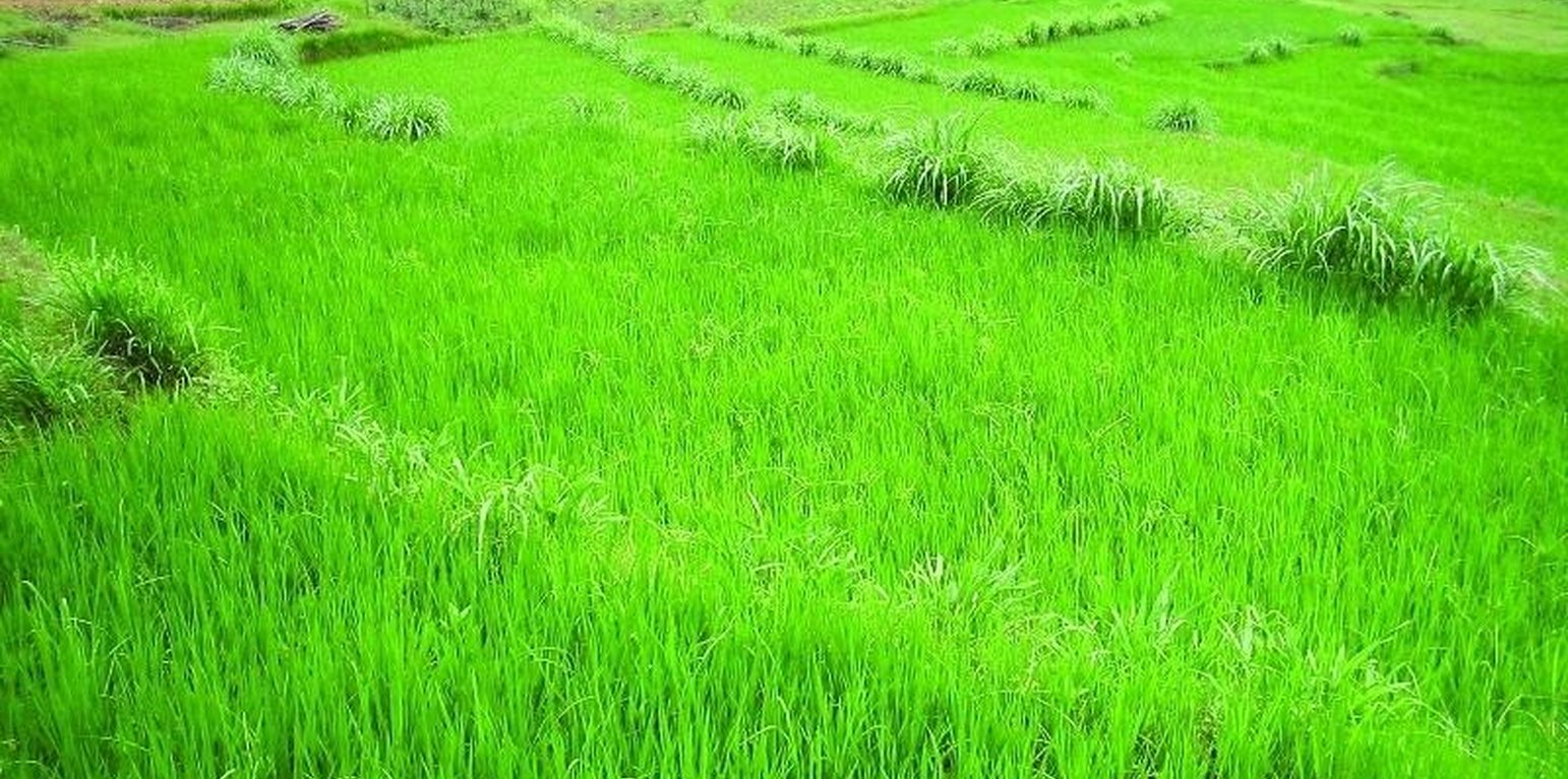
This technology addresses the soil erosion and water runoff problems associated with traditional outward-sloping terraces by reshaping the land into a series of level or gently sloping platforms across the slope. This technology is a variant of sloping land agricultural technology (SALT) or contour hedgerow technology. Nitrogen-fixing hedgerow species and quality fodder grass species, which bind the soil, are cultivated along terrace riser margins to improve terrace stability. This also enhances soil fertility and increases fodder availability. The plants are grown in either single or multiple layers. The practice is applied under rainfed conditions and is culturally acceptable and affordable. After establishment, the technology also addresses the problems of fodder scarcity making it easier and less time consuming for women and girls to gather fodder.
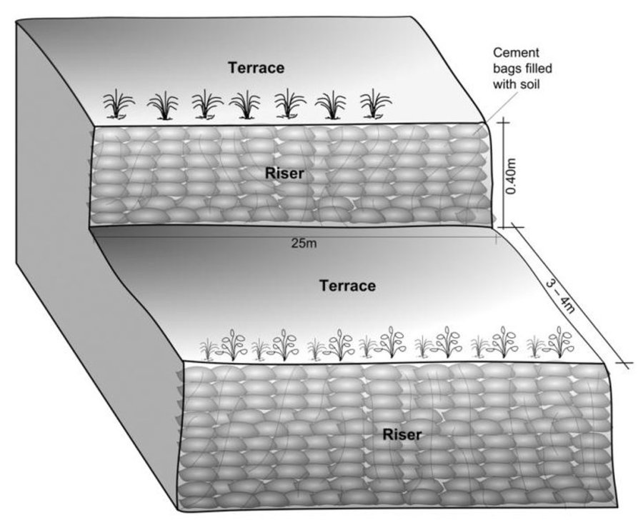
The hedgerow and grass species are established between January and June. Complete establishment of this technology may take one year. The first step in creating the terraces is to build retaining walls using cement bags filled with soil which are then supported with bamboo cuttings along the contour (= future terrace risers). This divides the land into the planned terrace sections. The length and width of the terraces depends on the size and shape of the original field. Secondly, the soil is excavated from the upper part of the terraces and is used to build up the lower part above and behind the terrace riser wall to create a level bed. The fertile top soil must be kept aside and later spread over the newly terraced fields. The final step is to plant grass and hedgerow species on the outermost margins of the terrace above the risers.
Maintenance involves slicing the terrace risers once or twice a year with a spade, and smoothing off rills that appear on the surface of terraces after the premonsoon and monsoon periods. Hedgerows should be cut regularly but not more than twice a year, normally to a height of about 50 cm. Grasses should be cut about once to twice a month depending on their rate of growth.
The technology is applied under humid subtropical climate conditions (1300 mm annual rainfall with about 80% of it falling in the monsoon months of June - September). The case study area has hill slopes of 16-30% that are mostly highly erodible red soils (FAO classification: luvisols).
สถานที่
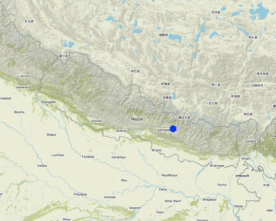
สถานที่: Hokse VDC ward no2, เนปาล
ตำนวนการวิเคราะห์เทคโนโลยี:
ตำแหน่งทางภูมิศาสตร์ของสถานที่ที่ถูกเลือ
การเผยแพร่ของเทคโนโลยี: กระจายไปอย่างสม่ำเสมอในพื้นที่ (0.0126 km²)
In a permanently protected area?:
วันที่ในการดำเนินการ: มากกว่า 50 ปี (แบบดั้งเดิม)
ประเภทของการแนะนำ
-
ด้วยการริเริ่มของผู้ใช้ที่ดินเอง
-
เป็นส่วนหนึ่งของระบบแบบดั้งเดิมที่ทำก้นอยู่ (> 50 ปี)
-
ในช่วงการทดลองหรือการทำวิจัย
-
ทางโครงการหรือจากภายนอก
จุดประสงค์หลัก
-
ปรับปรุงการผลิตให้ดีขึ้น
-
ลด ป้องกัน ฟื้นฟู การเสื่อมโทรมของที่ดิน
-
อนุรักษ์ระบบนิเวศน์
-
ป้องกันพื้นที่ลุ่มน้ำ/บริเวณท้ายน้ำ โดยร่วมกับเทคโนโลยีอื่นๆ
-
รักษาสภาพหรือปรับปรุงความหลากหลายทางชีวภาพ
-
ลดความเสี่ยงของภัยพิบัติ
-
ปรับตัวเข้ากับการเปลี่ยนแปลงภูมิอากาศของโลก สภาพภูมิอากาศที่รุนแรงและผลกระทบ
-
ชะลอการเปลี่ยนแปลงภูมิอากาศของโลกและผลกระทบ
-
สร้างผลกระทบทางด้านเศรษฐกิจที่เป็นประโยชน์
-
สร้างผลกระทบทางด้านสังคมที่เป็นประโยชน์
การใช้ที่ดิน
-
พื้นที่ปลูกพืช
- การปลูกพืชล้มลุกอายุปีเดียว: cereals - maize, legumes and pulses - beans, root/tuber crops - potatoes, wheat, chili, tomatoes
จำนวนของฤดูเพาะปลูกต่อปี: 3
การใช้น้ำ
-
จากน้ำฝน
-
น้ำฝนร่วมกับการชลประทาน
-
การชลประทานแบบเต็มรูปแบบ
ความมุ่งหมายที่เกี่ยวข้องกับการเสื่อมโทรมของที่ดิน
-
ป้องกันความเสื่อมโทรมของที่ดิน
-
ลดความเสื่อมโทรมของดิน
-
ฟื้นฟูบำบัดที่ดินที่เสื่อมโทรมลงอย่างมาก
-
ปรับตัวกับสภาพความเสื่อมโทรมของที่ดิน
-
ไม่สามารถใช้ได้
ที่อยู่ของการเสื่อมโทรม
-
การกัดกร่อนของดินโดยน้ำ - Wt (Loss of topsoil): การสูญเสียดินชั้นบนหรือการกัดกร่อนที่ผิวดิน , Wg (Gully erosion): การกัดกร่อนแบบร่องธารหรือการทำให้เกิดร่องน้ำเซาะ
-
การเสื่อมโทรมของน้ำ - Ha (Aridification): การเกิดความแห้งแล้ง
กลุ่ม SLM
-
มาตรการปลูกพืชขวางความลาดชัน (cross-slope measure)
-
การผันน้ำและการระบายน้ำ
มาตรการ SLM
-
มาตรการอนุรักษ์ด้วยวิธีพืช - V1: ต้นไม้และพุ่มไม้คลุมดิน
-
มาตรการอนุรักษ์ด้วยโครงสร้าง - S1: คันดิน
แบบแปลนทางเทคนิค
ข้อมูลจำเพาะด้านเทคนิค
Schematric view after intervention [terracing and vegetative measures]
Riser slope: 75 degree
Terrace slope: ~ 2 degree
Location: Kubinde
Technical knowledge required for field staff / advisors: high
Technical knowledge required for land users: moderate
Main technical functions: control of concentrated runoff: impede / retard, reduction of slope angle, reduction of slope length
Secondary technical functions: increase of infiltration, increase / maintain water stored in soil, increase in soil fertility
Vegetative measure: on risers
Vegetative material: T : trees / shrubs, G : grass
Number of plants per (ha): 2500
Vertical interval between rows / strips / blocks (m): 1.5
Spacing between rows / strips / blocks (m): 3 to 4
Vertical interval within rows / strips / blocks (m): 0.25
Vegetative measure: Vegetative material: T : trees / shrubs, G : grass
Vegetative measure: Vegetative material: T : trees / shrubs, G : grass
Vegetative measure: Vegetative material: T : trees / shrubs, G : grass
Trees/ shrubs species: Sunhemp(Crotalaria juncea),Tephrosia (Tephrosia candida) and Flemingia (Flemingia microphylla)
Grass species: Napier(Pennisetum purpureum),Molasses (Melinis minutiflora) and Stylo(Stylosanthes guianensis)
Slope (which determines the spacing indicated above): 5.00%
If the original slope has changed as a result of the Technology, the slope today is (see figure below): 5.00%
Gradient along the rows / strips: 75.00%
Terrace: bench level
Vertical interval between structures (m): 1.5
Width of ditches/pits/dams (m): 3-4
Length of ditches/pits/dams (m): 10-15
Construction material (earth): Cement bag filled with soil, Bamboo nets were used to make risers.
Slope (which determines the spacing indicated above): 30%
If the original slope has changed as a result of the Technology, the slope today is: 5%
Vegetation is used for stabilisation of structures.
Author: Madhav Dhakal, A. K. Thaku
การจัดตั้งและการบำรุงรักษา: กิจกรรม ปัจจัยและค่าใช้จ่าย
การคำนวนต้นทุนและค่าใช้จ่าย
- ค่าใช้จ่ายถูกคำนวน
- สกุลเงินที่ใช้คำนวณค่าใช้จ่าย USD
- อัตราแลกเปลี่ยน (ไปเป็นดอลลาร์สหรัฐ) คือ 1 ดอลลาร์สหรัฐ = -1.0
- ค่าจ้างเฉลี่ยในการจ้างแรงงานต่อวันคือ 1.40
ปัจจัยที่สำคัญที่สุดที่มีผลต่อค่าใช้จ่าย
In case of projects interested in promoting this technology in the region, the labour cost is the major expenditure in the initial stage.The labour charges are decided by the district soil conservation office.
กิจกรรมเพื่อการจัดตั้ง
-
Area estimation ( for vegetative measures) (ช่วงระยะเวลา/ความถี่: before rainy seasonn/lean period (February))
-
Selection of fodder grass species (ช่วงระยะเวลา/ความถี่: Before rainy season (Feb))
-
Planting of grasses and hedgerow species on the outward margins (ช่วงระยะเวลา/ความถี่: During rainy season.)
-
Establishment of riser, using cement bags (filled with soil) and bamboo culms for terrace stabilisation (ช่วงระยะเวลา/ความถี่: Beginning of rainy season(May))
-
Terrace leveling:The length and width of the terraces depends on the size and shape of the field. Excavate soil from the upper part of the terrace field and use it to build up the lower part behind the terrace riser wallt creat a level plateform/bed. (ช่วงระยะเวลา/ความถี่: Beginning of rainy season(May))
ปัจจัยและค่าใช้จ่ายของการจัดตั้ง
| ปัจจัยนำเข้า |
หน่วย |
ปริมาณ |
ค่าใช้จ่ายต่อหน่วย (USD) |
ค่าใช้จ่ายทั้งหมดต่อปัจจัยนำเข้า (USD) |
%ของค่าใช้จ่ายที่ก่อให้เกิดขึ้นโดยผู้ใช้ที่ดิน |
|
แรงงาน
|
| Labour |
ha |
1.0 |
970.0 |
970.0 |
50.0 |
|
อุปกรณ์
|
| Total costs |
ha |
1.0 |
92.0 |
92.0 |
100.0 |
|
วัสดุด้านพืช
|
| Seeds |
ha |
1.0 |
25.0 |
25.0 |
|
| Seedlings |
ha |
1.0 |
30.0 |
30.0 |
|
| Bamboo |
culms |
80.0 |
1.0 |
80.0 |
50.0 |
|
วัสดุสำหรับก่อสร้าง
|
| Cement bags |
ha |
1.0 |
80.0 |
80.0 |
50.0 |
|
อื่น ๆ
|
| Supervision charge |
ha |
1.0 |
10.5 |
10.5 |
|
| ค่าใช้จ่ายทั้งหมดของการจัดตั้งเทคโนโลยี |
1'287.5 |
|
| Total costs for establishment of the Technology in USD |
-1'287.5 |
|
กิจกรรมสำหรับการบำรุงรักษา
-
Hedgerow/grass maintenance: Hedgerows are cut regularly but not (ช่วงระยะเวลา/ความถี่: Grass is cut once or twice a month.)
-
(Re)plantation of hedge species if necessary (ช่วงระยะเวลา/ความถี่: Before monsoon /1*/year)
-
Surface and riser maintenance: smooth the surface/rills on the (ช่วงระยะเวลา/ความถี่: after pre monsoon and after monsoon/2 */ year ,Jun)
ปัจจัยและค่าใช้จ่ายของการบำรุงรักษา
| ปัจจัยนำเข้า |
หน่วย |
ปริมาณ |
ค่าใช้จ่ายต่อหน่วย (USD) |
ค่าใช้จ่ายทั้งหมดต่อปัจจัยนำเข้า (USD) |
%ของค่าใช้จ่ายที่ก่อให้เกิดขึ้นโดยผู้ใช้ที่ดิน |
|
แรงงาน
|
| Labour |
ha |
1.0 |
310.0 |
310.0 |
100.0 |
|
อุปกรณ์
|
| Tools total costs |
ha |
1.0 |
20.0 |
20.0 |
100.0 |
|
วัสดุด้านพืช
|
| Seeds |
ha |
1.0 |
6.0 |
6.0 |
100.0 |
| Seedlings |
ha |
1.0 |
6.0 |
6.0 |
100.0 |
| ค่าใช้จ่ายทั้งหมดของการบำรุงรักษาสภาพเทคโนโลยี |
342.0 |
|
| Total costs for maintenance of the Technology in USD |
-342.0 |
|
สิ่งแวดล้อมทางธรรมชาติ
ปริมาณน้ำฝนเฉลี่ยรายปี
-
< 250 ม.ม.
-
251-500 ม.ม.
-
501-750 ม.ม.
-
751-1,000 ม.ม.
-
1,001-1,500 ม.ม.
-
1,501-2,000 ม.ม.
-
2,001-3,000 ม.ม.
-
3,001-4,000 ม.ม.
-
> 4,000 ม.ม.
เขตภูมิอากาศเกษตร
-
ชื้น
-
กึ่งชุ่มชื้น
-
กึ่งแห้งแล้ง
-
แห้งแล้ง
ข้อมูลจำเพาะเรื่องภูมิอากาศ
ปริมาณเฉลี่ยฝนรายปีในหน่วยมม. 1304.0
Thermal climate class: subtropics
ความชัน
-
ราบเรียบ (0-2%)
-
ลาดที่ไม่ชัน (3-5%)
-
ปานกลาง (6-10%)
-
เป็นลูกคลื่น (11-15%)
-
เป็นเนิน (16-30%)
-
ชัน (31-60%)
-
ชันมาก (>60%)
ภูมิลักษณ์
-
ที่ราบสูง/ที่ราบ
-
สันเขา
-
ไหล่เขา
-
ไหล่เนินเขา
-
ตีนเนิน
-
หุบเขา
ความสูง
-
0-100 เมตร
-
101-500 เมตร
-
501-1,000 เมตร
-
1,001-1,500 เมตร
-
1,501-2,000 เมตร
-
2,001-2,500 เมตร
-
2,501-3,000 เมตร
-
3,001-4,000 เมตร
-
> 4,000 เมตร
เทคโนโลยีถูกประยุกต์ใช้ใน
-
บริเวณสันเขา (convex situations)
-
บริเวณแอ่งบนที่ราบ (concave situations)
-
ไม่เกี่ยวข้อง
ความลึกของดิน
-
ตื้นมาก (0-20 ซ.ม.)
-
ตื้น (21-50 ซ.ม.)
-
ลึกปานกลาง (51-80 ซ.ม.)
-
ลึก (81-120 ซ.ม.)
-
ลึกมาก (>120 ซ.ม.)
เนื้อดิน (ดินชั้นบน)
-
หยาบ/เบา (ดินทราย)
-
ปานกลาง (ดินร่วน ทรายแป้ง)
-
ละเอียด/หนัก (ดินเหนียว)
เนื้อดิน (> 20 ซม. ต่ำกว่าพื้นผิว)
-
หยาบ/เบา (ดินทราย)
-
ปานกลาง (ดินร่วน ทรายแป้ง)
-
ละเอียด/หนัก (ดินเหนียว)
สารอินทรียวัตถุในดิน
-
สูง (>3%)
-
ปานกลาง (1-3%)
-
ต่ำ (<1%)
น้ำบาดาล
-
ที่ผิวดิน
-
<5 เมตร
-
5-50 เมตร
-
> 50 เมตร
ระดับน้ำบาดาลที่ผิวดิน
-
เกินพอ
-
ดี
-
ปานกลาง
-
ไม่ดีหรือไม่มีเลย
คุณภาพน้ำ (ยังไม่ได้รับการบำบัด)
-
เป็นน้ำเพื่อการดื่มที่ดี
-
เป็นน้ำเพื่อการดื่มที่ไม่ดี (จำเป็นต้องได้รับการบำบัด)
-
เป็นน้ำใช้เพื่อการเกษตรเท่านั้น (การชลประทาน)
-
ใช้ประโยชน์ไม่ได้
Water quality refers to:
ความเค็มของน้ำเป็นปัญหาหรือไม่?
การเกิดน้ำท่วม
ความหลากหลายทางชนิดพันธุ์
ความหลากหลายของแหล่งที่อยู่
ลักษณะเฉพาะของผู้ใช้ที่ดินที่ประยุกต์ใช้เทคโนโลยี
เป้าหมายทางการตลาด
-
เพื่อการยังชีพ (หาเลี้ยงตนเอง)
-
mixed (subsistence/ commercial)
-
ทำการค้า/การตลาด
รายได้จากภายนอกฟาร์ม
-
< 10% ของรายได้ทั้งหมด
-
10-50% ของรายได้ทั้งหมด
-
> 50% ของรายได้ทั้งหมด
ระดับของความมั่งคั่งโดยเปรียบเทียบ
-
ยากจนมาก
-
จน
-
พอมีพอกิน
-
รวย
-
รวยมาก
ระดับของการใช้เครื่องจักรกล
-
งานที่ใช้แรงกาย
-
การใช้กำลังจากสัตว์
-
การใช้เครื่องจักรหรือเครื่องยนต์
อยู่กับที่หรือเร่ร่อน
-
อยู่กับที่
-
กึ่งเร่ร่อน
-
เร่ร่อน
เป็นรายบุคคลหรือกลุ่ม
-
เป็นรายบุคคล/ครัวเรือน
-
กลุ่ม/ชุมชน
-
สหกรณ์
-
ลูกจ้าง (บริษัท รัฐบาล)
อายุ
-
เด็ก
-
ผู้เยาว์
-
วัยกลางคน
-
ผู้สูงอายุ
พื้นที่ที่ใช้ต่อครัวเรือน
-
< 0.5 เฮกตาร์
-
0.5-1 เฮกตาร์
-
1-2 เฮกตาร์
-
2-5 เฮกตาร์
-
5-15 เฮกตาร์
-
15-50 เฮกตาร์
-
50-100 เฮกตาร์
-
100-500 เฮกตาร์
-
500-1,000 เฮกตาร์
-
1,000-10,000 เฮกตาร์
-
>10,000 เฮกตาร์
ขนาด
-
ขนาดเล็ก
-
ขนาดกลาง
-
ขนาดใหญ่
กรรมสิทธิ์ในที่ดิน
-
รัฐ
-
บริษัท
-
เป็นแบบชุมชนหรือหมู่บ้าน
-
กลุ่ม
-
รายบุคคล ไม่ได้รับสิทธิครอบครอง
-
รายบุคคล ได้รับสิทธิครอบครอง
สิทธิในการใช้ที่ดิน
-
เข้าถึงได้แบบเปิด (ไม่ได้จัดระเบียบ)
-
เกี่ยวกับชุมชน (ถูกจัดระเบียบ)
-
เช่า
-
รายบุคคล
สิทธิในการใช้น้ำ
-
เข้าถึงได้แบบเปิด (ไม่ได้จัดระเบียบ)
-
เกี่ยวกับชุมชน (ถูกจัดระเบียบ)
-
เช่า
-
รายบุคคล
เข้าถึงการบริการและโครงสร้างพื้นฐาน
ผลกระทบ
ผลกระทบทางด้านเศรษฐกิจและสังคม
การผลิตพืชที่ใช้เลี้ยงปศุสัตว์
households of neighbouring village benefitted.
คุณภาพพืชที่ใช้เลี้ยงปศุสัตว์
พื้นที่สำหรับการผลิต (ที่ดินใหม่ที่อยู่ในระหว่างเพาะปลูกหรือใช้งาน)
ผลกระทบด้านสังคมและวัฒนธรรม
สถาบันของชุมชน
terrace improvement group was formed
Livelihood and human well-being
Cropping pattern changed due to which, land users were able to produce more. Farm income and price of land increased.
ผลกระทบด้านนิเวศวิทยา
การสูญเสียดิน
due to levelled surface and hedgerow barrier
Appearance of pests like rats due to introduction of planted
ผลกระทบนอกพื้นที่ดำเนินการ
น้ำท่วมพื้นที่ท้ายน้ำ (ที่ไม่เป็นที่ต้องการ)
Bigger area needs swc measures
การทับถมของดินตะกอนพื้นที่ท้ายน้ำ
Fodder grass seed distribution
through farmer to farmer dissemination
Nutrients downstream
due to reduced nutrients leaching on-site
รายได้และค่าใช้จ่าย
ผลประโยชน์ที่ได้รับเปรียบเทียบกับค่าใช้จ่าย
ผลตอบแทนระยะสั้น
ด้านลบอย่างมาก
ด้านบวกอย่างมาก
ผลตอบแทนระยะยาว
ด้านลบอย่างมาก
ด้านบวกอย่างมาก
ผลประโยชน์ที่ได้รับเปรียบเทียบกับค่าใช้จ่ายในการบำรุงรักษา
ผลตอบแทนระยะสั้น
ด้านลบอย่างมาก
ด้านบวกอย่างมาก
ผลตอบแทนระยะยาว
ด้านลบอย่างมาก
ด้านบวกอย่างมาก
การเปลี่ยนแปลงของสภาพภูมิอากาศ
การเปลี่ยนแปลงสภาพภูมิอากาศที่ค่อยเป็นค่อยไป
อุณหภูมิประจำปี เพิ่มขึ้น
สภาพรุนแรงของภูมิอากาศ (ภัยพิบัติ)
ผลลัพธ์ตามมาที่เกี่ยวข้องกับภูมิอากาศอื่น ๆ
การน้อมเอาความรู้และการปรับใช้
เปอร์เซ็นต์ของผู้ใช้ที่ดินในพื้นที่ที่นำเทคโนโลยีไปใช้
-
ครั้งเดียวหรือเป็นการทดลอง
-
1-10%
-
11-50%
-
> 50%
จากทั้งหมดที่ได้รับเทคโนโลยีเข้ามามีจำนวนเท่าใดที่ทำแบบทันที โดยไม่ได้รับการจูงใจด้านวัสดุหรือการเงินใดๆ?
-
0-10%
-
11-50%
-
51-90%
-
91-100%
จำนวนหลังคาเรือนหรือขนาดพื้นที่รวมทั้งหมด
16 households in an area of 0.0126 sq km
เทคโนโลยีได้รับการปรับเปลี่ยนเร็วๆ นี้เพื่อให้ปรับตัวเข้ากับสภาพที่กำลังเปลี่ยนแปลงหรือไม่?
สภาพที่กำลังเปลี่ยนแปลงอันไหน?
-
การเปลี่ยนแปลงแบบค่อยเป็นค่อยไปและสภาพรุนแรงของภูมิอากาศ
-
การเปลี่ยนแปลงของตลาด
-
การมีแรงงานไว้ให้ใช้ (เนื่องจากการอพยพย้ายถิ่นฐาน)
บทสรุปหรือบทเรียนที่ได้รับ
จุดแข็ง: มุมมองของผู้ใช้ที่ดิน
-
The price of land increased considerably from NRs 30,000 in 2001 (for 1 ropani – 508.5 sq. m) to between NRs 100, 000 and NRs 150,000 per ropani after the technology was established
How can they be sustained / enhanced? The price would increase further if irrigation facilities were installed
-
Pedicels of Tephosia and Sunhemp can be used for firewood.
-
Instead of planting only maize a farmer started planting rice (primary crop) and cash crops like potato / tomato (secondary crops).
จุดแข็ง: ทัศนคติของผู้รวบรวมหรือวิทยากรคนอื่นๆ
-
The area of levelled terraces nearly doubled in Kubinde village from 2001 to 2003, which is an indicator of increased awareness of the benefi ts of soil and water conservation.
How can they be sustained / enhanced? Experience sharing would help expand the area
under improved terraces.
-
Land productivity increased, maize, potato and bean production increased, vegetables and rice production started.
How can they be sustained / enhanced? Irrigation facility could increase the production capacity of the terraces.
-
Availability of grass/fodder (nitrogen fixing) increased.
How can they be sustained / enhanced? Planting horticultural
fruits could increase farm incomes and so it should be promoted and more nitrogen fi xing species (preferably local) should be tried out
จุดด้อย/ข้อเสีย/ความเสี่ยง: มุมมองของผู้ใช้ที่ดินแก้ไขปัญหาได้อย่างไร
-
In the fi rst year of implementation, maize production was reduced due to soil amendment
a phenomenon which is likely to occur with new
terrace formation
จุดด้อย/ข้อเสีย/ความเสี่ยง: ทัศนคติของผู้รวบรวมหรือวิทยากรคนอื่นๆแก้ไขปัญหาได้อย่างไร
-
Presently the vegetative technology is confined to terrace margins
it should be extended to the risers also.
การอ้างอิง
ผู้ตรวจสอบ
-
David Streiff
-
Alexandra Gavilano
วันที่จัดทำเอกสาร: 7 มิถุนายน 2011
การอัพเดทล่าสุด: 5 กันยายน 2019
วิทยากร
-
Madhav Dhakal - ผู้เชี่ยวชาญ SLM
-
Roger White - ผู้เชี่ยวชาญ SLM
-
Bhubhan Shreshta - ผู้เชี่ยวชาญ SLM
-
Gopal Nakarmi - ผู้เชี่ยวชาญ SLM
-
Juerg Merz - ผู้เชี่ยวชาญ SLM
-
Smriti Shrestha - ผู้เชี่ยวชาญ SLM
-
Krishna.Raj Adhikari - ผู้เชี่ยวชาญ SLM
-
P.B. Shah - ผู้เชี่ยวชาญ SLM
-
Sanjeev Bhuchar - ผู้เชี่ยวชาญ SLM
-
Bijendra K Singh - ผู้เชี่ยวชาญ SLM
-
Kalpana Thapa - ผู้ใช้ที่ดิน
-
Gore Thapa - ผู้ใช้ที่ดิน
-
Leela Thapa - ผู้ใช้ที่ดิน
-
Indra Tamang - ผู้ใช้ที่ดิน
-
Isabelle Providoli - ผู้เชี่ยวชาญ SLM
คำอธิบายฉบับเต็มในฐานข้อมูล WOCAT
การจัดทำเอกสารถูกทำโดย
องค์กร
- District Soil Conservation Office (DSCO) - เนปาล
- ICIMOD International Centre for Integrated Mountain Development (ICIMOD) - เนปาล
โครงการ
- People and Resource Dynamics Project, Nepal (PARDYP)
การอ้งอิงหลัก
-
ICIMOD (2002) Hydro-meteorological Year Book of Jhikhu Khola Watershed. Kathmandu: ICIMOD: ICIMOD
-
Mathema, P.; Singh, B.K. (2003) Soil ErosionStudies in Nepal: Results and Implications. Kathmandu: Government of Nepal, Department of Soil Conservation and Watershed Management:
-
Mathema, P. (2003) Watershed Managementin South Asia. Kathmandu: Government of Nepal, Department of Soil Conservation and Watershed Management: