-

Earth checks for Gully reclamation (เอธิโอเปีย)

คำอธิบาย

Earh-checks are constructed of earth embankment put across in a deep gully in such a way to trap sediment and store water passing by it.

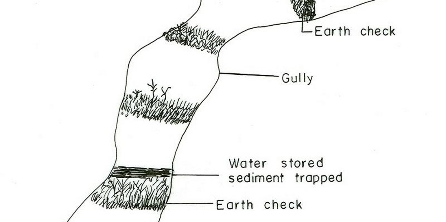
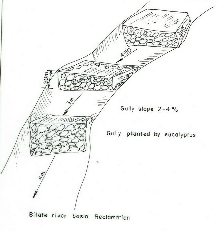
Active deep gullies are plugged by digging earth from the bottom as well as gully sides and embanked forming a barrier to runoff passing through it. The embankment is reinforced by planting useful plants such as banana, sesbania, gravillea, gesho, etc., The purpose is to rehabilitate gullies having depth and expand along sides and towards the head. By constructing earth checks the water is stored in the checks. The water percolates down the ground enriching the ground water. The soil is trapped in the checks and later brings up the gully gradient higher. As a result, a cultivable/cropable strip is formed. Weeding and cultivation done to plants established.The gully fence and breaks are repaired. The technology is seen to be suitable to humid highlands where land loss by gully is a serious problem and land under cultivation and grazing is getting here and there. In brief it is suitable in areas where land degradation problem is increasing with currently cultivated and grazed lands are encroched by gully expansion.

สถานที่

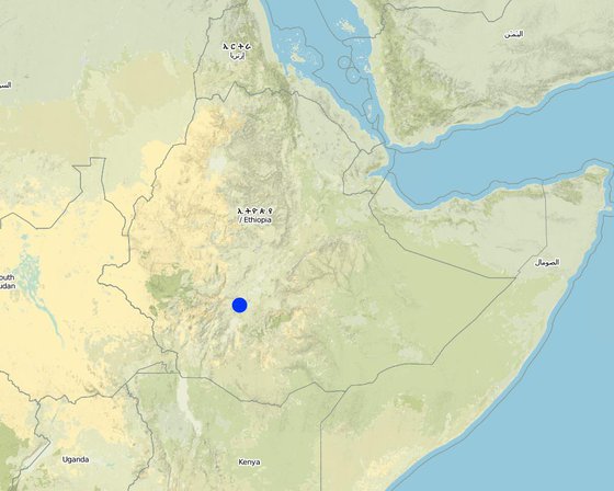
สถานที่: SNNPR/Damot Galle/Bilate, SNNPR, เอธิโอเปีย

ตำนวนการวิเคราะห์เทคโนโลยี:

ตำแหน่งทางภูมิศาสตร์ของสถานที่ที่ถูกเลือ
  • 38.09, 7.05

การเผยแพร่ของเทคโนโลยี:

In a permanently protected area?:

วันที่ในการดำเนินการ: น้อยกว่า 10 ปี (ไม่นานนี้)

ประเภทของการแนะนำ

การจำแนกประเภทเทคโนโลยี

จุดประสงค์หลัก
  • ปรับปรุงการผลิตให้ดีขึ้น
  • ลด ป้องกัน ฟื้นฟู การเสื่อมโทรมของที่ดิน
  • อนุรักษ์ระบบนิเวศน์
  • ป้องกันพื้นที่ลุ่มน้ำ/บริเวณท้ายน้ำ โดยร่วมกับเทคโนโลยีอื่นๆ
  • รักษาสภาพหรือปรับปรุงความหลากหลายทางชีวภาพ
  • ลดความเสี่ยงของภัยพิบัติ
  • ปรับตัวเข้ากับการเปลี่ยนแปลงภูมิอากาศของโลก สภาพภูมิอากาศที่รุนแรงและผลกระทบ
  • ชะลอการเปลี่ยนแปลงภูมิอากาศของโลกและผลกระทบ
  • สร้างผลกระทบทางด้านเศรษฐกิจที่เป็นประโยชน์
  • สร้างผลกระทบทางด้านสังคมที่เป็นประโยชน์
การใช้ที่ดิน
Land use mixed within the same land unit: ใช่ - การปลูกพืชร่วมกับปศุสัตว์และการทำป่าไม้ (Agro-silvopastoralism)

  • พื้นที่ปลูกพืช
    • การปลูกพืชล้มลุกอายุปีเดียว: cereals - maize, cereals - sorghum, root/tuber crops - sweet potatoes, yams, taro/cocoyam, other, root/tuber crops - cassava, root/tuber crops - potatoes
    • การปลูกพืชยืนต้นที่ไม่มีเนื้อไม้
    • การปลูกไม้ยืนต้น ไม้พุ่ม: avocado, fruits, other, mango, mangosteen, guava, papaya, enset, taro, sugar cane, Leucaena, Sesbania, Grevillea
    จำนวนของฤดูเพาะปลูกต่อปี: 2
    Is intercropping practiced? ใช่
    Is crop rotation practiced? ใช่
  • ทุ่งหญ้าเลี้ยงสัตว์
      Animal type: cattle - dairy, horses, donkeys, oxen
    • ป่า/พื้นที่ทำไม้ ผลิตภัณฑ์และบริการ: ไม้ซุง, ไม้ที่นำมาทำเป็นเชื้อเพลิง, การแทะเล็มหญ้า / การเก็บกินหญ้า
    การใช้น้ำ
    • จากน้ำฝน
    • น้ำฝนร่วมกับการชลประทาน
    • การชลประทานแบบเต็มรูปแบบ

    ความมุ่งหมายที่เกี่ยวข้องกับการเสื่อมโทรมของที่ดิน
    • ป้องกันความเสื่อมโทรมของที่ดิน
    • ลดความเสื่อมโทรมของดิน
    • ฟื้นฟูบำบัดที่ดินที่เสื่อมโทรมลงอย่างมาก
    • ปรับตัวกับสภาพความเสื่อมโทรมของที่ดิน
    • ไม่สามารถใช้ได้
    ที่อยู่ของการเสื่อมโทรม
    • การกัดกร่อนของดินโดยน้ำ - Wt (Loss of topsoil): การสูญเสียดินชั้นบนหรือการกัดกร่อนที่ผิวดิน , Wg (Gully erosion): การกัดกร่อนแบบร่องธารหรือการทำให้เกิดร่องน้ำเซาะ
    • การเสื่อมโทรมของดินทางด้านเคมี - Cn (Fertility decline): ความอุดมสมบูรณ์และปริมาณอินทรียวัตถุในดินถูกทำให้ลดลงไป (ไม่ได้เกิดจากสาเหตุการกัดกร่อน)
    กลุ่ม SLM
    • มาตรการปลูกพืชขวางความลาดชัน (cross-slope measure)
    • การเก็บเกี่ยวน้ำ
    มาตรการ SLM

    แบบแปลนทางเทคนิค

    ข้อมูลจำเพาะด้านเทคนิค
    SNNPR

    Technical knowledge required for field staff / advisors: high

    Technical knowledge required for land users: moderate

    Main technical functions: water harvesting / increase water supply, sediment retention / trapping, sediment harvesting

    Secondary technical functions: control of concentrated runoff: retain / trap, reduction of slope angle, reduction of slope length

    Early planting
    Material/ species: maize
    Quantity/ density: 85000/ha
    Remarks: sawn in lines

    Mixed cropping / intercropping
    Material/ species: maize-sweet potato/haricot bean
    Remarks: inter cropped & strip cropped

    Contour planting / strip cropping
    Material/ species: maize-taro-enset

    Mulching
    Material/ species: enset

    Manure / compost / residues
    Material/ species: maize, potato, sweet potato, traro

    Mineral (inorganic) fertilizers
    Material/ species: Teff, maize, sorghum

    Rotations / fallows
    Material/ species: maize-tarro-sorghum
    Remarks: only rotations

    Breaking compacted topsoil
    Remarks: primary and secondary oxen tillage

    Contour tillage
    Remarks: tillage done following contour

    Agronomic measure: harrowing

    Aligned: -contour
    Vegetative material: O : other
    Vertical interval between rows / strips / blocks (m): 0.2-0.5
    Spacing between rows / strips / blocks (m): 2-4
    Vertical interval within rows / strips / blocks (m): 0.5-2
    Width within rows / strips / blocks (m): 0.5-1

    Scattered / dispersed
    Vegetative material: T : trees / shrubs
    Number of plants per (ha): 4000
    Vertical interval between rows / strips / blocks (m): 0.2
    Spacing between rows / strips / blocks (m): 1.5x1.5
    Vertical interval within rows / strips / blocks (m): 1.5
    Width within rows / strips / blocks (m): 1.5

    In blocks
    Vegetative material: T : trees / shrubs
    Number of plants per (ha): 2500
    Vertical interval between rows / strips / blocks (m): 0.5
    Spacing between rows / strips / blocks (m): 2x2
    Vertical interval within rows / strips / blocks (m): 2
    Width within rows / strips / blocks (m): 2

    Trees/ shrubs species: Leucaena, Sesbania, Grevillea

    Fruit trees / shrubs species: Mango, papaya, Avocado

    Perennial crops species: Casava

    Slope (which determines the spacing indicated above): 10.00%

    If the original slope has changed as a result of the Technology, the slope today is (see figure below): 8.00%

    Gradient along the rows / strips: 0.00%

    Diversion ditch/ drainage
    Depth of ditches/pits/dams (m): 0.5
    Width of ditches/pits/dams (m): 0.5
    Length of ditches/pits/dams (m): 100
    Height of bunds/banks/others (m): 0.6
    Width of bunds/banks/others (m): 0.5
    Length of bunds/banks/others (m): 100

    Retention/infiltration ditch/pit, sediment/sand trap
    Vertical interval between structures (m): 0.5
    Depth of ditches/pits/dams (m): 0.6
    Width of ditches/pits/dams (m): 0.7
    Length of ditches/pits/dams (m): 4
    Height of bunds/banks/others (m): 0.75
    Width of bunds/banks/others (m): 0.6

    Terrace: backward sloping
    Vertical interval between structures (m): 1.5
    Spacing between structures (m): 12
    Depth of ditches/pits/dams (m): 0.9
    Width of ditches/pits/dams (m): 0.5
    Length of ditches/pits/dams (m): 50-75

    Bund/ bank: level
    Vertical interval between structures (m): 1.2
    Spacing between structures (m): 10
    Depth of ditches/pits/dams (m): 0.6
    Width of ditches/pits/dams (m): 0.7
    Length of ditches/pits/dams (m): 50-80
    Height of bunds/banks/others (m): 0.75

    Construction material (earth): Most of the structural measures are made by earth involving excavation and embankment.

    Construction material (stone): Stone is mainly used for demonstration.

    Slope (which determines the spacing indicated above): 10%

    If the original slope has changed as a result of the Technology, the slope today is: 8%

    Lateral gradient along the structure: 0%

    Vegetation is used for stabilisation of structures.

    Change of land use type: The land after treatment is closed

    Control / change of species composition: Grazing land changed to plantation and cropping

    Other type of management: change of management / intensity level - Grazing land changed to plantation and cropping

    การจัดตั้งและการบำรุงรักษา: กิจกรรม ปัจจัยและค่าใช้จ่าย

    การคำนวนต้นทุนและค่าใช้จ่าย
    • ค่าใช้จ่ายถูกคำนวน
    • สกุลเงินที่ใช้คำนวณค่าใช้จ่าย Birr
    • อัตราแลกเปลี่ยน (ไปเป็นดอลลาร์สหรัฐ) คือ 1 ดอลลาร์สหรัฐ = 8.5 Birr
    • ค่าจ้างเฉลี่ยในการจ้างแรงงานต่อวันคือ 0.60
    ปัจจัยที่สำคัญที่สุดที่มีผลต่อค่าใช้จ่าย
    Factors affecting costs in this technology are the depth and width of gully, steepness of slope, planting and replanting of vegetative materials.
    กิจกรรมเพื่อการจัดตั้ง
    1. Land preparation (ช่วงระยะเวลา/ความถี่: September, october)
    2. Sugar cane planting (ช่วงระยะเวลา/ความถี่: November)
    3. Sugar cane cultivation (ช่วงระยะเวลา/ความถี่: January/August)
    4. Casava planting (ช่วงระยะเวลา/ความถี่: April)
    5. Casava cultivation (ช่วงระยะเวลา/ความถี่: June)
    6. Maize planting (ช่วงระยะเวลา/ความถี่: January-1st plough, April 2nd plough)
    7. Maize cultivation (ช่วงระยะเวลา/ความถี่: June)
    8. Sweet potato planting (ช่วงระยะเวลา/ความถี่: September)
    9. Sweet potato cultivation (ช่วงระยะเวลา/ความถี่: October)
    10. Fruite trees (ช่วงระยะเวลา/ความถี่: June)
    11. Digging foundation (ช่วงระยะเวลา/ความถี่: November-February)
    12. Forming embankment (ช่วงระยะเวลา/ความถี่: November-February)
    13. Side wall shaping (ช่วงระยะเวลา/ความถี่: November-February)
    14. Planting trees and shrubs (ช่วงระยะเวลา/ความถี่: March-1st planting & June 2nd planting)
    15. Excluding animals by fencing and guarding (ช่วงระยะเวลา/ความถี่: all year)
    16. Construct cutoff drain (ช่วงระยะเวลา/ความถี่: dry season)
    17. Establish buffer zone between Area enclosure and crop land by strip of plantation (ช่วงระยะเวลา/ความถี่: June/July)
    18. Construct earth checks and trenches in the gully (ช่วงระยะเวลา/ความถี่: dry season)
    ปัจจัยและค่าใช้จ่ายของการจัดตั้ง
    ปัจจัยนำเข้า หน่วย ปริมาณ ค่าใช้จ่ายต่อหน่วย (Birr) ค่าใช้จ่ายทั้งหมดต่อปัจจัยนำเข้า (Birr) %ของค่าใช้จ่ายที่ก่อให้เกิดขึ้นโดยผู้ใช้ที่ดิน
    แรงงาน
    Labour ha 1.0 282.3 282.3 100.0
    อุปกรณ์
    Tools ha 1.0 270.6 270.6 100.0
    วัสดุด้านพืช
    Seedlings ha 1.0 117.6 117.6 100.0
    ค่าใช้จ่ายทั้งหมดของการจัดตั้งเทคโนโลยี 670.5
    Total costs for establishment of the Technology in USD 78.88
    กิจกรรมสำหรับการบำรุงรักษา
    1. Land preparation (ช่วงระยะเวลา/ความถี่: september, october / 2 times)
    2. Sweet potato planting (ช่วงระยะเวลา/ความถี่: September / each cropping season)
    3. Sweet potato cultivation (ช่วงระยะเวลา/ความถี่: October / each cropping season)
    4. Maize planting (ช่วงระยะเวลา/ความถี่: January/April / each cropping season)
    5. Maize cultivation (ช่วงระยะเวลา/ความถี่: June / each cropping season)
    6. Teff sawing (ช่วงระยะเวลา/ความถี่: None)
    7. Teff weeding (ช่วงระยะเวลา/ความถี่: None)
    8. Prunning (ช่วงระยะเวลา/ความถี่: october /once)
    9. Mulching (ช่วงระยะเวลา/ความถี่: october /once)
    10. Thining (ช่วงระยะเวลา/ความถี่: october /once)
    11. Fencing (ช่วงระยะเวลา/ความถี่: any time /once)
    12. Weeding (ช่วงระยะเวลา/ความถี่: June/each cropping season)
    13. Cultivation (ช่วงระยะเวลา/ความถี่: March/each cropping season)
    14. Replanting (ช่วงระยะเวลา/ความถี่: June/each cropping season)
    15. Repair in breaks (ช่วงระยะเวลา/ความถี่: November-February/each cropping season)
    16. Fence (ช่วงระยะเวลา/ความถี่: each cropping season)
    17. Repair breaks on cutoff drain and earth checks (ช่วงระยะเวลา/ความถี่: dry season / 2 years)
    18. Prunning, weeding and cultivation (ช่วงระยะเวลา/ความถี่: end of rains / each cropping season)

    สิ่งแวดล้อมทางธรรมชาติ

    ปริมาณน้ำฝนเฉลี่ยรายปี
    • < 250 ม.ม.
    • 251-500 ม.ม.
    • 501-750 ม.ม.
    • 751-1,000 ม.ม.
    • 1,001-1,500 ม.ม.
    • 1,501-2,000 ม.ม.
    • 2,001-3,000 ม.ม.
    • 3,001-4,000 ม.ม.
    • > 4,000 ม.ม.
    เขตภูมิอากาศเกษตร
    • ชื้น
    • กึ่งชุ่มชื้น
    • กึ่งแห้งแล้ง
    • แห้งแล้ง
    ข้อมูลจำเพาะเรื่องภูมิอากาศ
    n.a.
    ความชัน
    • ราบเรียบ (0-2%)
    • ลาดที่ไม่ชัน (3-5%)
    • ปานกลาง (6-10%)
    • เป็นลูกคลื่น (11-15%)
    • เป็นเนิน (16-30%)
    • ชัน (31-60%)
    • ชันมาก (>60%)
    ภูมิลักษณ์
    • ที่ราบสูง/ที่ราบ
    • สันเขา
    • ไหล่เขา
    • ไหล่เนินเขา
    • ตีนเนิน
    • หุบเขา
    ความสูง
    • 0-100 เมตร
    • 101-500 เมตร
    • 501-1,000 เมตร
    • 1,001-1,500 เมตร
    • 1,501-2,000 เมตร
    • 2,001-2,500 เมตร
    • 2,501-3,000 เมตร
    • 3,001-4,000 เมตร
    • > 4,000 เมตร
    เทคโนโลยีถูกประยุกต์ใช้ใน
    • บริเวณสันเขา (convex situations)
    • บริเวณแอ่งบนที่ราบ (concave situations)
    • ไม่เกี่ยวข้อง
    ความลึกของดิน
    • ตื้นมาก (0-20 ซ.ม.)
    • ตื้น (21-50 ซ.ม.)
    • ลึกปานกลาง (51-80 ซ.ม.)
    • ลึก (81-120 ซ.ม.)
    • ลึกมาก (>120 ซ.ม.)
    เนื้อดิน (ดินชั้นบน)
    • หยาบ/เบา (ดินทราย)
    • ปานกลาง (ดินร่วน ทรายแป้ง)
    • ละเอียด/หนัก (ดินเหนียว)
    เนื้อดิน (> 20 ซม. ต่ำกว่าพื้นผิว)
    • หยาบ/เบา (ดินทราย)
    • ปานกลาง (ดินร่วน ทรายแป้ง)
    • ละเอียด/หนัก (ดินเหนียว)
    สารอินทรียวัตถุในดิน
    • สูง (>3%)
    • ปานกลาง (1-3%)
    • ต่ำ (<1%)
    น้ำบาดาล
    • ที่ผิวดิน
    • <5 เมตร
    • 5-50 เมตร
    • > 50 เมตร
    ระดับน้ำบาดาลที่ผิวดิน
    • เกินพอ
    • ดี
    • ปานกลาง
    • ไม่ดีหรือไม่มีเลย
    คุณภาพน้ำ (ยังไม่ได้รับการบำบัด)
    • เป็นน้ำเพื่อการดื่มที่ดี
    • เป็นน้ำเพื่อการดื่มที่ไม่ดี (จำเป็นต้องได้รับการบำบัด)
    • เป็นน้ำใช้เพื่อการเกษตรเท่านั้น (การชลประทาน)
    • ใช้ประโยชน์ไม่ได้
    ความเค็มของน้ำเป็นปัญหาหรือไม่?
    • ใช่
    • ไม่ใช่

    การเกิดน้ำท่วม
    • ใช่
    • ไม่ใช่
    ความหลากหลายทางชนิดพันธุ์
    • สูง
    • ปานกลาง
    • ต่ำ
    ความหลากหลายของแหล่งที่อยู่
    • สูง
    • ปานกลาง
    • ต่ำ

    ลักษณะเฉพาะของผู้ใช้ที่ดินที่ประยุกต์ใช้เทคโนโลยี

    เป้าหมายทางการตลาด
    • เพื่อการยังชีพ (หาเลี้ยงตนเอง)
    • mixed (subsistence/ commercial)
    • ทำการค้า/การตลาด
    รายได้จากภายนอกฟาร์ม
    • < 10% ของรายได้ทั้งหมด
    • 10-50% ของรายได้ทั้งหมด
    • > 50% ของรายได้ทั้งหมด
    ระดับของความมั่งคั่งโดยเปรียบเทียบ
    • ยากจนมาก
    • จน
    • พอมีพอกิน
    • รวย
    • รวยมาก
    ระดับของการใช้เครื่องจักรกล
    • งานที่ใช้แรงกาย
    • การใช้กำลังจากสัตว์
    • การใช้เครื่องจักรหรือเครื่องยนต์
    อยู่กับที่หรือเร่ร่อน
    • อยู่กับที่
    • กึ่งเร่ร่อน
    • เร่ร่อน
    เป็นรายบุคคลหรือกลุ่ม
    • เป็นรายบุคคล/ครัวเรือน
    • กลุ่ม/ชุมชน
    • สหกรณ์
    • ลูกจ้าง (บริษัท รัฐบาล)
    เพศ
    • หญิง
    • ชาย
    อายุ
    • เด็ก
    • ผู้เยาว์
    • วัยกลางคน
    • ผู้สูงอายุ
    พื้นที่ที่ใช้ต่อครัวเรือน
    • < 0.5 เฮกตาร์
    • 0.5-1 เฮกตาร์
    • 1-2 เฮกตาร์
    • 2-5 เฮกตาร์
    • 5-15 เฮกตาร์
    • 15-50 เฮกตาร์
    • 50-100 เฮกตาร์
    • 100-500 เฮกตาร์
    • 500-1,000 เฮกตาร์
    • 1,000-10,000 เฮกตาร์
    • >10,000 เฮกตาร์
    ขนาด
    • ขนาดเล็ก
    • ขนาดกลาง
    • ขนาดใหญ่
    กรรมสิทธิ์ในที่ดิน
    • รัฐ
    • บริษัท
    • เป็นแบบชุมชนหรือหมู่บ้าน
    • กลุ่ม
    • รายบุคคล ไม่ได้รับสิทธิครอบครอง
    • รายบุคคล ได้รับสิทธิครอบครอง
    สิทธิในการใช้ที่ดิน
    • เข้าถึงได้แบบเปิด (ไม่ได้จัดระเบียบ)
    • เกี่ยวกับชุมชน (ถูกจัดระเบียบ)
    • เช่า
    • รายบุคคล
    สิทธิในการใช้น้ำ
    • เข้าถึงได้แบบเปิด (ไม่ได้จัดระเบียบ)
    • เกี่ยวกับชุมชน (ถูกจัดระเบียบ)
    • เช่า
    • รายบุคคล
    เข้าถึงการบริการและโครงสร้างพื้นฐาน

    ผลกระทบ

    ผลกระทบทางด้านเศรษฐกิจและสังคม
    การผลิตพืชผล
    ลดลง
    x
    เพิ่มขึ้น

    การผลิตพืชที่ใช้เลี้ยงปศุสัตว์
    ลดลง
    x
    เพิ่มขึ้น

    คุณภาพพืชที่ใช้เลี้ยงปศุสัตว์
    ลดลง
    x
    เพิ่มขึ้น

    พื้นที่สำหรับการผลิต (ที่ดินใหม่ที่อยู่ในระหว่างเพาะปลูกหรือใช้งาน)
    ลดลง
    x
    เพิ่มขึ้น


    Shortage of grazing land: Animals are thethered in a small plots

    รายได้จากฟาร์ม
    ลดลง
    x
    เพิ่มขึ้น

    ผลกระทบด้านสังคมและวัฒนธรรม
    สถาบันของชุมชน
    อ่อนแอลง
    x
    เสริมให้แข็งแรง


    teams are formed

    สถาบันแห่งชาติ
    อ่อนแอลง
    x
    เสริมให้แข็งแรง

    SLM หรือความรู้เรื่องความเสื่อมโทรมของที่ดิน
    ลดลง
    x
    ปรับปรุงดีขึ้น

    การบรรเทาความขัดแย้ง
    แย่ลง
    x
    ปรับปรุงดีขึ้น


    many wants to be beneficiaries but only the poor given the opportunities

    ผลกระทบด้านนิเวศวิทยา
    ความชื้นในดิน
    ลดลง
    x
    เพิ่มขึ้น

    สิ่งปกคลุมดิน
    ลดลง
    x
    ปรับปรุงดีขึ้น

    การสูญเสียดิน
    เพิ่มขึ้น
    x
    ลดลง

    Biodiversity enhancement
    decreased
    x
    increased

    ผลกระทบนอกพื้นที่ดำเนินการ
    น้ำท่วมพื้นที่ท้ายน้ำ (ที่ไม่เป็นที่ต้องการ)
    เพิ่มขึ้น
    x
    ลดลง


    all runoff retained

    การทับถมของดินตะกอนพื้นที่ท้ายน้ำ
    เพิ่มขึ้น
    x
    ลดลง


    all soil trapped

    รายได้และค่าใช้จ่าย

    ผลประโยชน์ที่ได้รับเปรียบเทียบกับค่าใช้จ่าย
    ผลตอบแทนระยะสั้น
    ด้านลบอย่างมาก
    x
    ด้านบวกอย่างมาก

    ผลตอบแทนระยะยาว
    ด้านลบอย่างมาก
    x
    ด้านบวกอย่างมาก

    ผลประโยชน์ที่ได้รับเปรียบเทียบกับค่าใช้จ่ายในการบำรุงรักษา
    ผลตอบแทนระยะสั้น
    ด้านลบอย่างมาก
    x
    ด้านบวกอย่างมาก

    ผลตอบแทนระยะยาว
    ด้านลบอย่างมาก
    x
    ด้านบวกอย่างมาก

    การเปลี่ยนแปลงของสภาพภูมิอากาศ

    -

    การน้อมเอาความรู้และการปรับใช้

    เปอร์เซ็นต์ของผู้ใช้ที่ดินในพื้นที่ที่นำเทคโนโลยีไปใช้
    • ครั้งเดียวหรือเป็นการทดลอง
    • 1-10%
    • 11-50%
    • > 50%
    จากทั้งหมดที่ได้รับเทคโนโลยีเข้ามามีจำนวนเท่าใดที่ทำแบบทันที โดยไม่ได้รับการจูงใจด้านวัสดุหรือการเงินใดๆ?
    • 0-10%
    • 11-50%
    • 51-90%
    • 91-100%
    เทคโนโลยีได้รับการปรับเปลี่ยนเร็วๆ นี้เพื่อให้ปรับตัวเข้ากับสภาพที่กำลังเปลี่ยนแปลงหรือไม่?
    • ใช่
    • ไม่ใช่
    สภาพที่กำลังเปลี่ยนแปลงอันไหน?
    • การเปลี่ยนแปลงแบบค่อยเป็นค่อยไปและสภาพรุนแรงของภูมิอากาศ
    • การเปลี่ยนแปลงของตลาด
    • การมีแรงงานไว้ให้ใช้ (เนื่องจากการอพยพย้ายถิ่นฐาน)

    บทสรุปหรือบทเรียนที่ได้รับ

    จุดแข็ง: มุมมองของผู้ใช้ที่ดิน
    จุดแข็ง: ทัศนคติของผู้รวบรวมหรือวิทยากรคนอื่นๆ
    จุดด้อย/ข้อเสีย/ความเสี่ยง: มุมมองของผู้ใช้ที่ดินแก้ไขปัญหาได้อย่างไร
    จุดด้อย/ข้อเสีย/ความเสี่ยง: ทัศนคติของผู้รวบรวมหรือวิทยากรคนอื่นๆแก้ไขปัญหาได้อย่างไร

    การอ้างอิง

    ผู้รวบรวม
    • Daniel Danano
    Editors
    ผู้ตรวจสอบ
    • Fabian Ottiger
    • Alexandra Gavilano
    วันที่จัดทำเอกสาร: 30 พฤษภาคม 2011
    การอัพเดทล่าสุด: 9 กันยายน 2019
    วิทยากร
    คำอธิบายฉบับเต็มในฐานข้อมูล WOCAT
    ข้อมูล SLM ที่ถูกอ้างอิง
    การจัดทำเอกสารถูกทำโดย
    องค์กร โครงการ
    This work is licensed under Creative Commons Attribution-NonCommercial-ShareaAlike 4.0 International