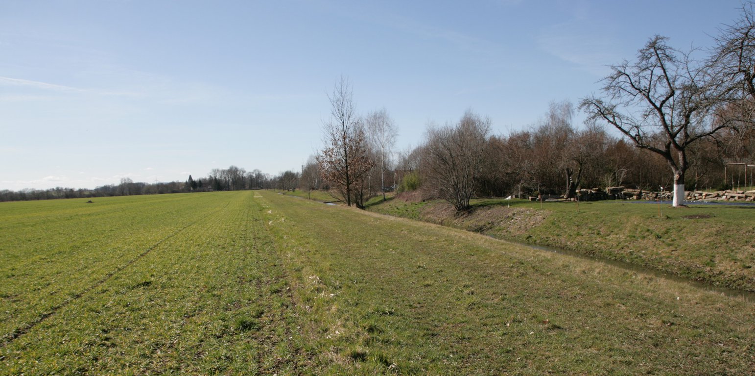
Riparian buffer strip with naturally recovered vegetation (Felix Witing)
Riparian buffer strips comprise permanent, protective vegetation alongside streams and other water bodies. Our example represents a riparian buffer that evolved from set-aside land with naturally recovered vegetation. For the farmer, this has several advantages in terms of implementation, maintenance and seed costs. The farmer was able to simply leave the buffer strip open after ploughing without seeding or rolling, and maintenance requires only one mowing operation per year.
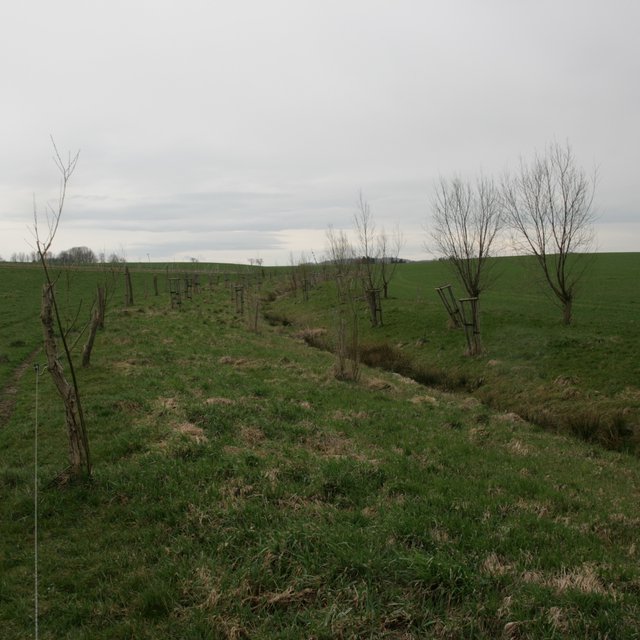
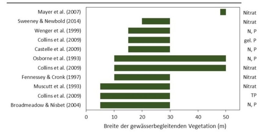
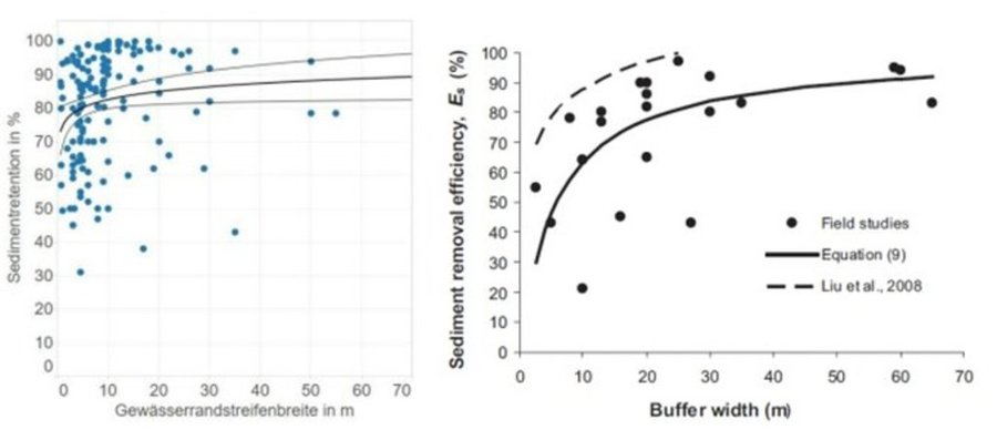
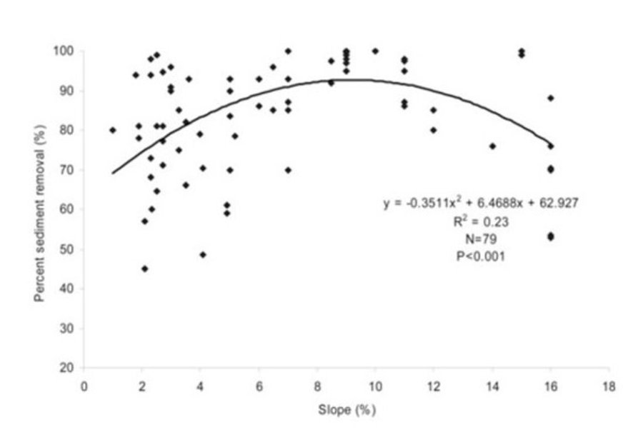
Riparian buffer strips are established at the edge of cultivated areas adjacent to water bodies. The width of the strip should be 5-15 m. In our example, the width of the buffer strip was 6 m, which was defined by working width of the mower. Depending on the type and width of the buffer, the rainfall intensity, the slope and the management, different filtering capacities can be attained by a buffer. An effective strip can retain 70% of the sediment and reduce nutrients in the surface runoff by 50%. However efficient retention of nutrients requires a buffer width of at least 15 m, while efficient retention of fine sediments requires a width of 15-20 m. The slope of the watercourse bank is also important: the optimum slope is 9-10%, and retention performance worsens with increasing slope (Kail et al. 2022).
Grass cover roughens the soil surface, slowing down the flow of water after heavy rainfall events and improving infiltration rates. Additionally, the roots of grasses increase infiltration, the plants absorb nitrate and prevent it from running off into the water bodies. Deeper roots, such as those from trees stabilize river banks, preventing bank erosion during heavy rainfall, as well as increasing shading of the stream. This improves the microclimate and creates better habitats for species native to the watercourse. Moreover, the buffer reduces the siltation of water bodies, preserves gravel bars, and thus preserves habitats. The buffer strip itself provides habitats for flora and fauna. The area adjacent to the buffer strip may experience increased dew formation and soil moisture, reduced evaporation, and wind protection.
The surface roughness of the grassed buffer strip depends on the type of vegetation. Cold-tolerant grasses such as perennial ryegrass (Lolium perenne) are commonly used, but a mix of grasses and trees is even better. Grassland provides an evenly distributed surface cover and the trees, with their deeper roots, provider higher infiltration capacity. Fast growing, low maintenance and regional species are optimal.
Proper maintenance is important for permanent erosion control. In case of nutrient-rich runoff from adjacent fields, the buffer strip may become saturated after a while and nitrification increases. Nitrous oxide is then produced which is a powerful greenhouse gases. In addition, the soil/vegetation is no longer able to absorb new nutrients, and they are washed into the water body. Mowing once per year removes biomass and can prevent nutrient saturation (Cole et al. 2020).
However, while promoting biodiversity and reducing soil erosion, buffer strips have a major downside for land-users and land-owners. They consume cropland, which leads to a decrease in production. The grass mixture can be used as fodder, but usually this does not compensate for the loss of production, which is why farmers often call for appropriate subsidies.
สถานที่: Nieder Seifersdorf, Saxony, เยอรมนี
ตำนวนการวิเคราะห์เทคโนโลยี: พื้นที่เดี่ยว
การเผยแพร่ของเทคโนโลยี: ใช้ ณ จุดที่เฉพาะเจาะจงหรือเน้นไปยังบริเวณพื้นที่ขนาดเล็ก
In a permanently protected area?: ไม่ใช่
วันที่ในการดำเนินการ: 2013
ประเภทของการแนะนำ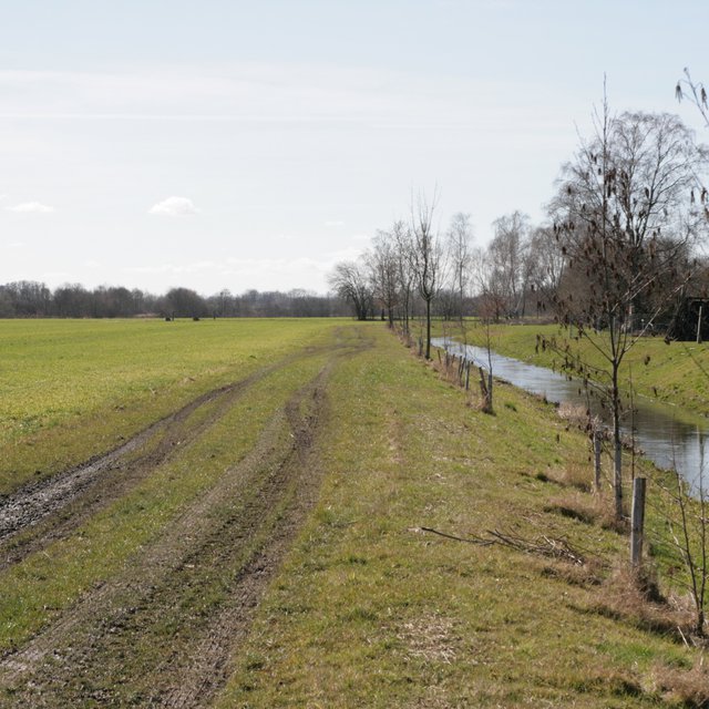


| ปัจจัยนำเข้า | หน่วย | ปริมาณ | ค่าใช้จ่ายต่อหน่วย (€) | ค่าใช้จ่ายทั้งหมดต่อปัจจัยนำเข้า (€) | %ของค่าใช้จ่ายที่ก่อให้เกิดขึ้นโดยผู้ใช้ที่ดิน |
| แรงงาน | |||||
| mowing | ha | 1.0 | 25.0 | 25.0 | |
| ค่าใช้จ่ายทั้งหมดของการบำรุงรักษาสภาพเทคโนโลยี | 25.0 | ||||
| Total costs for maintenance of the Technology in USD | 27.47 | ||||
decreased wind erosion


