
Riparian buffer strip with naturally recovered vegetation [เยอรมนี]
- ผู้สร้างสรรค์:
- การอัพเดท:
- ผู้รวบรวม: Felix Witing
- ผู้เรียบเรียง: Michael Strauch, Mona Pauer
- ผู้ตรวจสอบ: William Critchley, Rima Mekdaschi Studer
Selbstbegrünte Brache als Gewässerrandstreifen
technologies_6258 - เยอรมนี
ดูส่วนย่อย
ขยายทั้งหมด ย่อทั้งหมด1. ข้อมูลทั่วไป
1.2 รายละเอียดที่ติดต่อได้ของผู้รวบรวมและองค์กรที่เกี่ยวข้องในการประเมินและการจัดเตรียมทำเอกสารของเทคโนโลยี
ผู้เชี่ยวชาญ SLM:
ผู้เชี่ยวชาญ SLM:
ชื่อของโครงการซึ่งอำนวยความสะดวกในการทำเอกสารหรือการประเมินเทคโนโลยี (ถ้าเกี่ยวข้อง)
OPtimal strategies to retAIN and re-use water and nutrients in small agricultural catchments across different soil-climatic regions in Europe (OPTAIN)ชื่อขององค์กรซึ่งอำนวยความสะดวกในการทำเอกสารหรือการประเมินเทคโนโลยี (ถ้าเกี่ยวข้อง)
Helmholtz Centre for Environmental Research (UFZ) - เยอรมนี1.3 เงื่อนไขการใช้ข้อมูลที่ได้บันทึกผ่านทาง WOCAT
ผู้รวบรวมและวิทยากรหลักยอมรับเงื่อนไขเกี่ยวกับการใช้ข้อมูลที่ถูกบันทึกผ่านทาง WOCAT:
ใช่
1.4 การเปิดเผยเรื่องความยั่งยืนของเทคโนโลยีที่ได้อธิบายไว้
เทคโนโลยีที่ได้อธิบายไว้นี้เป็นปัญหาของความเสื่อมโทรมโทรมของที่ดินหรือไม่ จึงไม่ได้รับการยอมรับว่าเป็นเทคโนโลยีเพื่อการจัดการที่ดินอย่างยั่งยืน:
ไม่ใช่
2. การอธิบายลักษณะของเทคโนโลยี SLM
2.1 การอธิบายแบบสั้น ๆ ของเทคโนโลยี
คำจำกัดความของเทคโนโลยี:
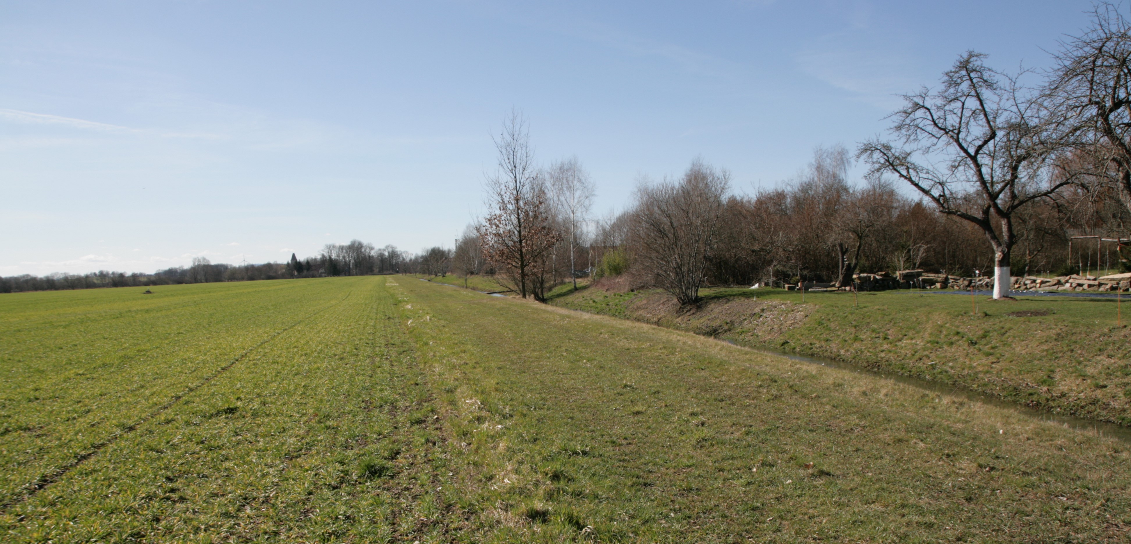
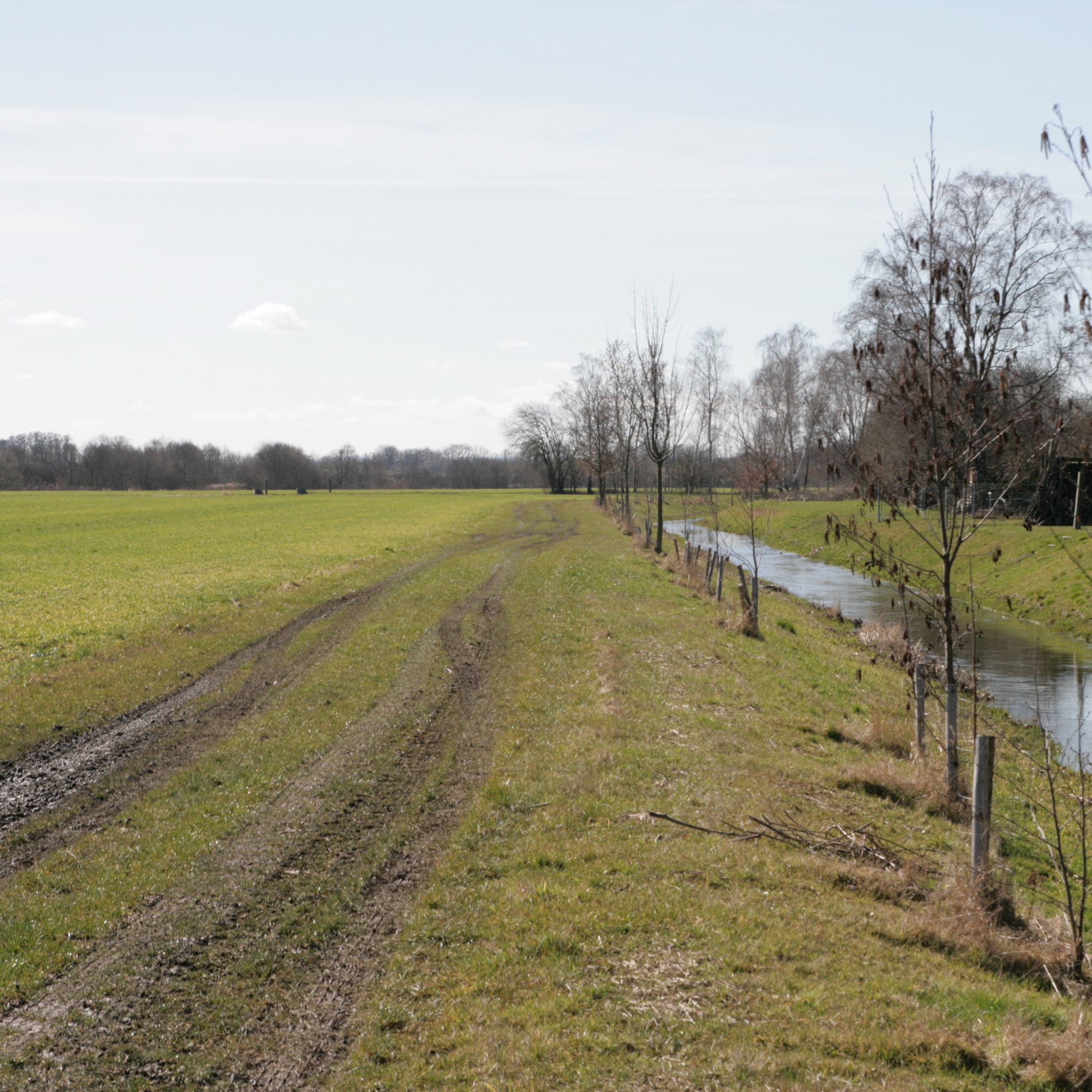
Riparian buffer strips refer to the permanent greening of arable land alongside streams and other water bodies. By slowing down runoff water from the land, they help to protect water bodies from diffuse pollution. Riparian buffer strips have multiple other environmental benefits, but disadvantages also.
2.2 การอธิบายแบบละเอียดของเทคโนโลยี
คำอธิบาย:
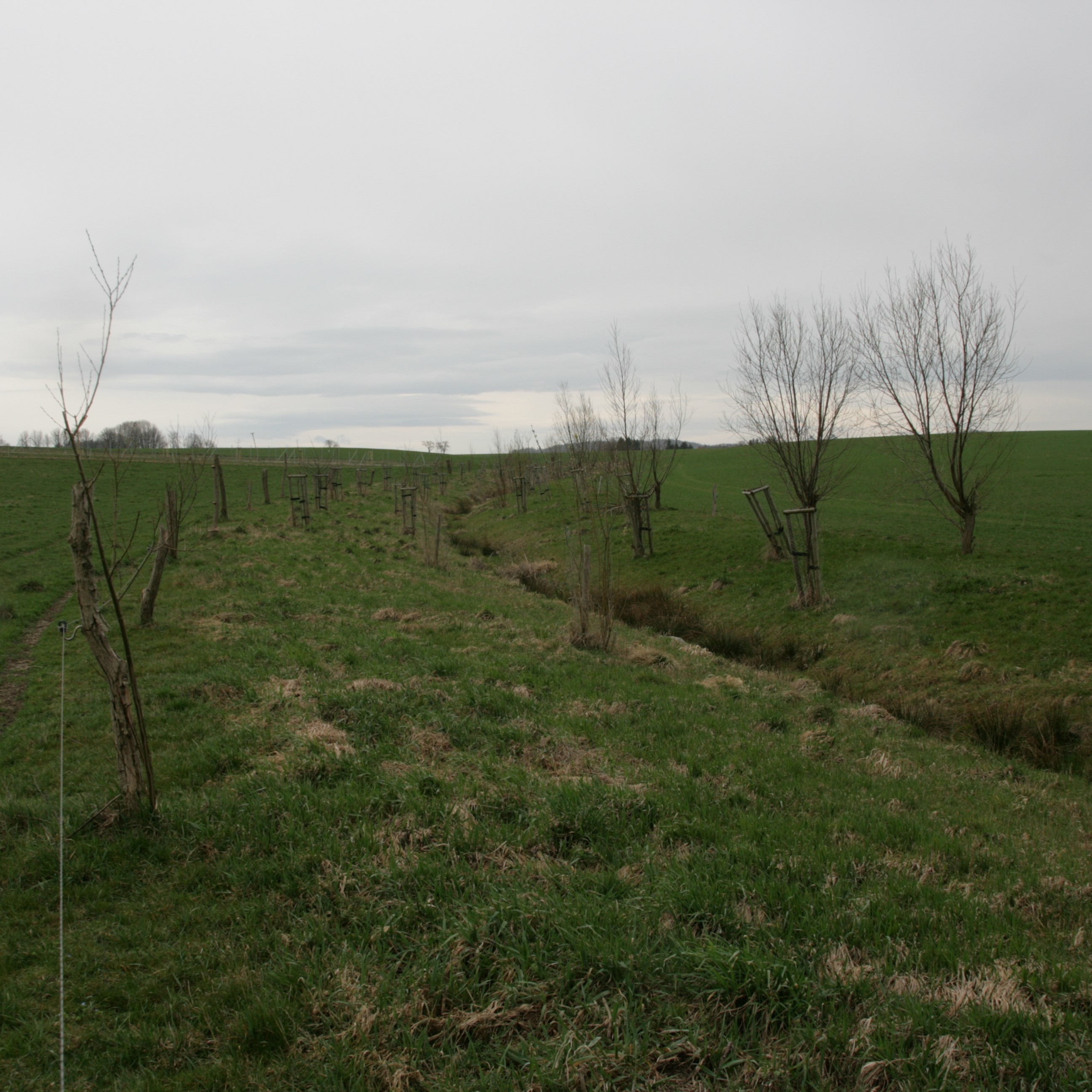
Riparian buffer strips comprise permanent, protective vegetation alongside streams and other water bodies. Our example represents a riparian buffer that evolved from set-aside land with naturally recovered vegetation. For the farmer, this has several advantages in terms of implementation, maintenance and seed costs. The farmer was able to simply leave the buffer strip open after ploughing without seeding or rolling, and maintenance requires only one mowing operation per year.
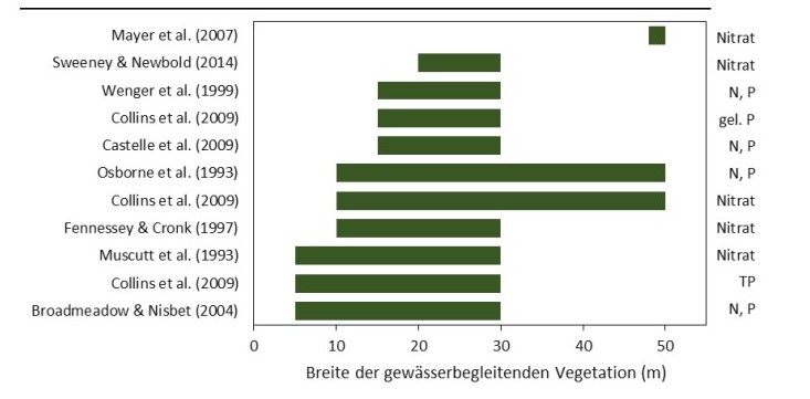
Riparian buffer strips are established at the edge of cultivated areas adjacent to water bodies. The width of the strip should be 5-15 m. In our example, the width of the buffer strip was 6 m, which was defined by working width of the mower. Depending on the type and width of the buffer, the rainfall intensity, the slope and the management, different filtering capacities can be attained by a buffer. An effective strip can retain 70% of the sediment and reduce nutrients in the surface runoff by 50%. However efficient retention of nutrients requires a buffer width of at least 15 m, while efficient retention of fine sediments requires a width of 15-20 m. The slope of the watercourse bank is also important: the optimum slope is 9-10%, and retention performance worsens with increasing slope (Kail et al. 2022).
Grass cover roughens the soil surface, slowing down the flow of water after heavy rainfall events and improving infiltration rates. Additionally, the roots of grasses increase infiltration, the plants absorb nitrate and prevent it from running off into the water bodies. Deeper roots, such as those from trees stabilize river banks, preventing bank erosion during heavy rainfall, as well as increasing shading of the stream. This improves the microclimate and creates better habitats for species native to the watercourse. Moreover, the buffer reduces the siltation of water bodies, preserves gravel bars, and thus preserves habitats. The buffer strip itself provides habitats for flora and fauna. The area adjacent to the buffer strip may experience increased dew formation and soil moisture, reduced evaporation, and wind protection.
The surface roughness of the grassed buffer strip depends on the type of vegetation. Cold-tolerant grasses such as perennial ryegrass (Lolium perenne) are commonly used, but a mix of grasses and trees is even better. Grassland provides an evenly distributed surface cover and the trees, with their deeper roots, provider higher infiltration capacity. Fast growing, low maintenance and regional species are optimal.
Proper maintenance is important for permanent erosion control. In case of nutrient-rich runoff from adjacent fields, the buffer strip may become saturated after a while and nitrification increases. Nitrous oxide is then produced which is a powerful greenhouse gases. In addition, the soil/vegetation is no longer able to absorb new nutrients, and they are washed into the water body. Mowing once per year removes biomass and can prevent nutrient saturation (Cole et al. 2020).
However, while promoting biodiversity and reducing soil erosion, buffer strips have a major downside for land-users and land-owners. They consume cropland, which leads to a decrease in production. The grass mixture can be used as fodder, but usually this does not compensate for the loss of production, which is why farmers often call for appropriate subsidies.
2.3 รูปภาพของเทคโนโลยี
อัลบั้มสื่อบันทึก
2.5 ประเทศภูมิภาค หรือสถานที่ตั้งที่เทคโนโลยีได้นำไปใช้และได้รับการครอบคลุมโดยการประเมินนี้
ประเทศ:
เยอรมนี
ภูมิภาค/รัฐ/จังหวัด:
Saxony
ข้อมูลจำเพาะเพิ่มเติมของสถานที่ตั้ง :
Nieder Seifersdorf
ระบุการกระจายตัวของเทคโนโลยี:
- ใช้ ณ จุดที่เฉพาะเจาะจงหรือเน้นไปยังบริเวณพื้นที่ขนาดเล็ก
Is/are the technology site(s) located in a permanently protected area?
ไม่ใช่
Map
×2.6 วันที่การดำเนินการ
ระบุปีที่ใช้:
2013
2.7 คำแนะนำของเทคโนโลยี
ให้ระบุว่าเทคโนโลยีถูกแนะนำเข้ามาอย่างไร:
- ทางโครงการหรือจากภายนอก
ความคิดเห็น (ประเภทของโครงการ เป็นต้น) :
In order to meet the greening requirements of the CAP, 4% of the total agricultural area of a farm must be used, for example, for crop diversification, maintenance of permanent grassland or creation of ecological priority areas in order to receive direct payments from the state. In this case, a self-vegetated fallow was established as an ecological priority area to fulfill the greening requirements.
3. การจัดประเภทของเทคโนโลยี SLM
3.1 วัตถุประสงค์หลักของเทคโนโลยี
- ลด ป้องกัน ฟื้นฟู การเสื่อมโทรมของที่ดิน
- อนุรักษ์ระบบนิเวศน์
- ป้องกันพื้นที่ลุ่มน้ำ/บริเวณท้ายน้ำ โดยร่วมกับเทคโนโลยีอื่นๆ
- รักษาสภาพหรือปรับปรุงความหลากหลายทางชีวภาพ
3.2 ประเภทของการใช้ที่ดินในปัจจุบันที่ได้นำเทคโนโลยีไปใช้
Land use mixed within the same land unit:
ไม่ใช่

ที่ดินที่ไม่ให้ผลผลิต
ระบุ:
self-vegetated fallow
ข้อสังเกต:
maintenance activity: mowing
3.3 Has land use changed due to the implementation of the Technology?
Has land use changed due to the implementation of the Technology?
- Yes (Please fill out the questions below with regard to the land use before implementation of the Technology)
Land use mixed within the same land unit:
ไม่ใช่

พื้นที่ปลูกพืช
- การปลูกพืชล้มลุกอายุปีเดียว
Annual cropping - Specify crops:
- cereals - barley
- cereals - maize
- cereals - rye
- cereals - wheat (winter)
Is intercropping practiced?
ไม่ใช่
Is crop rotation practiced?
ใช่
ถ้าใช่ ระบุ:
winter rye, winter wheat, silage maize, winter wheat, winter rye, winter barley, silage maize, winter barley, winter rye
3.4 การใช้น้ำ
การใช้น้ำของที่ดินที่มีการใช้เทคโนโลยีอยู่:
- จากน้ำฝน
3.5 กลุ่ม SLM ที่ตรงกับเทคโนโลยีนี้
- การปิดล้อมพื้นที่ (หยุดการใช้ประโยชน์ สนับสนุนการฟื้นฟู)
- การปรับปรุงดิน / พืชคลุมดิน
- มาตรการปลูกพืชขวางความลาดชัน (cross-slope measure)
3.6 มาตรการ SLM ที่ประกอบกันเป็นเทคโนโลยี

มาตรการอนุรักษ์ด้วยวิธีพืช
- V2: หญ้าและไม้ยืนต้น
3.7 รูปแบบหลักของการเสื่อมโทรมของที่ดินที่ได้รับการแก้ไขโดยเทคโนโลยี

การกัดกร่อนของดินโดยน้ำ
- Wt (Loss of topsoil): การสูญเสียดินชั้นบนหรือการกัดกร่อนที่ผิวดิน
- Wg (Gully erosion): การกัดกร่อนแบบร่องธารหรือการทำให้เกิดร่องน้ำเซาะ
- Wr (Riverbank erosion): การกัดกร่อนริมฝั่งแม่น้ำ
- Wo (Offsite degradation): ผลกระทบนอกพื้นที่

การเสื่อมโทรมของดินทางด้านเคมี
- Cn (Fertility decline): ความอุดมสมบูรณ์และปริมาณอินทรียวัตถุในดินถูกทำให้ลดลงไป (ไม่ได้เกิดจากสาเหตุการกัดกร่อน)

การเสื่อมโทรมของดินทางด้านกายภาพ
- Pc (Compaction): การอัดแน่น
- Pk (Slaking and crusting): การอุดตันของช่องว่างในดินหรือรูพรุน
- Pw (Waterlogging): ภาวะชุ่มน้ำ

การเสื่อมโทรมของดินทางด้านชีวภาพ
- Bc (Reduction of vegetation cover): การลดลงของจำนวนพืชที่ปกคลุมดิน
- Bh (Loss of habitat): การสูญเสียแหล่งที่อยู่
- Bs (Quality and species composition): องค์ประกอบหรือความหลากหลายทางคุณภาพและชนิดพันธุ์ลดลง
- Bl (Loss of soil life): การสูญเสียสิ่งมีชีวิตในดิน

การเสื่อมโทรมของน้ำ
- Hp (Decline of surface water quality): การลดลงของคุณภาพน้ำที่ผิวดิน
- Hq (Decline of groundwater quality): การลดลงของคุณภาพน้ำบาดาล
- Hw (Reduction of the buffering capacity of wetland): การลดลงของความทนทานต่อการเปลี่ยนแปลง ของพื้นที่ชุ่มน้ำ
3.8 การป้องกัน การลดลง หรือการฟื้นฟูความเสื่อมโทรมของที่ดิน
ระบุเป้าหมายของเทคโนโลยีกับความเสื่อมโทรมของที่ดิน:
- ป้องกันความเสื่อมโทรมของที่ดิน
- ลดความเสื่อมโทรมของดิน
4. ข้อมูลจำเพาะด้านเทคนิค กิจกรรมการนำไปปฏิบัติใช้ ปัจจัยนำเข้า และค่าใช้จ่าย
4.1 แบบแปลนทางเทคนิคของเทคโนโลยี
ข้อมูลจำเพาะด้านเทคนิค (แบบแปลนทางเทคนิคของเทคโนโลยี):
Widths of the vegetation along the watercourse required for effective nutrient retention (approx. >80%) mentioned in the reviews.
ผู้เขียน:
Kail et al. (2022), p.25
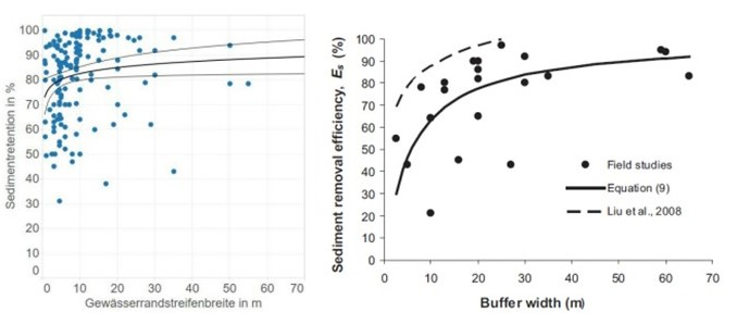
ข้อมูลจำเพาะด้านเทคนิค (แบบแปลนทางเทคนิคของเทคโนโลยี):
Summary of field studies of sediment retention as a function of buffer strip width under controlled, optimal conditions (left figure) and under realistic, non-optimal conditions (right figure).
ผู้เขียน:
Kail et al. (2022), p.37
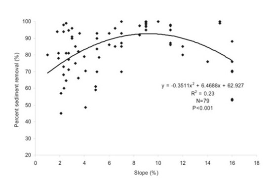
ข้อมูลจำเพาะด้านเทคนิค (แบบแปลนทางเทคนิคของเทคโนโลยี):
Sediment retention as a function of the slope of a buffer strip.
ผู้เขียน:
Kail et al. (2022), p.38
4.2 ข้อมูลทั่วไปเกี่ยวกับการคำนวณปัจจัยนำเข้าและค่าใช้จ่าย
ให้ระบุว่าค่าใช้จ่ายและปัจจัยนำเข้าได้รับการคำนวณอย่างไร:
- ต่อพื้นที่ที่ใช้เทคโนโลยี
ระบุขนาดและหน่วยพื้นที่:
1 ha
อื่นๆ หรือสกุลเงินประจำชาติ (ระบุ):
€
If relevant, indicate exchange rate from USD to local currency (e.g. 1 USD = 79.9 Brazilian Real): 1 USD =:
0.91
ระบุค่าเฉลี่ยของค่าจ้างในการจ้างแรงงานต่อวัน:
18.70€ per hour
4.3 กิจกรรมเพื่อการจัดตั้ง
แสดงความคิดเห็น:
There are no establishment activities needed.
4.5 การบำรุงรักษาสภาพหรือกิจกรรมที่เกิดขึ้นเป็นประจำ
| กิจกรรม | ช่วงระยะเวลา/ความถี่ | |
|---|---|---|
| 1. | Mowing | annually at the end of July |
แสดงความคิดเห็น:
The farmer in this case study mowed the grass and removed the biomass to prevent nutrient saturation in the riparian buffer. However, the amount of hay yield is small and not relevant according to the farmer.
4.6 ค่าใช้จ่ายของปัจจัยนำเข้าและกิจกรรมที่เกิดขึ้นเป็นประจำที่ต้องการการบำรุงรักษา (ต่อปี)
| ปัจจัยนำเข้า | หน่วย | ปริมาณ | ค่าใช้จ่ายต่อหน่วย | ค่าใช้จ่ายทั้งหมดต่อปัจจัยนำเข้า | %ของค่าใช้จ่ายที่ก่อให้เกิดขึ้นโดยผู้ใช้ที่ดิน | |
|---|---|---|---|---|---|---|
| แรงงาน | mowing | ha | 1.0 | 25.0 | 25.0 | |
| ค่าใช้จ่ายทั้งหมดของการบำรุงรักษาสภาพเทคโนโลยี | 25.0 | |||||
| Total costs for maintenance of the Technology in USD | 27.47 | |||||
ถ้าผู้ใช้ที่ดินรับภาระน้อยกว่า 100% ของค่าใช้จ่าย ให้ระบุว่าใครเป็นผู้รับผิดชอบส่วนที่เหลือ:
121€/ha were covered by the state of Saxony as a subsidy (AL 5b- self-vegetated perennial needs on arable land; SMUL Sachsen, 2015).
4.7 ปัจจัยสำคัญที่สุดที่มีผลกระทบต่อค่าใช้จ่าย
ปัจจัยสำคัญที่สุดที่มีผลกระทบต่อค่าใช้จ่ายต่างๆ:
A riparian buffer that developed from set-aside land with naturally recovered vegetation is not costly, as it requires only one mowing operation per year and nothing else. However, the buffer consumes agricultural land, leading to a reduction in agricultural production.
5. สิ่งแวดล้อมทางธรรมชาติและของมนุษย์
5.1 ภูมิอากาศ
ฝนประจำปี
- < 250 ม.ม.
- 251-500 ม.ม.
- 501-750 ม.ม.
- 751-1,000 ม.ม.
- 1,001-1,500 ม.ม.
- 1,501-2,000 ม.ม.
- 2,001-3,000 ม.ม.
- 3,001-4,000 ม.ม.
- > 4,000 ม.ม.
ระบุปริมาณน้ำฝนเฉลี่ยรายปี (ถ้ารู้) :หน่วย ม.ม.
775.00
ระบุชื่อของสถานีตรวดวัดอากาศที่ใช้อ้างอิงคือ:
https://whh-kliwes.de/mapview
เขตภูมิอากาศเกษตร
- กึ่งชุ่มชื้น
Length of growing period (LGP): 209
(https://www.umwelt.sachsen.de/dauer-der-vegetationsperiode-30631.html)
5.2 สภาพภูมิประเทศ
ค่าเฉลี่ยความลาดชัน:
- ราบเรียบ (0-2%)
- ลาดที่ไม่ชัน (3-5%)
- ปานกลาง (6-10%)
- เป็นลูกคลื่น (11-15%)
- เป็นเนิน (16-30%)
- ชัน (31-60%)
- ชันมาก (>60%)
ธรณีสัณฐาน:
- ที่ราบสูง/ที่ราบ
- สันเขา
- ไหล่เขา
- ไหล่เนินเขา
- ตีนเนิน
- หุบเขา
ระดับความสูง:
- 0-100 เมตร
- 101-500 เมตร
- 501-1,000 เมตร
- 1,001-1,500 เมตร
- 1,501-2,000 เมตร
- 2,001-2,500 เมตร
- 2,501-3,000 เมตร
- 3,001-4,000 เมตร
- > 4,000 เมตร
ให้ระบุถ้าเทคโนโลยีได้ถูกนำไปใช้:
- ไม่เกี่ยวข้อง
5.3 ดิน
ค่าเฉลี่ยความลึกของดิน:
- ตื้นมาก (0-20 ซ.ม.)
- ตื้น (21-50 ซ.ม.)
- ลึกปานกลาง (51-80 ซ.ม.)
- ลึก (81-120 ซ.ม.)
- ลึกมาก (>120 ซ.ม.)
เนื้อดิน (ดินชั้นบน):
- หยาบ/เบา (ดินทราย)
เนื้อดินล่าง (> 20 ซ.ม.ต่ำจากผิวดิน):
- หยาบ/เบา (ดินทราย)
อินทรียวัตถุในดิน:
- ปานกลาง (1-3%)
(ถ้ามี) ให้แนบคำอธิบายเรื่องดินแบบเต็มหรือระบุข้อมูลที่มีอยู่ เช่น ชนิดของดิน ค่า pH ของดินหรือความเป็นกรดของดิน ความสามารถในการแลกเปลี่ยนประจุบวก ไนโตรเจน ความเค็ม เป็นต้น:
Gleysol
5.4 ความเป็นประโยชน์และคุณภาพของน้ำ
ระดับน้ำใต้ดิน:
<5 เมตร
น้ำไหลบ่าที่ผิวดิน:
ไม่ดีหรือไม่มีเลย
คุณภาพน้ำ (ที่ยังไม่ได้บำบัด):
เป็นน้ำเพื่อการดื่มที่ไม่ดี (จำเป็นต้องได้รับการบำบัด)
Water quality refers to:
surface water
ความเค็มของน้ำเป็นปัญหาหรือไม่:
ไม่ใช่
กำลังเกิดน้ำท่วมในพื้นที่หรือไม่:
ไม่ใช่
5.5 ความหลากหลายทางชีวภาพ
ความหลากหลายทางชนิดพันธุ์:
- ต่ำ
ความหลากหลายของแหล่งที่อยู่:
- ต่ำ
ความคิดเห็นและข้อมูลจำเพาะเพิ่มเติมของความหลากหลายทางชีวภาพ:
Normally, a self-vegetated fallow has a high species diversity (depending on the seeds present in the soil) and a medium habitat diversity. Unfortunately, the documented self-vegetated fallow is not properly maintained and the beneficial effects, e.g. species and habitat diversity, are correspondingly low.
5.6 ลักษณะของผู้ใช้ที่ดินที่นำเทคโนโลยีไปปฏิบัติใช้
อยู่กับที่หรือเร่ร่อน:
- อยู่กับที่
แนวทางการตลาดของระบบการผลิต:
- ทำการค้า/การตลาด
รายได้ที่มาจากนอกฟาร์ม:
- < 10% ของรายได้ทั้งหมด
ระดับของความมั่งคั่งโดยเปรียบเทียบ:
- พอมีพอกิน
เป็นรายบุคคล/ครัวเรือน:
- เป็นรายบุคคล/ครัวเรือน
ระดับของการใช้เครื่องจักรกล:
- การใช้เครื่องจักรหรือเครื่องยนต์
เพศ:
- หญิง
- ชาย
อายุของผู้ใช้ที่ดิน:
- วัยกลางคน
5.7 Average area of land used by land users applying the Technology
- < 0.5 เฮกตาร์
- 0.5-1 เฮกตาร์
- 1-2 เฮกตาร์
- 2-5 เฮกตาร์
- 5-15 เฮกตาร์
- 15-50 เฮกตาร์
- 50-100 เฮกตาร์
- 100-500 เฮกตาร์
- 500-1,000 เฮกตาร์
- 1,000-10,000 เฮกตาร์
- >10,000 เฮกตาร์
พิจารณาว่าเป็นขนาดเล็ก กลาง หรือขนาดใหญ่ (ซึ่งอ้างอิงถึงบริบทระดับท้องถิ่น):
- ขนาดใหญ่
5.8 กรรมสิทธิ์ในที่ดิน สิทธิในการใช้ที่ดินและสิทธิในการใช้น้ำ
กรรมสิทธิ์ในที่ดิน:
- รายบุคคล ไม่ได้รับสิทธิครอบครอง
สิทธิในการใช้ที่ดิน:
- เช่า
- รายบุคคล
สิทธิในการใช้น้ำ:
- เกี่ยวกับชุมชน (ถูกจัดระเบียบ)
Are land use rights based on a traditional legal system?
ไม่ใช่
5.9 การเข้าถึงบริการและโครงสร้างพื้นฐาน
สุขภาพ:
- จน
- ปานกลาง
- ดี
การศึกษา:
- จน
- ปานกลาง
- ดี
ความช่วยเหลือทางด้านเทคนิค:
- จน
- ปานกลาง
- ดี
การจ้างงาน (เช่น ภายนอกฟาร์ม):
- จน
- ปานกลาง
- ดี
ตลาด:
- จน
- ปานกลาง
- ดี
พลังงาน:
- จน
- ปานกลาง
- ดี
ถนนและการขนส่ง:
- จน
- ปานกลาง
- ดี
น้ำดื่มและการสุขาภิบาล:
- จน
- ปานกลาง
- ดี
บริการด้านการเงิน:
- จน
- ปานกลาง
- ดี
6. ผลกระทบและสรุปคำบอกกล่าว
6.1 ผลกระทบในพื้นที่ดำเนินการ (On-site) จากการใช้เทคโนโลยี
ผลกระทบทางด้านเศรษฐกิจและสังคม
การผลิต
การผลิตพืชผล
คุณภาพพืชผล
การเสี่ยงต่อความล้มเหลวในการผลิต
พื้นที่สำหรับการผลิต
รายได้และค่าใช้จ่าย
ค่าใช่จ่ายของปัจจัยการผลิตทางการเกษตร
รายได้จากฟาร์ม
ความหลากหลายของแหล่งผลิตรายได้
ภาระงาน
ผลกระทบด้านนิเวศวิทยา
วัฐจักรน้ำหรือน้ำบ่า
น้ำไหลบ่าที่ผิวดิน
ดิน
ความชื้นในดิน
สิ่งปกคลุมดิน
การสูญเสียดิน
แสดงความคิดเห็น/ระบุ:
decreased wind erosion
การอัดแน่นของดิน
อินทรียวัตถุในดิน/ต่ำกว่าดินชั้น C
ความหลากหลายทางชีวภาพของพืชและสัตว์
การปกคลุมด้วยพืช
ความหลากหลายทางชีวภาพของพืช
พืชพันธุ์ต่างถิ่นที่รุกล้ำเข้ามา
ความหลากหลายของสัตว์
ลดความเสี่ยงของภัยพิบัติ
ผลกระทบจากภัยแล้ง
Specify assessment of on-site impacts (measurements):
The assessment is based on the response of the interviewed farmer and not based on on-site measurements.
6.2 ผลกระทบนอกพื้นที่ดำเนินการ (Off-site) จากการใช้เทคโนโลยี
การเกิดมลพิษในน้ำบาดาลหรือแม่น้ำ
Specify assessment of off-site impacts (measurements):
The assessment is based on the expertise of the compilers and not based on measurements in the case study.
6.3 การเผชิญและความตอบสนองของเทคโนโลยีต่อการเปลี่ยนแปลงสภาพภูมิอากาศที่ค่อยเป็นค่อยไป และสภาพรุนแรงของภูมิอากาศ / ภัยพิบัติ (ที่รับรู้ได้โดยผู้ใช้ที่ดิน)
การเปลี่ยนแปลงสภาพภูมิอากาศที่ค่อยเป็นค่อยไป
การเปลี่ยนแปลงสภาพภูมิอากาศที่ค่อยเป็นค่อยไป
| ฤดู | increase or decrease | เทคโนโลยีมีวิธีการรับมืออย่างไร | |
|---|---|---|---|
| การเปลี่ยนแปลงสภาพภูมิอากาศที่ค่อยเป็นค่อยไปอื่น ๆ | changing weather conditions | เพิ่มขึ้น | ดี |
6.4 การวิเคราะห์ค่าใช้จ่ายและผลประโยชน์ที่ได้รับ
ผลประโยชน์ที่ได้รับเปรียบเทียบกับค่าใช้จ่ายในการบำรุงรักษาหรือต้นทุนที่เกิดขึ้นซ้ำอีก เป็นอย่างไร (จากมุมมองของผู้ใช้ที่ดิน)
ผลตอบแทนระยะสั้น:
ด้านลบเล็กน้อย
ผลตอบแทนระยะยาว:
ด้านลบเล็กน้อย
แสดงความคิดเห็น:
No establishment costs. Comment by the farmer: "There is no benefit at all".
6.5 การปรับตัวของเทคโนโลยี
- 1-10%
Of all those who have adopted the Technology, how many did so spontaneously, i.e. without receiving any material incentives/ payments?
- 0-10%
6.6 การปรับตัว
เทคโนโลยีได้รับการปรับเปลี่ยนเมื่อเร็วๆนี้ เพื่อให้ปรับตัวเข้ากับสภาพที่กำลังเปลี่ยนแปลงหรือไม่:
ไม่ใช่
6.7 จุดแข็ง / ข้อได้เปรียบ / โอกาสของเทคโนโลยี
| จุดแข็ง / ข้อได้เปรียบ / โอกาสในทัศนคติของผู้รวบรวมหรือวิทยากรหลัก |
|---|
| Increased infiltration rates |
| Reduced erosion and nutrient runoff into watercourse |
| Deeper roots, such as those of trees, stabilize river banks against break-off during heavy rainfall. |
| Trees increase shading and microclimate for stream species. |
6.8 จุดอ่อน / ข้อเสียเปรียบ / ความเสี่ยงของเทคโนโลยีและวิธีการแก้ไข
| จุดอ่อน / ข้อเสียเปรียบ / ความเสี่ยงในทัศนคติของผู้ใช้ที่ดิน | มีวิธีการแก้ไขได้อย่างไร |
|---|---|
| Loss in yield due to loss of arable land. | Accordingly, the yield loss should be offset by subsidies. Use grass mixture as fodder. |
7. การอ้างอิงและการเชื่อมต่อ
7.1 วิธีการและแหล่งข้อมูล
- ไปเยี่ยมชมภาคสนาม การสำรวจพื้นที่ภาคสนาม
1
- การสัมภาษณ์กับผู้ใช้ที่ดิน
1
- การเก็บรวบรวมมาจากรายงานและเอกสารที่มีอยู่
6
วันที่เก็บรวบรวมข้อมูล(ภาคสนาม) :
16/03/2023
7.2 การอ้างอิงถึงสิ่งตีพิมพ์
หัวข้อ, ผู้เขียน, ปี, หมายเลข ISBN:
Kail et al. (2022): Ökologische Funktionen von Gewässerrandstreifen. LfULG Broschüre
ชื่อเรื่อง ผู้เขียน ปี ISBN:
https://publikationen.sachsen.de/bdb/artikel/40152
7.3 Links to relevant online information
ชื่อเรื่องหรือคำอธิบาย:
Cole et al. (2020): Managing riparian buffer strips to optimise ecosystem services: A review. Agriculture, Ecosystems & Environment 296
URL:
https://doi.org/10.1016/j.agee.2020.106891
ชื่อเรื่องหรือคำอธิบาย:
SMUL Sachsen (2015): Förderperiode 2014-2020 - Art. 28 der Verordnung (EU) Nr. 1305/2013 - Richtlinie Agrarumwelt- und Klimamaßnahmen (RL AUK/2015) - Sächsisches Agrarumwelt- und Naturschutzprogramm (AUNaP)
URL:
https://www.smul.sachsen.de/lfulg/download/AUK-Massnahmen-Ueberblick.pdf
ชื่อเรื่องหรือคำอธิบาย:
Hebblethwaite & Somody (2008): Progress in Best Management Practices. In: The Triazine Herbicides. 50 years Revolutionizing Agriculture
URL:
https://doi.org/10.1016/B978-044451167-6.50035-0
ลิงก์และโมดูล
ขยายทั้งหมด ย่อทั้งหมดลิงก์
ไม่มีลิงก์
โมดูล
ไม่มีโมดูล