
Riparian buffer strip with naturally recovered vegetation [德国]
- 创建:
- 更新:
- 编制者: Felix Witing
- 编辑者: Michael Strauch, Mona Pauer
- 审查者: William Critchley, Rima Mekdaschi Studer
Selbstbegrünte Brache als Gewässerrandstreifen
technologies_6258 - 德国
查看章节
全部展开 全部收起1. 一般信息
1.2 参与该技术评估和文件编制的资源人员和机构的联系方式
SLM专业人员:
SLM专业人员:
有助于对技术进行记录/评估的项目名称(如相关)
OPtimal strategies to retAIN and re-use water and nutrients in small agricultural catchments across different soil-climatic regions in Europe (OPTAIN)有助于对技术进行记录/评估的机构名称(如相关)
Helmholtz Centre for Environmental Research (UFZ) - 德国1.3 关于使用通过WOCAT记录的数据的条件
编制者和关键资源人员接受有关使用通过WOCAT记录数据的条件。:
是
1.4 所述技术的可持续性声明
这里所描述的技术在土地退化方面是否存在问题,导致无法被认为是一种可持续的土地管理技术?:
否
2. SLM技术的说明
2.1 技术简介
技术定义:
Riparian buffer strips refer to the permanent greening of arable land alongside streams and other water bodies. By slowing down runoff water from the land, they help to protect water bodies from diffuse pollution. Riparian buffer strips have multiple other environmental benefits, but disadvantages also.
2.2 技术的详细说明
说明:
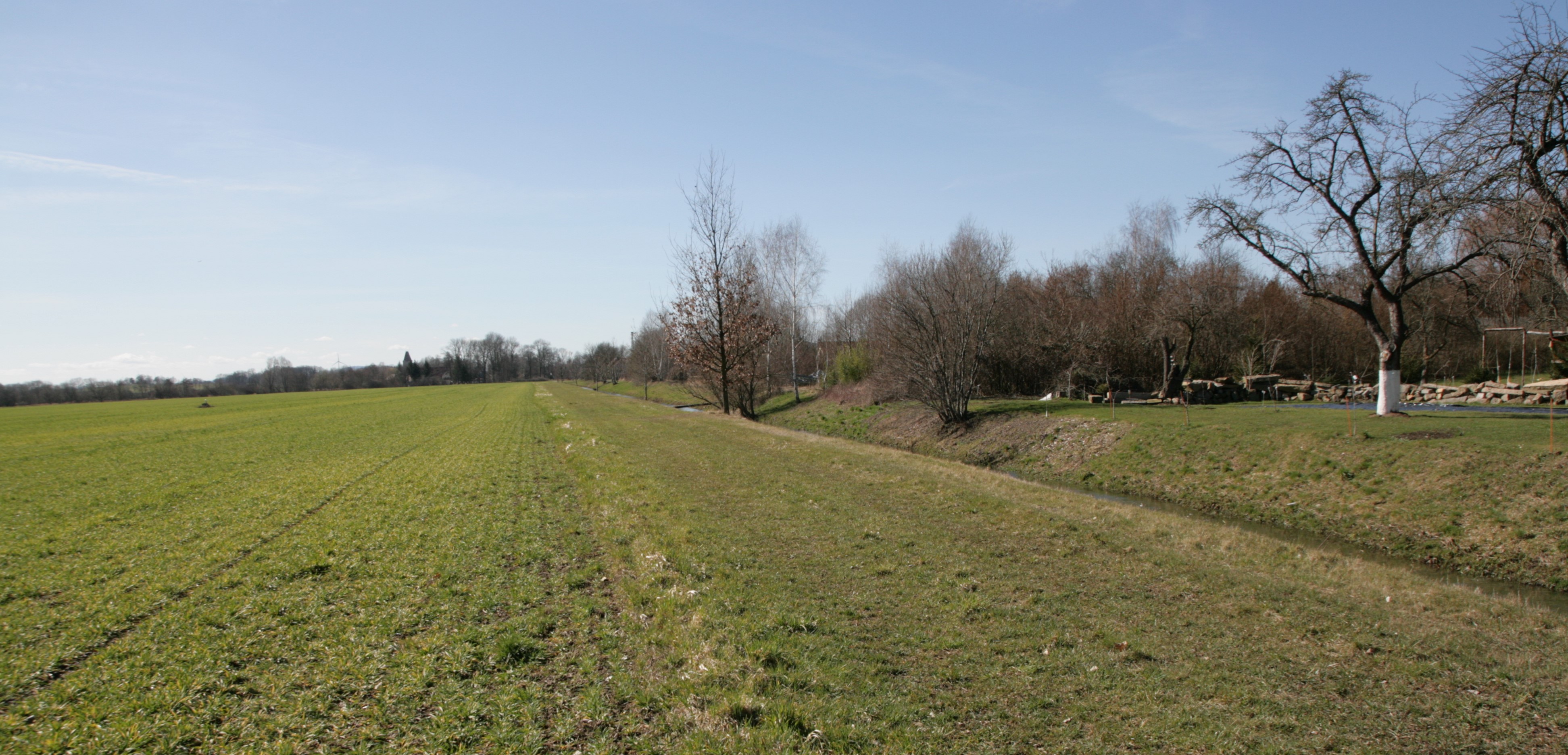
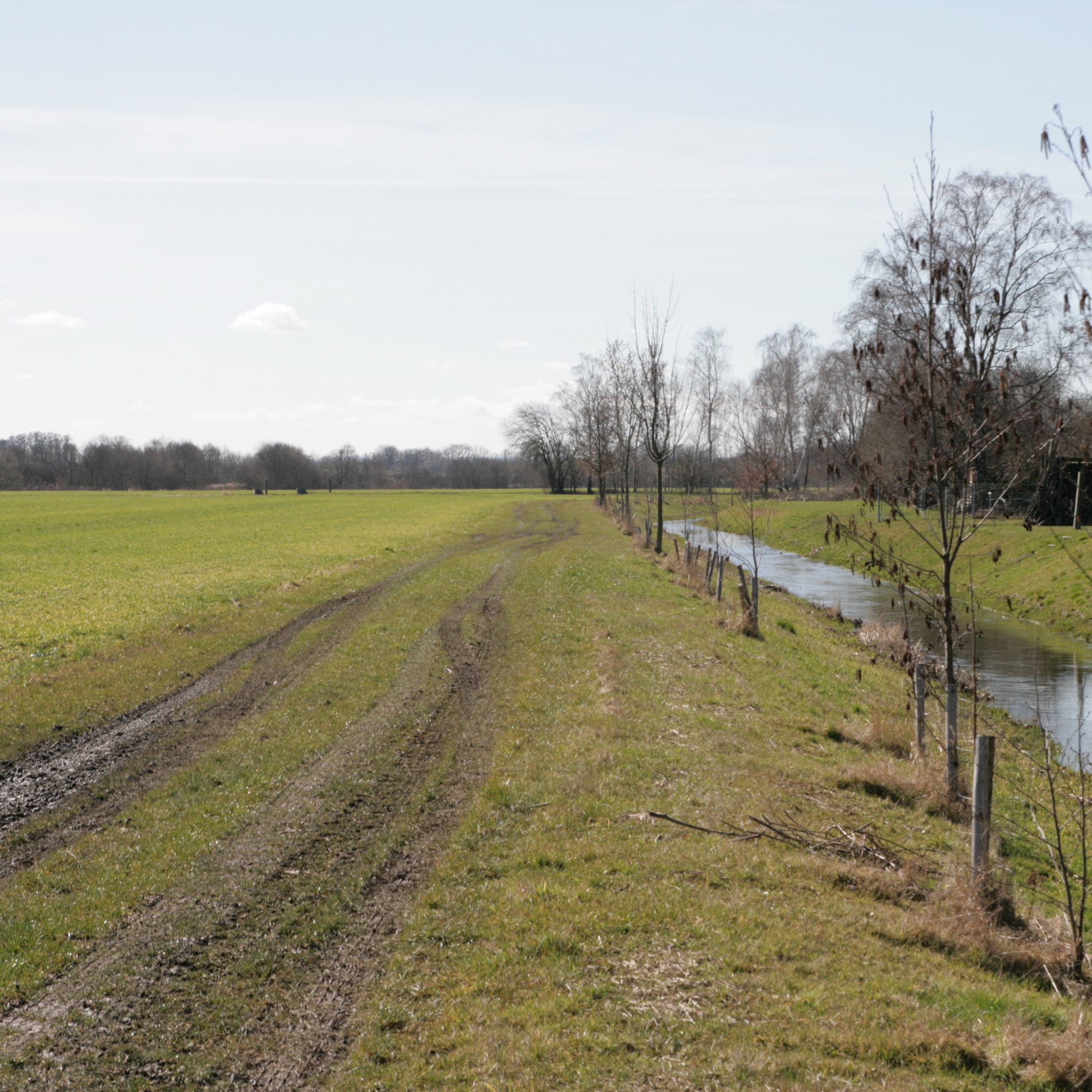
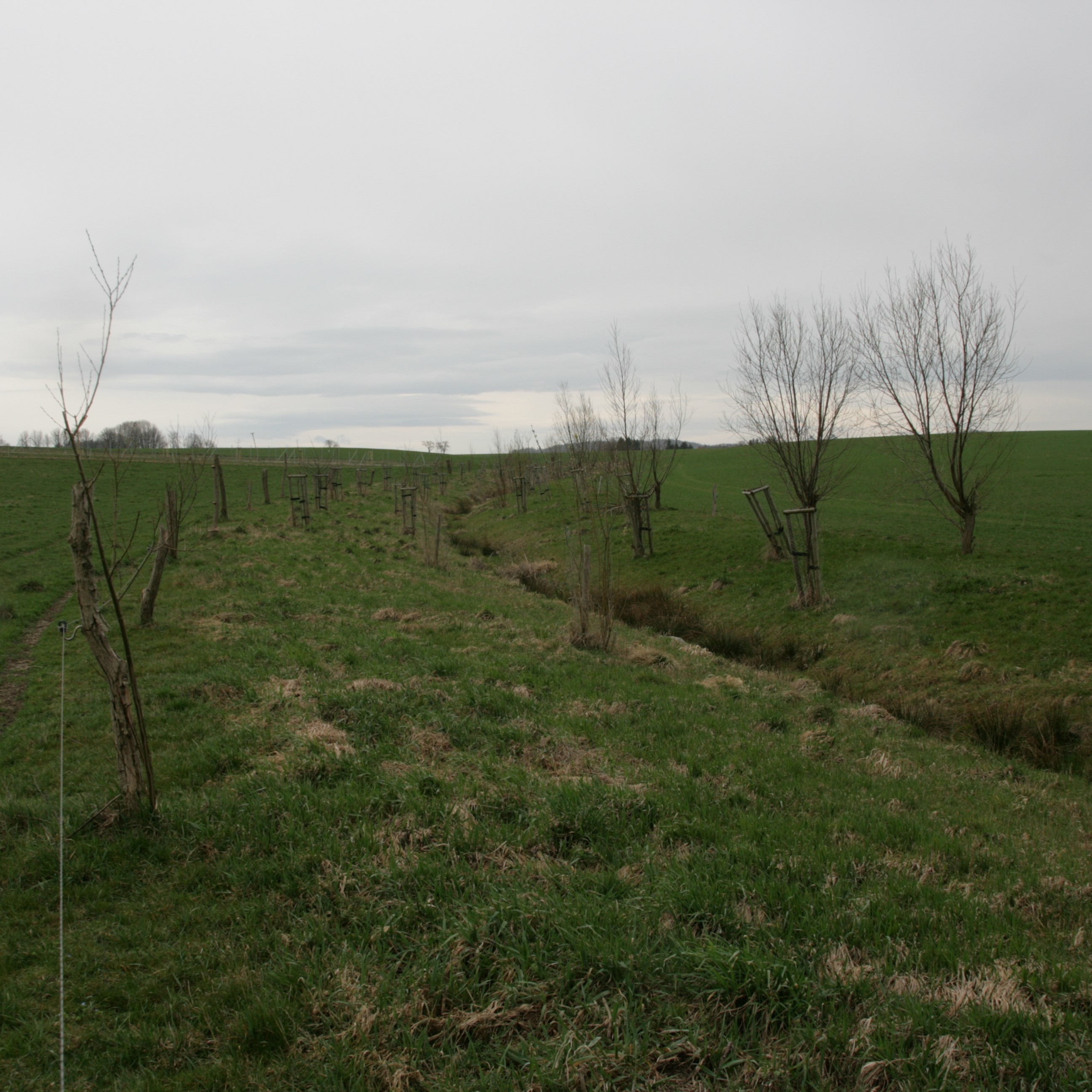
Riparian buffer strips comprise permanent, protective vegetation alongside streams and other water bodies. Our example represents a riparian buffer that evolved from set-aside land with naturally recovered vegetation. For the farmer, this has several advantages in terms of implementation, maintenance and seed costs. The farmer was able to simply leave the buffer strip open after ploughing without seeding or rolling, and maintenance requires only one mowing operation per year.
Riparian buffer strips are established at the edge of cultivated areas adjacent to water bodies. The width of the strip should be 5-15 m. In our example, the width of the buffer strip was 6 m, which was defined by working width of the mower. Depending on the type and width of the buffer, the rainfall intensity, the slope and the management, different filtering capacities can be attained by a buffer. An effective strip can retain 70% of the sediment and reduce nutrients in the surface runoff by 50%. However efficient retention of nutrients requires a buffer width of at least 15 m, while efficient retention of fine sediments requires a width of 15-20 m. The slope of the watercourse bank is also important: the optimum slope is 9-10%, and retention performance worsens with increasing slope (Kail et al. 2022).
Grass cover roughens the soil surface, slowing down the flow of water after heavy rainfall events and improving infiltration rates. Additionally, the roots of grasses increase infiltration, the plants absorb nitrate and prevent it from running off into the water bodies. Deeper roots, such as those from trees stabilize river banks, preventing bank erosion during heavy rainfall, as well as increasing shading of the stream. This improves the microclimate and creates better habitats for species native to the watercourse. Moreover, the buffer reduces the siltation of water bodies, preserves gravel bars, and thus preserves habitats. The buffer strip itself provides habitats for flora and fauna. The area adjacent to the buffer strip may experience increased dew formation and soil moisture, reduced evaporation, and wind protection.
The surface roughness of the grassed buffer strip depends on the type of vegetation. Cold-tolerant grasses such as perennial ryegrass (Lolium perenne) are commonly used, but a mix of grasses and trees is even better. Grassland provides an evenly distributed surface cover and the trees, with their deeper roots, provider higher infiltration capacity. Fast growing, low maintenance and regional species are optimal.
Proper maintenance is important for permanent erosion control. In case of nutrient-rich runoff from adjacent fields, the buffer strip may become saturated after a while and nitrification increases. Nitrous oxide is then produced which is a powerful greenhouse gases. In addition, the soil/vegetation is no longer able to absorb new nutrients, and they are washed into the water body. Mowing once per year removes biomass and can prevent nutrient saturation (Cole et al. 2020).
However, while promoting biodiversity and reducing soil erosion, buffer strips have a major downside for land-users and land-owners. They consume cropland, which leads to a decrease in production. The grass mixture can be used as fodder, but usually this does not compensate for the loss of production, which is why farmers often call for appropriate subsidies.
2.3 技术照片
媒体库
2.5 已应用该技术的、本评估所涵盖的国家/地区/地点
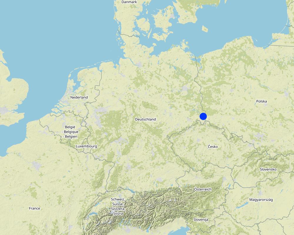
国家:
德国
区域/州/省:
Saxony
有关地点的进一步说明:
Nieder Seifersdorf
具体说明该技术的分布:
- 适用于特定场所/集中在较小区域
技术现场是否位于永久保护区?:
否
Map
×2.6 实施日期
注明实施年份:
2013
2.7 技术介绍
详细说明该技术是如何引入的:
- 通过项目/外部干预
注释(项目类型等):
In order to meet the greening requirements of the CAP, 4% of the total agricultural area of a farm must be used, for example, for crop diversification, maintenance of permanent grassland or creation of ecological priority areas in order to receive direct payments from the state. In this case, a self-vegetated fallow was established as an ecological priority area to fulfill the greening requirements.
3. SLM技术的分类
3.1 该技术的主要目的
- 减少、预防、恢复土地退化
- 保护生态系统
- 结合其他技术保护流域/下游区域
- 保持/提高生物多样性
3.2 应用该技术的当前土地利用类型
同一土地单元内混合使用的土地::
否

不毛之地
具体说明:
self-vegetated fallow
注释:
maintenance activity: mowing
3.3 由于技术的实施,土地使用是否发生了变化?
由于技术的实施,土地使用是否发生了变化?:
- 是(请在技术实施前填写以下有关土地利用的问题)
同一土地单元内混合使用的土地::
否

农田
- 一年一作
年作 - 具体指明作物:
- 谷类 - 大麦
- 谷物类 - 玉米
- 谷类 - 黑麦
- 谷类 - 小麦(冬季)
采用间作制度了吗?:
否
采用轮作制度了吗?:
是
如果是,请具体说明:
winter rye, winter wheat, silage maize, winter wheat, winter rye, winter barley, silage maize, winter barley, winter rye
3.4 供水
该技术所应用土地的供水:
- 雨养
3.5 该技术所属的SLM组
- 区域封闭(停止使用,支持恢复)
- 改良的地面/植被覆盖
- 横坡措施
3.6 包含该技术的可持续土地管理措施

植物措施
- V2:草和多年生草本植物
3.7 该技术强调的主要土地退化类型

土壤水蚀
- Wt:表土流失/地表侵蚀
- Wg:冲沟侵蚀/沟蚀
- Wr:河岸侵蚀
- Wo:场外劣化效应

化学性土壤退化
- Cn:肥力下降和有机质含量下降(非侵蚀所致)

物理性土壤退化
- Pc:压实
- Pk:熟化和结壳
- Pw:水浸

生物性退化
- Bc:植被覆盖的减少
- Bh:栖息地丧失
- Bs:质量和物种组成/多样性的下降
- Bl:土壤寿命损失

水质恶化
- Hp:地表水水质下降
- Hq:地下水水质下降
- Hw:湿地缓冲能力下降
3.8 防止、减少或恢复土地退化
具体数量名该技术与土地退化有关的目标:
- 防止土地退化
- 减少土地退化
4. 技术规范、实施活动、投入和成本
4.1 该技术的技术图纸
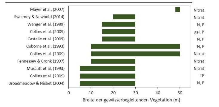
技术规范(与技术图纸相关):
Widths of the vegetation along the watercourse required for effective nutrient retention (approx. >80%) mentioned in the reviews.
作者:
Kail et al. (2022), p.25
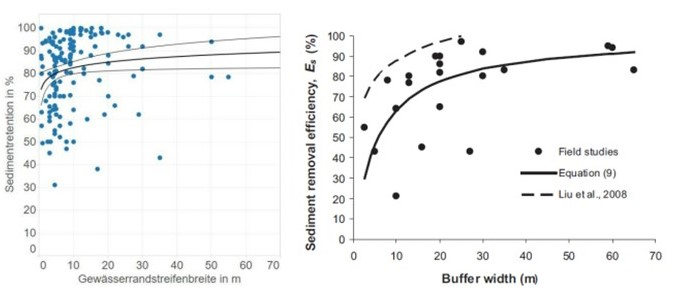
技术规范(与技术图纸相关):
Summary of field studies of sediment retention as a function of buffer strip width under controlled, optimal conditions (left figure) and under realistic, non-optimal conditions (right figure).
作者:
Kail et al. (2022), p.37
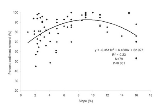
技术规范(与技术图纸相关):
Sediment retention as a function of the slope of a buffer strip.
作者:
Kail et al. (2022), p.38
4.2 有关投入和成本计算的一般信息
具体说明成本和投入是如何计算的:
- 每个技术区域
注明尺寸和面积单位:
1 ha
其它/国家货币(具体说明):
€
如相关,注明美元与当地货币的汇率(例如1美元=79.9巴西雷亚尔):1美元=:
0.91
注明雇用劳工的每日平均工资成本:
18.70€ per hour
4.3 技术建立活动
注释:
There are no establishment activities needed.
4.5 维护/经常性活动
| 活动 | 时间/频率 | |
|---|---|---|
| 1. | Mowing | annually at the end of July |
注释:
The farmer in this case study mowed the grass and removed the biomass to prevent nutrient saturation in the riparian buffer. However, the amount of hay yield is small and not relevant according to the farmer.
4.6 维护/经常性活动所需要的费用和投入(每年)
| 对投入进行具体说明 | 单位 | 数量 | 单位成本 | 每项投入的总成本 | 土地使用者承担的成本% | |
|---|---|---|---|---|---|---|
| 劳动力 | mowing | ha | 1.0 | 25.0 | 25.0 | |
| 技术维护所需总成本 | 25.0 | |||||
| 技术维护总成本,美元 | 27.47 | |||||
如果土地使用者负担的费用少于100%,请注明由谁负担其余费用:
121€/ha were covered by the state of Saxony as a subsidy (AL 5b- self-vegetated perennial needs on arable land; SMUL Sachsen, 2015).
4.7 影响成本的最重要因素
描述影响成本的最决定性因素:
A riparian buffer that developed from set-aside land with naturally recovered vegetation is not costly, as it requires only one mowing operation per year and nothing else. However, the buffer consumes agricultural land, leading to a reduction in agricultural production.
5. 自然和人文环境
5.1 气候
年降雨量
- < 250毫米
- 251-500毫米
- 501-750毫米
- 751-1,000毫米
- 1,001-1,500毫米
- 1,501-2,000毫米
- 2,001-3,000毫米
- 3,001-4,000毫米
- > 4,000毫米
指定年平均降雨量(若已知),单位为mm:
775.00
注明所考虑的参考气象站名称:
https://whh-kliwes.de/mapview
农业气候带
- 半湿润
Length of growing period (LGP): 209
(https://www.umwelt.sachsen.de/dauer-der-vegetationsperiode-30631.html)
5.2 地形
平均坡度:
- 水平(0-2%)
- 缓降(3-5%)
- 平缓(6-10%)
- 滚坡(11-15%)
- 崎岖(16-30%)
- 陡峭(31-60%)
- 非常陡峭(>60%)
地形:
- 高原/平原
- 山脊
- 山坡
- 山地斜坡
- 麓坡
- 谷底
垂直分布带:
- 0-100 m a.s.l.
- 101-500 m a.s.l.
- 501-1,000 m a.s.l.
- 1,001-1,500 m a.s.l.
- 1,501-2,000 m a.s.l.
- 2,001-2,500 m a.s.l.
- 2,501-3,000 m a.s.l.
- 3,001-4,000 m a.s.l.
- > 4,000 m a.s.l.
说明该技术是否专门应用于:
- 不相关
5.3 土壤
平均土层深度:
- 非常浅(0-20厘米)
- 浅(21-50厘米)
- 中等深度(51-80厘米)
- 深(81-120厘米)
- 非常深(> 120厘米)
土壤质地(表土):
- 粗粒/轻(砂质)
土壤质地(地表以下> 20厘米):
- 粗粒/轻(砂质)
表土有机质:
- 中(1-3%)
如有可能,附上完整的土壤描述或具体说明可用的信息,例如土壤类型、土壤酸碱度、阳离子交换能力、氮、盐度等。:
Gleysol
5.4 水资源可用性和质量
地下水位表:
< 5米
地表水的可用性:
匮乏/没有
水质(未处理):
不良饮用水(需要处理)
水质请参考::
地表水
水的盐度有问题吗?:
否
该区域正在发生洪水吗?:
否
5.5 生物多样性
物种多样性:
- 低
栖息地多样性:
- 低
关于生物多样性的注释和进一步规范:
Normally, a self-vegetated fallow has a high species diversity (depending on the seeds present in the soil) and a medium habitat diversity. Unfortunately, the documented self-vegetated fallow is not properly maintained and the beneficial effects, e.g. species and habitat diversity, are correspondingly low.
5.6 应用该技术的土地使用者的特征
定栖或游牧:
- 定栖的
生产系统的市场定位:
- 商业/市场
非农收入:
- 低于全部收入的10%
相对财富水平:
- 平均水平
个人或集体:
- 个人/家庭
机械化水平:
- 机械化/电动
性别:
- 女人
- 男人
土地使用者的年龄:
- 中年人
5.7 应用该技术的土地使用者使用的平均土地面积
- < 0.5 公顷
- 0.5-1 公顷
- 1-2 公顷
- 2-5公顷
- 5-15公顷
- 15-50公顷
- 50-100公顷
- 100-500公顷
- 500-1,000公顷
- 1,000-10,000公顷
- > 10,000公顷
这被认为是小规模、中规模还是大规模的(参照当地实际情况)?:
- 大规模的
5.8 土地所有权、土地使用权和水使用权
土地所有权:
- 个人,未命名
土地使用权:
- 租赁
- 个人
用水权:
- 社区(有组织)
土地使用权是否基于传统的法律制度?:
否
5.9 进入服务和基础设施的通道
健康:
- 贫瘠
- 适度的
- 好
教育:
- 贫瘠
- 适度的
- 好
技术援助:
- 贫瘠
- 适度的
- 好
就业(例如非农):
- 贫瘠
- 适度的
- 好
市场:
- 贫瘠
- 适度的
- 好
能源:
- 贫瘠
- 适度的
- 好
道路和交通:
- 贫瘠
- 适度的
- 好
饮用水和卫生设施:
- 贫瘠
- 适度的
- 好
金融服务:
- 贫瘠
- 适度的
- 好
6. 影响和结论性说明
6.1 该技术的现场影响
社会经济效应
生产
作物生产
作物质量
生产故障风险
生产区域
收入和成本
农业投入费用
农业收入
收入来源的多样性
工作量
生态影响
水循环/径流
地表径流
土壤
土壤水分
土壤覆盖层
土壤流失
注释/具体说明:
decreased wind erosion
土壤压实
土壤有机物/地下C
生物多样性:植被、动物
植被覆盖
植物多样性
外来入侵物种
栖息地多样性
减少气候和灾害风险
干旱影响
对现场影响的评估(测量)进行具体说明:
The assessment is based on the response of the interviewed farmer and not based on on-site measurements.
6.2 该技术的场外影响已经显现
地下水/河流污染
对场外影响(测量)的评估进行具体说明:
The assessment is based on the expertise of the compilers and not based on measurements in the case study.
6.3 技术对渐变气候以及与气候相关的极端情况/灾害的暴露和敏感性(土地使用者认为的极端情况/灾害)
渐变气候
渐变气候
| 季节 | 增加或减少 | 该技术是如何应对的? | |
|---|---|---|---|
| 其他渐变气候 | changing weather conditions | 增加 | 好 |
6.4 成本效益分析
技术收益与技术维护成本/经常性成本相比如何(从土地使用者的角度看)?
短期回报:
轻度消极
长期回报:
轻度消极
注释:
No establishment costs. Comment by the farmer: "There is no benefit at all".
6.5 技术采用
- 1-10%
在所有采用这项技术的人当中,有多少人是自发的,即未获得任何物质奖励/付款?:
- 0-10%
6.6 适应
最近是否对该技术进行了修改以适应不断变化的条件?:
否
6.7 该技术的优点/长处/机会
| 编制者或其他关键资源人员认为的长处/优势/机会 |
|---|
| Increased infiltration rates |
| Reduced erosion and nutrient runoff into watercourse |
| Deeper roots, such as those of trees, stabilize river banks against break-off during heavy rainfall. |
| Trees increase shading and microclimate for stream species. |
6.8 技术的弱点/缺点/风险及其克服方法
| 土地使用者认为的弱点/缺点/风险 | 如何克服它们? |
|---|---|
| Loss in yield due to loss of arable land. | Accordingly, the yield loss should be offset by subsidies. Use grass mixture as fodder. |
7. 参考和链接
7.1 信息的方法/来源
- 实地考察、实地调查
1
- 与土地使用者的访谈
1
- 根据报告和其他现有文档进行编译
6
(现场)数据是什么时候汇编的?:
16/03/2023
7.2 参考可用出版物
标题、作者、年份、ISBN:
Kail et al. (2022): Ökologische Funktionen von Gewässerrandstreifen. LfULG Broschüre
可以从哪里获得?成本如何?
https://publikationen.sachsen.de/bdb/artikel/40152
7.3 链接到网络上的相关信息
标题/说明:
Cole et al. (2020): Managing riparian buffer strips to optimise ecosystem services: A review. Agriculture, Ecosystems & Environment 296
URL:
https://doi.org/10.1016/j.agee.2020.106891
标题/说明:
SMUL Sachsen (2015): Förderperiode 2014-2020 - Art. 28 der Verordnung (EU) Nr. 1305/2013 - Richtlinie Agrarumwelt- und Klimamaßnahmen (RL AUK/2015) - Sächsisches Agrarumwelt- und Naturschutzprogramm (AUNaP)
URL:
https://www.smul.sachsen.de/lfulg/download/AUK-Massnahmen-Ueberblick.pdf
标题/说明:
Hebblethwaite & Somody (2008): Progress in Best Management Practices. In: The Triazine Herbicides. 50 years Revolutionizing Agriculture
URL:
https://doi.org/10.1016/B978-044451167-6.50035-0
链接和模块
全部展开 全部收起链接
无链接
模块
无模块