Participatory mapping, database building, and monitoring of rangeland resources [Kenya]
- Creation:
- Update:
- Compiler: IBRAHIM JARSO
- Editor: Caroline King-Okumu
- Reviewers: Hanspeter Liniger, Rima Mekdaschi Studer, Donia Mühlematter, Joana Eichenberger
Resource Mapping
approaches_3439 - Kenya
- Full summary as PDF
- Full summary as PDF for print
- Full summary in the browser
- Full summary (unformatted)
- Participatory mapping, database building, and monitoring of rangeland resources: July 5, 2018 (inactive)
- Participatory mapping, database building, and monitoring of rangeland resources: July 31, 2018 (inactive)
- Participatory mapping, database building, and monitoring of rangeland resources: July 5, 2018 (inactive)
- Participatory mapping, database building, and monitoring of rangeland resources: Sept. 3, 2018 (inactive)
- Participatory mapping, database building, and monitoring of rangeland resources: May 22, 2018 (inactive)
- Participatory mapping, database building, and monitoring of rangeland resources: May 13, 2018 (inactive)
- Participatory mapping, database building, and monitoring of rangeland resources: Nov. 2, 2021 (public)
- Participatory mapping, database building, and monitoring of rangeland resources: May 19, 2018 (inactive)
View sections
Expand all Collapse all1. General information
1.2 Contact details of resource persons and institutions involved in the assessment and documentation of the Approach
Key resource person(s)
SLM specialist:
land user:
Konsole Hussein
+254 728 064578
saritehussein@yahoo.com
Garbatulla Ward Adaptation Planning Committee
P.O. BOX 1Garbatulla
Kenya
Non-State Actor:
Abdullahi Shandey
+254 721109171
midp2003@gmail.com
Merti Integrated Development Program (MID-P)
Merti VillageIsiolo Kenya
Kenya
SLM specialist:
Name of project which facilitated the documentation/ evaluation of the Approach (if relevant)
Strengthening Adaptation and Resilience to Climate Change in Kenya Plus (StARCK+)Name of project which facilitated the documentation/ evaluation of the Approach (if relevant)
Book project: Guidelines to Rangeland Management in Sub-Saharan Africa (Rangeland Management) {'additional_translations': {}, 'value': 6142, 'label': 'Name of the institution(s) which facilitated the documentation/ evaluation of the Approach (if relevant)', 'text': 'Resource Advocacy Programme (RAP) - Kenya', 'template': 'raw'}1.3 Conditions regarding the use of data documented through WOCAT
When were the data compiled (in the field)?
16/01/2018
The compiler and key resource person(s) accept the conditions regarding the use of data documented through WOCAT:
Yes
2. Description of the SLM Approach
2.1 Short description of the Approach
Participatory mapping and monitoring of vegetation types and other natural resources in the rangelands. This involves convening stakeholder groups, reviewing conditions of rangeland, water and other resources under changing climatic conditions.
2.2 Detailed description of the Approach
Detailed description of the Approach:
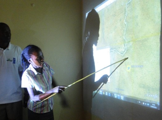
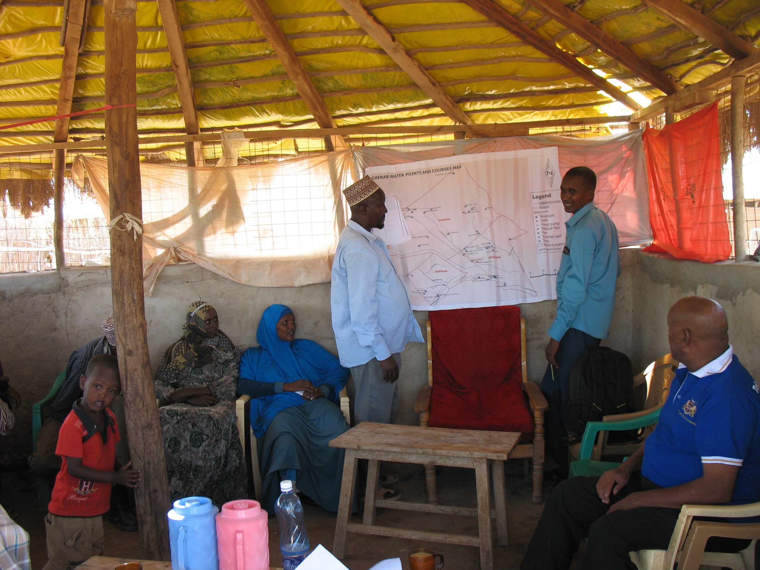
Participatory digital mapping using satellite imagery and digital earth and other open source Geographic Information Systems (GIS) is a practical tool that can bridge knowledge and communication gaps between pastoral communities and county government planners. It offers an effective ‘tool’ for participatory planning and decision-making in support of climate change adaptation efforts in the drylands of Kenya.The use of participatory mapping is not new in seeking to capture communities’ understanding and use of natural resources. These maps are typically drawn on the ground using stones, sticks and other locally available materials to depict key features such as schools, water points, and forest areas, etc. However the process used in Isiolo County combines digital mapping with community-drawn perception maps. This offers a number of extra benefits. While fully capturing the wealth of local knowledge, they contain an in-built coordinate system which corresponds to a global reference grid, enabling their linkage to maps used in formal systems. Furthermore, the coordinate system provides a geographically precise basis from which to discuss natural resource management, making outputs of participatory mapping more universally useable. These benefits, however, need to be carefully balanced to avoid the risk that through this process, pastoral resources – which are highly dynamic - are ‘frozen’ in time and space. Mapping processThe participatory mapping process has adopted GIS workflows within community workshops, enabling the creation of integrated, consistent and standardized geospatial information. The process follows seven steps:Step 1: Community level meetings to develop perception maps drawn on the ground and/or on paper. The product is a community perception map of those resources that are important for their livelihood systems. This map should be created in a community setting to enable the participation of a large group. Several maps may be produced by smaller sub-groups (women, the youth, elders etc) and then amalgamated. The final map is then copied onto paper. Step 2. Digital mapping is introduced. This step takes place in a workshop setting with a smaller group of key informants chosen by the community - as well as county government planners and technical staff. The presence of the latter is critical to the process of ‘legitimizing’ community knowledge. Following a quick explanation of satellite imagery, Google Earth is projected onto a wall alongside the perception maps developed under step 1. The use of Google Earth is only for orientation, and to enable participants to navigate the imagery and to cross-reference their paper-mapped key resources against the satellite imagery. Features that participants feel are important (e.g. water points, wet and dry season grazing areas, drought reserves, wildlife routes) are then captured digitally using open source applications: Quantum GIS (QGIS) and JOSM, the Open Street Map editing platform.This produces the coordinates that pinpoint the locations of natural resources in a manner that can be independently and objectively verified. The highly interactive process of geo-referencing local knowledge to a coordinate reference system allows resource maps to be produced to any scale, and in real-time, with the community. Step 3. Qualitative and quantitative attributes describing the key resources are collected. As participants add features to the map, they also describe their specified characteristics or attributes. Attribution data includes a fuller description of the physical characteristics of the resource (e.g. soil type, waterquantity and quality, pasture species) as well as issues concerning their management (e.g. under customary or modern management, land tenure status, negotiated or paid access, area of conflict). Updating this data on a regular basis adds temporal and trend data to the spatial database. This underlines the need to structure data systems well to manage time-based data and to record updates.Steps 4-6: Data verification cycles are integrated into the mapping process in order to capture community feedback and verify the records in the geospatial data and their attribute values against the specification. The mapping includes a series of validation, cross-checking and verification cycles, run with the community - and in a few instances on-the-ground verification termed ‘groundtruthing’. Step 7: Field validation. Field validation is carried out where the verification stages highlight gaps in information. Verification consists of targeted field visits to take GPS markers, or holding meetings with the local community to clarify particular issues.
2.3 Photos of the Approach
Media Gallery

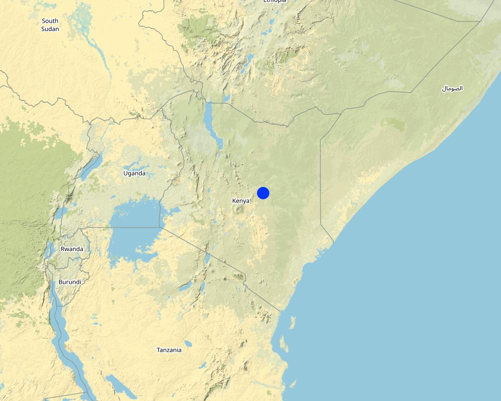
2.5 Country/ region/ locations where the Approach has been applied
Country:
Kenya
Region/ State/ Province:
Isiolo
Further specification of location:
Pasturalist areas
Map
×2.6 Dates of initiation and termination of the Approach
Indicate year of initiation:
2012
Year of termination (if Approach is no longer applied):
2015
Comments:
The mapping process needs to be continuous as new community resources are identified and added
2.7 Type of Approach
- project/ programme based
2.8 Main aims/ objectives of the Approach
- To allow participation for community groups to inform planners.- To provide the necessary precision for planners to use local knowledge effectively.- To make a ‘bridge’ for information to flow between customary and formal institutions.- To better share ideas through communication tools using powerful visual language.- To demonstrate the depth of local knowledge about natural resources and with that, demonstrate the importance of these resources.- To identify gaps and risks in the system being mapped.- To compare one plan with another to see how complimentary/contradictory they are.
2.9 Conditions enabling or hindering implementation of the Technology/ Technologies applied under the Approach
social/ cultural/ religious norms and values
- enabling
Communities are awed by the technology that allows them to see their resources while seated in a single specific location. The approach doesn't conflict with any community social, cultural, religious norms and values.
- hindering
Minimal local capacity is required to use the technology.
availability/ access to financial resources and services
- enabling
A brief GIS training of four weeks can allow county government staff to develop, add and update the database.
- hindering
Short GIS training courses costs around $850 and facilitation of community engagement meetings may be costly to undertake.
institutional setting
- enabling
The approach helps in improving planning at community and government levels, and is accepted by all stakeholders.
- hindering
Poor capacity and financial resources can be a challenge.
collaboration/ coordination of actors
- enabling
The product of the participatory mapping process is beneficial to all actors and many are willing to engage in implementation of the approach.
- hindering
Different mapping initiatives are undertaken by actors with various objectives.
legal framework (land tenure, land and water use rights)
- enabling
The approach helps in land use planning and supports regulations meant to improve land governance such as a customary natural resource management bill.
- hindering
County governments can develop their own spatial plans, but there are only few initiatives underway to map county resources
policies
- enabling
Many policies and laws (including the national constitution) support the mapping of resources to improve land use planning.
- hindering
Conflicts over land undermines political will.
land governance (decision-making, implementation and enforcement)
- enabling
The approach allows communities to develop their land use plans for resource utilisation, and digitize them - making the work of land governance easier.
- hindering
Competing claims over land and land-based resources in community lands means enforcement of the approach is often challenged. Resources along administrative boundaries are claimed by different communities.
knowledge about SLM, access to technical support
- enabling
New graduates in dryland resource management, and communities' reception of the new technologies, help in acceptance and implementation of the technology.
- hindering
58% of the residents of the county (according to the Kenya National Bureau of Statistics socio-economic survey report of 2016) are illiterate and may have difficulties engaging properly with the technology.
markets (to purchase inputs, sell products) and prices
- enabling
Free open source programmes are available to digitize local knowledge to geo-referenced products.
- hindering
Good programmes for mapping are expensive.
workload, availability of manpower
- enabling
The technology makes the process simpler and reduces the workload.
- hindering
The processes can be tedious because of the paper maps involved, series of validation and verification of features.
3. Participation and roles of stakeholders involved
3.1 Stakeholders involved in the Approach and their roles
- local land users/ local communities
Jarsa Dedha (customary natural resource management institutions) Community Members (i.e. pastoralists).
Jarsa Dedha identify the most knowledgeable elders from different grazing areas to help in identifying features and providing grazing land management plans that are in place. Community members identify features and contribute to the attributes of the features.
- community-based organizations
Kinna Integrated community based initiative (KICBI)Ward Adaptation Planning Committees
They identify features and also contribute to attributes of the features
- SLM specialists/ agricultural advisers
Ibrahim Jarso
Support mapping process and also add new features supporting updates to the products.
- NGO
Resource Advocacy Program (RAP)Merti Integrated Development Program (MID-P)Adaptation Consortium
Support the mapping process and mobilize communities and stakeholders for the approach to be implemented properly.
- local government
Isiolo County Government
Support the mapping process with intention to use product for planning purpose and own the product
- national government (planners, decision-makers)
Kenya's National Government
Support the planning process - also with the intention of using the product for planning.
- international organization
International Institute for Environment and Development (IIED) and theUniversity of Southampton (Geodata Institute)
Support with funding to implement the approach and also provide technical expertise to undertake GIS processing of data.
If several stakeholders were involved, indicate lead agency:
WAPC , ADA and IIED
3.2 Involvement of local land users/ local communities in the different phases of the Approach
| Involvement of local land users/ local communities | Specify who was involved and describe activities | |
|---|---|---|
| initiation/ motivation | passive | Resource Advocacy Programme (RAP) undertook discussions with the local community and also with the county and national government in shaping the idea for the approach. |
| planning | interactive | All stakeholders (community, RAP, ADA, IIED, Geodata and Governments) were engaged in the planning for the implementation of the Approach. |
| implementation | interactive | Community members and all stakeholders were involved in the implementation of the participatory mapping. |
| monitoring/ evaluation | passive | The county government and the actors (RAP, ADA and IIED) monitor the participatory mapping database and improves it. |
3.3 Flow chart (if available)
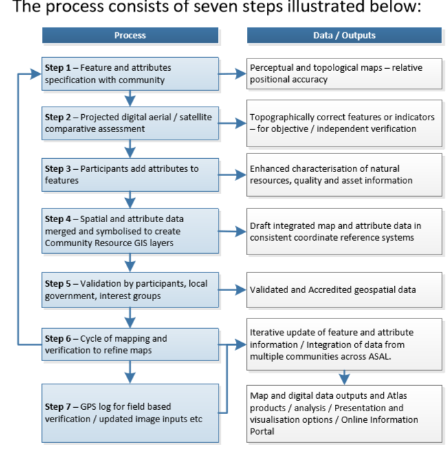
Description:
Participatory mapping of community resources has seven steps, which can be summarised under the main groupings of: consultations with the community where key features are identified and mapped on paper; digitization of community identified points by GIS specialists; processing of the data where community identified attributes are incorporated into the data; and feedback sessions for community validation and verification.
Author:
Ibrahim Jarso
3.4 Decision-making on the selection of SLM Technology/ Technologies
Specify who decided on the selection of the Technology/ Technologies to be implemented:
- all relevant actors, as part of a participatory approach
Explain:
The process requires inputs from all the relevant stakeholders. The community provide local knowledge of the features, GIS specialists provide technical expertise and the other local stakeholders provide their knowledge and experience of working in the communities for many years.
Specify on what basis decisions were made:
- personal experience and opinions (undocumented)
4. Technical support, capacity building, and knowledge management
4.1 Capacity building/ training
Was training provided to land users/ other stakeholders?
Yes
Specify who was trained:
- land users
- field staff/ advisers
If relevant, specify gender, age, status, ethnicity, etc.
5 persons trained- One from County Government (Planning Unit), Two from National government (National Drought Management Authority and Kenya Meteorological Department (KMD)) and Two representative of Local NGOs (RAP and MID-P)
Form of training:
- on-the-job
- courses
Subjects covered:
Participatory GIS mapping techniquesInput of data using different platformsUse of GPS devicesValidation of dataData management
Comments:
The training was well done with seminars and practical sessions
4.2 Advisory service
Do land users have access to an advisory service?
Yes
Specify whether advisory service is provided:
- on land users' fields
Describe/ comments:
practical sessions were provided in the field and with communities
4.3 Institution strengthening (organizational development)
Have institutions been established or strengthened through the Approach?
- yes, moderately
Specify the level(s) at which institutions have been strengthened or established:
- local
Describe institution, roles and responsibilities, members, etc.
Local institutions were able to use the maps to advocate for improved planning.
Specify type of support:
- capacity building/ training
Give further details:
Courses/trainings were provided
4.4 Monitoring and evaluation
Is monitoring and evaluation part of the Approach?
Yes
Comments:
inputs were monitored
If yes, is this documentation intended to be used for monitoring and evaluation?
Yes
Comments:
It was also used to mapped investments that were done to improve community livelihoods
4.5 Research
Was research part of the Approach?
Yes
Specify topics:
- ecology
Give further details and indicate who did the research:
Research on vegetation patterns in Isiolo’s rangelands were conducted by the University of Nairobi's Department of Land and Resource Management.
5. Financing and external material support
5.1 Annual budget for the SLM component of the Approach
If precise annual budget is not known, indicate range:
- 10,000-100,000
Comments (e.g. main sources of funding/ major donors):
The approach was supported by RAP and IIED under the Adaptation Consortium with funding from UK's Department for International Development (DfID). The budget is used to convene sub-county level meetings and trainings sessions. Many of the participants costs and preparation costs are not covered.
5.2 Financial/ material support provided to land users
Did land users receive financial/ material support for implementing the Technology/ Technologies?
No
5.3 Subsidies for specific inputs (including labour)
- labour
| To which extent | Specify subsidies |
|---|---|
| fully financed | Community meetings were supported by the actors in the project (RAP, IIED and Adaptation Consortium). |
- equipment
| Specify which inputs were subsidised | To which extent | Specify subsidies |
|---|---|---|
| machinery | fully financed | Machinery used in the approach was purchased by the actors involved. |
| tools | Tools used in the approach were purchased by the actors involved. | |
If labour by land users was a substantial input, was it:
- voluntary
Comments:
Communities provided the local knowledge to support the approach.
5.4 Credit
Was credit provided under the Approach for SLM activities?
No
6. Impact analysis and concluding statements
6.1 Impacts of the Approach
Did the Approach empower local land users, improve stakeholder participation?
- No
- Yes, little
- Yes, moderately
- Yes, greatly
Yes, the approach strengthens community rights and management of resources.
Did the Approach enable evidence-based decision-making?
- No
- Yes, little
- Yes, moderately
- Yes, greatly
Yes greatly – provided databases that did not previously exist.
Did the Approach help land users to implement and maintain SLM Technologies?
- No
- Yes, little
- Yes, moderately
- Yes, greatly
Strengthened the traditional system of management of land.
Did the Approach improve coordination and cost-effective implementation of SLM?
- No
- Yes, little
- Yes, moderately
- Yes, greatly
Improved coordination among the partners and enabled monitoring of resource conditions.
Did the Approach improve knowledge and capacities of land users to implement SLM?
- No
- Yes, little
- Yes, moderately
- Yes, greatly
The technology provided digitized observation of resources, and communities realised their wealth of their resources.
Did the Approach improve knowledge and capacities of other stakeholders?
- No
- Yes, little
- Yes, moderately
- Yes, greatly
The Community resource atlas of Isiolo County has been online since July 2015.
Yes greatly, the Approach made local institutions stronger and enhanced their collaboration and data sharing.
Did the Approach mitigate conflicts?
- No
- Yes, little
- Yes, moderately
- Yes, greatly
The Approach mapped conflict hotspots and improved the process of conflict resolution and analysis.
Did the Approach improve gender equality and empower women and girls?
- No
- Yes, little
- Yes, moderately
- Yes, greatly
The process also engaged women in gathering local knowledge of resources and they made a very considerable contribution to the work.
Did the Approach encourage young people/ the next generation of land users to engage in SLM?
- No
- Yes, little
- Yes, moderately
- Yes, greatly
The use of GIS fascinated young people and they felt attracted to the process.
Did the Approach improve issues of land tenure/ user rights that hindered implementation of SLM Technologies?
- No
- Yes, little
- Yes, moderately
- Yes, greatly
The approach guided use of land and also strengthened communities ownership and rights over their land and their available resources.
Did the Approach lead to improved access to water and sanitation?
- No
- Yes, little
- Yes, moderately
- Yes, greatly
The approach guided water investments in the community lands and improved placement of water infrastructure.
Did the Approach lead to more sustainable use/ sources of energy?
- No
- Yes, little
- Yes, moderately
- Yes, greatly
The approach mapped boreholes, and the energy used to extract water from them, as well as encouraging use of clean and green energy.
Did the Approach improve the capacity of the land users to adapt to climate changes/ extremes and mitigate climate related disasters?
- No
- Yes, little
- Yes, moderately
- Yes, greatly
The approach concretized the community land use plans and guided proper use of their pasture and water - enhancing the community's capacity to adapt to climate related disasters of drought and floods.
6.2 Main motivation of land users to implement SLM
- increased production
The Approach improved planning and management of resources leading to increased productivity
- reduced land degradation
Mapping of Land use plans helped in reducing land degradation.Participatory Mapping Approach was used by International Union for Conservation of Nature (IUCN) to map out degaraded lands in the County and targetted interventions were undertaken with Dedha elders.
- reduced risk of disasters
The approach allowed the communities to plan and prepare before disasters happen by identifying fall back areas and mapping them.Flood prone areas, Drought reserves and Conflict hotspots were mapped and deliberate interventions undertaken on addressing this.
- rules and regulations (fines)/ enforcement
The Approach developed Maps which guided the enforcement of the traditional rules and regulations of accessing pasture and water during specific seasons.
- environmental consciousness
The approach mapped key environmental resources like non-gazette forests with opportunity to enhance protection and conservation
- enhanced SLM knowledge and skills
Supported the traditional systems of management of natural resources
- conflict mitigation
The approach mapped the conflict hotspots in the county with intention to resolve or mitigate conflicts
6.3 Sustainability of Approach activities
Can the land users sustain what has been implemented through the Approach (without external support)?
- uncertain
If no or uncertain, specify and comment:
The approach was implemented with support from donors and county government. Although in theory, it could be possible for resource users to auto-finance the Approach, this has not ever happened previously, and many of the resource users are not wealthy. Support is available for devolved development planning and mapping, but as yet this has not been assigned to participatory resource mapping.
6.4 Strengths/ advantages of the Approach
| Strengths/ advantages/ opportunities in the land user’s view |
|---|
| It is a promising new approach that builds on the legitimacy of local/indigenous knowledge, and enables the county government to fulfil its mandate of undertaking participatory planning with communities. |
| GIS technology helps in the acceptance of the approach by many land users. |
| The mobililty of the technology can provide an opportunity for all community members to add features as they come up |
| Strengths/ advantages/ opportunities in the compiler’s or other key resource person’s view |
|---|
| It is a user friendly approach accepted and recognized by Isiolo pastoralists for mapping their rangeland resources. |
| It provides an opportunity to map all investments of development partners in the county and avoid duplication of projects. |
| It is a powerful tool for communication and advocacy for community land rights. |
6.5 Weaknesses/ disadvantages of the Approach and ways of overcoming them
| Weaknesses/ disadvantages/ risks in the land user’s view | How can they be overcome? |
|---|---|
| It requires time and commitment from community members and county officers. | Systematic use of media (e.g. radio, websites, etc) to publicize the approach and its importance to the community. |
| It is difficult for illiterate community members to fully engage with the approach and make meaningful contributions. | Provide local translations and interpretation as well as producing good visual maps. |
| Weaknesses/ disadvantages/ risks in the compiler’s or other key resource person’s view | How can they be overcome? |
|---|---|
| There is a need for continuous updating | Engage local universities and students. |
| Observation of key features and resources are sometimes obscured by clouds and thus mapping precision is affected. | Ground truthing visits and observations need to be undertaken to improve precision. |
| Lack of legislation to support and enforce the use of the approach. | Formulate legislation to support enforcement. |
7. References and links
7.1 Methods/ sources of information
- field visits, field surveys
Made 2 field visits in Kinna and Garbatulla Wards, engaged 20 community members
- interviews with land users
20 community members and 3 community based organization representatives
- interviews with SLM specialists/ experts
Engaged 2 staff of MID-P and 2 staff of RAP
- compilation from reports and other existing documentation
used Community Resource Mapping and Validation reports and Isiolo Community Resource Atlas 2015
7.2 References to available publications
Title, author, year, ISBN:
Participatory Mapping using Digital Earth Tools, Imagery and Open Source GIS in the drylands of Kenya and Tanzania by Chris Hill, Tom Rowley, Homme Zwaagstra, Andrew Harfoot and Mike Clark
Available from where? Costs?
Ada Consortium Website
7.3 Links to relevant information which is available online
Title/ description:
Resource Atlas of Isiolo County, Kenya
URL:
pubs.iied.org/pdfs/G03984.pdf
Links and modules
Expand all Collapse allLinks
No links
Modules
No modules