Road runoff management - Nyeri [Kenya]
- Creation:
- Update:
- Compiler: James Gatero Njuki
- Editor: –
- Reviewers: David Streiff, Alexandra Gavilano
MRP - soil conservation pilot project
technologies_1094 - Kenya
View sections
Expand all Collapse all1. General information
1.2 Contact details of resource persons and institutions involved in the assessment and documentation of the Technology
Key resource person(s)
State employee:
1.3 Conditions regarding the use of data documented through WOCAT
The compiler and key resource person(s) accept the conditions regarding the use of data documented through WOCAT:
Yes
2. Description of the SLM Technology
2.1 Short description of the Technology
Definition of the Technology:
management of runoff water on the road and its environment to reduce land degradation
2.2 Detailed description of the Technology
Description:
It encompasses agronomic, vegetative, structural and management aspects to minimise land degradation within the road catchment and its environment using participatory methods. The purpose of the technology was to improve on the managent of water from the road so that it does not cause degradation. Establishment and maintenance of the technology was done by the local community bordering the roads.
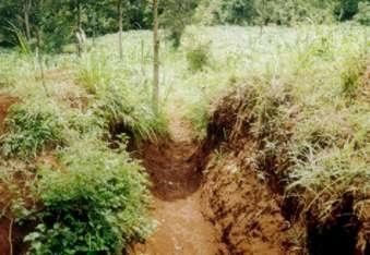
2.3 Photos of the Technology
Media Gallery
2.5 Country/ region/ locations where the Technology has been applied and which are covered by this assessment
Country:
Kenya
Region/ State/ Province:
Central
Specify the spread of the Technology:
- evenly spread over an area
If precise area is not known, indicate approximate area covered:
- < 0.1 km2 (10 ha)
Comments:
the area covered depend on the area of the road. In total the technology was duplicated in roads totalling about 33 kilometres
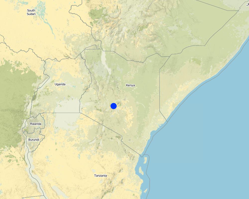
Map
×2.6 Date of implementation
If precise year is not known, indicate approximate date:
- less than 10 years ago (recently)
2.7 Introduction of the Technology
Specify how the Technology was introduced:
- through land users' innovation
Comments (type of project, etc.):
SWC specialists and land users
3. Classification of the SLM Technology
3.1 Main purpose(s) of the Technology
- reduce, prevent, restore land degradation
3.2 Current land use type(s) where the Technology is applied

Cropland
- Annual cropping
Number of growing seasons per year:
- 2
Specify:
Longest growing period in days: 120Longest growing period from month to month: Mar - MaySecond longest growing period in days: 90Second longest growing period from month to month: Oct - Dec

Settlements, infrastructure
- Traffic: roads, railways
Comments:
Major land use problems (compiler’s opinion): Declining soil fertility and soil erosion, land subdivision leading to small parcels of land
Major land use problems (land users’ perception): Marketing/pricing of farm produce, high costs of inputs and lack of credit
Grazingland comments: stall feeding is the most common grazing system as there are no delienated portions for grazing , due to the small holdings
Type of grazing system comments: stall feeding is the most common grazing system as there are no delienated portions for grazing , due to the small holdings
3.4 Water supply
Water supply for the land on which the Technology is applied:
- rainfed
3.5 SLM group to which the Technology belongs
- water diversion and drainage
3.6 SLM measures comprising the Technology

structural measures
- S4: Level ditches, pits
Comments:
Main measures: structural measures
Secondary measures: agronomic measures, vegetative measures, management measures
Type of agronomic measures: contour ridging
3.7 Main types of land degradation addressed by the Technology

soil erosion by water
- Wt: loss of topsoil/ surface erosion
- Wg: gully erosion/ gullying
- Wo: offsite degradation effects

chemical soil deterioration
- Cn: fertility decline and reduced organic matter content (not caused by erosion)
Comments:
Main type of degradation addressed: Wt: loss of topsoil / surface erosion, Wg: gully erosion / gullying, Wo: offsite degradation effects
Secondary types of degradation addressed: Cn: fertility decline and reduced organic matter content
Main causes of degradation: other human induced causes (specify) (road surface & Agricultural causes), roads
Secondary causes of degradation: education, access to knowledge and support services (Lack of knowledge), Lack of enforcement of legislat./authority
3.8 Prevention, reduction, or restoration of land degradation
Specify the goal of the Technology with regard to land degradation:
- reduce land degradation
4. Technical specifications, implementation activities, inputs, and costs
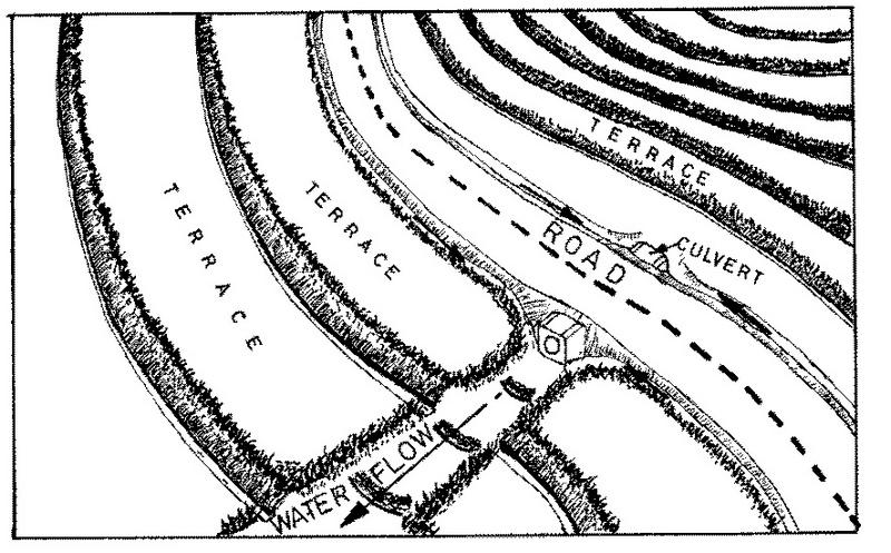
4.1 Technical drawing of the Technology
Technical specifications (related to technical drawing):
Technical knowledge required for field staff / advisors: moderate
Main technical functions: control of dispersed runoff: impede / retard, control of concentrated runoff: retain / trap, control of concentrated runoff: impede / retard, control of concentrated runoff: drain / divert
Secondary technical functions: reduction of slope length, increase in organic matter, increase of infiltration
Grass species: napier grass
Slope (which determines the spacing indicated above): 0.00%
Construction material (stone): for scour checks in the waterway
Construction material (wood): small posts for scour checks
Construction material (other): grass, brush wood, live vegetative material
Lateral gradient along the structure: 8%
Vegetation is used for stabilisation of structures.
Change of land use type: exclusion of land under waterway
4.2 General information regarding the calculation of inputs and costs
other/ national currency (specify):
Kenyan Shilling
If relevant, indicate exchange rate from USD to local currency (e.g. 1 USD = 79.9 Brazilian Real): 1 USD =:
33.0
Indicate average wage cost of hired labour per day:
0.96
4.3 Establishment activities
| Activity | Timing (season) | |
|---|---|---|
| 1. | planting napier grass cuttings | after first rains |
| 2. | establish scour checks | on set of rains |
| 3. | excavation | dry spell |
| 4. | planting grass for stabilisation | on set of rains |
4.4 Costs and inputs needed for establishment
Comments:
Duration of establishment phase: 24 month(s)
4.5 Maintenance/ recurrent activities
| Activity | Timing/ frequency | |
|---|---|---|
| 1. | contour ridging | dry season / beginning of season |
| 2. | weeding | dry spell /once per season |
| 3. | desilting channel | dry season/each cropping season |
| 4. | gapping the grass | wet season/each cropping season |
| 5. | slashing grass in channel | wet season/each cropping season |
4.6 Costs and inputs needed for maintenance/ recurrent activities (per year)
Comments:
For the length of the waterway in metres. The length of the structure was kept constant
4.7 Most important factors affecting the costs
Describe the most determinate factors affecting the costs:
The general ground slope determines the cost of the structures and the distance of the safe discharge point from the road
5. Natural and human environment
5.1 Climate
Annual rainfall
- < 250 mm
- 251-500 mm
- 501-750 mm
- 751-1,000 mm
- 1,001-1,500 mm
- 1,501-2,000 mm
- 2,001-3,000 mm
- 3,001-4,000 mm
- > 4,000 mm
Agro-climatic zone
- humid
- sub-humid
Thermal climate class: tropics
5.2 Topography
Slopes on average:
- flat (0-2%)
- gentle (3-5%)
- moderate (6-10%)
- rolling (11-15%)
- hilly (16-30%)
- steep (31-60%)
- very steep (>60%)
Landforms:
- plateau/plains
- ridges
- mountain slopes
- hill slopes
- footslopes
- valley floors
Altitudinal zone:
- 0-100 m a.s.l.
- 101-500 m a.s.l.
- 501-1,000 m a.s.l.
- 1,001-1,500 m a.s.l.
- 1,501-2,000 m a.s.l.
- 2,001-2,500 m a.s.l.
- 2,501-3,000 m a.s.l.
- 3,001-4,000 m a.s.l.
- > 4,000 m a.s.l.
Comments and further specifications on topography:
Landforms: Also valley floors
Slopes on average: Also moderate
5.3 Soils
Soil depth on average:
- very shallow (0-20 cm)
- shallow (21-50 cm)
- moderately deep (51-80 cm)
- deep (81-120 cm)
- very deep (> 120 cm)
Soil texture (topsoil):
- medium (loamy, silty)
Topsoil organic matter:
- medium (1-3%)
If available, attach full soil description or specify the available information, e.g. soil type, soil PH/ acidity, Cation Exchange Capacity, nitrogen, salinity etc.
Soil fertility is medium-high
Soil drainage / infiltration is good
Soil water storage capacity is medium-high
5.6 Characteristics of land users applying the Technology
Off-farm income:
- less than 10% of all income
Relative level of wealth:
- poor
- average
Level of mechanization:
- manual work
Indicate other relevant characteristics of the land users:
Population density: 200-500 persons/km2
Annual population growth: 3% - 4%
5% of the land users are rich and own 10% of the land.
50% of the land users are average wealthy and own 70% of the land.
25% of the land users are poor and own 15% of the land.
20% of the land users are poor and own 5% of the land.
Off-farm income specification: mainly from employment in the nearby urban areas
Level of mechanization: With hand tools
5.8 Land ownership, land use rights, and water use rights
Land ownership:
- individual, titled
Land use rights:
- individual
6. Impacts and concluding statements
6.1 On-site impacts the Technology has shown
Ecological impacts
Water cycle/ runoff
surface runoff
Quantity before SLM:
50
Quantity after SLM:
20
Soil
soil loss
Quantity before SLM:
25
Quantity after SLM:
15
6.4 Cost-benefit analysis
How do the benefits compare with the establishment costs (from land users’ perspective)?
Short-term returns:
slightly positive
Long-term returns:
positive
How do the benefits compare with the maintenance/ recurrent costs (from land users' perspective)?
Short-term returns:
slightly positive
Long-term returns:
neutral/ balanced
6.5 Adoption of the Technology
- > 50%
If available, quantify (no. of households and/ or area covered):
210 households in an area of 10 ha
Of all those who have adopted the Technology, how many did so spontaneously, i.e. without receiving any material incentives/ payments?
- 0-10%
Comments:
20% of land user families have adopted the Technology with external material support
200 land user families have adopted the Technology with external material support
Comments on acceptance with external material support: estimates
5% of land user families have adopted the Technology without any external material support
10 land user families have adopted the Technology without any external material support
Comments on spontaneous adoption: estimates
There is no trend towards spontaneous adoption of the Technology
Comments on adoption trend: technology adoption not spontaneous because of dependency on material support from donor
7. References and links
7.1 Methods/ sources of information
7.2 References to available publications
Title, author, year, ISBN:
farm management handbook of Kenya. 1983.
Available from where? Costs?
SWC branch, MoA, Nairobi
Title, author, year, ISBN:
minor roads soil conservation project. Final report. 1992.
Available from where? Costs?
Ministry of Public Works. Nairobi.
Links and modules
Expand all Collapse allLinks
No links
Modules
No modules