Small Farm Reservoir (SFR) [Philippines]
- Creation:
- Update:
- Compiler: Philippine Overview of Conservation Approaches and Technologies
- Editor: –
- Reviewers: Deborah Niggli, Alexandra Gavilano
Tabon
technologies_1102 - Philippines
View sections
Expand all Collapse all1. General information
1.2 Contact details of resource persons and institutions involved in the assessment and documentation of the Technology
SLM specialist:
SANDOVAL TERESITA
Bureau of Soils and Water Management
Philippines
SLM specialist:
GICANA DOLORES MAE
Bureau of Soils and Water Management
Philippines
1.3 Conditions regarding the use of data documented through WOCAT
The compiler and key resource person(s) accept the conditions regarding the use of data documented through WOCAT:
Yes
1.4 Declaration on sustainability of the described Technology
Is the Technology described here problematic with regard to land degradation, so that it cannot be declared a sustainable land management technology?
No
2. Description of the SLM Technology
2.1 Short description of the Technology
Definition of the Technology:
The Small Farm Rerservoir is an earth dam structure used to trap harvest and store rainfall and water runoff.
2.2 Detailed description of the Technology
Description:
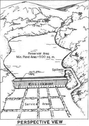
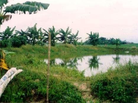
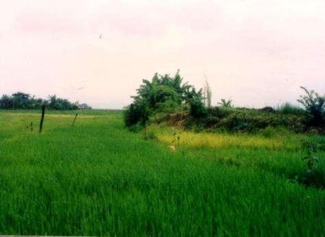
The small farm reservoir (SFR) is a small water impounding earth dam structure to collect rainfall and runoff, designed for use in a single farm, and typically has an area of about 300-2,000 square meters. The embankment height above ground level is less than 4 meters. It can be easily constructed with a bulldozer or manual labor. Irrigation is done with PVC siphon pipes or pumps. SFR is used in rainfed-growing areas to provide supplemental irrigation to a wet season crop and partial irrigation to a dry season crop. Aside from irrigation and aquaculture, water in the reservoir could also be used for small scale livestock watering, wallowing areas for animals, e.g. ducks and picnic ground.
2.3 Photos of the Technology
Media Gallery
2.5 Country/ region/ locations where the Technology has been applied and which are covered by this assessment
Country:
Philippines
Further specification of location:
Pangasinan, Nueva Ecija, Tarlac, Isabela, Bulacan, Ilocos Norte
Specify the spread of the Technology:
- evenly spread over an area
If precise area is not known, indicate approximate area covered:
- 100-1,000 km2
Comments:
Total area covered by the SLM Technology is 8884 m2.
The Department of Agriculture (DA) thru the Bureau of Soils and Water Management (BSWM) and different DA-Regional Field Units has embarked on intensive and fast-track implementation of the technology to conserve rain water during wet season to prevent flooding and to provide supplemental irrigation during dry season.
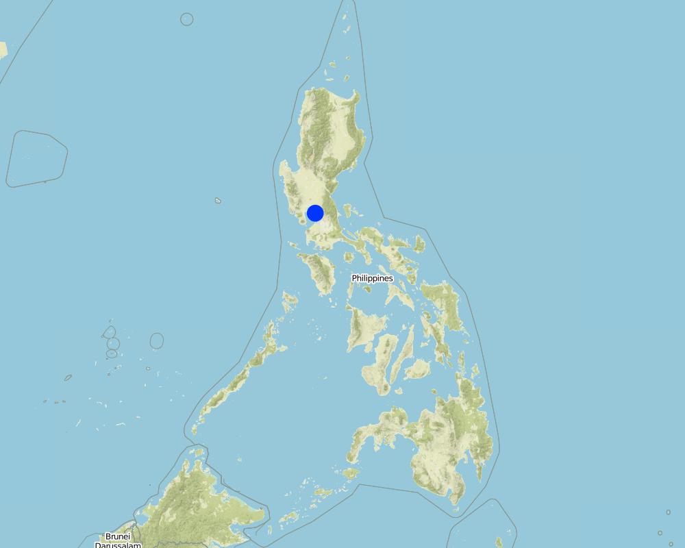
Map
×2.6 Date of implementation
If precise year is not known, indicate approximate date:
- less than 10 years ago (recently)
2.7 Introduction of the Technology
Specify how the Technology was introduced:
- through projects/ external interventions
Comments (type of project, etc.):
From other areas with similar (areas where runoff can be collected and impounded and used for supplementary irrigation).
3. Classification of the SLM Technology
3.1 Main purpose(s) of the Technology
- improve production
- reduce, prevent, restore land degradation
3.2 Current land use type(s) where the Technology is applied

Cropland
- Annual cropping
Number of growing seasons per year:
- 2
Specify:
Longest growing period in days: 180, Longest growing period from month to month: May - Oct; Second longest growing period in days: 120, Second longest growing period from month to month: Nov - Feb
Comments:
Major land use problems (compiler’s opinion): Very low yield of any crop due to inadequate moisture to sustain crop growth.
Major land use problems (land users’ perception): Unpredictable weather condition or occurrence of extreme climatic condition (La Nina or El Nino) constrained yield improvement.
3.5 SLM group to which the Technology belongs
- water harvesting
- irrigation management (incl. water supply, drainage)
- water diversion and drainage
3.6 SLM measures comprising the Technology

agronomic measures
- A3: Soil surface treatment
- A5: Seed management, improved varieties
A3: Differentiate tillage systems:
A 3.2: Reduced tillage (> 30% soil cover)

structural measures
- S1: Terraces
Comments:
Type of agronomic measures: mixed cropping / intercropping, legume inter-planting, rotations / fallows, minimum tillage
3.8 Prevention, reduction, or restoration of land degradation
Specify the goal of the Technology with regard to land degradation:
- prevent land degradation
- restore/ rehabilitate severely degraded land
4. Technical specifications, implementation activities, inputs, and costs
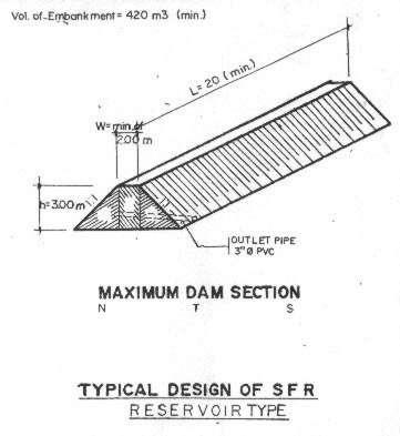
4.1 Technical drawing of the Technology
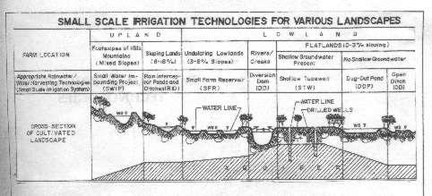
Technical specifications (related to technical drawing):
Uses of Small Farm Reservoir (SFR) system
Technical knowledge required for field staff / advisors: moderate
Technical knowledge required for land users: moderate
Main technical functions: control of dispersed runoff: retain / trap, control of concentrated runoff: retain / trap, water harvesting / increase water supply
Rotations / fallows
Material/ species: rice, corn, peanut
Minimum tillage
Material/ species: minimum tillage
Construction material (earth): The structure on earth dam
Author:
Bureau of Soils & Water Manage
4.2 General information regarding the calculation of inputs and costs
other/ national currency (specify):
Phil. Peso
If relevant, indicate exchange rate from USD to local currency (e.g. 1 USD = 79.9 Brazilian Real): 1 USD =:
43.0
Indicate average wage cost of hired labour per day:
4.00
4.3 Establishment activities
| Activity | Timing (season) | |
|---|---|---|
| 1. | 1. Cleaning | onset of rains (May-June) |
| 2. | 2. Layouting/staking | onset of rains |
| 3. | 3. Rotovating or plowing | |
| 4. | 4. Basal fertilization | |
| 5. | 5. Planting | |
| 6. | 1. Site Investigation,Examination of soil profile | Start of Project |
| 7. | 2. Orienting the bulldozer operator on one technique of embankment and clearing the staked-out area | |
| 8. | 3. Scapping the top soil | |
| 9. | 3. Embankment construction |
4.5 Maintenance/ recurrent activities
| Activity | Timing/ frequency | |
|---|---|---|
| 1. | 1. Irrigation | |
| 2. | 2. Minimum tillage | |
| 3. | 3. Planting | |
| 4. | 1. Weeding | /Monthly |
| 5. | 2. Fertilization | |
| 6. | 3. Irrigation | dry season /weekly |
| 7. | 1. Canal maintenance | as need arises |
| 8. | 2. Watershed protection and maintenance | continuing |
4.7 Most important factors affecting the costs
Describe the most determinate factors affecting the costs:
The availability of bulldozers in the site and access roads adds substantially to the cost.
5. Natural and human environment
5.1 Climate
Annual rainfall
- < 250 mm
- 251-500 mm
- 501-750 mm
- 751-1,000 mm
- 1,001-1,500 mm
- 1,501-2,000 mm
- 2,001-3,000 mm
- 3,001-4,000 mm
- > 4,000 mm
Agro-climatic zone
- sub-humid
Thermal climate class: tropics
5.2 Topography
Slopes on average:
- flat (0-2%)
- gentle (3-5%)
- moderate (6-10%)
- rolling (11-15%)
- hilly (16-30%)
- steep (31-60%)
- very steep (>60%)
Landforms:
- plateau/plains
- ridges
- mountain slopes
- hill slopes
- footslopes
- valley floors
Altitudinal zone:
- 0-100 m a.s.l.
- 101-500 m a.s.l.
- 501-1,000 m a.s.l.
- 1,001-1,500 m a.s.l.
- 1,501-2,000 m a.s.l.
- 2,001-2,500 m a.s.l.
- 2,501-3,000 m a.s.l.
- 3,001-4,000 m a.s.l.
- > 4,000 m a.s.l.
5.3 Soils
Soil depth on average:
- very shallow (0-20 cm)
- shallow (21-50 cm)
- moderately deep (51-80 cm)
- deep (81-120 cm)
- very deep (> 120 cm)
Soil texture (topsoil):
- medium (loamy, silty)
Topsoil organic matter:
- medium (1-3%)
- low (<1%)
5.6 Characteristics of land users applying the Technology
Market orientation of production system:
- subsistence (self-supply)
- mixed (subsistence/ commercial)
Off-farm income:
- 10-50% of all income
Relative level of wealth:
- poor
- average
Level of mechanization:
- animal traction
Indicate other relevant characteristics of the land users:
Population density: 10-50 persons/km2
5% of the land users are very rich and own 25% of the land.
10% of the land users are rich and own 25% of the land.
50% of the land users are average wealthy and own 40% of the land.
30% of the land users are poor and own 5% of the land.
5.7 Average area of land used by land users applying the Technology
- < 0.5 ha
- 0.5-1 ha
- 1-2 ha
- 2-5 ha
- 5-15 ha
- 15-50 ha
- 50-100 ha
- 100-500 ha
- 500-1,000 ha
- 1,000-10,000 ha
- > 10,000 ha
5.8 Land ownership, land use rights, and water use rights
Land ownership:
- individual, not titled
- individual, titled
Land use rights:
- open access (unorganized)
- individual
6. Impacts and concluding statements
6.1 On-site impacts the Technology has shown
Socio-economic impacts
Production
crop production
Comments/ specify:
rice production
wood production
production area
Other socio-economic impacts
Fish production
Comments/ specify:
fish culture
Socio-cultural impacts
recreational opportunities
Comments/ specify:
picnic ground
community institutions
Comments/ specify:
farmers are organized in Association
SLM/ land degradation knowledge
Comments/ specify:
including soil fertility management
Ecological impacts
Soil
soil moisture
soil cover
Biodiversity: vegetation, animals
plant diversity
Other ecological impacts
Soil fertility
Comments/ specify:
have second crop
6.2 Off-site impacts the Technology has shown
water availability
Comments/ specify:
increased ground water recharge
downstream flooding
6.7 Strengths/ advantages/ opportunities of the Technology
| Strengths/ advantages/ opportunities in the compiler’s or other key resource person’s view |
|---|
| Individual farmers can own one or a number SFR, big areas of rainfed lowland areas are available during the dry season, SFR has multiple purposes as irrigation supplement, fish production, and recreation |
7. References and links
7.1 Methods/ sources of information
- field visits, field surveys
- interviews with land users
When were the data compiled (in the field)?
30/08/2000
7.2 References to available publications
Title, author, year, ISBN:
Manual of Small Farm Reservoir (SFR). 1993.
Available from where? Costs?
Philippine Council for Agriculture, Forestry and Natural Resources Research and Dev't (PCARRD), Technology and Application Institute (TAPI), Department of Science and Technology (DOST)
Title, author, year, ISBN:
The Philippine Agriculturist, Vol. 80 No. 3 &4/Romeo V. Labios, Virgilio Villancio, Jocelyn D. Labios, Artemio Salazar and Romeo E. delos Santos. July-Dec 1997.
Available from where? Costs?
Publication Office, College of Agricultur, University of the Philipines Los Baños
Links and modules
Expand all Collapse allLinks
No links
Modules
No modules