Natural revegetation [Spain]
- Creation:
- Update:
- Compiler: Artemi Cerda
- Editor: –
- Reviewers: Fabian Ottiger, Alexandra Gavilano
Revegetación natural
technologies_1265 - Spain
View sections
Expand all Collapse all1. General information
1.2 Contact details of resource persons and institutions involved in the assessment and documentation of the Technology
Name of the institution(s) which facilitated the documentation/ evaluation of the Technology (if relevant)
Universidad de Valencia (Universidad de Valencia) - Spain1.3 Conditions regarding the use of data documented through WOCAT
When were the data compiled (in the field)?
08/06/2015
The compiler and key resource person(s) accept the conditions regarding the use of data documented through WOCAT:
Yes
1.4 Declaration on sustainability of the described Technology
Is the Technology described here problematic with regard to land degradation, so that it cannot be declared a sustainable land management technology?
No
2. Description of the SLM Technology
2.1 Short description of the Technology
Definition of the Technology:
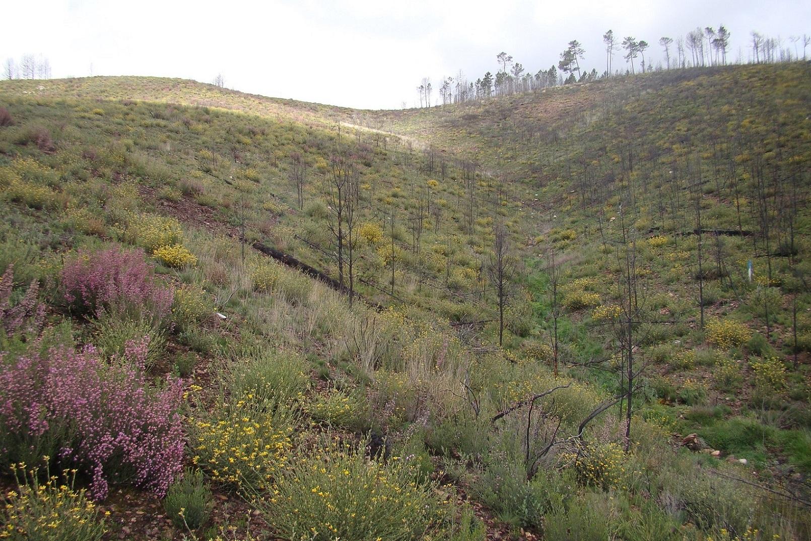
Based on post-fire assessment, native vegetation will regenerate by natural processes giving the right conditions.
2.2 Detailed description of the Technology
Description:
A wildfire is expected for the summer 2015 in the Caroig mountain range. The area was afforested with Aleppo pines during the 20th century and nowadays the landscape is composed by mature Aleppo pines at different stages of development and shrub vegetation in the understorey.
The research team of the University of Valencia will implement an experiment based on the sediment fences technique to capture and measure post-fire soil losses in a natural burned landscape.
Purpose of the Technology: The post-fire environment will be developed in a natural process. Burned logs, trees and ashes will promote soil cover and together with the lack of intervention with heavy machinery, is expected to decrease soil erosion by increasing roughness, decrease of runoff velocity, and increase water infiltration.
Establishment / maintenance activities and inputs: There are no maintenance activities since the main purpose is the natural re-vegetation.
Natural / human environment: The Aleppo pine trees in the region are typically planted as monoculture for wood production. The landscape reflects a long history of intense land management, with a mosaic of (semi-)natural and man-made agricultural (terraces) and afforested lands. Since the 1970´s, however, wildfires have increased dramatically in frequency and extent, driven primarily by socio-economic changes.
2.3 Photos of the Technology
Media Gallery
2.5 Country/ region/ locations where the Technology has been applied and which are covered by this assessment
Country:
Spain
Region/ State/ Province:
Spain
Further specification of location:
Valencia

Map
×3. Classification of the SLM Technology
3.2 Current land use type(s) where the Technology is applied

Forest/ woodlands
Tree plantation, afforestation:
- Monoculture local variety
- Aleppo pines
Comments:
Major land use problems (compiler’s opinion): When high fire severity, it is expected a runoff and soil erosion increase, resulting in a decrease of on-site fertility and derived off-site effects such as loss of water quality, reservoirs water volume storage, higher risk of flooding and human beings damage. When low-moderate fire severity a natural mulch will occurs and together with resproting shoots will keep low erosion rates.
Major land use problems (land users’ perception): Loss of wood resources.
Plantation forestry: no management increasing fuel load
Forest products and services: timber, fuelwood, fruits and nuts, grazing / browsing, other forest products / uses (honey, medical, etc.), nature conservation / protection, recreation / tourism, protection against natural hazards
3.4 SLM group to which the Technology belongs
- improved ground/ vegetation cover
- minimal soil disturbance
- Minimal disturbance of the eco-system
3.5 Spread of the Technology
Comments:
The application is foreseen after a wildfire
3.7 Main types of land degradation addressed by the Technology

soil erosion by water
- Wt: loss of topsoil/ surface erosion
Comments:
Main causes of degradation: soil management (monoculture plantations are prone to wildfire), deforestation / removal of natural vegetation (incl. forest fires) (forest fires), Heavy / extreme rainfall (intensity/amounts) (Post-fire high intensity rain events promotes huge soil erosion rates), droughts (Dry vegetation acts as a fuel.)
Secondary causes of degradation: crop management (annual, perennial, tree/shrub), over-exploitation of vegetation for domestic use, overgrazing, industrial activities and mining, urbanisation and infrastructure development, discharges (point contamination of water), release of airborne pollutants (urban/industry…), disturbance of water cycle (infiltration / runoff), over abstraction / excessive withdrawal of water (for irrigation, industry, etc.), change in temperature, change of seasonal rainfall, floods, population pressure (Depopulation increase fire risk), land tenure, poverty / wealth, labour availability, inputs and infrastructure: (roads, markets, distribution of water points, other, …), education, access to knowledge and support services, war and conflicts, governance / institutional
4. Technical specifications, implementation activities, inputs, and costs
4.1 Technical drawing of the Technology
Author:
González-Pelayo, Oscar, University of Valencia. Dept. of Geography. Blasco Ibañez 28. 46010. Valencia. Spain
4.2 Technical specifications/ explanations of technical drawing
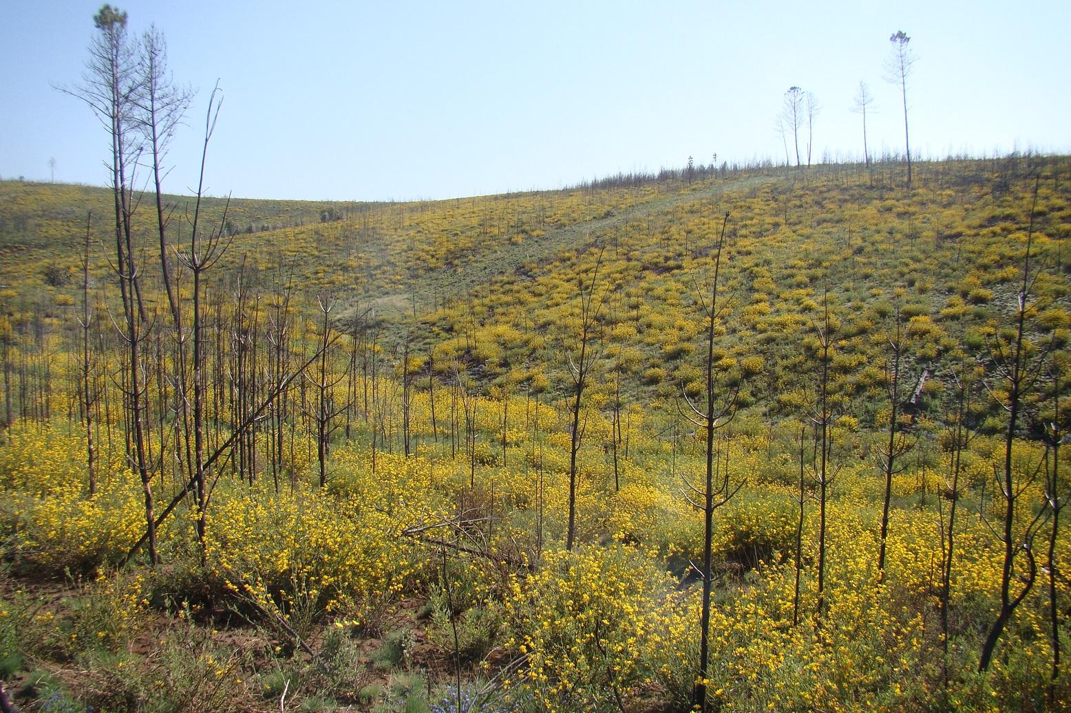
Natural revegetation. Shrubs resprouting 8 months after a wildfire.
Location: Valencia. Spain
Date: 05/04/2013
Technical knowledge required for field staff / advisors: moderate (led the landscape to revegetate based on fire severity indicators)
Technical knowledge required for land users: low
Main technical functions: control of raindrop splash, improvement of ground cover, increase of surface roughness, increase in organic matter, sediment retention / trapping, sediment harvesting, increase of biomass (quantity), promotion of vegetation species and varieties (quality, eg palatable fodder)
Secondary technical functions: control of dispersed runoff: retain / trap, control of dispersed runoff: impede / retard, control of concentrated runoff: retain / trap, control of concentrated runoff: impede / retard, control of concentrated runoff: drain / divert, reduction of slope angle, reduction of slope length, improvement of surface structure (crusting, sealing), improvement of topsoil structure (compaction), improvement of subsoil structure (hardpan), stabilisation of soil (eg by tree roots against land slides), increase in nutrient availability (supply, recycling,…), increase of infiltration, increase / maintain water stored in soil, increase of groundwater level / recharge of groundwater, water harvesting / increase water supply, water spreading, improvement of water quality, buffering / filtering water, reduction in wind speed, control of fires, reduction of dry material (fuel for wildfires), spatial arrangement and diversification of land use
Change of land use type: no management
Change of land use practices / intensity level: no management
Major change in timing of activities: no management
4.8 Most important factors affecting the costs
Describe the most determinate factors affecting the costs:
There is no cost because the technology to implement is keep the system as it is after a wildfire promoting the revegetation of resprouting trees and shrubs.
5. Natural and human environment
5.1 Climate
Annual rainfall
- < 250 mm
- 251-500 mm
- 501-750 mm
- 751-1,000 mm
- 1,001-1,500 mm
- 1,501-2,000 mm
- 2,001-3,000 mm
- 3,001-4,000 mm
- > 4,000 mm
Specifications/ comments on rainfall:
Mediterranean climate with concentred precipitation in february-may and september-december months. Drought from june to september
Agro-climatic zone
- sub-humid
- semi-arid
Thermal climate class: temperate (transition zone between semiarid and subhumid)
5.2 Topography
Slopes on average:
- flat (0-2%)
- gentle (3-5%)
- moderate (6-10%)
- rolling (11-15%)
- hilly (16-30%)
- steep (31-60%)
- very steep (>60%)
Landforms:
- plateau/plains
- ridges
- mountain slopes
- hill slopes
- footslopes
- valley floors
Altitudinal zone:
- 0-100 m a.s.l.
- 101-500 m a.s.l.
- 501-1,000 m a.s.l.
- 1,001-1,500 m a.s.l.
- 1,501-2,000 m a.s.l.
- 2,001-2,500 m a.s.l.
- 2,501-3,000 m a.s.l.
- 3,001-4,000 m a.s.l.
- > 4,000 m a.s.l.
Comments and further specifications on topography:
Slopes on average: Also steep (31-60%)
Landforms: Also hill slopes
Altitudinal zone: 501-1000 m a.s.l. (650-700)
5.3 Soils
Soil depth on average:
- very shallow (0-20 cm)
- shallow (21-50 cm)
- moderately deep (51-80 cm)
- deep (81-120 cm)
- very deep (> 120 cm)
Soil texture (topsoil):
- medium (loamy, silty)
Topsoil organic matter:
- high (>3%)
If available, attach full soil description or specify the available information, e.g. soil type, soil PH/ acidity, Cation Exchange Capacity, nitrogen, salinity etc.
Soil depth on average: Very shallow (Leptosol) and shallow (Cambiosol)
Soil fertility is medium
Soil drainage/infiltration is medium
Soil water storage capacity is high
5.4 Water availability and quality
Ground water table:
5-50 m
Availability of surface water:
medium
Comments and further specifications on water quality and quantity:
Availability of surface water: Medium (few permanent water courses in the area)
5.6 Characteristics of land users applying the Technology
Individuals or groups:
- groups/ community
Gender:
- women
- men
Indicate other relevant characteristics of the land users:
Land users applying the Technology are mainly common / average land users
5.7 Average area of land owned or leased by land users applying the Technology
- < 0.5 ha
- 0.5-1 ha
- 1-2 ha
- 2-5 ha
- 5-15 ha
- 15-50 ha
- 50-100 ha
- 100-500 ha
- 500-1,000 ha
- 1,000-10,000 ha
- > 10,000 ha
Is this considered small-, medium- or large-scale (referring to local context)?
- small-scale
5.9 Access to services and infrastructure
health:
- poor
- moderate
- good
education:
- poor
- moderate
- good
technical assistance:
- poor
- moderate
- good
employment (e.g. off-farm):
- poor
- moderate
- good
markets:
- poor
- moderate
- good
energy:
- poor
- moderate
- good
roads and transport:
- poor
- moderate
- good
drinking water and sanitation:
- poor
- moderate
- good
financial services:
- poor
- moderate
- good
6. Impacts and concluding statements
6.1 On-site impacts the Technology has shown
Socio-cultural impacts
SLM/ land degradation knowledge
Ecological impacts
Water cycle/ runoff
surface runoff
Soil
soil cover
soil loss
Biodiversity: vegetation, animals
pest/ disease control
6.3 Exposure and sensitivity of the Technology to gradual climate change and climate-related extremes/ disasters (as perceived by land users)
Gradual climate change
Gradual climate change
| Season | Type of climatic change/ extreme | How does the Technology cope with it? | |
|---|---|---|---|
| annual temperature | increase | not known |
Climate-related extremes (disasters)
Meteorological disasters
| How does the Technology cope with it? | |
|---|---|
| local rainstorm | not well |
| local windstorm | not known |
Climatological disasters
| How does the Technology cope with it? | |
|---|---|
| drought | not well |
Hydrological disasters
| How does the Technology cope with it? | |
|---|---|
| general (river) flood | not well |
Other climate-related consequences
Other climate-related consequences
| How does the Technology cope with it? | |
|---|---|
| reduced growing period | not known |
6.7 Strengths/ advantages/ opportunities of the Technology
| Strengths/ advantages/ opportunities in the land user’s view |
|---|
| Land users are not fully aware to leave natural revegetation as a technique. |
| Strengths/ advantages/ opportunities in the compiler’s or other key resource person’s view |
|---|
|
It is a technology easy to apply. Just left natural revegetation. How can they be sustained / enhanced? selecting appropriate areas to natural revegetations requires technical formation on post-fire effects. |
6.8 Weaknesses/ disadvantages/ risks of the Technology and ways of overcoming them
| Weaknesses/ disadvantages/ risks in the compiler’s or other key resource person’s view | How can they be overcome? |
|---|---|
| Selected areas to keep unaltered must be assessed by specialist. | Formation on post-fire mitigation and restoration techniques |
Links and modules
Expand all Collapse allLinks
No links
Modules
No modules