Conservation Agriculture in a semi-arid area [Namibia]
- Creation:
- Update:
- Compiler: Alexander Groengroeft
- Editor: –
- Reviewers: Deborah Niggli, David Streiff, Alexandra Gavilano
Lima nawa (Vambo/Rukwangali)
technologies_1297 - Namibia
View sections
Expand all Collapse all1. General information
1.2 Contact details of resource persons and institutions involved in the assessment and documentation of the Technology
SLM specialist:
Simfukwe Maxon
CEDP
SLM specialist:
Kowalski Benjamin
Germany
Name of project which facilitated the documentation/ evaluation of the Technology (if relevant)
Book project: Making sense of research for sustainable land management (GLUES)Name of project which facilitated the documentation/ evaluation of the Technology (if relevant)
The Future of Okavango (TFO / GLUES)1.3 Conditions regarding the use of data documented through WOCAT
The compiler and key resource person(s) accept the conditions regarding the use of data documented through WOCAT:
Yes
1.4 Declaration on sustainability of the described Technology
Is the Technology described here problematic with regard to land degradation, so that it cannot be declared a sustainable land management technology?
No
2. Description of the SLM Technology
2.1 Short description of the Technology
Definition of the Technology:
Conservation agriculture using permanent water-harvesting planting basins, or rip-lines and fertilizer/manure application on low fertility dryland soils.
2.2 Detailed description of the Technology
Description:
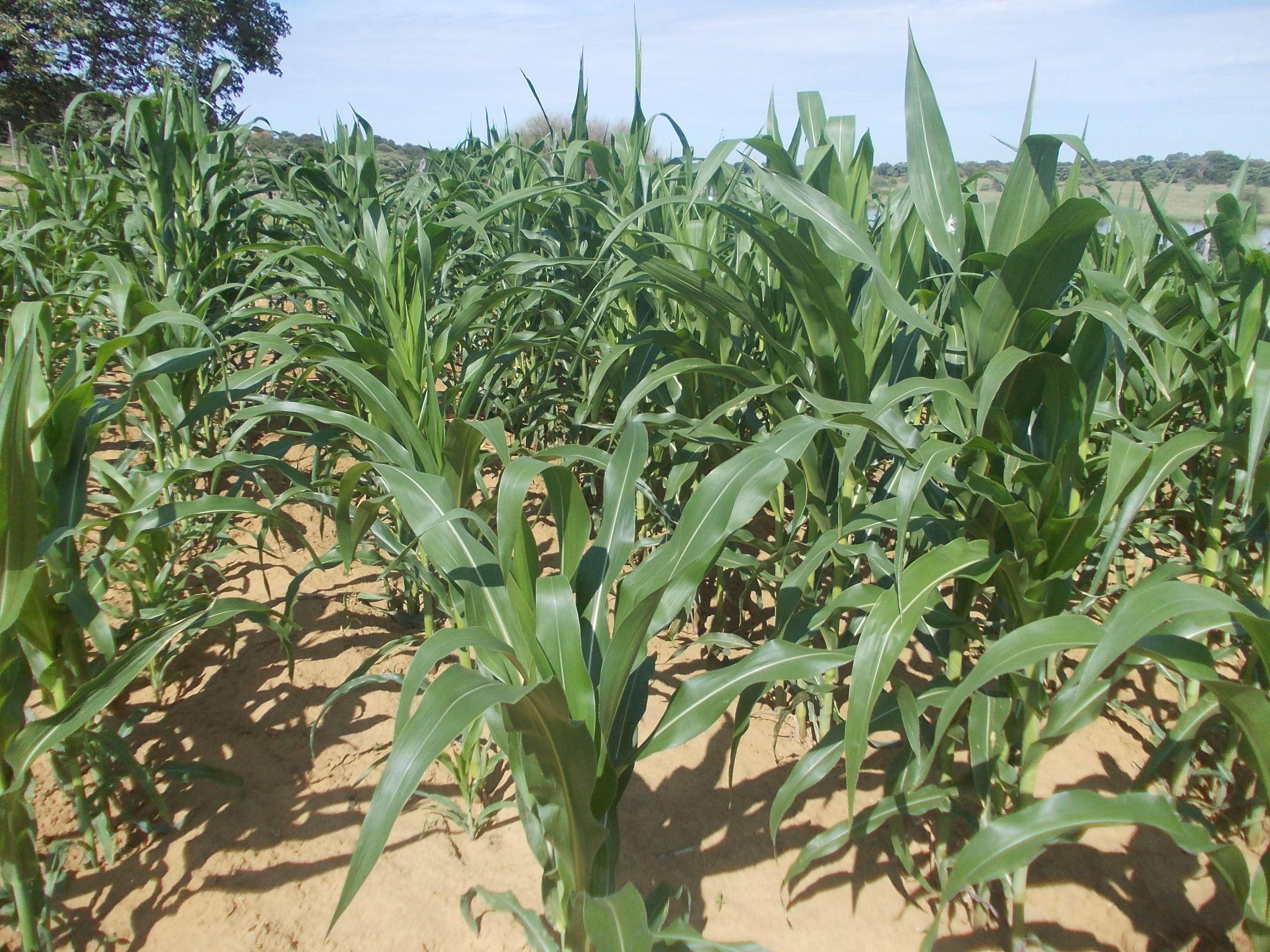
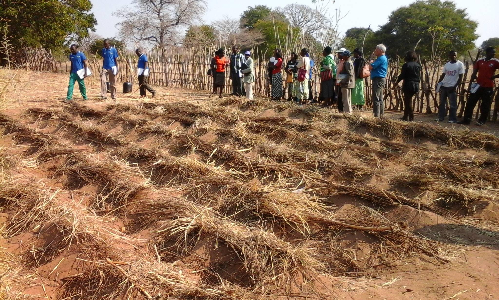
Farmers in north-eastern Namibia practice shifting/semi-permanent subsistence cropping, concentrating on pearl millet cultivation. Here, conservation agriculture (CA) was promoted to sustain and improve production and to reduce conversion of woodland to crops. CA comprises the three principles of minimum soil disturbance, permanent soil cover, and rotation. CA was tested on small plots with volunteers trained by a local NGO. The technology was characterized here by: (i) Early (pre-rains) preparation of the land with two alternative techniques; either: a) basins with a defined spacing opened by a hand hoe, with composted manure added (biochar has also been tested), or b) rip-lines prepared with oxen in lines and with manure application within the rip lines; (ii) Mulching the soil with crop residues, branches or sunnhemp, specially grown for the purpose; (iii) Protection against grazing of crop and mulch by livestock; (iv) Intercropping with vegetables or legumes. (v) Weeding.
CA has been promoted for four seasons, and now trained farmers are transferring their knowledge to others. The technology was promoted to substantially improve the low yields of traditionally practiced agriculture by improving fertility and soil structure as well as better capturing runoff. It was also aimed at avoiding further expansion of croplands into dry woodlands on low fertility arenosols. Eventually it is hoped that the well-being of local subsistence cropping communities will be improved and outmigration reduced.
Knowledge about CA comes from Zambia, where it has been has been practiced successfully for many years by small-scale farmers. A local NGO was engaged by an international project (www.future-okavango.org) which searched for volunteer farmers in the Kavango area. The first CA planting took place in 2011/12. These pioneer farmers were backstopped regularly and the number of farmers trained increased. The NGO monitored crops with contact farmers. 45 more farmers showed interest and were then trained by the contact farmers. Training and backstopping continued until August 2015.
The natural environment is semi-arid. Rainfall is concentrated from November to March. Mean annual precipitation is 570 mm, and mean air temperature is 26.2°C in the hottest month (October) and 16.2°C in the coldest month (July). The landscape forms part of the extended Kalahari basin in central-southern Africa. Deep and extended sands restrict people to living in areas close to surface water. Villages are located along the Okavango on the elevated river terraces – where they produce crops. Here, sedimentation of fine-grained soils, the accumulation of calcium carbonates in the subsoil and the activity of termites have resulted in soils of medium fertility which could potentially ensure yields of 500 kg/ha of millet, if well managed, and assuming good rainfall. Due to the growing population and restricted land availability, cultivation patterns have changed from shifting to semi-permanent and expanded to the adjacent woodlands on the deep Kalahari sands. Here, rapid degradation of soil fertility has caused further expansion and reduced crop yields to very low levels (ca. 150 kg/ha on average). Livestock graze and browse vegetation on the floodplains and in the woodlands. Due to night-time kraaling of livestock, manure is available as fertilizer: thus sustained cropping can be supported. The importance of the woodlands for ecosystem services including timber and firewood, for thatching grass, medicinal plants and biodiversity means they must be conserved and this acts as a reason to support the search for alternative crop production systems such as CA.
2.3 Photos of the Technology
Media Gallery
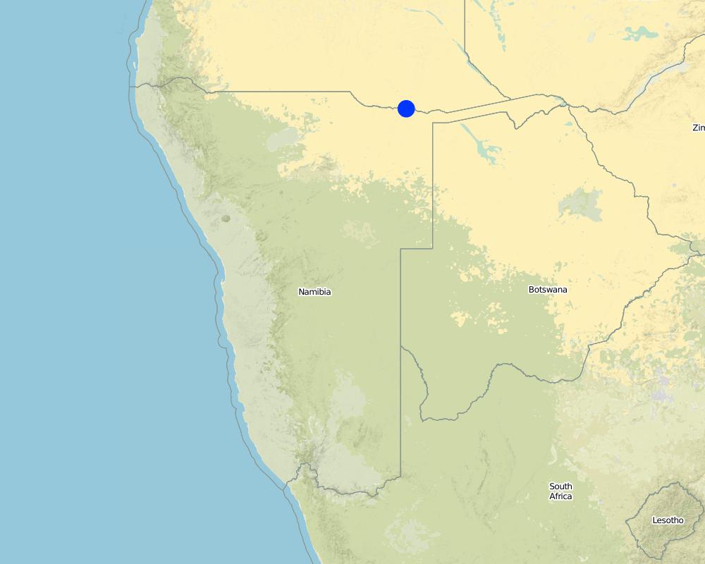
2.5 Country/ region/ locations where the Technology has been applied and which are covered by this assessment
Country:
Namibia
Region/ State/ Province:
Kavango East
Further specification of location:
Mashare
Specify the spread of the Technology:
- evenly spread over an area
If precise area is not known, indicate approximate area covered:
- < 0.1 km2 (10 ha)
Comments:
Boundary points of the Technology area: -17.92 / 20.0 -17.89 / 20.28
SLM technology was applied by trained smallholders on small plots
Map
×2.6 Date of implementation
If precise year is not known, indicate approximate date:
- less than 10 years ago (recently)
2.7 Introduction of the Technology
Specify how the Technology was introduced:
- through projects/ external interventions
Comments (type of project, etc.):
Introduction in the area by Community Economic Development Programme (CEDP) TFO-project in 2011
3. Classification of the SLM Technology
3.1 Main purpose(s) of the Technology
- improve production
- reduce, prevent, restore land degradation
- conserve ecosystem
3.2 Current land use type(s) where the Technology is applied
Land use mixed within the same land unit:
Yes
Specify mixed land use (crops/ grazing/ trees):
- Agro-pastoralism (incl. integrated crop-livestock)

Cropland
- Annual cropping
Number of growing seasons per year:
- 1
Specify:
Longest growing period in days: 135, Longest growing period from month to month: Nov to March

Grazing land
Extensive grazing:
- Semi-nomadic pastoralism
Comments:
Major land use problems (compiler’s opinion): Low and very variable yields per ha; ongoing expansion of fields to less fertile woodlands due to nutrient depletion of originally fertile plots; years with dry spells.
Major land use problems (land users’ perception): Crop wilting and poor yields, opening new areas in search of better fields, cutting down trees, slushing and burning residues
Type of cropping system and major crops comments: Under CA, sunhemp for residue and nitrogen fixing has been grown as green manure and fodder for livestock.
Livestock density: 1-10 LU /km2
3.4 Water supply
Water supply for the land on which the Technology is applied:
- rainfed
3.5 SLM group to which the Technology belongs
- integrated soil fertility management
- cross-slope measure
- water harvesting
3.6 SLM measures comprising the Technology

agronomic measures
- A3: Soil surface treatment

management measures
- M2: Change of management/ intensity level
Comments:
Type of agronomic measures: early planting, mixed cropping / intercropping, mulching, green manure, legume inter-planting, manure / compost / residues, rotations / fallows, minimum tillage, pits
3.7 Main types of land degradation addressed by the Technology

chemical soil deterioration
- Cn: fertility decline and reduced organic matter content (not caused by erosion)

biological degradation
- Bc: reduction of vegetation cover
- Bf: detrimental effects of fires
- Bl: loss of soil life
Comments:
Main causes of degradation: soil management (Missing nutrient returns)
Secondary causes of degradation: over-exploitation of vegetation for domestic use (Grazing and burning of crop residues), population pressure (Expansion of croplands to less fertile soils)
3.8 Prevention, reduction, or restoration of land degradation
Specify the goal of the Technology with regard to land degradation:
- restore/ rehabilitate severely degraded land
4. Technical specifications, implementation activities, inputs, and costs
4.1 Technical drawing of the Technology

Technical specifications (related to technical drawing):
Scheme of CA field with basins
Within the fenced area, basins are dug per hand-hoe in lines with about 15 cm width, 35 cm length and 15 cm depth and in 70 cm distance. To keep the line and position, a rope with knots every 70 cm is used. Each basin is refilled with 2 cans of manure mixed with part of the soil material. Maize or pearl millet - two stages shown on the graph
Location: Mashare. Kavano East/Namibia
Technical knowledge required for field staff / advisors: moderate
Technical knowledge required for land users: low
Main technical functions: increase in nutrient availability (supply, recycling,…)
Secondary technical functions: increase / maintain water stored in soil, increase of biomass (quantity)
Early planting
Remarks: Planting basins prepared in dry season, planting can occur by first rainfalls (earlier than plough-d
Mixed cropping / intercropping
Material/ species: Maize / Millet /Cowpea
Remarks: Cultivated in parallel lines
Mulching
Material/ species: Grasses & crop residues & sunhemp
Remarks: sunhemp cultivated on the CA field and cut to produce mulch
Green manure
Material/ species: branches of fertilizer tree
Manure / compost / residues
Material/ species: Composted manure from cattle post
Rotations / fallows
Material/ species: Maize / Millet /Cowpea
Remarks: Planted in lines and shifted annually
Minimum tillage
Material/ species: Riplines by oxen
Pits
Material/ species: planting basins by hand hoe
Retention/infiltration ditch/pit, sediment/sand trap
Spacing between structures (m): 0.7
Depth of ditches/pits/dams (m): 0.15
Width of ditches/pits/dams (m): 0.15
Length of ditches/pits/dams (m): 0.35
Structural measure: ripline
Spacing between structures (m): 0.7
Depth of ditches/pits/dams (m): 0.25
Width of ditches/pits/dams (m): 0.1
For water harvesting: the ratio between the area where the harvested water is applied and the total area from which water is collected is: 1:8,3
Change of land use practices / intensity level: More specific soil management; crop protection by fencing; earlier seeding
Major change in timing of activities: To a large part, land preparation can be carried out throughout dry season, independent of rainfall level
Author:
Maxon Simfukwe
4.2 General information regarding the calculation of inputs and costs
other/ national currency (specify):
Nam $
If relevant, indicate exchange rate from USD to local currency (e.g. 1 USD = 79.9 Brazilian Real): 1 USD =:
15.5
4.3 Establishment activities
| Activity | Timing (season) | |
|---|---|---|
| 1. | dry season |
4.4 Costs and inputs needed for establishment
| Specify input | Unit | Quantity | Costs per Unit | Total costs per input | % of costs borne by land users | |
|---|---|---|---|---|---|---|
| Labour | labour | ha | 1.0 | 1104.0 | 1104.0 | 100.0 |
| Construction material | Wire for fencing | ha | 1.0 | 224.0 | 224.0 | 100.0 |
| Construction material | sticks & poles | ha | 1.0 | 1114.0 | 1114.0 | 100.0 |
| Total costs for establishment of the Technology | 2442.0 | |||||
| Total costs for establishment of the Technology in USD | 157.55 | |||||
Comments:
Duration of establishment phase: 3 month(s)
4.5 Maintenance/ recurrent activities
| Activity | Timing/ frequency | |
|---|---|---|
| 1. | Repairing fences and de-bushing of the fields | (May - July) |
| 2. | Gatering and spreading of mulch cover | July - Dec |
| 3. | Cutting sunhemp and applying as additional mulch | Feb-Mar |
| 4. | Re-digging the planting basins | August |
| 5. | Manure collection, Planting & fertilizer application | September - December |
| 6. | Sowing of main crops and sunnhemp and fertilizer application | November - December |
| 7. | Intercropping with legumes like groundnuts and cowpeas normally two weeks after germination of cereals. | |
| 8. | Weeding | |
| 9. | Harvesting | April - May |
4.6 Costs and inputs needed for maintenance/ recurrent activities (per year)
| Specify input | Unit | Quantity | Costs per Unit | Total costs per input | % of costs borne by land users | |
|---|---|---|---|---|---|---|
| Labour | labour | ha | 1.0 | 848.0 | 848.0 | 100.0 |
| Plant material | seeds | ha | 1.0 | 22.0 | 22.0 | 100.0 |
| Fertilizers and biocides | fertilizer | ha | 1.0 | 159.0 | 159.0 | 100.0 |
| Fertilizers and biocides | compost/manure | ha | 1.0 | 276.0 | 276.0 | 100.0 |
| Construction material | Wire for fencing | ha | 1.0 | 220.0 | 220.0 | 100.0 |
| Total costs for maintenance of the Technology | 1525.0 | |||||
| Total costs for maintenance of the Technology in USD | 98.39 | |||||
Comments:
Machinery/ tools: Values above are for manual CA using a hoe; an external worker earns 4 N-$ per working hour; above, family labour was multiplied by 4 to estimate the “value” of the family labour invested
The costs are based on labour needs of one year and 500 kg/ha of fertilizer
4.7 Most important factors affecting the costs
Describe the most determinate factors affecting the costs:
CA was designed to require minimal financial investments; theoretically, everything apart from wire for the fences and inorganic fertilizer can be created or gather by the household. This turns CA into a very labour intensive farming practice. The high Dollar values above result from multiplying the (free) family labour invested in farming with the typical hourly wage rate of an external worker
5. Natural and human environment
5.1 Climate
Annual rainfall
- < 250 mm
- 251-500 mm
- 501-750 mm
- 751-1,000 mm
- 1,001-1,500 mm
- 1,501-2,000 mm
- 2,001-3,000 mm
- 3,001-4,000 mm
- > 4,000 mm
Agro-climatic zone
- semi-arid
Thermal climate class: subtropics
5.2 Topography
Slopes on average:
- flat (0-2%)
- gentle (3-5%)
- moderate (6-10%)
- rolling (11-15%)
- hilly (16-30%)
- steep (31-60%)
- very steep (>60%)
Landforms:
- plateau/plains
- ridges
- mountain slopes
- hill slopes
- footslopes
- valley floors
Altitudinal zone:
- 0-100 m a.s.l.
- 101-500 m a.s.l.
- 501-1,000 m a.s.l.
- 1,001-1,500 m a.s.l.
- 1,501-2,000 m a.s.l.
- 2,001-2,500 m a.s.l.
- 2,501-3,000 m a.s.l.
- 3,001-4,000 m a.s.l.
- > 4,000 m a.s.l.
5.3 Soils
Soil depth on average:
- very shallow (0-20 cm)
- shallow (21-50 cm)
- moderately deep (51-80 cm)
- deep (81-120 cm)
- very deep (> 120 cm)
Soil texture (topsoil):
- coarse/ light (sandy)
- medium (loamy, silty)
Topsoil organic matter:
- medium (1-3%)
- low (<1%)
5.4 Water availability and quality
Ground water table:
5-50 m
Availability of surface water:
poor/ none
Water quality (untreated):
good drinking water
5.5 Biodiversity
Species diversity:
- medium
5.6 Characteristics of land users applying the Technology
Market orientation of production system:
- subsistence (self-supply)
Off-farm income:
- 10-50% of all income
Relative level of wealth:
- poor
- average
Individuals or groups:
- individual/ household
Level of mechanization:
- manual work
- animal traction
Gender:
- women
- men
Indicate other relevant characteristics of the land users:
Land users applying the Technology are mainly common / average land users
Population density: 10-50 persons/km2
Annual population growth: 1% - 2% (One farmer to our knowledge could be considered wealthy). (Few average farmers). (Mostly CA farmers are poor).
5.7 Average area of land used by land users applying the Technology
- < 0.5 ha
- 0.5-1 ha
- 1-2 ha
- 2-5 ha
- 5-15 ha
- 15-50 ha
- 50-100 ha
- 100-500 ha
- 500-1,000 ha
- 1,000-10,000 ha
- > 10,000 ha
Is this considered small-, medium- or large-scale (referring to local context)?
- small-scale
5.8 Land ownership, land use rights, and water use rights
Land ownership:
- state
- communal/ village
Land use rights:
- communal (organized)
Water use rights:
- communal (organized)
Comments:
parallel existence of state and communal laws
5.9 Access to services and infrastructure
health:
- poor
- moderate
- good
education:
- poor
- moderate
- good
technical assistance:
- poor
- moderate
- good
employment (e.g. off-farm):
- poor
- moderate
- good
markets:
- poor
- moderate
- good
energy:
- poor
- moderate
- good
roads and transport:
- poor
- moderate
- good
drinking water and sanitation:
- poor
- moderate
- good
financial services:
- poor
- moderate
- good
6. Impacts and concluding statements
6.1 On-site impacts the Technology has shown
Socio-economic impacts
Production
crop production
Income and costs
expenses on agricultural inputs
Comments/ specify:
not measured but assumed
farm income
workload
Comments/ specify:
not measured but assumed
Socio-cultural impacts
food security/ self-sufficiency
health situation
cultural opportunities
recreational opportunities
conflict mitigation
Comments/ specify:
Envy and gossip were observed
situation of socially and economically disadvantaged groups
contribution to human well-being
Comments/ specify:
Improved and stabilized yields help rural families to adapt to modern lifestyles. However, the long-term contribution of CA to the well-being of the local farmers cannot be foreseen. The establishment of family-owned fenced areas for crop production is likely to have an influence on the social structure of the rural communities.
Ecological impacts
Water cycle/ runoff
evaporation
Comments/ specify:
not measured but assumed
Soil
soil moisture
Comments/ specify:
not measured but assumed
soil cover
Comments/ specify:
not measured but assumed
nutrient cycling/ recharge
Comments/ specify:
not measured but assumed
soil organic matter/ below ground C
Comments/ specify:
not measured but assumed
6.3 Exposure and sensitivity of the Technology to gradual climate change and climate-related extremes/ disasters (as perceived by land users)
Climate-related extremes (disasters)
Climatological disasters
| How does the Technology cope with it? | |
|---|---|
| drought | well |
Comments:
Dig basins at 20cm (0.20m) deep; and extra water harvesting basins at 0.45m in-between the rows. For the ox-ripped lines, use ripper wings to open a wider farrow for water harvesting
6.4 Cost-benefit analysis
How do the benefits compare with the establishment costs (from land users’ perspective)?
Short-term returns:
slightly negative
Long-term returns:
positive
How do the benefits compare with the maintenance/ recurrent costs (from land users' perspective)?
Short-term returns:
neutral/ balanced
Long-term returns:
positive
6.5 Adoption of the Technology
Comments:
SLM Technology has been applied by own interest of smallholders
100% of land user families have adopted the Technology without any external material support
There is a strong trend towards spontaneous adoption of the Technology
6.7 Strengths/ advantages/ opportunities of the Technology
| Strengths/ advantages/ opportunities in the land user’s view |
|---|
| Saves labour over time |
| Can use less land compared to conventional system for the same harvest/yield |
| Strengths/ advantages/ opportunities in the compiler’s or other key resource person’s view |
|---|
| A strength of the system is the timely land preparation |
| The advantage of permanent planting stations results from the higher availability of nutrients to crop roots. |
| The moisture retention within the rooting space is improved by the surface structure and the increase in soil organic matter |
| The rotations of crop rotations is encouraged |
| All inputs can be used precicely, there is less wastage of inputs |
6.8 Weaknesses/ disadvantages/ risks of the Technology and ways of overcoming them
| Weaknesses/ disadvantages/ risks in the land user’s view | How can they be overcome? |
|---|---|
| The weed management is labour intensive and the impact of pests might be a future challange. | The application of more mulch and the weeding regularly in the first part of the season is supposed to reduce weeds. |
| Weaknesses/ disadvantages/ risks in the compiler’s or other key resource person’s view | How can they be overcome? |
|---|---|
| To start with this technology is labour intensive at the beginning. In this moment, the hard pan caused by years of ploughing has to be loosened. | Because the basins/riplines are permanently maintained in CA, the preceding land preparations become easier. Also since land preparation starts before on-set of rains, one can spread labour by starting just after harvesting crop |
| There is a general problem of constructing fences around fields in communal lands, as state authorities declare this land as being owned by the state. | By agreeing with the local leadership to allow those doing CA to fence off their fields for proper keeping of residues and basins/riplines that might be prone to free livestock grazing after crop harvests. |
7. References and links
7.1 Methods/ sources of information
- field visits, field surveys
- interviews with land users
When were the data compiled (in the field)?
01/03/2001
7.2 References to available publications
Title, author, year, ISBN:
Groengroeft, A., et al. (2013) A method for yield assessment on rainfeld dryland agricultural fields.
Available from where? Costs?
Biodiversity & Ecology 5:279 - 286
Title, author, year, ISBN:
Kowalski, B. et al. (2013) Mashare - The People.
Available from where? Costs?
Biodiversity & Ecology 5:121-128
Title, author, year, ISBN:
Pröpper, M. et al. (2010) Causes and perspectives of land-cover change through expanding cultivation in Kavango.
Available from where? Costs?
Biodiversity in southern Africa. Volume 3: Implications for landuse and management, eds. M. T. Hoffman, U. Schmiedel and N. Jürgens. Göttingen & Windhoek: Klaus Hess Publishers.
Title, author, year, ISBN:
Pröpper, M. et al. (2015) The Future Okavango – Findings, Scenarios and Recommendations for Action.
Available from where? Costs?
Research Project Final Synthesis Report 2010-2015, 190. Windhoek: University of Hamburg
Links and modules
Expand all Collapse allLinks
No links
Modules
No modules