Casuaria - Tree belt for sand dune fixation [Senegal]
- Creation:
- Update:
- Compiler: Julie Zähringer
- Editor: –
- Reviewers: Fabian Ottiger, Alexandra Gavilano
Bande de Filao
technologies_1357 - Senegal
View sections
Expand all Collapse all1. General information
1.2 Contact details of resource persons and institutions involved in the assessment and documentation of the Technology
SLM specialist:
SLM specialist:
Waly Paul
Eaux et Forêts
Senegal
Name of project which facilitated the documentation/ evaluation of the Technology (if relevant)
Recueil d'expériences de gestion durable des terres au Sénégal (GEF-FAO / LADA)Name of project which facilitated the documentation/ evaluation of the Technology (if relevant)
Book project: SLM in Practice - Guidelines and Best Practices for Sub-Saharan Africa (SLM in Practice) {'additional_translations': {}, 'value': 455, 'label': 'Name of the institution(s) which facilitated the documentation/ evaluation of the Technology (if relevant)', 'text': 'CSE (CSE) - Senegal', 'template': 'raw'} {'additional_translations': {}, 'value': 455, 'label': 'Name of the institution(s) which facilitated the documentation/ evaluation of the Technology (if relevant)', 'text': 'CSE (CSE) - Senegal', 'template': 'raw'}1.3 Conditions regarding the use of data documented through WOCAT
The compiler and key resource person(s) accept the conditions regarding the use of data documented through WOCAT:
Yes
2. Description of the SLM Technology
2.1 Short description of the Technology
Definition of the Technology:
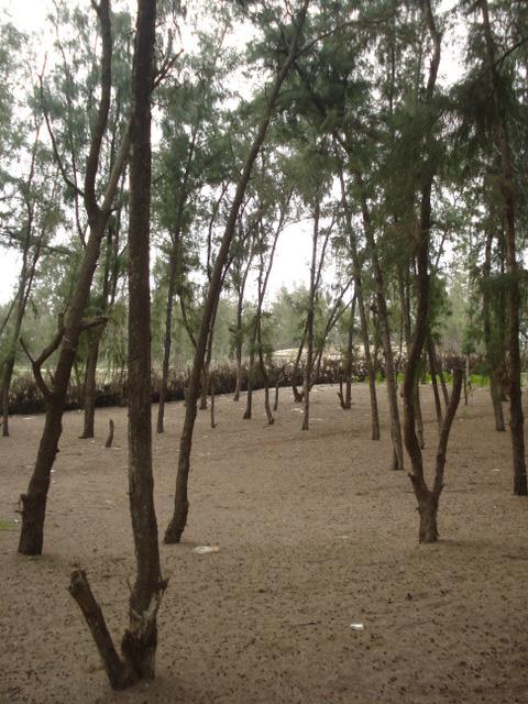
The bande de filao, a 200 m wide belt of Casuarina equisetifolia trees, was established along the Senegalese coast from Dakar to St.Louis, to protect the adjacent Niayes region from wandering sand dunes.
2.2 Detailed description of the Technology
Description:
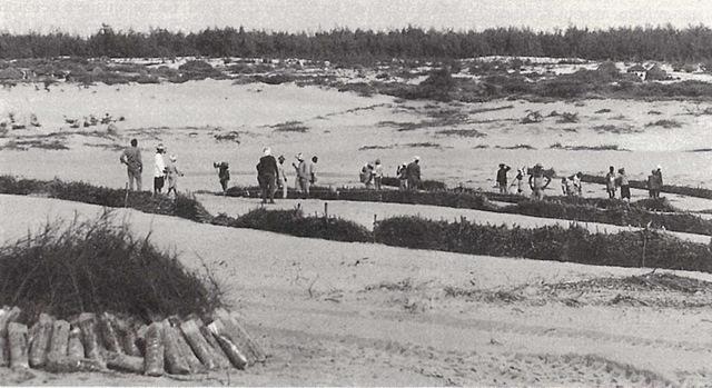
The Niayes, a territory of 5-30 km width covering a surface of 4,200 km2, is known for its favourable conditions for vegetable production. However, droughts, deforestation and overgrazing have caused gradual desertification and loss of stabilising vegetation cover on sand dunes. The dunes began to advance at a rate of up to 10-12 m per year and threatened villages and production areas.
The establishment of the tree belt started in the 1970s and continued until the late 1990s. The exotic nitrogen-fixing Casuarina equisetifolia was found to perfectly fit into the harsh ecological environment with its poor sandy soils, strong winds, shifting sand and proximity to the sea. Seedlings were raised in nurseries, then planted on a 2.5 x 2.5 m grid – protected by palisades and irrigated at the initial stage. The filao belt covers an area of about 9,700 ha and effectively halts wind erosion and movement of sand dunes, resulting in multiple positive impacts on the environment and the 120,000 people living in the area: it provides protection of villages, allowing vegetable production in inter-dunal depressions, and last but not least - builds up resources of wood. Without the tree belt, life in the Niayes would not be possible. Furthermore, wind speed was reduced also on the sea side, making inshore fishery possible during the whole year (before it was limited to 3 months).
The big challenge is to gradually replace the stands of Casuarina trees that have reached senescence (after approx. 30 years). A management plan has been developed to assure the continuity of this important protective system.
2.3 Photos of the Technology
Media Gallery
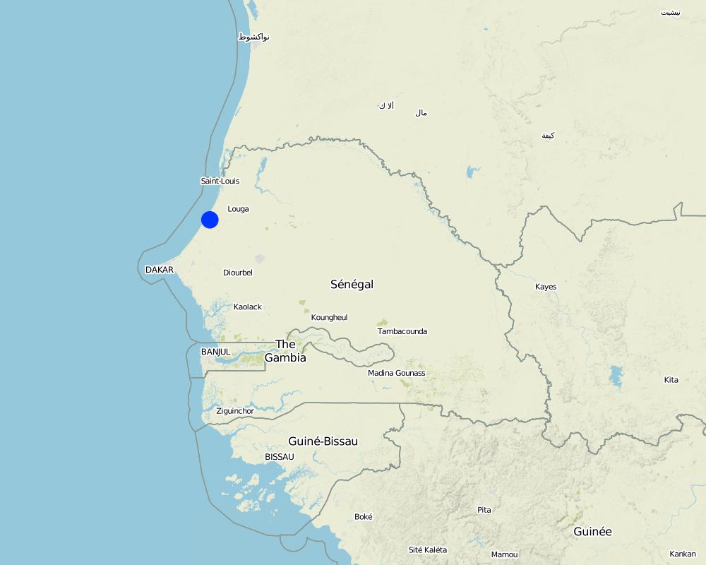
2.5 Country/ region/ locations where the Technology has been applied and which are covered by this assessment
Country:
Senegal
Region/ State/ Province:
Departement de Kébémer
Further specification of location:
Lompoul
Comments:
Total area covered by the SLM Technology is 97 km2.
Map
×2.6 Date of implementation
If precise year is not known, indicate approximate date:
- 10-50 years ago
2.7 Introduction of the Technology
Specify how the Technology was introduced:
- through projects/ external interventions
Comments (type of project, etc.):
en 1925 les colons français ont commencé à expérimenter avec Casuarina equisetifolia mais les premiers plantations qui avaient du succès ont été établiés en 1948
3. Classification of the SLM Technology
3.1 Main purpose(s) of the Technology
- improve production
- reduce, prevent, restore land degradation
- reduce risk of disasters
- adapt to climate change/ extremes and its impacts
3.2 Current land use type(s) where the Technology is applied

Forest/ woodlands
- Tree plantation, afforestation
Type of tree:
- Casuarina equisetifolia
Products and services:
- Fuelwood
- Recreation/ tourism
- Protection against natural hazards

Other
Specify:
Dunes
Comments:
Major land use problems (compiler’s opinion): Biological degradation: reduction of vegetation cover; Erosion by wind: loss of topsoil: uniform displacement, off-site degradation
Plantation forestry: senescence of settlement
Future (final) land use (after implementation of SLM Technology): Forests / woodlands: Fp: Plantations, afforestations
Number of growing seasons per year: 1
Longest growing period in days: 90 Longest growing period from month to month: July-September
3.3 Has land use changed due to the implementation of the Technology?
Has land use changed due to the implementation of the Technology?
- Yes (Please fill out the questions below with regard to the land use before implementation of the Technology)

Unproductive land
Specify:
wastelands, deserts, glaciers, swamps, recreation areas, etc
3.5 SLM group to which the Technology belongs
- windbreak/ shelterbelt
3.6 SLM measures comprising the Technology

vegetative measures
- V1: Tree and shrub cover

structural measures
- S6: Walls, barriers, palisades, fences
Comments:
Main measures: vegetative measures
Secondary measures: structural measures
3.7 Main types of land degradation addressed by the Technology

soil erosion by wind
- Et: loss of topsoil
- Eo: offsite degradation effects

chemical soil deterioration
- Cn: fertility decline and reduced organic matter content (not caused by erosion)

biological degradation
- Bc: reduction of vegetation cover
Comments:
Main type of degradation addressed: Et: loss of topsoil, Eo: offsite degradation effects, Bc: reduction of vegetation cover
Secondary types of degradation addressed: Cn: fertility decline and reduced organic matter content
Main causes of degradation: deforestation / removal of natural vegetation (incl. forest fires), droughts (droughts between 1950 and 1970 have affected the vegetation cover of the dunes), population pressure (people have made the dunes accessible for cultivation land)
3.8 Prevention, reduction, or restoration of land degradation
Specify the goal of the Technology with regard to land degradation:
- prevent land degradation
- restore/ rehabilitate severely degraded land
4. Technical specifications, implementation activities, inputs, and costs
4.1 Technical drawing of the Technology
Technical specifications (related to technical drawing):
Technical knowledge required for field staff / advisors: high
Technical knowledge required for land users: high
Main technical functions: improvement of ground cover, stabilisation of soil (eg by tree roots against land slides), reduction in wind speed
Secondary technical functions: increase in organic matter, increase of biomass (quantity)
Aligned: -against wind
Vegetative material: T : trees / shrubs
Number of plants per (ha): 1600
Vertical interval within rows / strips / blocks (m): 2
Width within rows / strips / blocks (m): 3
Trees/ shrubs species: Casuarina equisetifolia (planted)
4.2 General information regarding the calculation of inputs and costs
other/ national currency (specify):
FCFA
If relevant, indicate exchange rate from USD to local currency (e.g. 1 USD = 79.9 Brazilian Real): 1 USD =:
455.0
Indicate average wage cost of hired labour per day:
3.00
4.3 Establishment activities
| Activity | Timing (season) | |
|---|---|---|
| 1. | Initial protection with palisades (1 m high; 70 m from the coast; 1 year before planting) | 1 year before plantation |
| 2. | Enclosure: wire Establish 0.5 m high palisades with a spacing of 10 - 20 m (depending on the slope of the dunes), perpendicular to the direction of the wind; In Guiera senegalensis on pickets of Euphorbia balsamiferafence protects young plants from roaming animals | avant la plantation, nov.-juin |
| 3. | Establish 0.5 m high palisades with a spacing of 10 - 20 m (depending on the slope of the dunes), perpendicular to the direction of the wind; In Guiera senegalEnclosure: wire fence protects young plants from roaming animalsensis on pickets of Euphorbia balsamifera | avant la plantation, nov.-juin |
| 4. | Production of seedlings in nurseries / Seedling plantings on a 2.5 x 2.5 m grid (1600 plants / ha) | janvier-février |
| 5. | Custody of the planting site (protection of seedlings) |
4.4 Costs and inputs needed for establishment
| Specify input | Unit | Quantity | Costs per Unit | Total costs per input | % of costs borne by land users | |
|---|---|---|---|---|---|---|
| Labour | Labour | ha | 1.0 | 88.0 | 88.0 | |
| Plant material | Seedlings | ha | 1.0 | 450.0 | 450.0 | |
| Construction material | Wire fence | ha | 1.0 | 385.0 | 385.0 | |
| Other | Transport costs | ha | 1.0 | 880.0 | 880.0 | |
| Total costs for establishment of the Technology | 1803.0 | |||||
| Total costs for establishment of the Technology in USD | 3.96 | |||||
4.5 Maintenance/ recurrent activities
| Activity | Timing/ frequency | |
|---|---|---|
| 1. | Watering filaos during first year. | |
| 2. | Monitor planting | |
| 3. | After 25-30 years, replace the whole stand with new plants |
4.6 Costs and inputs needed for maintenance/ recurrent activities (per year)
| Specify input | Unit | Quantity | Costs per Unit | Total costs per input | % of costs borne by land users | |
|---|---|---|---|---|---|---|
| Other | Transport costs | ha | 1.0 | 880.0 | 880.0 | |
| Total costs for maintenance of the Technology | 880.0 | |||||
| Total costs for maintenance of the Technology in USD | 1.93 | |||||
Comments:
The costs are calculated for 2 ha of dune fixation; the costs of labour are indicated per month.
4.7 Most important factors affecting the costs
Describe the most determinate factors affecting the costs:
Costs for establishment are high. All inputs were fully subsidised. Implementing agency was governmental ‘Service des Eaux et
Forêts’ with funding from ACDI and USAID. Reestablishment starts after 25-30 years when trees reach senescence.
5. Natural and human environment
5.1 Climate
Annual rainfall
- < 250 mm
- 251-500 mm
- 501-750 mm
- 751-1,000 mm
- 1,001-1,500 mm
- 1,501-2,000 mm
- 2,001-3,000 mm
- 3,001-4,000 mm
- > 4,000 mm
Specify average annual rainfall (if known), in mm:
300.00
Specifications/ comments on rainfall:
9 months of dry season
Agro-climatic zone
- semi-arid
Thermal climate class: tropics, Sahel zone
5.2 Topography
Slopes on average:
- flat (0-2%)
- gentle (3-5%)
- moderate (6-10%)
- rolling (11-15%)
- hilly (16-30%)
- steep (31-60%)
- very steep (>60%)
Landforms:
- plateau/plains
- ridges
- mountain slopes
- hill slopes
- footslopes
- valley floors
Altitudinal zone:
- 0-100 m a.s.l.
- 101-500 m a.s.l.
- 501-1,000 m a.s.l.
- 1,001-1,500 m a.s.l.
- 1,501-2,000 m a.s.l.
- 2,001-2,500 m a.s.l.
- 2,501-3,000 m a.s.l.
- 3,001-4,000 m a.s.l.
- > 4,000 m a.s.l.
5.3 Soils
Soil depth on average:
- very shallow (0-20 cm)
- shallow (21-50 cm)
- moderately deep (51-80 cm)
- deep (81-120 cm)
- very deep (> 120 cm)
Soil texture (topsoil):
- coarse/ light (sandy)
Topsoil organic matter:
- low (<1%)
If available, attach full soil description or specify the available information, e.g. soil type, soil PH/ acidity, Cation Exchange Capacity, nitrogen, salinity etc.
Soil fertility: Low
Soil drainage/infiltration: Good
Soil water storage capacity: Very low
5.4 Water availability and quality
Ground water table:
5-50 m
Availability of surface water:
medium
Water quality (untreated):
good drinking water
Comments and further specifications on water quality and quantity:
Ground water table: 5-50m (20 m during rain season, 30 m during dry season)
Water quality (untreated): Good drinking water (dry season, ranked 1) and for agricultural use only (irrigation) as well as unusable (ranked 2, rain season)
Availability of surface water: Also poor/ none
5.5 Biodiversity
Species diversity:
- medium
5.6 Characteristics of land users applying the Technology
Market orientation of production system:
- subsistence (self-supply)
Individuals or groups:
- groups/ community
Indicate other relevant characteristics of the land users:
Population density: 50-100 persons/km2
Annual population growth: 2% - 3%
Market orientation: Subsistence (only collection of litter and dead wood permitted)
5.8 Land ownership, land use rights, and water use rights
Land ownership:
- state
- individual, not titled
Land use rights:
- communal (organized)
Water use rights:
- communal (organized)
5.9 Access to services and infrastructure
health:
- poor
- moderate
- good
education:
- poor
- moderate
- good
technical assistance:
- poor
- moderate
- good
employment (e.g. off-farm):
- poor
- moderate
- good
markets:
- poor
- moderate
- good
energy:
- poor
- moderate
- good
roads and transport:
- poor
- moderate
- good
drinking water and sanitation:
- poor
- moderate
- good
financial services:
- poor
- moderate
- good
6. Impacts and concluding statements
6.1 On-site impacts the Technology has shown
Socio-economic impacts
Production
wood production
Comments/ specify:
Casuarina equisetifolia trees reach senescence after 30-50 years and do not regenerate naturally ➜ plantation activities need to be taken up again
Water availability and quality
demand for irrigation water
Comments/ specify:
Sprouts need irrigation water
Other socio-economic impacts
Production of litter
Comments/ specify:
Used as mulch and for composting by vegetable farmers or by fishermen to smoke fish
Socio-cultural impacts
recreational opportunities
community institutions
Improve livelihoods and human well-being
Comments/ specify:
Land users emphasise that without the technology they would not be able to live in this area.
Ecological impacts
Soil
soil cover
Comments/ specify:
With litter
soil loss
soil organic matter/ below ground C
Comments/ specify:
Litter
Biodiversity: vegetation, animals
biomass/ above ground C
Climate and disaster risk reduction
flood impacts
drought impacts
emission of carbon and greenhouse gases
wind velocity
6.2 Off-site impacts the Technology has shown
wind transported sediments
damage on neighbours' fields
damage on public/ private infrastructure
Making fishery possible all year round
Comments/ specify:
Therefore creating an additional income source
Making horticulture possible in the region
6.4 Cost-benefit analysis
How do the benefits compare with the establishment costs (from land users’ perspective)?
Short-term returns:
slightly positive
Long-term returns:
very positive
How do the benefits compare with the maintenance/ recurrent costs (from land users' perspective)?
Short-term returns:
slightly positive
Long-term returns:
very positive
Comments:
The technology focuses on off-site benefits!
6.5 Adoption of the Technology
- > 50%
Of all those who have adopted the Technology, how many did so spontaneously, i.e. without receiving any material incentives/ payments?
- 0-10%
Comments:
100% of land user families have adopted the Technology with external material support
6.7 Strengths/ advantages/ opportunities of the Technology
| Strengths/ advantages/ opportunities in the compiler’s or other key resource person’s view |
|---|
|
Stabilisationof dunes - protection of villages permission of horticulture in interdunal depressions How can they be sustained / enhanced? promote regeneration of trees |
|
Reduction of wind velocity and therefore mitigation of aerolien erosion How can they be sustained / enhanced? promote regeneration of trees |
|
Increased production of litter used as mulch and for composting by vegetable farmers or by fishermen to smoke fish How can they be sustained / enhanced? encourage techniqules compost techniques |
| Production of firewood |
6.8 Weaknesses/ disadvantages/ risks of the Technology and ways of overcoming them
| Weaknesses/ disadvantages/ risks in the land user’s view | How can they be overcome? |
|---|---|
| Making all year round fishery possible and therefore loosing labour force for vegetable cultivation |
| Weaknesses/ disadvantages/ risks in the compiler’s or other key resource person’s view | How can they be overcome? |
|---|---|
| High establishment costs for large scale plantations | plantation activities need to be taken up again; In the hinterland reforestation with local Cocos should be tried. |
| Casuarina equisetifolia trees reach senescence after 30-50 years and do not regenerate naturally | |
| Increased demand for irrigation water | |
| Increased amount of plastic waste (due to attraction of tourists). |
7. References and links
7.1 Methods/ sources of information
7.2 References to available publications
Title, author, year, ISBN:
Mailly, D., Ndiaye, P., Margolis, H. A., & Pineau, M. (1994). Fixation des dunes et reboisement avec le filao (Casuarina equisetifolia) dans la zone du littoral nord du Sénégal.
Available from where? Costs?
The Forestry Chronicle, 70(3)
Title, author, year, ISBN:
Maheut, J., & Dommergues, Y. (1959). La Fixation par le Reboisement des Dunes de la Presqu'Ile du Cap-Vert et l'Evolution Biologique des Sols.
Available from where? Costs?
Bois et Forêts des Tropiques, (63).
Links and modules
Expand all Collapse allLinks
No links
Modules
No modules