
Traditional stone wall terraces [South Africa]
- Creation:
- Update:
- Compiler: William Critchley
- Editor: –
- Reviewers: David Streiff, Deborah Niggli, Alexandra Gavilano
Mitsheto (Venda language)
technologies_1369 - South Africa
View sections
Expand all Collapse all1. General information
1.2 Contact details of resource persons and institutions involved in the assessment and documentation of the Technology
Name of project which facilitated the documentation/ evaluation of the Technology (if relevant)
Book project: where the land is greener - Case Studies and Analysis of Soil and Water Conservation Initiatives Worldwide (where the land is greener)Name of the institution(s) which facilitated the documentation/ evaluation of the Technology (if relevant)
CIS-Centre for International Cooperation (CIS-Centre for International Cooperation) - Netherlands1.3 Conditions regarding the use of data documented through WOCAT
The compiler and key resource person(s) accept the conditions regarding the use of data documented through WOCAT:
Yes
1.5 Reference to Questionnaire(s) on SLM Approaches (documented using WOCAT)
Community tradition [South Africa]
Inherited, and still practiced, tradition of stone terracing - passed down from generation to generation.
- Compiler: William Critchley
2. Description of the SLM Technology
2.1 Short description of the Technology
Definition of the Technology:
Stone walls built on sloping fields to create terraces for cultivation and conservation: both ancient and contemporary.
2.2 Detailed description of the Technology
Description:
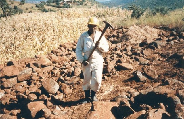
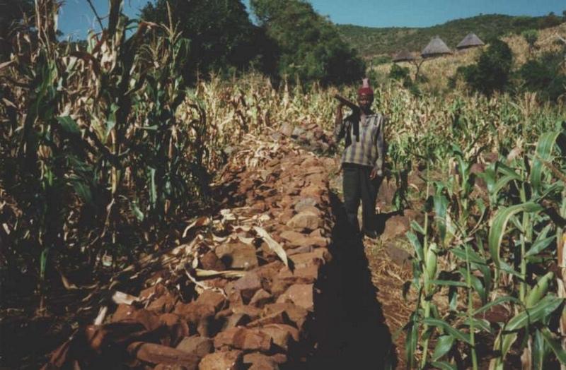
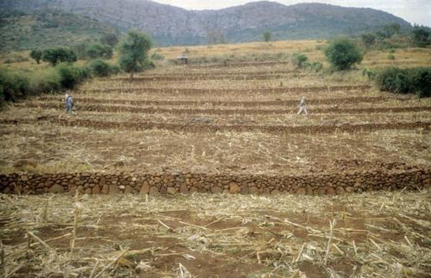
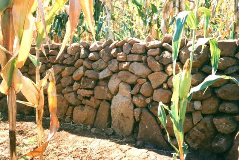
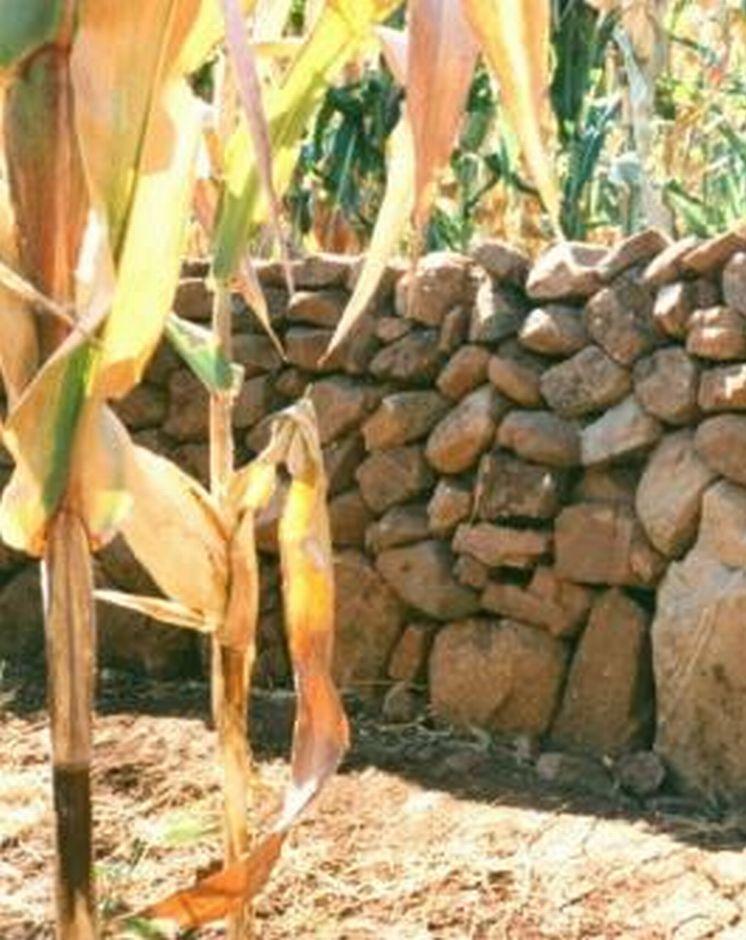
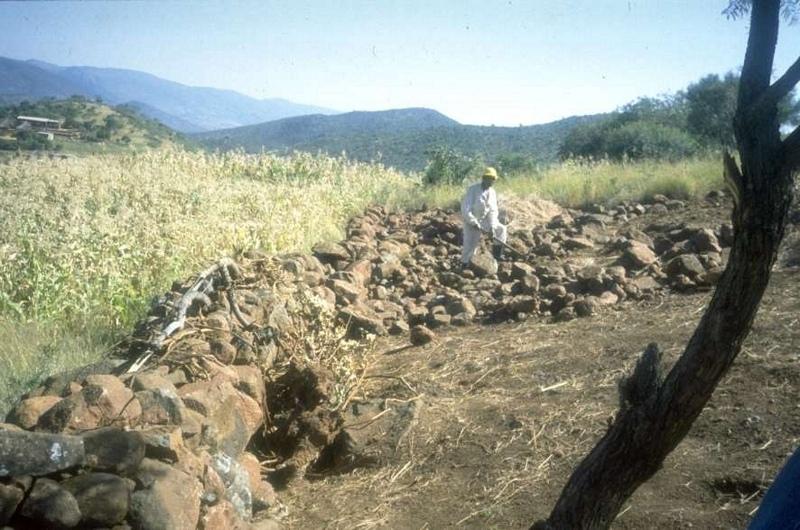
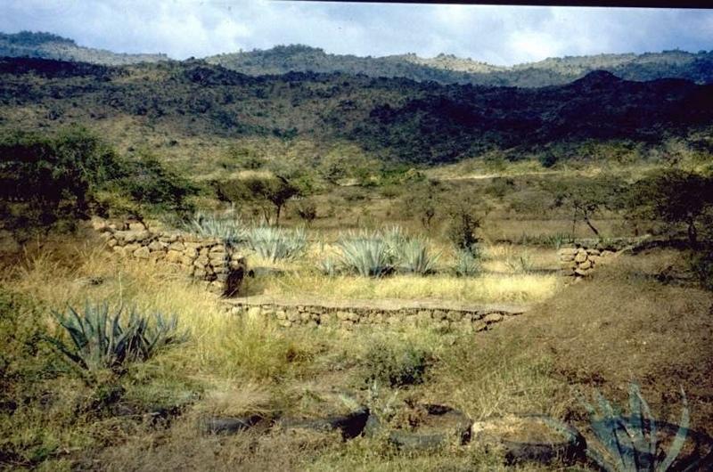
In this hilly, mixed farming area, stone terrace walls are a tradition. They are built across the slope when new land is cleared of loose stone and brought into crop cultivation. The dimensions of the terrace walls and the spacing between them depend on various factors, especially the slope and the amount of stone in the field. The walls may be up to 1.25 m high, from 1.0 to 1.5 m in base width, and between 20 and 50 m long. Spacing is from 3 to 10 m apart. Design of stone terrace walls varies. Some walls are very neatly built, others are merely piles of stone across the slope: this depends on the individual land user. The walls are built up each year with further stones: this may just be as more loose stone comes to the surface when ploughing, or also by digging out larger stones to deliberately build up the height of the walls as it silts up behind. Such terracing is generally confined to slopes between 20% and 50%. From 12% to 20% contour grass strips (thambaladza) are normally used, but below 12% land is rarely protected with structures or strips.
Purpose of the Technology: The purpose of terracing, apart from simultaneously clearing the land of stone, is to guard against loss of topsoil. Together with contour ploughing this helps to keep soil fertility in place on sloping cropland in a subhumid area. Rainfall is around 1,000 mm per annum and maize is the most common crop, but various other annuals (beans, pumpkins, sorghum etc) and perennials (peaches, avocadoes, oranges etc) are also grown.
Natural / human environment: This example of land conservation is probably unique in a former South African ‘homeland’. In such areas, where the black population were concentrated at high population densities under the former apartheid regime, land degradation rather than soil conservation was the rule. These terraces continue to be built to this day as new land is opened up, despite the high amounts of labour (300-500 person days per hectare) involved in establishment. A study of the conservation systems used in the area and local attitudes to them, showed that the benefits of conservation were well understood by local farmers (see reference). Those questioned identified retention of soil - and of soil fertility in particular - as being of paramount importance. No mention was made of terraces being built simply to remove surface stone. The only downside mentioned (by a few) was the loss of cultivable land area. The key to the persistence of the terraces in this area is, therefore, that the land users understand and appreciate the place of terraces in maintaining soil fertility, and their considerable contribution to crop production.
2.3 Photos of the Technology
Media Gallery
2.5 Country/ region/ locations where the Technology has been applied and which are covered by this assessment
Country:
South Africa
Region/ State/ Province:
Limpopo Province
Further specification of location:
Thononda Ward (Thohoyandou district)
Specify the spread of the Technology:
- evenly spread over an area
If the Technology is evenly spread over an area, specify area covered (in km2):
8.0
If precise area is not known, indicate approximate area covered:
- 1-10 km2
Comments:
Total area covered by the SLM Technology is 8 km2.
Within the Northern region of South Africa's Northern Province (formerly "Venda") a few areas are apparently covered with ancient stone terraces - but Thononda Ward of Thohoyandou district is the best example and the only one
Map
×2.6 Date of implementation
If precise year is not known, indicate approximate date:
- more than 50 years ago (traditional)
2.7 Introduction of the Technology
Specify how the Technology was introduced:
- as part of a traditional system (> 50 years)
Comments (type of project, etc.):
May have originated with the Shona of Zimbabwe and the tradition brought with them when some moved south to Venda
3. Classification of the SLM Technology
3.1 Main purpose(s) of the Technology
- reduce, prevent, restore land degradation
3.2 Current land use type(s) where the Technology is applied

Cropland
- Annual cropping
- Tree and shrub cropping
Annual cropping - Specify crops:
- cereals - maize
Tree and shrub cropping - Specify crops:
- avocado
Number of growing seasons per year:
- 1
Specify:
Longest growing period in days: 150; Longest growing period from month to month: Nov - May
Comments:
Major cash crop: Maize and avocado
Major food crop: Maize
Major land use problems (compiler’s opinion): Agreement with the land-user
Major land use problems (land users’ perception): Decline in fertility of soil, erosion on roads/from roads, yield burning leading to runoff.
3.4 Water supply
Water supply for the land on which the Technology is applied:
- rainfed
3.5 SLM group to which the Technology belongs
- cross-slope measure
3.6 SLM measures comprising the Technology

agronomic measures

structural measures
- S1: Terraces
Comments:
Main measures: structural measures
Secondary measures: agronomic measures
3.7 Main types of land degradation addressed by the Technology

soil erosion by water
- Wt: loss of topsoil/ surface erosion

chemical soil deterioration
- Cn: fertility decline and reduced organic matter content (not caused by erosion)
Comments:
Main causes of degradation: Heavy / extreme rainfall (intensity/amounts) (slope), other natural causes (avalanches, volcanic eruptions, mud flows, highly susceptible natural resources, extreme topography, etc.) specify (Slope/rainfall)
Secondary causes of degradation: other human induced causes (specify) (Burning of veld/grazing land upslope)
3.8 Prevention, reduction, or restoration of land degradation
Specify the goal of the Technology with regard to land degradation:
- prevent land degradation
4. Technical specifications, implementation activities, inputs, and costs
4.1 Technical drawing of the Technology
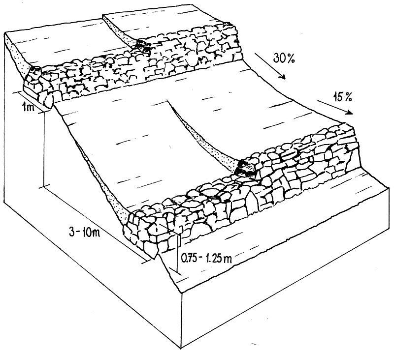
Technical specifications (related to technical drawing):
Layout of stone wall terraces: the walls are built up over time (right) as soil accumulates behind the barriers.
Date: Northern Province
Technical knowledge required for land users: moderate
Main technical functions: control of dispersed runoff: impede / retard
Secondary technical functions: reduction of slope angle, reduction of slope length
Structural measure: Bunds/banks: contour
Vertical interval between structures (m): varied
Spacing between structures (m): 3 -10
Height of bunds/banks/others (m): > 0.75
Width of bunds/banks/others (m): > 1.5
Length of bunds/banks/others (m): 20 -50
Construction material (stone): From within fields only
Slope (which determines the spacing indicated above): 30%
If the original slope has changed as a result of the Technology, the slope today is: 15%
Author:
Will Critchley, Amsterdam, The Netherlands
4.2 General information regarding the calculation of inputs and costs
Specify how costs and inputs were calculated:
- per Technology unit
Specify unit:
ha
Specify currency used for cost calculations:
- USD
Indicate average wage cost of hired labour per day:
3.50
4.3 Establishment activities
| Activity | Timing (season) | |
|---|---|---|
| 1. | Initial construction of terrace walls (Layout is by eye: no instruments used) | Dry season |
| 2. | Construction of new stone walls begins with a shallow trench into which large foundation stones are laid (or rolled downhill with a ‘crowbar’ – a long steel lever - if very big). | |
| 3. | Terrace walls are then built up with successively smaller stones: design depends on the individual. | |
| 4. | Stiles (low points) are generally left in the walls to allow human passage, but these are ‘staggered’ (ie not all in a straight line up-and-down slope) to avoid gullies forming. |
4.4 Costs and inputs needed for establishment
| Specify input | Unit | Quantity | Costs per Unit | Total costs per input | % of costs borne by land users | |
|---|---|---|---|---|---|---|
| Labour | Construction of stone walls and terraces | persons/day/ha | 357.0 | 3.5 | 1249.5 | 100.0 |
| Equipment | Tools | ha | 1.0 | 20.0 | 20.0 | 100.0 |
| Total costs for establishment of the Technology | 1269.5 | |||||
| Total costs for establishment of the Technology in USD | 1269.5 | |||||
Comments:
Duration of establishment phase: 12 month(s)
4.5 Maintenance/ recurrent activities
| Activity | Timing/ frequency | |
|---|---|---|
| 1. | The walls are increased in height each year as it silts up behind. | Dry season (winter)/Annual |
4.6 Costs and inputs needed for maintenance/ recurrent activities (per year)
| Specify input | Unit | Quantity | Costs per Unit | Total costs per input | % of costs borne by land users | |
|---|---|---|---|---|---|---|
| Labour | Increase hight | persons/day/ha | 46.0 | 3.5 | 161.0 | 100.0 |
| Total costs for maintenance of the Technology | 161.0 | |||||
| Total costs for maintenance of the Technology in USD | 161.0 | |||||
Comments:
A 100 m x 100 m field with a slope of about 20 degrees (35%) with bund of 0,75 sqm cross section initially at 10 m horizontal intervals assuming 2 sqm moved per- person-day
4.7 Most important factors affecting the costs
Describe the most determinate factors affecting the costs:
Slope and amount of loose stones available (the more loose stones the more has to been moved to make cultivation possible)
5. Natural and human environment
5.1 Climate
Annual rainfall
- < 250 mm
- 251-500 mm
- 501-750 mm
- 751-1,000 mm
- 1,001-1,500 mm
- 1,501-2,000 mm
- 2,001-3,000 mm
- 3,001-4,000 mm
- > 4,000 mm
Agro-climatic zone
- sub-humid
5.2 Topography
Slopes on average:
- flat (0-2%)
- gentle (3-5%)
- moderate (6-10%)
- rolling (11-15%)
- hilly (16-30%)
- steep (31-60%)
- very steep (>60%)
Landforms:
- plateau/plains
- ridges
- mountain slopes
- hill slopes
- footslopes
- valley floors
Altitudinal zone:
- 0-100 m a.s.l.
- 101-500 m a.s.l.
- 501-1,000 m a.s.l.
- 1,001-1,500 m a.s.l.
- 1,501-2,000 m a.s.l.
- 2,001-2,500 m a.s.l.
- 2,501-3,000 m a.s.l.
- 3,001-4,000 m a.s.l.
- > 4,000 m a.s.l.
Comments and further specifications on topography:
Altitudinal zone: 800 - 1200
5.3 Soils
Soil depth on average:
- very shallow (0-20 cm)
- shallow (21-50 cm)
- moderately deep (51-80 cm)
- deep (81-120 cm)
- very deep (> 120 cm)
Soil texture (topsoil):
- medium (loamy, silty)
Topsoil organic matter:
- medium (1-3%)
If available, attach full soil description or specify the available information, e.g. soil type, soil PH/ acidity, Cation Exchange Capacity, nitrogen, salinity etc.
Soil texture: Mainly loans in cultivated areas
Soil fertility is medium
Soil drainage / infiltration is good
Soil water storage capacity is medium - high
5.6 Characteristics of land users applying the Technology
Market orientation of production system:
- subsistence (self-supply)
- mixed (subsistence/ commercial)
Level of mechanization:
- manual work
- animal traction
Indicate other relevant characteristics of the land users:
Level of mechanization: Also mechnanized.
5.7 Average area of land used by land users applying the Technology
- < 0.5 ha
- 0.5-1 ha
- 1-2 ha
- 2-5 ha
- 5-15 ha
- 15-50 ha
- 50-100 ha
- 100-500 ha
- 500-1,000 ha
- 1,000-10,000 ha
- > 10,000 ha
Comments:
Average area of land owned or leased by land users applying the Technology: Also 2-5 ha
5.8 Land ownership, land use rights, and water use rights
Land ownership:
- individual, not titled
Land use rights:
- open access (unorganized)
- individual
6. Impacts and concluding statements
6.1 On-site impacts the Technology has shown
Socio-economic impacts
Production
crop production
Comments/ specify:
Estimates
Income and costs
farm income
Comments/ specify:
Estimates
workload
Socio-cultural impacts
community institutions
SLM/ land degradation knowledge
Comments/ specify:
Estimates
Ecological impacts
Soil
soil moisture
Comments/ specify:
Estimates
soil loss
Comments/ specify:
Estimates
6.2 Off-site impacts the Technology has shown
reliable and stable stream flows in dry season
downstream flooding
downstream siltation
groundwater/ river pollution
6.4 Cost-benefit analysis
How do the benefits compare with the establishment costs (from land users’ perspective)?
Short-term returns:
very negative
Long-term returns:
positive
How do the benefits compare with the maintenance/ recurrent costs (from land users' perspective)?
Short-term returns:
slightly positive
Long-term returns:
slightly positive
6.5 Adoption of the Technology
- single cases/ experimental
If available, quantify (no. of households and/ or area covered):
1 household
Of all those who have adopted the Technology, how many did so spontaneously, i.e. without receiving any material incentives/ payments?
- 91-100%
Comments:
1% of land user families have adopted the Technology with external material support
1 land user families have adopted the Technology with external material support
Comments on acceptance with external material support: survey results
100% of land user families have adopted the Technology without any external material support
Comments on spontaneous adoption: estimates
There is a moderate trend towards spontaneous adoption of the Technology
Comments on adoption trend: As land becomes more limited for cultivation, people are forced to cultivate steeper and stonier land. This is a "living" tradition!
6.7 Strengths/ advantages/ opportunities of the Technology
| Strengths/ advantages/ opportunities in the land user’s view |
|---|
| Maintains soil and soil fertility |
| Stops crops being washed away |
| Reduces spread of weed species |
| Maintains ploughability |
| Strengths/ advantages/ opportunities in the compiler’s or other key resource person’s view |
|---|
|
This is an important example of a thriving traditional technology in a country where most such ancient practices were ended by apartheid How can they be sustained / enhanced? It has the potential to persist, if the Department of Agriculture acknowledges the importance of the system, encourages and gives training and organises exchange visits between farmers. Exchange of knowledge from farmer to farmer is facilitated by ‘Landcare’ and supported by the government. |
| It makes use of abundant existing materials in the field (stone) and therefore input costs apart from labour are low: this is a win-win situation, clearing and building. |
| Maintenance is simple – merely building up the walls gradually – and is effectively absorbed in everyday farming activities. |
6.8 Weaknesses/ disadvantages/ risks of the Technology and ways of overcoming them
| Weaknesses/ disadvantages/ risks in the land user’s view | How can they be overcome? |
|---|---|
| Labour cost | |
| Land lost (but equally gained by removal of surface stone) |
| Weaknesses/ disadvantages/ risks in the compiler’s or other key resource person’s view | How can they be overcome? |
|---|---|
| High labour investment for establishment | Hand tools, for example pickaxes and crowbars, could be supplied to the poorest families. |
7. References and links
7.1 Methods/ sources of information
7.2 References to available publications
Title, author, year, ISBN:
Case study of Vhavenda, perception of erosion.... June 97.
Available from where? Costs?
Paper submitted to "Development South Africa"
Links and modules
Expand all Collapse allLinks
Community tradition [South Africa]
Inherited, and still practiced, tradition of stone terracing - passed down from generation to generation.
- Compiler: William Critchley
Modules
No modules