Farm pond [India]
- Creation:
- Update:
- Compiler: Channabasappa Metri
- Editor: –
- Reviewers: Fabian Ottiger, Alexandra Gavilano
krushi honda (Kannada)
technologies_1474 - India
View sections
Expand all Collapse all1. General information
1.2 Contact details of resource persons and institutions involved in the assessment and documentation of the Technology
SLM specialist:
Benson Roland
Danida KWDP Bijapur
India
SLM specialist:
Mujibur Rahman Syed
Danida KWDP Bijapur
India
SLM specialist:
Thippeswamaiah
KWDP Daida Bijapur
India
Name of the institution(s) which facilitated the documentation/ evaluation of the Technology (if relevant)
Danida assisted Karnataka Watershed Development Project, Bijapur (Danida assisted Karnataka Watershed Development Project, Bijapur) - India1.3 Conditions regarding the use of data documented through WOCAT
The compiler and key resource person(s) accept the conditions regarding the use of data documented through WOCAT:
Yes
1.5 Reference to Questionnaire(s) on SLM Approaches (documented using WOCAT)
Stakeholders participation in the project activities [India]
SWC approach is a participatory methodology to empower the community to plan, implement, monitor, evaluate and manage the SWC technology to bring about sustainability
- Compiler: Pranesh Jahagirdar
2. Description of the SLM Technology
2.1 Short description of the Technology
Definition of the Technology:
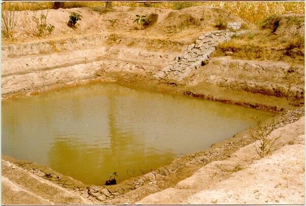
A sunken structure (12 x 12 x 3 m, more suiable), constructed by escavation in arable land with a view of temporary runoff storage tapped for protective irrigation, and to increase percolation for recharge of ground water (to convert surface to subsurface flow)
2.2 Detailed description of the Technology
Description:
A farm pond comprises of excavated portions of 12 x 12 x 3 m with the steps at 0.6m depth each. The excavated earth is deposited all around the structure as a bund, with a burm space of 1m. An inlet cum outlet provided in the course of flow of rain water to collect and dispose the excess runoff.
Purpose of the Technology: (1). For storage of exess runoff. (2) to increase percolation for ground water recharge, (3). To use for protective irrigation during dry period, (4). To stop further deepening of watercourse in arable lands
Establishment / maintenance activities and inputs: Selection of beneficiary is by the community and site selection, Design/ layout and excavation by the project staff with participation of the beneficiary. Desilting of the structure is by the beneficiary
Natural / human environment: surrounding lands are more slopy and with exposed rocks, most of the surrounding area is left for grazing
2.3 Photos of the Technology
Media Gallery
2.5 Country/ region/ locations where the Technology has been applied and which are covered by this assessment
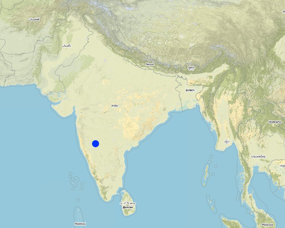
Country:
India
Region/ State/ Province:
Karnataka
Further specification of location:
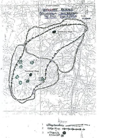
Bijapur district, Hadalsang village
Specify the spread of the Technology:
- evenly spread over an area
If the Technology is evenly spread over an area, specify area covered (in km2):
0.028
If precise area is not known, indicate approximate area covered:
- < 0.1 km2 (10 ha)
Comments:
Total area covered by the SLM Technology is 0.028 km2.
The technology area comprising of 2.8 ha within the overall watershed area of 2458 ha. The technology is useful in harvesting the excess rainwater in the arable land and re-use the for protective irigation after the rainy period.
Map
×2.6 Date of implementation
If precise year is not known, indicate approximate date:
- less than 10 years ago (recently)
2.7 Introduction of the Technology
Specify how the Technology was introduced:
- through projects/ external interventions
Comments (type of project, etc.):
Department of Agriculture, Govet. Of Karnataka
3. Classification of the SLM Technology
3.1 Main purpose(s) of the Technology
- improve production
- conserve ecosystem
- adapt to climate change/ extremes and its impacts
3.2 Current land use type(s) where the Technology is applied

Cropland
- Annual cropping
Annual cropping - Specify crops:
- cereals - sorghum
- legumes and pulses - other
- oilseed crops - castor
- Chili, brinjal (eggplants), lady's finger (okra, kind of peas)
Number of growing seasons per year:
- 2
Specify:
Longest growing period in days: 120 Longest growing period from month to month: Sep - Dec Second longest growing period in days: 90 Second longest growing period from month to month: Jul - Sep
Comments:
Major land use problems (compiler’s opinion): The lands are very undulating (Class-V as per the Land Capability Classification), with very shallow soils, feasible for only one rainfed crops.
Major land use problems (land users’ perception): Poor yields due to shallow soils that too only one crop in one season, undulating lands leading to more runoff.
Type of cropping system and major crops comments: minor pulses - cereals (green gram-jowar)
Constraints of wastelands / deserts / glaciers / swamps: Highly eroded, unsuitable for any production purposes.
3.4 Water supply
Water supply for the land on which the Technology is applied:
- rainfed
Comments:
Water supply: Also mixed rainfed - irrigated (ranked 2)
3.5 SLM group to which the Technology belongs
- water harvesting
- irrigation management (incl. water supply, drainage)
3.6 SLM measures comprising the Technology
3.7 Main types of land degradation addressed by the Technology

soil erosion by water
- Wt: loss of topsoil/ surface erosion
- Wg: gully erosion/ gullying
- Wo: offsite degradation effects
Comments:
Main type of degradation addressed: Wt: loss of topsoil / surface erosion
Secondary types of degradation addressed: Wg: gully erosion / gullying, Wo: offsite degradation effects
Main causes of degradation: other natural causes (avalanches, volcanic eruptions, mud flows, highly susceptible natural resources, extreme topography, etc.) specify, poverty / wealth (lack of captial)
Secondary causes of degradation: other human induced causes (specify) (other (migration)), labour availability (lack of labour, cost of labour), education, access to knowledge and support services (lack of knowledge)
3.8 Prevention, reduction, or restoration of land degradation
Specify the goal of the Technology with regard to land degradation:
- prevent land degradation
- reduce land degradation
Comments:
Main goals: mitigation / reduction of land degradation
Secondary goals: prevention of land degradation
4. Technical specifications, implementation activities, inputs, and costs
4.1 Technical drawing of the Technology

Technical specifications (related to technical drawing):
The drawing showing the details of the farm pond. 12 x 12 x 3 m dimension. Five steps cutting on each side with 1:1 side slope. 1m birm (space) between the earthen bund. 1m wide spilway inlet cum outlet at suitable place of the site.
Location: Kallahalla nala watershed, Indi Taluk. Bijapur district of Karnataka state
Date: 20.4.2004
Technical knowledge required for field staff / advisors: moderate
Technical knowledge required for land users: high
Main technical functions: water harvesting / increase water supply
Secondary technical functions: increase of infiltration, increase / maintain water stored in soil
Structural measure: sediment sand / trap
Depth of ditches/pits/dams (m): 3
Width of ditches/pits/dams (m): 15
Length of ditches/pits/dams (m): 15
Height of bunds/banks/others (m): 1
Width of bunds/banks/others (m): 1
Length of bunds/banks/others (m): 15
Construction material (earth): soil excavated from the pond is used to for bunds all around the structure with 1 m birm space.
Construction material (stone): The spillway Inlet cum Outlet is constructed using stones
For water harvesting: the ratio between the area where the harvested water is applied and the total area from which water is collected is: 1:7
Vegetation is used for stabilisation of structures.
Author:
C.G Metri, JPO, KWDP Danida Bi
4.2 General information regarding the calculation of inputs and costs
other/ national currency (specify):
Ruppes
If relevant, indicate exchange rate from USD to local currency (e.g. 1 USD = 79.9 Brazilian Real): 1 USD =:
46.0
Indicate average wage cost of hired labour per day:
0.73
4.3 Establishment activities
| Activity | Timing (season) | |
|---|---|---|
| 1. | selection of site and survey, preparation of estimates | summer |
| 2. | submission for sanction of approval | summer |
| 3. | Excavation of the farmpond | summer |
| 4. | construction of inlet/ outlet | before monsoon starts |
4.4 Costs and inputs needed for establishment
| Specify input | Unit | Quantity | Costs per Unit | Total costs per input | % of costs borne by land users | |
|---|---|---|---|---|---|---|
| Labour | Labour | ha | 1.0 | 360.0 | 360.0 | 10.0 |
| Construction material | Stone | ha | 1.0 | 109.43 | 109.43 | 100.0 |
| Total costs for establishment of the Technology | 469.43 | |||||
| Total costs for establishment of the Technology in USD | 10.21 | |||||
Comments:
Duration of establishment phase: 0 month(s)
4.5 Maintenance/ recurrent activities
| Activity | Timing/ frequency | |
|---|---|---|
| 1. | Meeting with the farmer | monsoon/annual |
| 2. | Desilting of farmpond | summer season/once in 2 years |
| 3. | Repair of Inlet/Outlet | summer season/Every year |
| 4. | Trimming of Bund | summer season/Every year |
4.6 Costs and inputs needed for maintenance/ recurrent activities (per year)
| Specify input | Unit | Quantity | Costs per Unit | Total costs per input | % of costs borne by land users | |
|---|---|---|---|---|---|---|
| Labour | Labour | ha | 1.0 | 7.3 | 7.3 | 100.0 |
| Total costs for maintenance of the Technology | 7.3 | |||||
| Total costs for maintenance of the Technology in USD | 0.16 | |||||
Comments:
12 m x 12 m x 3 m size with all side slope of 1:1 (five steps of 0.6 m deep), Inlet cum outlet spilway constructed with stones. This indicates only the actual cost of construction. (excavation / earth wotk and stone work for inlet/outlet)
4.7 Most important factors affecting the costs
Describe the most determinate factors affecting the costs:
If the implementation site is having the hard strata, then the cost will be more.
5. Natural and human environment
5.1 Climate
Annual rainfall
- < 250 mm
- 251-500 mm
- 501-750 mm
- 751-1,000 mm
- 1,001-1,500 mm
- 1,501-2,000 mm
- 2,001-3,000 mm
- 3,001-4,000 mm
- > 4,000 mm
Specify average annual rainfall (if known), in mm:
550.00
Agro-climatic zone
- semi-arid
Located on the latitude 16-49'N and longitude 75-43'E .Characterised by hot dry summer (42 °C) and cold dry winters monsoon (July-September) is characterised by high intensity showers followed by pro
5.2 Topography
Slopes on average:
- flat (0-2%)
- gentle (3-5%)
- moderate (6-10%)
- rolling (11-15%)
- hilly (16-30%)
- steep (31-60%)
- very steep (>60%)
Landforms:
- plateau/plains
- ridges
- mountain slopes
- hill slopes
- footslopes
- valley floors
Altitudinal zone:
- 0-100 m a.s.l.
- 101-500 m a.s.l.
- 501-1,000 m a.s.l.
- 1,001-1,500 m a.s.l.
- 1,501-2,000 m a.s.l.
- 2,001-2,500 m a.s.l.
- 2,501-3,000 m a.s.l.
- 3,001-4,000 m a.s.l.
- > 4,000 m a.s.l.
Comments and further specifications on topography:
Altitudinal zone: 501-1000 m a.s.l. (594 m a.s.l.)
Slopes on average: Gentle (ridge and valley portion)
5.3 Soils
Soil depth on average:
- very shallow (0-20 cm)
- shallow (21-50 cm)
- moderately deep (51-80 cm)
- deep (81-120 cm)
- very deep (> 120 cm)
Soil texture (topsoil):
- medium (loamy, silty)
Topsoil organic matter:
- low (<1%)
If available, attach full soil description or specify the available information, e.g. soil type, soil PH/ acidity, Cation Exchange Capacity, nitrogen, salinity etc.
Soil depth on average: Shallow (30 cm)
Soil texture: Medium (medium in valley portion)
Soil fertility: Low (along the slope of the ridge, ranked 1) and medium (valley portion, ranked 2)
Topsoil organic matter: Low (in valley portion)
Soil water storage capacity: Low (hill portion, ranked 1) and medium (valley portion, ranked 2)
5.6 Characteristics of land users applying the Technology
Market orientation of production system:
- mixed (subsistence/ commercial)
Off-farm income:
- 10-50% of all income
Relative level of wealth:
- poor
Indicate other relevant characteristics of the land users:
Population density: 100-200 persons/km2
Annual population growth: 3% - 4%
15% of the land users are very rich and own 5% of the land.
25% of the land users are rich and own 20% of the land.
50% of the land users are average wealthy and own 50% of the land.
10% of the land users are poor and own 15% of the land.
and own 10% of the land.
Off-farm income specification: Through sheep and goat rearing
Level of mechanization: Animal traction, (ranked 1, for ploughing, seed sowing harrowing), manual work (ranked 2, clod crushing, harvesting, threashing) and mechanised (ranked 3, Deep ploughing, levelling)
5.7 Average area of land used by land users applying the Technology
- < 0.5 ha
- 0.5-1 ha
- 1-2 ha
- 2-5 ha
- 5-15 ha
- 15-50 ha
- 50-100 ha
- 100-500 ha
- 500-1,000 ha
- 1,000-10,000 ha
- > 10,000 ha
Comments:
Average area of land owned or leased by land users applying the Technology:
1-2 ha (ranked 1, marginal farmers [since the land holding decreases because of the fractionation the production and productivity also reduces])
2-5 ha (ranked 2, small farmers)
5-15 ha (ranked 3, big famers)
5.8 Land ownership, land use rights, and water use rights
Land ownership:
- individual, titled
Land use rights:
- individual
6. Impacts and concluding statements
6.1 On-site impacts the Technology has shown
Socio-economic impacts
Production
crop production
Comments/ specify:
Second crop also taken
fodder production
Comments/ specify:
From trees
fodder quality
Comments/ specify:
From trees
product diversity
Comments/ specify:
Difference in the crop like on bunds and in the patches of crops.
production area
Comments/ specify:
15m x 15m land loss average land holding is very less, thus small & marginal farmers face reduction in the production area with this SWC
land management
Comments/ specify:
After implementing SWC less area is left for very small and marginal land holding.
Water availability and quality
water availability for livestock
Income and costs
farm income
Comments/ specify:
Subsistance agriculture
Other socio-economic impacts
Input constraints
Comments/ specify:
To bring new area into cultivation
Socio-cultural impacts
SLM/ land degradation knowledge
Ecological impacts
Water cycle/ runoff
excess water drainage
Soil
soil moisture
soil cover
soil loss
Other ecological impacts
Soil fertility
6.2 Off-site impacts the Technology has shown
reliable and stable stream flows in dry season
downstream flooding
Comments/ specify:
Water storage in farm pond
6.4 Cost-benefit analysis
How do the benefits compare with the establishment costs (from land users’ perspective)?
Short-term returns:
positive
Long-term returns:
positive
How do the benefits compare with the maintenance/ recurrent costs (from land users' perspective)?
Short-term returns:
positive
Long-term returns:
positive
6.5 Adoption of the Technology
Comments:
There is a little trend towards spontaneous adoption of the Technology
Comments on adoption trend: The community is motivated with the benefits from this SWC structure. Some of them have already deepened the farmponds to increase its storage capacity.However, since most of the farmers are having very small land holdings and there was continous dry season from last three years, even if the farmers are motivated and aware of the technology of farmpond, they could not take up on their own (without financial assistance from the project.
6.7 Strengths/ advantages/ opportunities of the Technology
| Strengths/ advantages/ opportunities in the land user’s view |
|---|
|
Increased storage of water How can they be sustained / enhanced? Desilting by the farmer |
| Reduce gully formation |
|
Bring more area under irrigation How can they be sustained / enhanced? By giving life saving irrigation |
|
Economic benefits How can they be sustained / enhanced? By yields (monocropping to multiple cropping) --> more income |
|
Recycle the silt is beneficial How can they be sustained / enhanced? Other the silt would been lost every year and it is good to retain the soil fertility. |
| Strengths/ advantages/ opportunities in the compiler’s or other key resource person’s view |
|---|
|
Storage of water How can they be sustained / enhanced? By deepening |
|
Reduced runoff velocity How can they be sustained / enhanced? By mentainance |
|
Breaching of bunds down stream How can they be sustained / enhanced? By reducing the run-off |
|
Replicability How can they be sustained / enhanced? if a famer has his own labour/ man power then he can go for its construction. |
|
Water harvesting How can they be sustained / enhanced? recycle for protective irrigation during peak season. |
6.8 Weaknesses/ disadvantages/ risks of the Technology and ways of overcoming them
| Weaknesses/ disadvantages/ risks in the land user’s view | How can they be overcome? |
|---|---|
| Inability to contribute 100% towards cost of construction. | By giving schemes / financial assistance |
| Loosing of portion of cultivable land | By utilizing bunds, change in cropping system/ cropping pattern etc. |
| Weaknesses/ disadvantages/ risks in the compiler’s or other key resource person’s view | How can they be overcome? |
|---|---|
| Difficult to excavate in hard strata | can be done in shallow soils |
| Silt accumulation, if upper catchment is not treated | Treatment of upper catchment |
7. References and links
7.1 Methods/ sources of information
7.2 References to available publications
Title, author, year, ISBN:
Department Guidelines,Project Implementation plan, UAS Dharwad
Available from where? Costs?
In the office, personal contact
Title, author, year, ISBN:
PIP
Available from where? Costs?
in the office
Title, author, year, ISBN:
University of Agril. Sciences Dharwad
Available from where? Costs?
personal contact
Links and modules
Expand all Collapse allLinks
Stakeholders participation in the project activities [India]
SWC approach is a participatory methodology to empower the community to plan, implement, monitor, evaluate and manage the SWC technology to bring about sustainability
- Compiler: Pranesh Jahagirdar
Modules
No modules