Road runoff system - Mwingi [Kenya]
- Creation:
- Update:
- Compiler: Kithinji Mutunga
- Editor: –
- Reviewers: David Streiff, Alexandra Gavilano
Kuketha kiwuo
technologies_1483 - Kenya
View sections
Expand all Collapse all1. General information
1.2 Contact details of resource persons and institutions involved in the assessment and documentation of the Technology
Key resource person(s)
State employee:
1.3 Conditions regarding the use of data documented through WOCAT
The compiler and key resource person(s) accept the conditions regarding the use of data documented through WOCAT:
Yes
2. Description of the SLM Technology
2.1 Short description of the Technology
Definition of the Technology:
Diversion of runoff from the road and its environment into farm land
2.2 Detailed description of the Technology
Description:
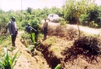
Diversion channel to harvest run off water from the road catchment. Individually constructed and maintained. The runoff water harvesting has a rainfall "multiplier " effect because it closes the gap between the actual precipition and the crop water requirement. Maintenance (reconditioning) is done mainly during the land preparation in the dry spell. The run is collected and distributed on the cultivated lad through canal systems. This technolgy is meant for semi arid conditions. It can also be applied in the good rainfall areas during poor seasons with crop moisture deficiency particularly during dry speells.
2.3 Photos of the Technology
Media Gallery

2.5 Country/ region/ locations where the Technology has been applied and which are covered by this assessment
Country:
Kenya
Region/ State/ Province:
Eastern - Mwingi District
Specify the spread of the Technology:
- evenly spread over an area
If precise area is not known, indicate approximate area covered:
- 100-1,000 km2
Comments:
A farmer initiative technology
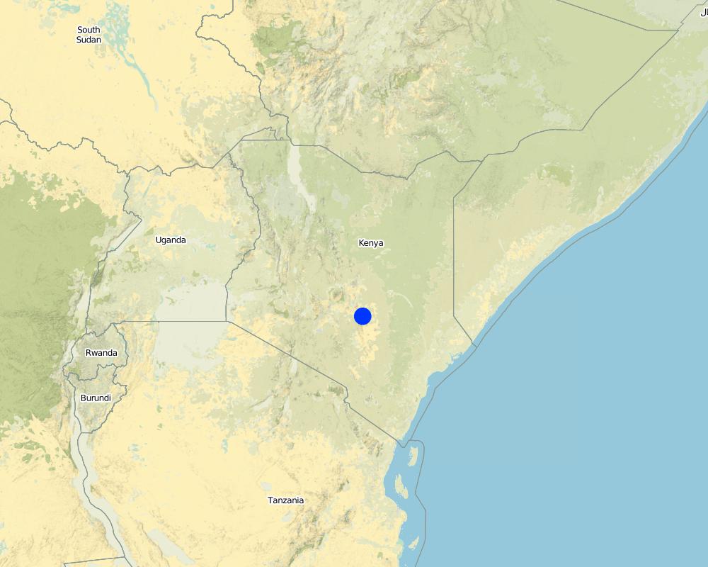
Map
×2.6 Date of implementation
If precise year is not known, indicate approximate date:
- less than 10 years ago (recently)
2.7 Introduction of the Technology
Specify how the Technology was introduced:
- through land users' innovation
Comments (type of project, etc.):
Own initiative and innovativeness
3. Classification of the SLM Technology
3.1 Main purpose(s) of the Technology
- reduce, prevent, restore land degradation
3.2 Current land use type(s) where the Technology is applied

Grazing land
Comments:
Number of growing seasons per year: 2
Longest growing period in days: 105 Longest growing period from month to month: Oct - Jan Second longest growing period in days: 85Second longest growing period from month to month: Mar - May
Major land use problems (compiler’s opinion): Erratic rainfall for crop production and vegetative cover for livestock and declining fertility
Major land use problems (land users’ perception): Low rainfall, poor yields and little grass for livestock, and high cost of inputs
3.4 Water supply
Water supply for the land on which the Technology is applied:
- rainfed
3.5 SLM group to which the Technology belongs
- water diversion and drainage
3.6 SLM measures comprising the Technology

structural measures
- S4: Level ditches, pits
Comments:
Main measures: structural measures
3.7 Main types of land degradation addressed by the Technology

chemical soil deterioration
- Cn: fertility decline and reduced organic matter content (not caused by erosion)

water degradation
- Ha: aridification
Comments:
Main type of degradation addressed: Ha: aridification
Secondary types of degradation addressed: Cn: fertility decline and reduced organic matter content
3.8 Prevention, reduction, or restoration of land degradation
Specify the goal of the Technology with regard to land degradation:
- reduce land degradation
4. Technical specifications, implementation activities, inputs, and costs
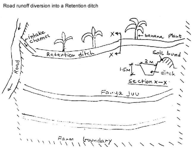
4.1 Technical drawing of the Technology
Technical specifications (related to technical drawing):
Technical knowledge required for field staff / advisors: low
Technical knowledge required for land users: low
Main technical functions: control of concentrated runoff: retain / trap, control of concentrated runoff: impede / retard, control of concentrated runoff: drain / divert, improvement of ground cover, increase of infiltration, increase / maintain water stored in soil, water harvesting / increase water supply
Secondary technical functions: sediment retention / trapping, sediment harvesting
Construction material (other): *Diversion ditch /COD gradient along the structure 0.25%
4.2 General information regarding the calculation of inputs and costs
other/ national currency (specify):
Kenya Shilling
If relevant, indicate exchange rate from USD to local currency (e.g. 1 USD = 79.9 Brazilian Real): 1 USD =:
27.0
Indicate average wage cost of hired labour per day:
2.22
4.3 Establishment activities
| Activity | Timing (season) | |
|---|---|---|
| 1. | excavation | before rains |
| 2. | alignment/finishing | during the rains |
4.4 Costs and inputs needed for establishment
Comments:
Duration of establishment phase: 12 month(s)
4.5 Maintenance/ recurrent activities
| Activity | Timing/ frequency | |
|---|---|---|
| 1. | desilting | during rains/on demand |
| 2. | desilting | dry spell/once |
4.6 Costs and inputs needed for maintenance/ recurrent activities (per year)
Comments:
per metre length of the structure
4.7 Most important factors affecting the costs
Describe the most determinate factors affecting the costs:
slope determine the depth of the channel and soil type and distance from the road to the farm determines labour requirements
5. Natural and human environment
5.1 Climate
Annual rainfall
- < 250 mm
- 251-500 mm
- 501-750 mm
- 751-1,000 mm
- 1,001-1,500 mm
- 1,501-2,000 mm
- 2,001-3,000 mm
- 3,001-4,000 mm
- > 4,000 mm
Agro-climatic zone
- semi-arid
Thermal climate class: tropics
5.2 Topography
Slopes on average:
- flat (0-2%)
- gentle (3-5%)
- moderate (6-10%)
- rolling (11-15%)
- hilly (16-30%)
- steep (31-60%)
- very steep (>60%)
Landforms:
- plateau/plains
- ridges
- mountain slopes
- hill slopes
- footslopes
- valley floors
Altitudinal zone:
- 0-100 m a.s.l.
- 101-500 m a.s.l.
- 501-1,000 m a.s.l.
- 1,001-1,500 m a.s.l.
- 1,501-2,000 m a.s.l.
- 2,001-2,500 m a.s.l.
- 2,501-3,000 m a.s.l.
- 3,001-4,000 m a.s.l.
- > 4,000 m a.s.l.
Comments and further specifications on topography:
Slopes on average: Also gentle
5.3 Soils
Soil depth on average:
- very shallow (0-20 cm)
- shallow (21-50 cm)
- moderately deep (51-80 cm)
- deep (81-120 cm)
- very deep (> 120 cm)
Soil texture (topsoil):
- coarse/ light (sandy)
- medium (loamy, silty)
Topsoil organic matter:
- low (<1%)
If available, attach full soil description or specify the available information, e.g. soil type, soil PH/ acidity, Cation Exchange Capacity, nitrogen, salinity etc.
Soil depth on average: Also deep
Soil fertility is low
Soil drainage / infiltration is good
Soil water storage capacity is medium
5.6 Characteristics of land users applying the Technology
Off-farm income:
- less than 10% of all income
Relative level of wealth:
- poor
- average
Level of mechanization:
- manual work
- animal traction
Indicate other relevant characteristics of the land users:
Population density: 10-50 persons/km2
Annual population growth: 2% - 3%
60% of the land users are average wealthy and own 60% of the land.
30% of the land users are poor and own 30% of the land.
10% of the land users are poor and own 10% of the land.
Off-farm income specification: employment outside the farm and area
5.8 Land ownership, land use rights, and water use rights
Land ownership:
- communal/ village
- individual, titled
Land use rights:
- communal (organized)
- individual
6. Impacts and concluding statements
6.1 On-site impacts the Technology has shown
Ecological impacts
Water cycle/ runoff
surface runoff
Quantity before SLM:
80
Quantity after SLM:
10
Soil
soil loss
Quantity before SLM:
12
Quantity after SLM:
2
6.4 Cost-benefit analysis
How do the benefits compare with the establishment costs (from land users’ perspective)?
Short-term returns:
positive
Long-term returns:
very positive
How do the benefits compare with the maintenance/ recurrent costs (from land users' perspective)?
Short-term returns:
positive
Long-term returns:
very positive
6.5 Adoption of the Technology
- 1-10%
If available, quantify (no. of households and/ or area covered):
30 households
Of all those who have adopted the Technology, how many did so spontaneously, i.e. without receiving any material incentives/ payments?
- 91-100%
Comments:
Comments on acceptance with external material support: estimates
10% of land user families have adopted the Technology without any external material support
30 land user families have adopted the Technology without any external material support
Comments on spontaneous adoption: estimates
There is a moderate trend towards spontaneous adoption of the Technology
Comments on adoption trend: more land users are harvesting runoff from the road
7. References and links
7.1 Methods/ sources of information
7.2 References to available publications
Title, author, year, ISBN:
Kenya population census. 1989.
Available from where? Costs?
CBS, Nairobi
Title, author, year, ISBN:
SWC manual for Kenya. 1997.
Available from where? Costs?
SWCB/MoA, Nairobi
Title, author, year, ISBN:
Farm managent handbook of Kenya. 1983.
Available from where? Costs?
FMD/MoA, Nairobi
Links and modules
Expand all Collapse allLinks
No links
Modules
No modules