Pitting - Machakos experience [Kenya]
- Creation:
- Update:
- Compiler: Paul Mutuku Kimeu
- Editor: –
- Reviewer: David Streiff
Wamatengo pits, Kitui Pitting, Katumani pitting
technologies_1484 - Kenya
View sections
Expand all Collapse all1. General information
1.2 Contact details of resource persons and institutions involved in the assessment and documentation of the Technology
1.3 Conditions regarding the use of data documented through WOCAT
When were the data compiled (in the field)?
05/05/1999
The compiler and key resource person(s) accept the conditions regarding the use of data documented through WOCAT:
Yes
2. Description of the SLM Technology
2.1 Short description of the Technology
Definition of the Technology:
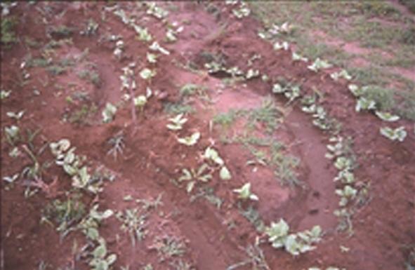
A system of interlocking crescent shaped trenches approximately 5-12 square metres, 0.5 m deep and 0.3 m high formed down slope using the xecavated spoil
2.2 Detailed description of the Technology
Description:
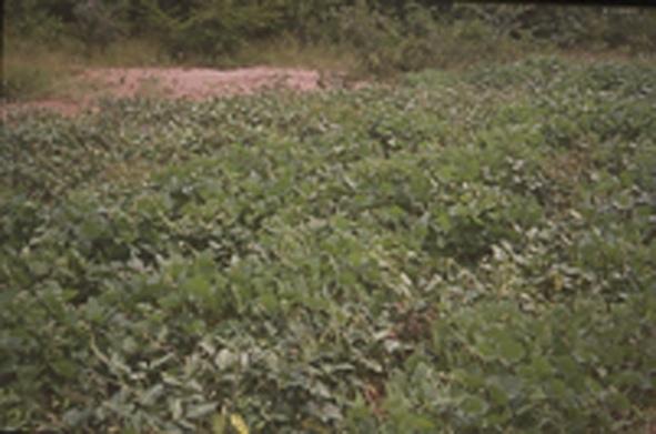
The pitting is started at the top of the eroded slope or below a cutoff drain which interced all runoff from the above land. The pits are roughly circular in shape and are dug to form interlocking micro catchment, each about 2m squared in area. A semi circular bank 15 - 30cm high is constructed to the lower side of the pit using soil removed from the trench. At the centre of each trench, a hole is excavated to a depth of at least 50cm to act as the main reservoir for runoff water from the catchment above. The pit are used for soil conservation and rehabilitation of the grazingland. Runoff is captured in small quantities, thus preventing the build up of large erosive flows. Cowpeas, grass could be sown on the ridges at onset of the rains. Construction is by hoes and once the vegetation has established, maintenance is minimal. Forage should be cut and fed to animals. The technology is suitable in areas with 6-8% slope in areas with 500-800mm rainfall. There is need to maintain the cutoff drain after a rainy season
2.3 Photos of the Technology
Media Gallery
2.5 Country/ region/ locations where the Technology has been applied and which are covered by this assessment
Country:
Kenya
Region/ State/ Province:
Eastern Province
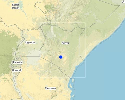
Map
×2.6 Date of implementation
If precise year is not known, indicate approximate date:
- less than 10 years ago (recently)
2.7 Introduction of the Technology
Specify how the Technology was introduced:
- during experiments/ research
Comments (type of project, etc.):
based on similar technology from the neighbouring Kitui and also Tanzania (Matengo Pits)
3. Classification of the SLM Technology
3.1 Main purpose(s) of the Technology
- reduce, prevent, restore land degradation
3.2 Current land use type(s) where the Technology is applied

Grazing land
Comments:
Major land use problems (compiler’s opinion): erosion in the unprotected grazing areas
Major land use problems (land users’ perception): lack of adequate fodder for livestock
Grazingland comments: there is an increasing trend towards closing off grazing areas to avoid interference by neighbours and to improve forage productivity.
Type of grazing system comments: there is an increasing trend towards closing off grazing areas to avoid interference by neighbours and to improve forage productivity.
3.3 Further information about land use
Water supply for the land on which the Technology is applied:
- rainfed
Number of growing seasons per year:
- 2
Specify:
Longest growing period in days: 43 Longest growing period from month to month: Oct - DecSecond longest growing period in days: 34Second longest growing period from month to month: Mar - Jul
3.4 SLM group to which the Technology belongs
- water diversion and drainage
3.5 Spread of the Technology
Specify the spread of the Technology:
- evenly spread over an area
If the Technology is evenly spread over an area, indicate approximate area covered:
- < 0.1 km2 (10 ha)
Comments:
these were research trial plots.
3.6 SLM measures comprising the Technology

structural measures
- S2: Bunds, banks
- S4: Level ditches, pits
Comments:
Main measures: structural measures
3.7 Main types of land degradation addressed by the Technology

soil erosion by water
- Wt: loss of topsoil/ surface erosion

chemical soil deterioration
- Cn: fertility decline and reduced organic matter content (not caused by erosion)

water degradation
- Ha: aridification
Comments:
Main type of degradation addressed: Wt: loss of topsoil / surface erosion, Ha: aridification
Secondary types of degradation addressed: Cn: fertility decline and reduced organic matter content
3.8 Prevention, reduction, or restoration of land degradation
Specify the goal of the Technology with regard to land degradation:
- reduce land degradation
4. Technical specifications, implementation activities, inputs, and costs
4.1 Technical drawing of the Technology

4.2 Technical specifications/ explanations of technical drawing
Technical knowledge required for field staff / advisors: moderate
Technical knowledge required for land users: moderate
Main technical functions: control of dispersed runoff: retain / trap, improvement of ground cover, water harvesting / increase water supply
Secondary technical functions: control of raindrop splash, increase in organic matter, increase of infiltration
Construction material (earth): this is the spoil obtained from the excavation
Vegetation is used for stabilisation of structures.
Change of land use type: during establishment of grass/legume
4.3 General information regarding the calculation of inputs and costs
other/ national currency (specify):
Kenya Shilling
Indicate exchange rate from USD to local currency (if relevant): 1 USD =:
78.0
Indicate average wage cost of hired labour per day:
2.56
4.4 Establishment activities
| Activity | Type of measure | Timing | |
|---|---|---|---|
| 1. | reseeding grass | Structural | rainy days |
| 2. | pit excavation | Structural | before rains |
| 3. | bund formation | Structural | before rains |
| 4. | legume planting | Structural | before rains |
| 5. | fencing | Management | before rains |
4.5 Costs and inputs needed for establishment
Comments:
Duration of establishment phase: 36 month(s)
4.6 Maintenance/ recurrent activities
| Activity | Type of measure | Timing/ frequency | |
|---|---|---|---|
| 1. | repair pits | Structural | after rains/twice |
| 2. | desilt of cutoff drains | Structural | before rains/each cropping season |
| 3. | sealing gaps on the fence | Management | during the rain / twice |
4.7 Costs and inputs needed for maintenance/ recurrent activities (per year)
Comments:
the costs were calculated based on the construction of a cutoff drain, fencing and pits
4.8 Most important factors affecting the costs
Describe the most determinate factors affecting the costs:
when cutoff drain is to be constructed, particularly in the dry spell when the ground is hard. When the construction is done when the ground is too hard the cost of labour is high.
5. Natural and human environment
5.1 Climate
Annual rainfall
- < 250 mm
- 251-500 mm
- 501-750 mm
- 751-1,000 mm
- 1,001-1,500 mm
- 1,501-2,000 mm
- 2,001-3,000 mm
- 3,001-4,000 mm
- > 4,000 mm
Agro-climatic zone
- semi-arid
Thermal climate class: tropics
5.2 Topography
Slopes on average:
- flat (0-2%)
- gentle (3-5%)
- moderate (6-10%)
- rolling (11-15%)
- hilly (16-30%)
- steep (31-60%)
- very steep (>60%)
Landforms:
- plateau/plains
- ridges
- mountain slopes
- hill slopes
- footslopes
- valley floors
Altitudinal zone:
- 0-100 m a.s.l.
- 101-500 m a.s.l.
- 501-1,000 m a.s.l.
- 1,001-1,500 m a.s.l.
- 1,501-2,000 m a.s.l.
- 2,001-2,500 m a.s.l.
- 2,501-3,000 m a.s.l.
- 3,001-4,000 m a.s.l.
- > 4,000 m a.s.l.
5.3 Soils
Soil depth on average:
- very shallow (0-20 cm)
- shallow (21-50 cm)
- moderately deep (51-80 cm)
- deep (81-120 cm)
- very deep (> 120 cm)
Soil texture (topsoil):
- medium (loamy, silty)
- fine/ heavy (clay)
Topsoil organic matter:
- medium (1-3%)
- low (<1%)
If available, attach full soil description or specify the available information, e.g. soil type, soil PH/ acidity, Cation Exchange Capacity, nitrogen, salinity etc.
Soil depth on average: Also moderatly
Soil fertility: Very low - medium
Soil water storage capacity: Medium - high
5.6 Characteristics of land users applying the Technology
Off-farm income:
- > 50% of all income
Relative level of wealth:
- poor
- average
Indicate other relevant characteristics of the land users:
Population density: 100-200 persons/km2
Annual population growth: 3% - 4%
5% of the land users are rich and own 30% of the land.
25% of the land users are average wealthy and own 35% of the land.
45% of the land users are poor and own 25% of the land.
20% of the land users are poor and own 10% of the land.
Off-farm income specification: most of the adult have moved to town to look for employment.
5.8 Land ownership, land use rights, and water use rights
Land ownership:
- individual, not titled
- individual, titled
Land use rights:
- individual
6. Impacts and concluding statements
6.1 On-site impacts the Technology has shown
Ecological impacts
Soil
soil loss
Quantity before SLM:
20.5
Quantity after SLM:
7
6.4 Cost-benefit analysis
How do the benefits compare with the establishment costs (from land users’ perspective)?
Short-term returns:
slightly positive
Long-term returns:
positive
How do the benefits compare with the maintenance/ recurrent costs (from land users' perspective)?
Short-term returns:
positive
Long-term returns:
positive
6.5 Adoption of the Technology
If available, quantify (no. of households and/ or area covered):
NA
Comments:
Comments on acceptance with external material support: estimates
7. References and links
7.2 References to available publications
Title, author, year, ISBN:
some aspects of soil conservation on grazing lands in Thomas , D B et al. SWC in Kenya. 1989.
Links and modules
Expand all Collapse allLinks
No links
Modules
No modules