
Kitui Sand dams [Kenya]
- Creation:
- Update:
- Compiler: Unknown User
- Editor: –
- Reviewers: David Streiff, Alexandra Gavilano
Mung'eeto (KIKAMBA)
technologies_1486 - Kenya
View sections
Expand all Collapse all1. General information
1.3 Conditions regarding the use of data documented through WOCAT
The compiler and key resource person(s) accept the conditions regarding the use of data documented through WOCAT:
Yes
1.5 Reference to Questionnaire(s) on SLM Approaches (documented using WOCAT)
SASOL community approach - for sand dams in … [Kenya]
Community based water resource development
- Compiler: Donald B. Thomas
2. Description of the SLM Technology
2.1 Short description of the Technology
Definition of the Technology:
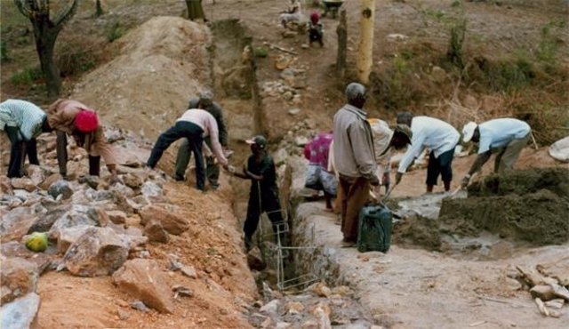
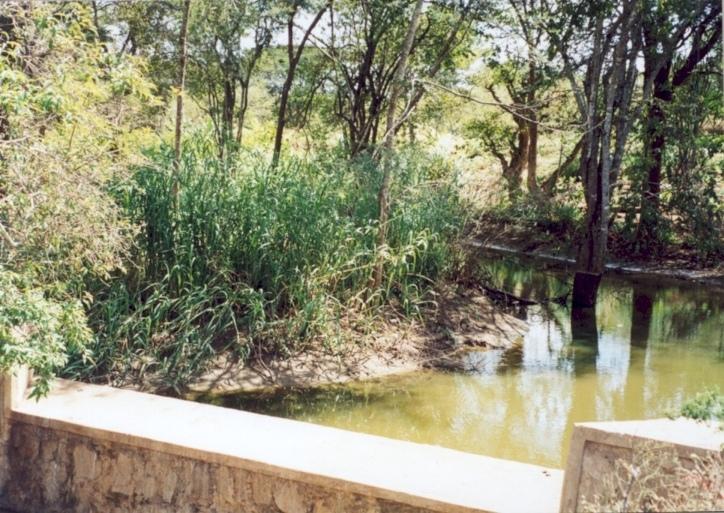
Masonry dam in seasonal watercourse or river that stores water in the sand which accumulates above it.
2.2 Detailed description of the Technology
Description:
The dams are usually constructed where there is a rock bar in the river bed. The dam wall is raised 1.5 - 2.0 M above the level of sand.They fill up quickly with sand in which water is stored. The sand reduces the rate of evaporation and about 30% of the volume can store water for use in the dry season. If the dam is well constructed, maintenance is minimal. The dams are especially useful in semi-arid areas with catchments that provides plenty of coarse sand to fill up the reservoir.
2.3 Photos of the Technology
Media Gallery
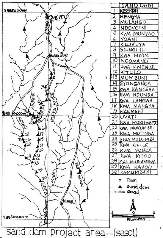

2.5 Country/ region/ locations where the Technology has been applied and which are covered by this assessment
Country:
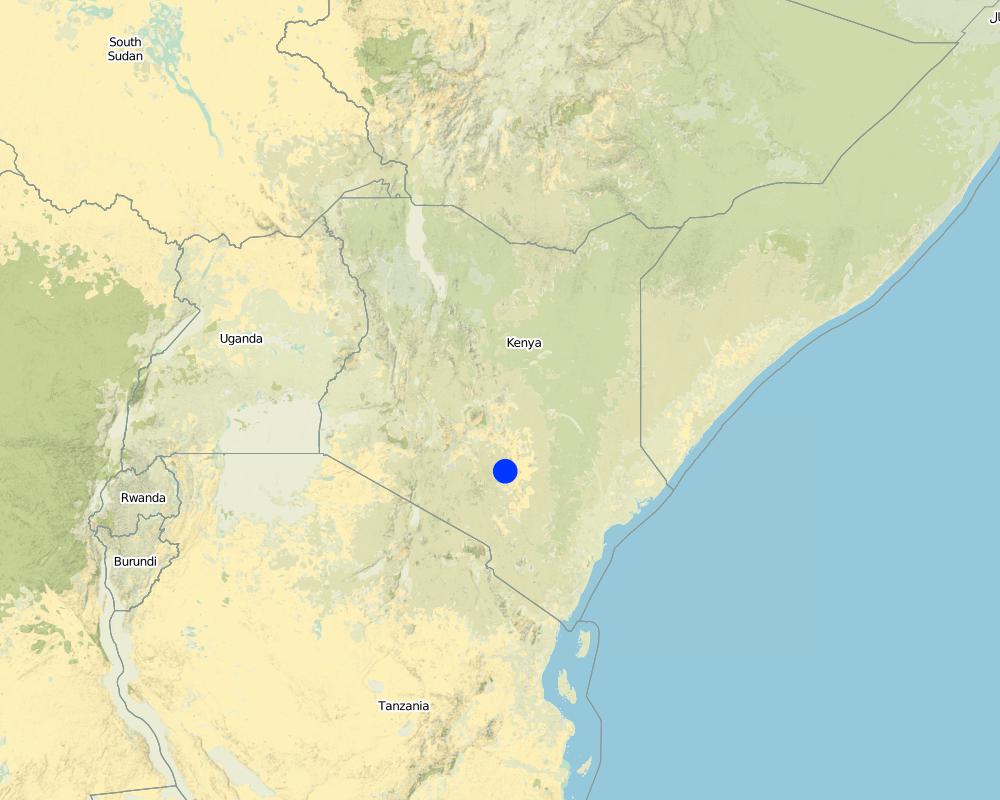
Kenya
Region/ State/ Province:
Eastern
Comments:
Total area covered by the SLM Technology is 200 m2.
The area was selected because of the need for water in the dry season and the density of population to implement the sand dam construction
Map
×2.6 Date of implementation
If precise year is not known, indicate approximate date:
- less than 10 years ago (recently)
2.7 Introduction of the Technology
Specify how the Technology was introduced:
- through projects/ external interventions
Comments (type of project, etc.):
Introduced in semi arid regions of kenya by the colonial government to increase water availabilty during the dry period through construction of masonary barrier across ephemeral rivers.
3. Classification of the SLM Technology
3.1 Main purpose(s) of the Technology
- adapt to climate change/ extremes and its impacts
3.2 Current land use type(s) where the Technology is applied

Waterways, waterbodies, wetlands
- Ponds, dams
Comments:
Major land use problems (compiler’s opinion): Semi-arid conditions with frequent failure of rains and experience water availabilty problems during dry period. High incidence of both on-farm soil erosion.
Major land use problems (land users’ perception): drought , insufficient rains, water scacity.
Number of growing seasons per year: 2
Longest growing period in days: 60 Longest growing period from month to month: Oct - JanSecond longest growing period in days: 58 Second longest growing period from month to month: Mar - May
3.5 SLM group to which the Technology belongs
- water harvesting
3.6 SLM measures comprising the Technology

structural measures
- S5: Dams, pans, ponds
3.7 Main types of land degradation addressed by the Technology

soil erosion by water
- Wg: gully erosion/ gullying
- Wr: riverbank erosion
Comments:
Main type of degradation addressed: Wr: riverbank erosion
Secondary types of degradation addressed: Wg: gully erosion / gullying
Main causes of degradation: other natural causes (avalanches, volcanic eruptions, mud flows, highly susceptible natural resources, extreme topography, etc.) specify (Semi-arid climate)
Secondary causes of degradation: deforestation / removal of natural vegetation (incl. forest fires), over-exploitation of vegetation for domestic use (reduced infiltration and drying of springs), overgrazing, poverty / wealth (Lack of captial), education, access to knowledge and support services (Lack of knowledge - incidence of water borne dieseases)
4. Technical specifications, implementation activities, inputs, and costs
4.1 Technical drawing of the Technology
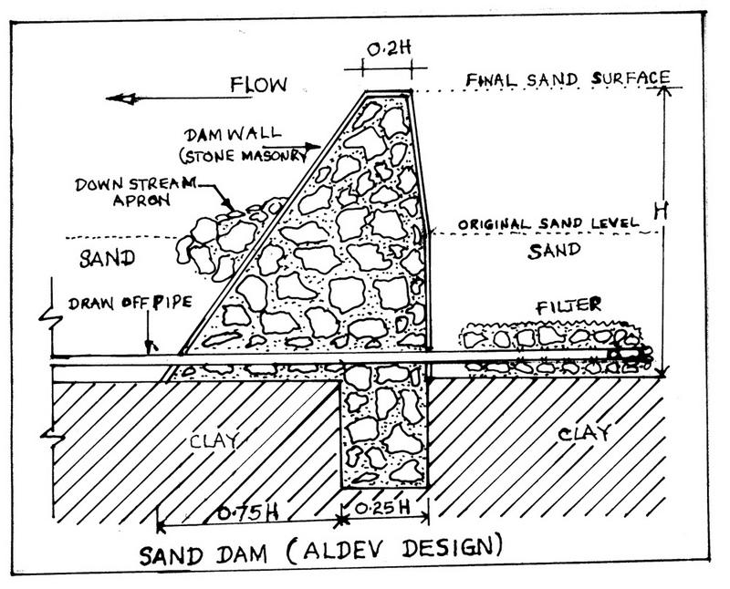
Technical specifications (related to technical drawing):
Technical knowledge required for field staff / advisors: high
Technical knowledge required for land users: moderate
Main technical functions: water harvesting / increase water supply, sediment retention / trapping, sediment harvesting
Secondary technical functions: increase / maintain water stored in soil
Construction material (concrete): Masonry structure using rocks & stones with some reinforcing bars and wires
Construction material (other): reinforced bars and wires
Lateral gradient along the structure: 5%
4.2 General information regarding the calculation of inputs and costs
other/ national currency (specify):
Kenya shillings
If relevant, indicate exchange rate from USD to local currency (e.g. 1 USD = 79.9 Brazilian Real): 1 USD =:
78.0
Indicate average wage cost of hired labour per day:
2.00
4.3 Establishment activities
| Activity | Timing (season) | |
|---|---|---|
| 1. | Digging out riverbed to reach rock bar | dryseason |
| 2. | Laying concrete foundation | dryseason |
| 3. | collection of materials (rocks, sand) | dryseason |
| 4. | construction of dam and wing walls | dryseason |
4.4 Costs and inputs needed for establishment
Comments:
Duration of establishment phase: 24 month(s)
4.5 Maintenance/ recurrent activities
| Activity | Timing/ frequency | |
|---|---|---|
| 1. | inspection of dam for leakages | after the rains/each cropping season |
4.6 Costs and inputs needed for maintenance/ recurrent activities (per year)
Comments:
depth of the foundation, valley width.
4.7 Most important factors affecting the costs
Describe the most determinate factors affecting the costs:
depth of foundation trench to the rock bar, the width of the river valley and the height of the banks.
5. Natural and human environment
5.1 Climate
Annual rainfall
- < 250 mm
- 251-500 mm
- 501-750 mm
- 751-1,000 mm
- 1,001-1,500 mm
- 1,501-2,000 mm
- 2,001-3,000 mm
- 3,001-4,000 mm
- > 4,000 mm
Agro-climatic zone
- sub-humid
- semi-arid
5.2 Topography
Slopes on average:
- flat (0-2%)
- gentle (3-5%)
- moderate (6-10%)
- rolling (11-15%)
- hilly (16-30%)
- steep (31-60%)
- very steep (>60%)
Landforms:
- plateau/plains
- ridges
- mountain slopes
- hill slopes
- footslopes
- valley floors
Altitudinal zone:
- 0-100 m a.s.l.
- 101-500 m a.s.l.
- 501-1,000 m a.s.l.
- 1,001-1,500 m a.s.l.
- 1,501-2,000 m a.s.l.
- 2,001-2,500 m a.s.l.
- 2,501-3,000 m a.s.l.
- 3,001-4,000 m a.s.l.
- > 4,000 m a.s.l.
Comments and further specifications on topography:
Slopes on average: Also gentle
Lanforms: In riverbeads
5.3 Soils
Soil depth on average:
- very shallow (0-20 cm)
- shallow (21-50 cm)
- moderately deep (51-80 cm)
- deep (81-120 cm)
- very deep (> 120 cm)
Soil texture (topsoil):
- coarse/ light (sandy)
- medium (loamy, silty)
Topsoil organic matter:
- low (<1%)
If available, attach full soil description or specify the available information, e.g. soil type, soil PH/ acidity, Cation Exchange Capacity, nitrogen, salinity etc.
Soil depth on average: Most areas have shallow soils with unweathered rocks.
Soil fertility is low
Soil drainage / infiltration is medium and soils are prone to surface sealing
Soil water storage capacity is low - medium
5.6 Characteristics of land users applying the Technology
Off-farm income:
- > 50% of all income
Relative level of wealth:
- poor
- average
Indicate other relevant characteristics of the land users:
Population density: 10-50 persons/km2
Annual population growth: 2% - 3%
1% of the land users are rich and own 5% of the land.
30% of the land users are average wealthy and own 35% of the land.
55% of the land users are poor and own 45% of the land.
14% of the land users are poor and own 15% of the land.
Off-farm income specification: A large proportion of the adult male population is working outside the district
5.8 Land ownership, land use rights, and water use rights
Land ownership:
- individual, not titled
- individual, titled
Land use rights:
- individual
6. Impacts and concluding statements
6.4 Cost-benefit analysis
How do the benefits compare with the establishment costs (from land users’ perspective)?
Short-term returns:
positive
Long-term returns:
positive
How do the benefits compare with the maintenance/ recurrent costs (from land users' perspective)?
Short-term returns:
very positive
Long-term returns:
very positive
6.5 Adoption of the Technology
- > 50%
If available, quantify (no. of households and/ or area covered):
23000 Households in an area of 200 sq km
Of all those who have adopted the Technology, how many did so spontaneously, i.e. without receiving any material incentives/ payments?
- 0-10%
Comments:
70% of land user families have adopted the Technology.
23000 land user families have adopted the Technology with external material support
Comments on acceptance with external material support: survey results
Comments on spontaneous adoption: estimates
There is a moderate trend towards spontaneous adoption of the Technology
Comments on adoption trend: self help groups have started pooling together their resources for implementation of the technology especially in areas where there has never been an NGO or such a project.
7. References and links
7.1 Methods/ sources of information
7.2 References to available publications
Title, author, year, ISBN:
"Where there is no water" SASOL and Maji na Ufanisi 1999
Available from where? Costs?
Maji na Ufanisi Nairobi or SASOL Kitui
Links and modules
Expand all Collapse allLinks
SASOL community approach - for sand dams in … [Kenya]
Community based water resource development
- Compiler: Donald B. Thomas
Modules
No modules