Semi-circle bunds [Syrian Arab Republic]
- Creation:
- Update:
- Compiler: kasem al ahmad
- Editor: –
- Reviewers: Fabian Ottiger, Alexandra Gavilano
Aquas Hajariya, Aquas Hilalia (Half moon) Arabic
technologies_1549 - Syrian Arab Republic
View sections
Expand all Collapse all1. General information
1.2 Contact details of resource persons and institutions involved in the assessment and documentation of the Technology
SLM specialist:
SLM specialist:
SLM specialist:
Iizumi Yoshiko
Japan international research center for agricultural science
Japan
Name of the institution(s) which facilitated the documentation/ evaluation of the Technology (if relevant)
International Center for Agricultural Research in the Dry Areas (ICARDA) - LebanonName of the institution(s) which facilitated the documentation/ evaluation of the Technology (if relevant)
Japan international research center for agricultural science (JIRCAS) - Japan1.3 Conditions regarding the use of data documented through WOCAT
The compiler and key resource person(s) accept the conditions regarding the use of data documented through WOCAT:
Yes
2. Description of the SLM Technology
2.1 Short description of the Technology
Definition of the Technology:
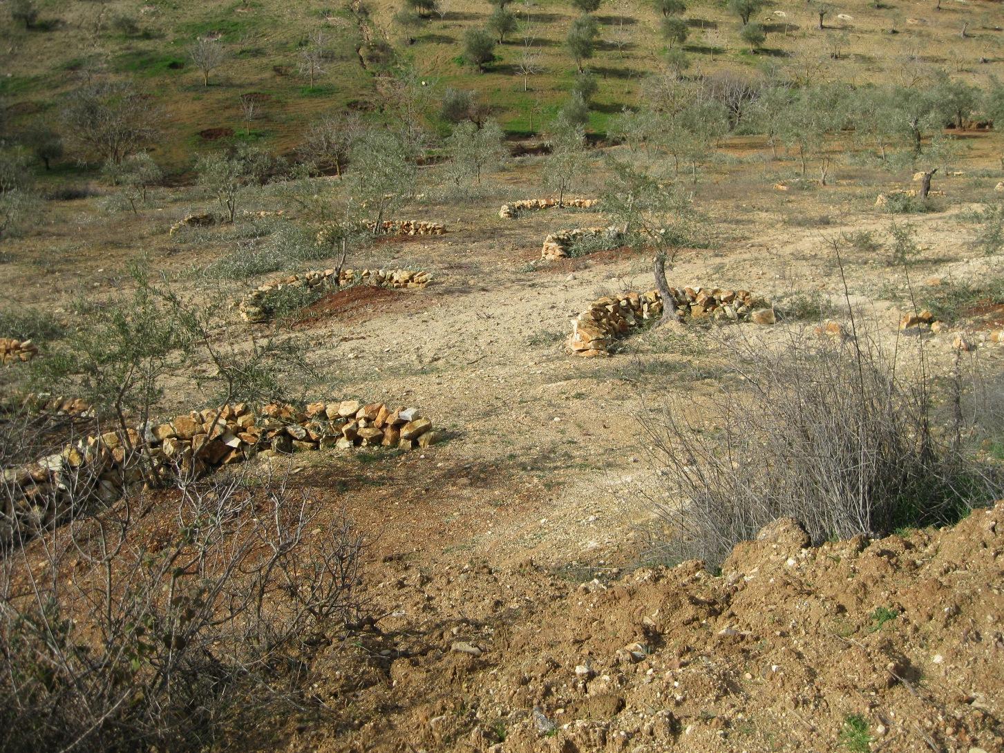
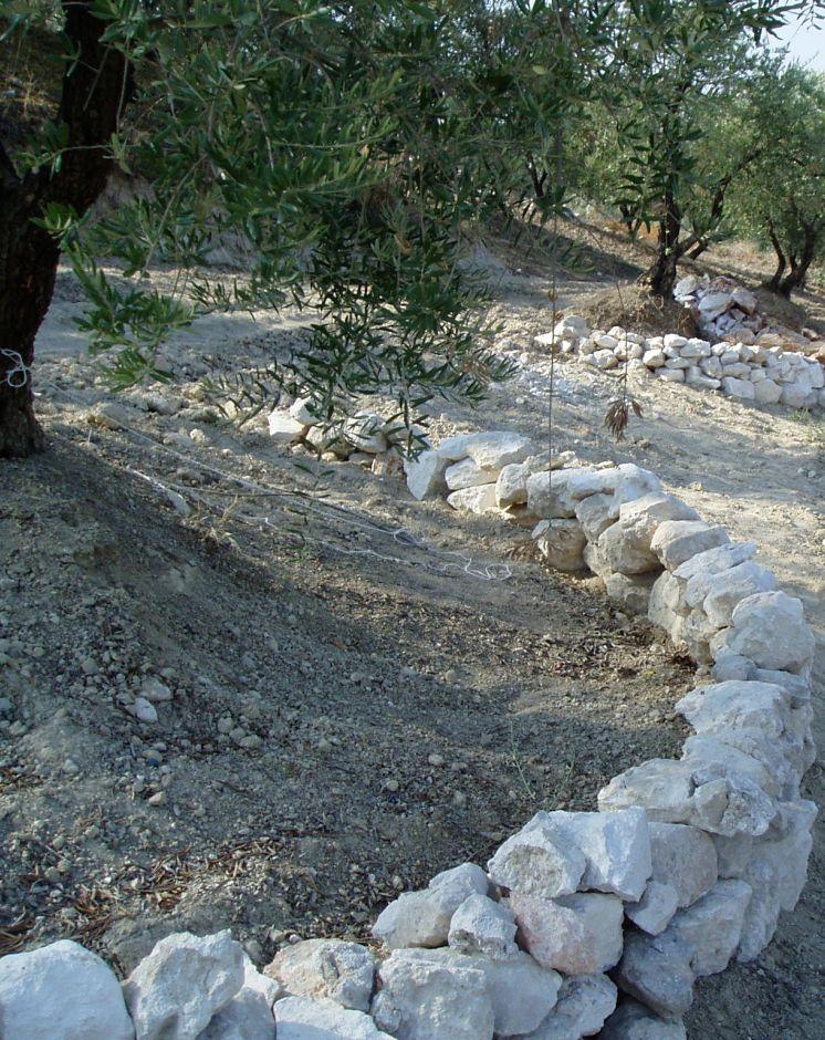
Semi-circle stone bunds are used as soil conservation and water harvesting structures to reduce soil erosion and improve productivity of olive trees.
2.2 Detailed description of the Technology
Description:
Semi-circle stone bunds are used as soil and water harvesting structures to improve productivity of trees, especially olive trees, on steep slopes. These are small-scale stone structures, with diameters between 3-5 m, established to catch rainfall and runoff from small micro-catchments covering relatively short slopes. This type of freestanding system (not contour system) is suitable for fields where trees are distributed in a staggered array. The slope steepness ranges from 15-40 degrees. Stones are mined from wasteland and transported to the slopes using tractors. Then the stones are set out in a semi circle (crescent) manually from a down side of the tree. The stone bunds are about 40 cm high with a base width of 30-40 cm. Most of the farmers add soil around the tree trunk and some of them add manure to improve the soil fertility. The technology makes the mechanized tillage difficult because of the layout of the structures. This reduces number of tillage operations and hence reduces erosion since tillage is one of the main causes of soil erosion under these conditions. The structures also reduce runoff velocity, which increases water availability for the plant roots (water harvesting) and also allows for more sedimentation around the trees and less transportation of soil particles and nutrients outside the field (soil conservation).
Purpose of the Technology: Semi-circle stone bunds are used to reduce losses of soil and nutrients and capture runoff water which helps to rehabilitate degraded land and improves the yield.
Establishment / maintenance activities and inputs: For one hectare of land with 100 bunds approximately 50 persons are needed to establish the bunds. The stones are set out in a semi-circle manually. A shovel is needed to prepare and level the stones bed. The costs are about $1950, which includes the price of the stones, transportation, equipment and labours. Then the bunds need maintenance every year, this will cost $54 per hectare. The perennial olive trees are mainly planted in January.
Natural / human environment: The area is dominated by steep slopes in a mountainous area in the north west of Syria. Small holdings are typical for this area with small plot sizes, narrow fields and shallow soil. Annual rainfall is between 400-600 mm. The technology was introduced to the community few years ago. Farmers were trained on how to layout, implement and maintain the structures by ICARDA and local extension services. Individual farmers are applying the technology on their own fields.
2.3 Photos of the Technology
Media Gallery
2.5 Country/ region/ locations where the Technology has been applied and which are covered by this assessment
Country:
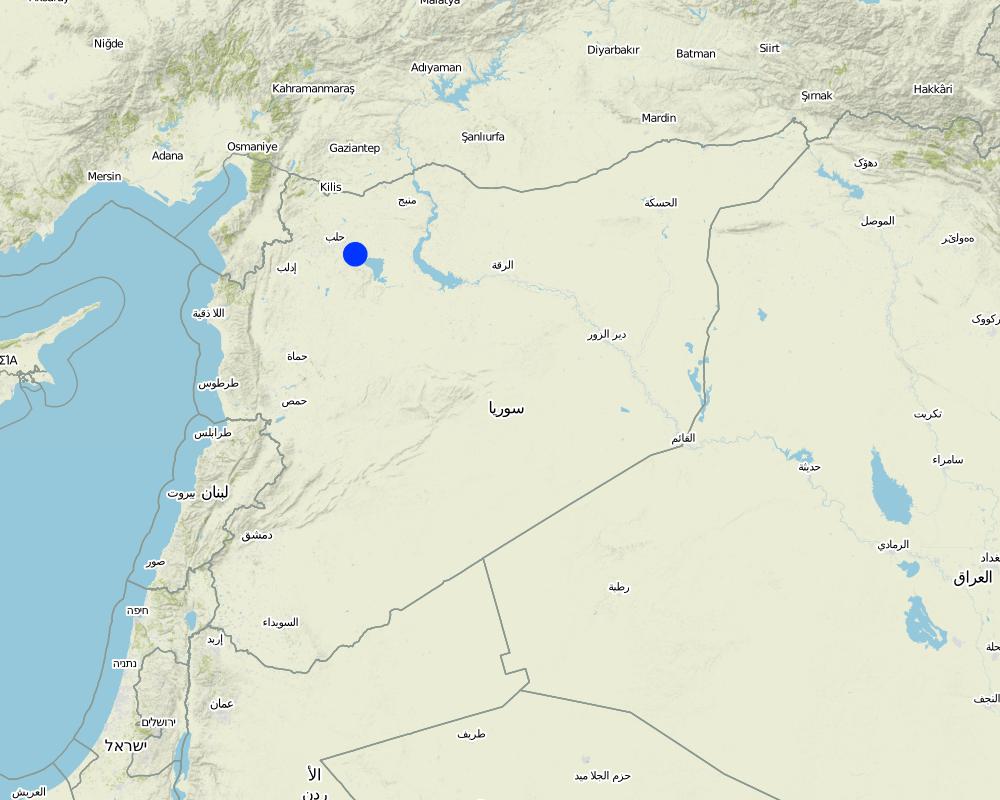
Syrian Arab Republic
Region/ State/ Province:
Aleppo, Idleb
Further specification of location:
Afrin (Maghara and Khaltan village) And Harem (Betya village)
Specify the spread of the Technology:
- evenly spread over an area
If precise area is not known, indicate approximate area covered:
- < 0.1 km2 (10 ha)
Comments:
Boundary points of the Technology area: Maghara(36.32.24.70),(36.39.21.84)
Khaltan(36.28.45),(36.42.30)
Bitya(36.07.57.38),(36.38.86.60)
Map
×2.6 Date of implementation
If precise year is not known, indicate approximate date:
- less than 10 years ago (recently)
2.7 Introduction of the Technology
Specify how the Technology was introduced:
- during experiments/ research
3. Classification of the SLM Technology
3.1 Main purpose(s) of the Technology
- improve production
- reduce, prevent, restore land degradation
- create beneficial economic impact
3.2 Current land use type(s) where the Technology is applied

Cropland
- Tree and shrub cropping
Tree and shrub cropping - Specify crops:
- olive
Number of growing seasons per year:
- 1

Grazing land
Extensive grazing:
- Ranching
- Livestock density (if relevant): 50-100 LU /km2
Comments:
Major land use problems (compiler’s opinion): soil erosion, low soil fertility and water shortage
Major land use problems (land users’ perception): decreasing productivity and high soil erosion
3.4 Water supply
Water supply for the land on which the Technology is applied:
- rainfed
3.5 SLM group to which the Technology belongs
- cross-slope measure
- water harvesting
- irrigation management (incl. water supply, drainage)
3.6 SLM measures comprising the Technology

structural measures
- S2: Bunds, banks
3.7 Main types of land degradation addressed by the Technology

soil erosion by water
- Wt: loss of topsoil/ surface erosion
- Wo: offsite degradation effects
Comments:
Main type of degradation addressed: Wt: loss of topsoil / surface erosion, Wo: offsite degradation effects
Main causes of degradation: soil management (Tillage equipment (tractor instead of mule), direction (with slope), number of operations per year), deforestation / removal of natural vegetation (incl. forest fires), Heavy / extreme rainfall (intensity/amounts), poverty / wealth (need cash money for conservation measures)
Secondary causes of degradation: change of seasonal rainfall, population pressure, inputs and infrastructure: (roads, markets, distribution of water points, other, …) (difficult to access target fields, no roads), governance / institutional (poor extension services)
3.8 Prevention, reduction, or restoration of land degradation
Specify the goal of the Technology with regard to land degradation:
- prevent land degradation
- reduce land degradation
Comments:
Main goals: mitigation / reduction of land degradation
Secondary goals: prevention of land degradation
4. Technical specifications, implementation activities, inputs, and costs
4.1 Technical drawing of the Technology
Technical specifications (related to technical drawing):
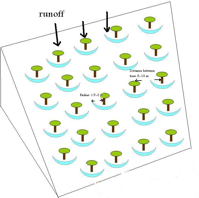
Semi circle technology within olive tree field.
Date: 28/12/2011
Technical knowledge required for field staff / advisors: high
Technical knowledge required for land users: moderate
Main technical functions: reduction of slope length, increase / maintain water stored in soil, water harvesting / increase water supply, sediment retention / trapping, sediment harvesting
Secondary technical functions: control of dispersed runoff: retain / trap, control of dispersed runoff: impede / retard, reduction of slope angle, increase in organic matter, increase in nutrient availability (supply, recycling,…), increase of infiltration
Bund/ bank: semi-circular/V shaped trapezoidal
Height of bunds/banks/others (m): 0.3-0.5
Width of bunds/banks/others (m): 0.3-0.4
Author:
ICARDA, P.O.Box 5466, Aleppo, Syria
4.2 General information regarding the calculation of inputs and costs
other/ national currency (specify):
Syrian pound (SYP)
If relevant, indicate exchange rate from USD to local currency (e.g. 1 USD = 79.9 Brazilian Real): 1 USD =:
50.0
4.3 Establishment activities
| Activity | Timing (season) | |
|---|---|---|
| 1. | Stone mining | Dry season |
| 2. | Distributing stones and building | Dry season |
| 3. | Equipment | Dry season |
4.4 Costs and inputs needed for establishment
| Specify input | Unit | Quantity | Costs per Unit | Total costs per input | % of costs borne by land users | |
|---|---|---|---|---|---|---|
| Labour | Distributing stones and building | ha | 1.0 | 753.0 | 753.0 | |
| Equipment | Machine use | ha | 1.0 | 184.0 | 184.0 | |
| Construction material | Stone | ha | 1.0 | 1029.0 | 1029.0 | |
| Total costs for establishment of the Technology | 1966.0 | |||||
| Total costs for establishment of the Technology in USD | 39.32 | |||||
Comments:
Duration of establishment phase: 1 month(s)
4.5 Maintenance/ recurrent activities
| Activity | Timing/ frequency | |
|---|---|---|
| 1. | Reforming the stone bunds | Dry season |
| 2. | Reforming the stone bunds | Dry season |
4.6 Costs and inputs needed for maintenance/ recurrent activities (per year)
| Specify input | Unit | Quantity | Costs per Unit | Total costs per input | % of costs borne by land users | |
|---|---|---|---|---|---|---|
| Labour | Reforming the stone bunds | ha | 1.0 | 54.0 | 54.0 | |
| Total costs for maintenance of the Technology | 54.0 | |||||
| Total costs for maintenance of the Technology in USD | 1.08 | |||||
Comments:
Machinery/ tools: The farmers pay the whole amount. However, farmers are using a special micro-credit system, where the farmers take the money as a loan and pay it back in two consecutive seasons.
The costs was calculated based on stones availability in the area and the distance from the target field, also the accessibility to the field can increase the cost because it need more labors for transfer and to distribute the stones on the field.
Number of trees: 100/ha,
Radius=1.5m–2 m,
length=4.71m–6.28 m,
height=5 cm–35 cm,
width=40cm–50cm
4.7 Most important factors affecting the costs
Describe the most determinate factors affecting the costs:
stone availability
field accessibility
5. Natural and human environment
5.1 Climate
Annual rainfall
- < 250 mm
- 251-500 mm
- 501-750 mm
- 751-1,000 mm
- 1,001-1,500 mm
- 1,501-2,000 mm
- 2,001-3,000 mm
- 3,001-4,000 mm
- > 4,000 mm
Specifications/ comments on rainfall:
400-650 dry season May-October (6 months)
Agro-climatic zone
- sub-humid
- semi-arid
Thermal climate class: subtropics
Thermal climate class: temperate
5.2 Topography
Slopes on average:
- flat (0-2%)
- gentle (3-5%)
- moderate (6-10%)
- rolling (11-15%)
- hilly (16-30%)
- steep (31-60%)
- very steep (>60%)
Landforms:
- plateau/plains
- ridges
- mountain slopes
- hill slopes
- footslopes
- valley floors
Altitudinal zone:
- 0-100 m a.s.l.
- 101-500 m a.s.l.
- 501-1,000 m a.s.l.
- 1,001-1,500 m a.s.l.
- 1,501-2,000 m a.s.l.
- 2,001-2,500 m a.s.l.
- 2,501-3,000 m a.s.l.
- 3,001-4,000 m a.s.l.
- > 4,000 m a.s.l.
5.3 Soils
Soil depth on average:
- very shallow (0-20 cm)
- shallow (21-50 cm)
- moderately deep (51-80 cm)
- deep (81-120 cm)
- very deep (> 120 cm)
Soil texture (topsoil):
- medium (loamy, silty)
- fine/ heavy (clay)
Topsoil organic matter:
- low (<1%)
If available, attach full soil description or specify the available information, e.g. soil type, soil PH/ acidity, Cation Exchange Capacity, nitrogen, salinity etc.
Soil fertility: Low
Soil drainage/infiltration: Medium (ranked 1) and poor (ranked 2)
Soil water storage capacity: High (ranked 1) and medium (ranked 2)
5.4 Water availability and quality
Availability of surface water:
good
Comments and further specifications on water quality and quantity:
Availability of surface water: Also medium (ranked 2)
5.6 Characteristics of land users applying the Technology
Market orientation of production system:
- subsistence (self-supply)
- mixed (subsistence/ commercial)
Off-farm income:
- 10-50% of all income
Relative level of wealth:
- poor
- average
Individuals or groups:
- individual/ household
Level of mechanization:
- animal traction
- mechanized/ motorized
Gender:
- men
Indicate other relevant characteristics of the land users:
Land users applying the Technology are mainly common / average land users
Annual population growth: negative
20% of the land users are average wealthy and own 40% of the land.
80% of the land users are poor and own 60% of the land.
Level of mechanization: Animal traction (mule tillage, ranked 1) and mechnaised (tractor tillage, ranked 2)
5.7 Average area of land used by land users applying the Technology
- < 0.5 ha
- 0.5-1 ha
- 1-2 ha
- 2-5 ha
- 5-15 ha
- 15-50 ha
- 50-100 ha
- 100-500 ha
- 500-1,000 ha
- 1,000-10,000 ha
- > 10,000 ha
Is this considered small-, medium- or large-scale (referring to local context)?
- small-scale
5.8 Land ownership, land use rights, and water use rights
Land ownership:
- individual, titled
Land use rights:
- individual
5.9 Access to services and infrastructure
health:
- poor
- moderate
- good
education:
- poor
- moderate
- good
technical assistance:
- poor
- moderate
- good
employment (e.g. off-farm):
- poor
- moderate
- good
markets:
- poor
- moderate
- good
energy:
- poor
- moderate
- good
roads and transport:
- poor
- moderate
- good
drinking water and sanitation:
- poor
- moderate
- good
financial services:
- poor
- moderate
- good
6. Impacts and concluding statements
6.1 On-site impacts the Technology has shown
Socio-economic impacts
Production
crop production
Water availability and quality
demand for irrigation water
Income and costs
expenses on agricultural inputs
Comments/ specify:
Tillage
farm income
diversity of income sources
workload
Comments/ specify:
Harvesting
Socio-cultural impacts
food security/ self-sufficiency
SLM/ land degradation knowledge
conflict mitigation
situation of socially and economically disadvantaged groups
Ecological impacts
Water cycle/ runoff
harvesting/ collection of water
surface runoff
Soil
soil moisture
soil loss
nutrient cycling/ recharge
soil organic matter/ below ground C
Biodiversity: vegetation, animals
biomass/ above ground C
6.2 Off-site impacts the Technology has shown
reliable and stable stream flows in dry season
downstream flooding
groundwater/ river pollution
damage on neighbours' fields
6.3 Exposure and sensitivity of the Technology to gradual climate change and climate-related extremes/ disasters (as perceived by land users)
Gradual climate change
Gradual climate change
| Season | increase or decrease | How does the Technology cope with it? | |
|---|---|---|---|
| annual temperature | increase | well |
Climate-related extremes (disasters)
Meteorological disasters
| How does the Technology cope with it? | |
|---|---|
| local rainstorm | not well |
| local windstorm | well |
Climatological disasters
| How does the Technology cope with it? | |
|---|---|
| drought | well |
Hydrological disasters
| How does the Technology cope with it? | |
|---|---|
| general (river) flood | not well |
Other climate-related consequences
Other climate-related consequences
| How does the Technology cope with it? | |
|---|---|
| reduced growing period | not known |
6.4 Cost-benefit analysis
How do the benefits compare with the establishment costs (from land users’ perspective)?
Short-term returns:
slightly negative
Long-term returns:
slightly positive
How do the benefits compare with the maintenance/ recurrent costs (from land users' perspective)?
Short-term returns:
slightly negative
Long-term returns:
positive
6.5 Adoption of the Technology
If available, quantify (no. of households and/ or area covered):
52
Comments:
50 land user families have adopted the Technology with external material support
Comments on acceptance with external material support: Farmers get loans through micro-credit system and not as payment
2 land user families have adopted the Technology without any external material support
There is a little trend towards spontaneous adoption of the Technology
6.7 Strengths/ advantages/ opportunities of the Technology
| Strengths/ advantages/ opportunities in the land user’s view |
|---|
| Reducing soil erosion |
| Iincreasing soil moisture |
| Increasing yield |
| Strengths/ advantages/ opportunities in the compiler’s or other key resource person’s view |
|---|
|
Reducing soil erosion How can they be sustained / enhanced? Starting implementation at fields located at top of mountains and then down the slopes (need cooperation among farmers) |
|
Increasing soil depth and moisture around the tree How can they be sustained / enhanced? Provide enabling environment (such as micro credit system, proper extension and technical back stopping) |
6.8 Weaknesses/ disadvantages/ risks of the Technology and ways of overcoming them
| Weaknesses/ disadvantages/ risks in the land user’s view | How can they be overcome? |
|---|---|
| High cost (stone mining) | |
| High knowledge (extension service, training, guidance) | |
| Retard traditional tillage operation and harvesting |
| Weaknesses/ disadvantages/ risks in the compiler’s or other key resource person’s view | How can they be overcome? |
|---|---|
| High cost (stone mining) | consider the long-term benefit, it is feasible |
| Look for closer/ cheaper source of stones |
7. References and links
7.1 Methods/ sources of information
7.2 References to available publications
Title, author, year, ISBN:
Brochure, ICARDA, 2011
Title, author, year, ISBN:
Movie, ICARDA, 2011
7.3 Links to relevant online information
Title/ description:
Poster
URL:
http://meetingorganizer.copernicus.org/EGU2010/poster_programme/2499 file number EGU2010-9237
Links and modules
Expand all Collapse allLinks
No links
Modules
No modules