Technologies

Hand-dug trenches [Niger]

Tranchées manuelles (French)

technologies_1625 - Niger

Completeness: 78%

1. General information

1.2 Contact details of resource persons and institutions involved in the assessment and documentation of the Technology

Key resource person(s)

SLM specialist:
{'additional_translations': {}, 'value': 'Dieter Nill', 'user_id': '2699', 'unknown_user': False, 'template': 'raw'}
SLM specialist:

Dorlöchter-Sulser Sabine

Misereor

Germany

SLM specialist:

Mamadou Abdou Gaoh Sani

Programme d’Appui à l’agriculture Productive (PROMAP)

Niger

{'additional_translations': {}, 'value': 1004, 'label': 'Name of project which facilitated the documentation/ evaluation of the Technology (if relevant)', 'text': 'Programme d’Appui à l’agriculture Productive (GIZ / PROMAP)', 'template': 'raw'} {'additional_translations': {}, 'value': 1145, 'label': 'Name of the institution(s) which facilitated the documentation/ evaluation of the Technology (if relevant)', 'text': 'Misereor - Germany', 'template': 'raw'} {'additional_translations': {}, 'value': 1145, 'label': 'Name of the institution(s) which facilitated the documentation/ evaluation of the Technology (if relevant)', 'text': 'Misereor - Germany', 'template': 'raw'}

1.3 Conditions regarding the use of data documented through WOCAT

The compiler and key resource person(s) accept the conditions regarding the use of data documented through WOCAT:

Yes

2. Description of the SLM Technology

2.1 Short description of the Technology

Definition of the Technology:

Hand-dug trenches contribute to the restoration of tree cover and prevention of water erosion on slopes.

2.2 Detailed description of the Technology
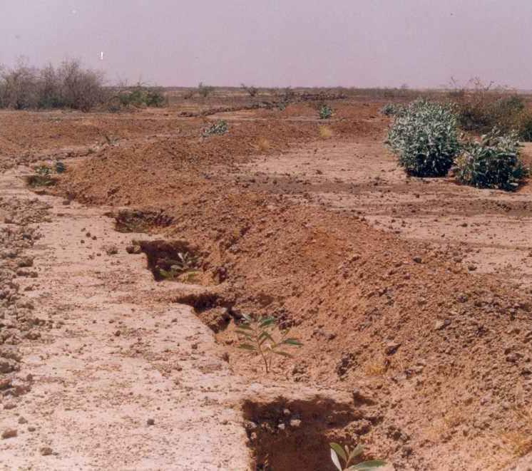
Description:

This technique is designed to restore communal land on slopes and highland pediments. It involves manually excavating trenches 3 to 3.5 m long and 0.6 m deep, spaced 4 m apart in staggered rows. This results in around 625 trenches per hectare. The excavated earth is piled downhill of the trenches, which are aligned perpendicular to the slope. In the middle of each trench, a 0.40 m high step is left on which the tree seedling is planted. The tree receives the water it needs from the trench where it collects.

Purpose of the Technology: The main purpose of this technique is to restore tree cover on degraded, unfertile land and prevent water erosion on slopes by reducing the flow of water that threatens land downstream. The trenches reduce gully erosion and pedimentation of areas with a fragile soil structure. Like all afforestation measures, in the medium term, this technique is effective in protecting the land against water and wind erosion. The shade provided by the trees also lowers the temperature of the soil and the infiltration of water in the hand-dug trenches contributes to groundwater recharge.
Areas restored using hand-dug trenches can subsequently be exploited to a limited extent in accordance with strict controls.

Establishment / maintenance activities and inputs: The technique is very labour intensive. Work must begin immediately after harvesting when the soil is still moist and workable. A protection and monitoring system is required to ensure that grazing animals do not damage the young trees. The mortality of trees after planting is relatively high (survival rate is about 60%), and dead trees must be replaced systematically during the first three years. Good community organisation is required.

Natural / human environment: Hand-dug trenches are particularly useful when rainfall is low, as they retain water and make it available to the trees growing in them. In years when rainfall is abundant or there are violent downpours, the young trees are protected, as they are planted on a raised step within the trench, although there is a risk of flooding in the event of very heavy rain.

2.3 Photos of the Technology

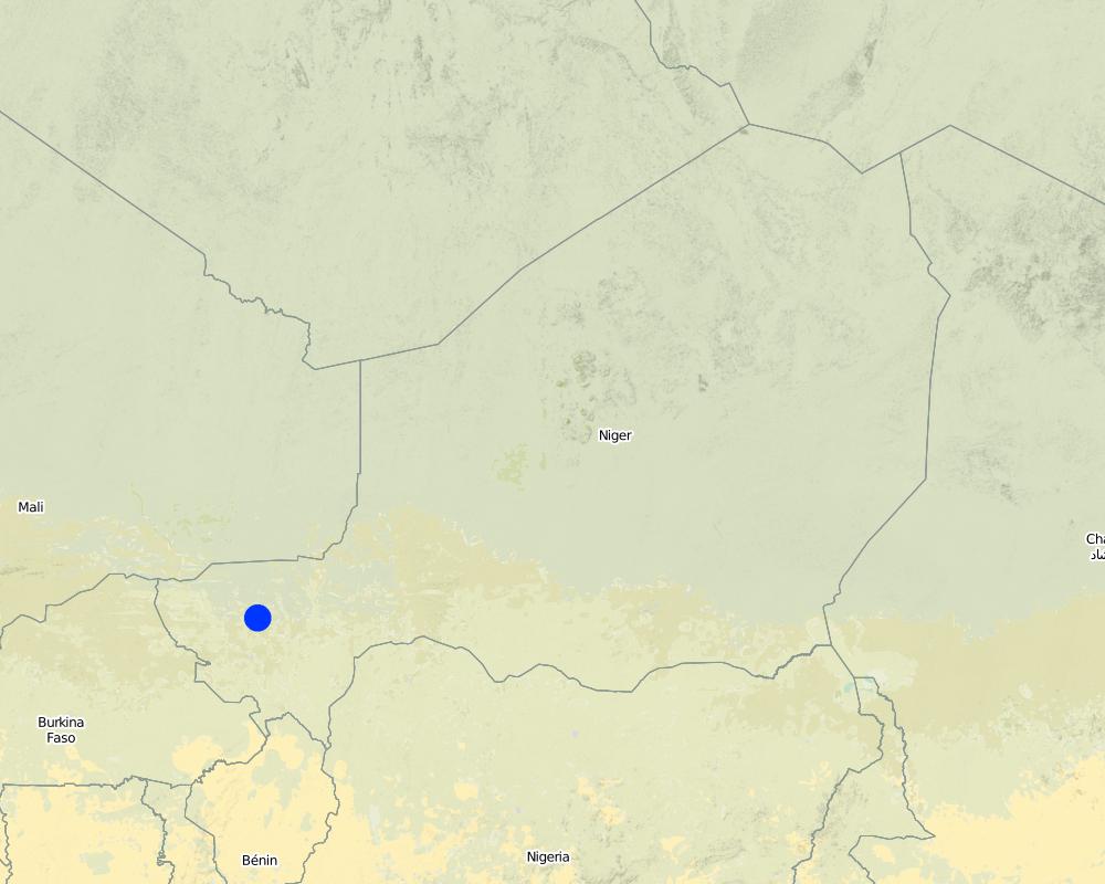
2.5 Country/ region/ locations where the Technology has been applied and which are covered by this assessment

Country:

Niger

Region/ State/ Province:

Niger

Further specification of location:

Regions of Tillabéri, Filingué, Ouallam, Téra and Tahuoa

Specify the spread of the Technology:
  • evenly spread over an area
{'is_geometry': True, 'configuration': 'technologies', 'additional_translations': {}, 'key': 'Map', 'value': '{"type":"FeatureCollection","features":[{"type":"Feature","id":1493455493069,"geometry":{"type":"Point","coordinates":[2.216495,14.251922000000008]},"properties":null}]}', 'questionnaire_object': <Questionnaire: {"qg_name": [{"name": {"en": "Hand-dug trenches", "fr": "Tranch\u00e9es manuelles"}, "name_local": {"en": "Tranch\u00e9es manuelles (French)", "fr": "Tranch\u00e9es manuelles (French)"}}], "qg_links": [{"links_url": {"en": "http://agriwaterpedia.info/wiki/Main_Page", "fr": "http://agriwaterpedia.info/wiki/Main_Page"}, "links_title": {"en": "Good Practices in Soil and Water Conservation. A contribution to adaptation and farmers\u00b4 resilience towards climate change in the Sahel. Published by GIZ in 2012.", "fr": "Good Practices in Soil and Water Conservation. A contribution to adaptation and farmers\u00b4 resilience towards climate change in the Sahel. Published by GIZ in 2012."}}], "qg_photos": [{"image": "8f5698b0-87e2-4010-aa53-df902e8c2cd8", "image_caption": {"en": "Row of hand-dug trenches", "fr": "Bande de tranch\u00e9es manuelles "}, "image_photographer": {"en": "GIZ, PASP", "fr": "GIZ, PASP"}}, {"image": "40ed8dfe-f762-4ac5-9e76-8a421effb39e", "image_caption": {"en": "Revegetated slope", "fr": "Versaant rev\u00e9g\u00e9talis\u00e9 "}, "image_location": {"en": "Tahoua, Niger", "fr": "Tahoua, Niger"}, "image_photographer": {"en": "Dieter Nill", "fr": "Dieter Nill"}}], "tech_qg_1": [{"tech_definition": {"en": "Hand-dug trenches contribute to the restoration of tree cover and prevention of water erosion on slopes.", "fr": "L\u2019objectif principal est de r\u00e9habiliter la v\u00e9g\u00e9tation ligneuse et de lutter contre l\u2019\u00e9rosion hydrique sur les pentes en diminuant le ruissellement des eaux mena\u00e7ant les terres en aval"}}], "tech_qg_2": [{"tech_description": {"en": "This technique is designed to restore communal land on slopes and highland pediments. It involves manually excavating trenches 3 to 3.5 m long and 0.6 m deep, spaced 4 m apart in staggered rows. This results in around 625 trenches per hectare. The excavated earth is piled downhill of the trenches, which are aligned perpendicular to the slope. In the middle of each trench, a 0.40 m high step is left on which the tree seedling is planted. The tree receives the water it needs from the trench where it collects.\r\n\r\nPurpose of the Technology: The main purpose of this technique is to restore tree cover on degraded, unfertile land and prevent water erosion on slopes by reducing the flow of water that threatens land downstream. The trenches reduce gully erosion and pedimentation of areas with a fragile soil structure. Like all afforestation measures, in the medium term, this technique is effective in protecting the land against water and wind erosion. The shade provided by the trees also lowers the temperature of the soil and the infiltration of water in the hand-dug trenches contributes to groundwater recharge.\r\nAreas restored using hand-dug trenches can subsequently be exploited to a limited extent in accordance with strict controls.\r\n\r\nEstablishment / maintenance activities and inputs: The technique is very labour intensive. Work must begin immediately after harvesting when the soil is still moist and workable. A protection and monitoring system is required to ensure that grazing animals do not damage the young trees. The mortality of trees after planting is relatively high (survival rate is about 60%), and dead trees must be replaced systematically during the first three years. Good community organisation is required.\r\n\r\nNatural / human environment: Hand-dug trenches are particularly useful when rainfall is low, as they retain water and make it available to the trees growing in them. In years when rainfall is abundant or there are violent downpours, the young trees are protected, as they are planted on a raised step within the trench, although there is a risk of flooding in the event of very heavy rain.", "fr": "Cette technique a \u00e9t\u00e9 con\u00e7ue en vue de la r\u00e9cup\u00e9ration de terres communautaires d\u00e9grad\u00e9es se trouvant sur des pentes et des hauts glacis. Il s\u2019agit de tranch\u00e9es creus\u00e9es manuellement de 3 \u00e0 3,50 m de longueur et de 0,60 m de profondeur. Les tranch\u00e9es sont excav\u00e9es \u00e0 un intervalle de 4 m en quinconce avec au total environ 625 unit\u00e9s par ha. La terre excav\u00e9e est d\u00e9pos\u00e9e en aval des tranch\u00e9es implant\u00e9es perpendiculairement \u00e0 la pente. Au milieu de chaque tranch\u00e9e, il y a un socle de 0,40 m sur lequel est plant\u00e9 un arbre qui est aliment\u00e9 en eau collect\u00e9e dans la tranch\u00e9e.\r\n\r\nPurpose of the Technology: L\u2019objectif principal est de r\u00e9habiliter la v\u00e9g\u00e9tation ligneuse et de lutter contre l\u2019\u00e9rosion hydrique sur les pentes en diminuant le ruissellement des eaux mena\u00e7ant les terres en aval. Les tranch\u00e9es ralentissent la formation de ravines et la glacification des terres fragiles. \r\nComme toute mesure de reboisement, cette technique a un effet protecteur contre l\u2019\u00e9rosion hydrique et \u00e9olienne \u00e0 moyen terme. L\u2019ombrage form\u00e9 par les arbres contribue aussi \u00e0 baisser la temp\u00e9rature au sol.\r\nLes superficies am\u00e9nag\u00e9es peuvent \u00eatre exploit\u00e9es \u00e0 intensit\u00e9 degr\u00e9 limit\u00e9e et selon une r\u00e8glementation stricte.\r\n\r\nEstablishment / maintenance activities and inputs: La technique est tr\u00e8s intensive en main d\u2019\u0153uvre. Les travaux doivent d\u00e9marrer directement apr\u00e8s les r\u00e9coltes pour profiter de la terre molle et encore humide. Pour ne pas compromettre la croissance des arbres, il faut un syst\u00e8me de mise en d\u00e9fens et de surveillance contre la divagation des animaux. La mortalit\u00e9 des arbres apr\u00e8s la plantation est assez \u00e9lev\u00e9e (taux de survie d\u2019environ 60 %) et exige un regarni syst\u00e9matique les trois premi\u00e8res ann\u00e9es. Il y a besoin d'une bonne organisation communautaire.\r\n\r\nNatural / human environment: Les tranch\u00e9es manuelles sont particuli\u00e8rement int\u00e9ressantes dans une p\u00e9riode \u00e0 faible pluviom\u00e9trie en raison de sa capacit\u00e9 de retenir l\u2019eau et de la mettre \u00e0 la disposition des plants. Dans les ann\u00e9es de pluies abondantes ou de pluies fortes ou violentes, les jeunes arbres sont prot\u00e9g\u00e9s par le socle sur\u00e9lev\u00e9 \u00e0 l\u2019int\u00e9rieur de la tranch\u00e9e. Il existe n\u00e9anmoins un certain risque d\u2019inondation en cas de tr\u00e8s fortes averses."}}], "tech_qg_4": [{"tech_spread_tech": "tech_spread_evenly"}], "tech_qg_5": [{"tech_who_implemented": ["implementation_externally"], "tech_who_implemented_comments": {"en": "Developed, implemented and disseminated as part of projects and programmes undertaken from the 1980s onwards to combat desertification and improve natural resource management. Implemented by German Development Cooperation (BMZ, GIZ, KfW) in Niger by projects e.g. PDRT (Projet de d\u00e9veloppement rural de Tahoua - Tahoua Rural Development Project)", "fr": "La technologie a \u00e9t\u00e9 developp\u00e9e et dissemin\u00e9e par des projets de lute contre la desertification et de gestion des ressources naturelles \u00e0 partir de 1980. La Cooperation Allemande (BMZ, GIZ, KfW) a utilise les tranch\u00e9es au Niger dans le PDRT (Projet de d\u00e9veloppement rural de Tahoua)"}}], "tech_qg_6": [{"tech_main_purpose": ["main_purpose_degradation"]}], "tech_qg_7": [{"tech_lu_comments": {"en": "major cash crop: Ground nut\r\nmajor food crop: Millet\r\nother: Sorghum, cow peas and mangoes\r\n\r\nMajor land use problems (compiler\u2019s opinion): water erosion (gully, sheet), wind erosion, degraded and infertile land\r\n\r\nNomadism: Yes\r\n\r\nSemi-nomadism / pastoralism: Yes\r\n\r\nCut-and-carry/ zero grazing: Yes\r\n\r\nImproved pasture: Yes\r\n\r\nMixed: (eg agro-pastoralism, silvo-pastoralism): Yes\r\n\r\nOther grazingland: agropastoralism\r\n\r\nSelective felling of (semi-) natural forests: Yes\r\n\r\nForest products and services: timber, fuelwood, fruits and nuts, grazing / browsing, other forest products / uses (honey, medical, etc.)\r\n\r\nType of cropping system and major crops comments: armers are mainly agropastoralists with some communities specialised on pure pastoralism\r\n\r\nConstraints of common grazing land\r\n\r\nConstraints of forested government-owned land or commons\r\n\r\nLivestock density: 1-10 LU /km2", "fr": "R\u00e9colte commerciale majeure: Noix de terre\r\nPrincipale culture alimentaire: Millet\r\nother: Sorghum, cow peas and mangoes\r\n\r\nPrincipaux probl\u00e8mes d'utilisation des sols (opinion du compilateur): \u00e9rosion hydrique et \u00e9olienne, terres d\u00e9grad\u00e9es et non fertiles\r\n\r\nContraintes de p\u00e2turages commune\r\n\r\nContraintes des terres bois\u00e9es (gouvernement) ou communes\r\n\r\nDensit\u00e9 d'\u00e9levage/ chargement: 1-10 LU /km2"}}], "tech_qg_8": [{"tech_measures": ["tech_measures_vegetative", "tech_measures_structural"]}], "tech_qg_9": [{"tech_landuse_2018": ["tech_lu_cropland", "tech_lu_grazingland", "tech_lu_forest"]}], "tech_qg_10": [{"tech_growing_seasons": "growing_season_1", "tech_lu_cropland_sub": ["lu_cropland_ca", "lu_cropland_ct"], "tech_growing_seasons_specify": {"en": "Longest growing period in days: 120; Longest growing period from month to month: August to October", "fr": "La plus longue p\u00e9riode de croissance en jours: 120; P\u00e9riode de croissance la plus longue de mois en mois: Ao\u00fbt-Octobre"}, "tech_lu_cropland_annual_cropping_crops": ["annual_crops_456", "annual_crops_430", "annual_crops_439", "annual_crops_434"], "tech_lu_cropland_tree_shrub_cropping_crops": ["tree_shrub_509"]}], "tech_qg_11": [{"tech_lu_grazingland_extensive": ["tech_lu_grazingland_nomadism", "tech_lu_grazingland_pastoralism"], "tech_lu_grazingland_intensive": ["tech_lu_grazingland_zerograzing", "tech_lu_grazingland_improvedpasture"]}], "tech_qg_12": [{"tech_lu_forest_type": ["lu_forest_natural"], "tech_lu_forest_natural": ["lu_forest_selectivefelling"], "tech_lu_forest_products": ["tech_lu_forestproducts_timber", "tech_lu_forestproducts_fuelwood", "tech_lu_forestproducts_fruitsnuts", "tech_lu_forestproducts_otherproducts", "tech_lu_forestproducts_grazing"]}], "tech_qg_19": [{"tech_watersupply": "tech_watersupply_rainfed", "tech_watersupply_comments": {"en": "Water supply: Also mixed rainfed - irrigated and post-flooding", "fr": "Approvisionnement en eau: \u00c9galement mixte pluviale - irrigu\u00e9 et post-inondation"}}], "tech_qg_20": [{"tech_slm_group": ["tech_slm_group_groundcover", "tech_slm_group_irrigation"]}], "tech_qg_22": [{"tech_measures_vegetative_sub": ["measures_vegetative_v1"]}], "tech_qg_23": [{"tech_measures_structural_sub": ["measures_structural_s3"]}], "tech_qg_27": [{"tech_degradation": ["degradation_erosion_water", "degradation_erosion_wind", "degradation_chemical", "degradation_biological", "degradation_water"]}], "tech_qg_28": [{"degradation_erosion_water_sub": ["degradation_wt", "degradation_wg", "degradation_wo"]}], "tech_qg_29": [{"degradation_erosion_wind_sub": ["degradation_et"]}], "tech_qg_30": [{"degradation_chemical_sub": ["degradation_cn"]}], "tech_qg_32": [{"degradation_biological_sub": ["degradation_bc"]}], "tech_qg_33": [{"degradation_water_sub": ["degradation_ha", "degradation_hg"]}], "tech_qg_34": [{"degradation_comments": {"en": "Secondary types of degradation addressed: Et: loss of topsoil, Hg: change in groundwater / aquifer level\r\n\r\nMain causes of degradation: soil management (Unadapted land use methods, reduced or abandoned fallow periods), crop management (annual, perennial, tree/shrub) (Neglect of fallow periods and crop rotation), droughts (due to heat waves), population pressure (rapidly growing population increasing pressure on land), land tenure (insecure access to land and collectively managed communal land), poverty / wealth (very poor population)\r\n\r\nSecondary causes of degradation: deforestation / removal of natural vegetation (incl. forest fires) (deforestation through overgrazing and fire wood collection), over-exploitation of vegetation for domestic use (firewood collection), overgrazing (cattle, sheep and goats), change in temperature (Climate change: heat waves), change of seasonal rainfall (more variable onset of rains), Heavy / extreme rainfall (intensity/amounts) (more variable and intensive rains), wind storms / dust storms (frequent storms), floods (due to intensive rain storms), labour availability (some migration of men to nearby cities), education, access to knowledge and support services (high level of illiteracy)", "fr": "Types de d\u00e9gradation secondaires abord\u00e9s: Et: perte du sol de surface, Hg: modification dans les nappes phr\u00e9atiques et aquif\u00e8res\r\n\r\nPrincipales causes de d\u00e9gradation: s\u00e9cheresses (\u00e0 cause de vagues de chaleurs et pluviom\u00e9trie d\u00e9ficientes), pression de la population (pression d\u00e9mographique, augmentation de la pression sur les terres), r\u00e9gime foncier, pauvret\u00e9 / Sant\u00e9 (population pauvre)\r\n\r\nCauses secondaires de la d\u00e9gradation: d\u00e9forestation / disparition de la v\u00e9g\u00e9tation naturelle (notamment les feux de for\u00eats), la surexploitation de la v\u00e9g\u00e9tation pour l'usage domestique, Surp\u00e2turage (boeufs, ch\u00e8vres, moutons), changement de temp\u00e9rature (changement climatique, vagues de chaleur), changement des pr\u00e9visions saisonni\u00e8res (d\u00e9marrage des pluies plus variable), fort / extr\u00eame niveau de pr\u00e9cipitation (intensit\u00e9 et quantit\u00e9) (pluies plus variables et intenses ), Temp\u00eates de vent / de poussi\u00e8re (temp\u00eates fr\u00e9quentes), \u00e9ducation, acc\u00e8s \u00e0 la connaissance et aux conseils (taux \u00e9lev\u00e9 d'analphab\u00e9tisme)"}}], "tech_qg_35": [{"tech_prevention": ["intervention_rehabilitate"], "tech_prevention_comments": {"en": "Secondary goals: prevention of land degradation, mitigation / reduction of land degradation", "fr": "Objectifs secondaires: pr\u00e9vention de la d\u00e9gradation des terres, att\u00e9nuation / r\u00e9duction de la d\u00e9gradation des sols"}}], "tech_qg_36": [{"tech_input_est_unit": {"en": "unit", "fr": "unit\u00e9"}, "tech_input_est_costs": 220.76, "tech_input_est_specify": {"en": "All the Labour", "fr": "Tout le travail"}, "tech_input_est_quantity": 1.0, "tech_input_est_total_costs_pi": 220.76}], "tech_qg_38": [{"tech_input_est_unit": {"en": "unit", "fr": "unit\u00e9"}, "tech_input_est_costs": 41.55, "tech_input_est_specify": {"en": "Seedlings", "fr": "Semis"}, "tech_input_est_quantity": 1.0, "tech_input_est_total_costs_pi": 41.55}], "tech_qg_40": [{"tech_input_est_unit": {"en": "unit", "fr": "unit\u00e9"}, "tech_input_est_costs": 1.93, "tech_input_est_specify": {"en": "Transport of seedlings", "fr": "Transport de semis"}, "tech_input_est_quantity": 1.0, "tech_input_est_total_costs_pi": 1.93}], "tech_qg_43": [{"tech_maint_activity": {"en": "A protection and monitoring system is required to ensure that grazing animals do not damage the young trees", "fr": "Pour ne pas compromettre la croissance des arbres, il faut un syst\u00e8me de mise en d\u00e9fens et de surveillance contre la divagation des animaux"}}, {"tech_maint_activity": {"en": "dead trees must be replaced systematically during the first three years", "fr": "La mortalit\u00e9 des arbres apr\u00e8s la plantationest assez \u00e9lev\u00e9e (taux de survie d\u2019environ 60 %) et exige un regarni syst\u00e9matique les trois premi\u00e8res ann\u00e9es"}}], "tech_qg_54": [{"tech_rainfall": ["tech_rainfall_501_750"]}], "tech_qg_55": [{"tech_agroclimatic_zone": ["tech_agroclimatic_zone_semiarid"], "tech_agroclimatic_zone_specifications": {"en": "Thermal climate class: subtropics", "fr": "Classe de climat thermique: subtropics"}}], "tech_qg_56": [{"tech_slopes": ["tech_slopes_gentle", "tech_slopes_moderate"], "tech_landforms": ["tech_landforms_plateau", "tech_landforms_hillslopes"], "tech_altitudinalzone": ["tech_altitudinalzone_100_500", "tech_altitudinalzone_500_1000"]}], "tech_qg_57": [{"tech_topography_comments": {"en": "Altitudinal zone: 200 m a.s.l.\r\n\r\nLandforms: Also footslopes and valley floors", "fr": "Pentes en moyenne: Aussi onduleux (11-15%)\r\n\r\nZone altitudinale: Aussi 1000-1500 m a.s.l. et 1500-2000 m a.s.l."}}], "tech_qg_58": [{"tech_soil_depth": ["tech_soil_depth_veryshallow", "tech_soil_depth_shallow"], "tech_topsoil_organic": ["tech_topsoil_organic_low"], "tech_soil_texture_topsoil": ["tech_soil_texture_medium", "tech_soil_texture_fine"]}], "tech_qg_59": [{"tech_soil_comments": {"en": "Soil fertility is very low - medium\r\n\r\nSoil drainage / infiltration is poor - medium\r\n\r\nSoil water storage capacity is low - medium", "fr": "La fertilit\u00e9 du sol est tr\u00e8s faible - moyenne\r\n\r\nLe drainage des sols / l'infiltration est m\u00e9diocre - moyen\r\n\r\nLa capacit\u00e9 de stockage d'eau du sol est faible - moyenne"}}], "tech_qg_60": [{"tech_groundwater": "tech_groundwater_5_50m", "tech_surfacewater": "tech_surfacewater_medium", "tech_waterquality": "tech_waterquality_agriculturaluse"}], "tech_qg_65": [{"tech_water_comments": {"en": "Ground water table: > 10m\r\n\r\nAvailability of surface water: Surface runoff generated by limited but intense rainfalls", "fr": "Profondeur estim\u00e9e de l\u2019eau dans le sol: > 10 m\r\n\r\nDisponibilit\u00e9 des eaux de surface: \u00e9coulement de surface g\u00e9n\u00e9r\u00e9 par des pluies limit\u00e9es mais intenses"}}], "tech_qg_66": [{"tech_speciesdiversity": "measure_low"}], "tech_qg_71": [{"tech_gender": ["gender_men"], "tech_wealth": ["tech_wealth_verypoor", "tech_wealth_poor"], "tech_mechanisation": ["mechanisation_manual", "mechanisation_animal"], "tech_offfarm_income": ["offfarm_income_10_50"], "tech_market_orientation": ["tech_market_orientation_subsistence", "tech_market_orientation_mixed"]}], "tech_qg_72": [{"tech_land_size": ["tech_land_size_2_5", "tech_land_size_5_15"], "tech_land_comments": {"en": "Average area of land owned or leased by land users applying the Technology: Also 1-2 ha", "fr": "Aussi 1-2 ha"}, "tech_land_size_relative": ["tech_size_smallscale"]}], "tech_qg_73": [{"tech_ownership": ["tech_ownership_state", "tech_ownership_communal"], "tech_landuserights": ["tech_userights_individual"], "tech_ownership_other": {"en": "not titled"}}], "tech_qg_75": [{"tech_ownership_comments": {"en": "Traditional land use rights prevail. On fields individual land use rights, communal rights on pasture and forest land (collection of wood and other products (fruits, medicinal plants))", "fr": "Droits traditionnels d'utilisation des terres, terres communales sur les p\u00e2turages et les terres foresti\u00e8res (collecte du bois et d'autres produits (fruits, plantes m\u00e9dicinales))\r\n\r\nPropri\u00e9t\u00e9 fonci\u00e8re: Aussi individu, sans titre de propri\u00e9t\u00e9 "}}], "tech_qg_77": [{"tech_landuser_comments": {"en": "Population density: 10-50 persons/km2\r\n\r\nAnnual population growth: 3% - 4%\r\n\r\n (mostly poor households below poverty line).\r\n\r\nOff-farm income specification: men migrate temporarily or permanently to cities for off-farm income, women and men seasonally carry out paid farm work\r\n\r\nMarket orientation of production system: Most households crop for subsistence , but surplus is sold on the market. Some vegetable growing is just for commercial/ market.\r\n\r\nLevel of mechanization: Oxes and donkeys used for animal traction.", "fr": "Densit\u00e9 de la population: 10 \u00e0 50 personnes / km2\r\n\r\nCroissance annuelle de la population: 3% - 4%\r\n\r\nSp\u00e9cification du revenu hors ferme: les hommes migrent temporairement ou d\u00e9finitivement vers les villes"}}], "tech_qg_79": [{"tech_impacts_fodderproduction": 7}], "tech_qg_80": [{"tech_impacts_fodderquality": 6}], "tech_qg_82": [{"tech_impacts_woodproduction": 7}], "tech_qg_87": [{"tech_impacts_productionarea": 6}], "tech_qg_95": [{"tech_input_determinate_factors": {"en": "Other costs\r\n\u2022 equipment, such as jumper bars, shovels and axes\r\n\u2022 625 tree seedlings\r\n\u2022 15 kg of grass seed\r\n\u2022 cost of transporting 2 cartloads of seedlings\r\n\u2022 120 seedlings to replace dead trees.", "fr": "Autres co\u00fbts :fourniture d\u2019outils (barres \u00e0 mine, pioches, pelles) ; 625 plants d\u2019arbres ; 15 kg de semences herbac\u00e9es ; co\u00fbt pour le transport de 2 charrettes de plants ; 120 plants pour le regarni."}}], "qg_location": [{"country": "country_NER", "state_province": {"en": "Niger", "fr": "Niger"}, "further_location": {"en": "Regions of Tillab\u00e9ri, Filingu\u00e9, Ouallam, T\u00e9ra and Tahuoa", "fr": "R\u00e9gion de Tahoua"}}], "tech_qg_107": [{"tech_impacts_workload": 2}], "tech_qg_115": [{"tech_impacts_slmknowledge": 6}], "tech_qg_120": [{"tech_impacts_harvestingwater": 7}], "tech_qg_121": [{"tech_impacts_surfacerunoff": 7}], "tech_qg_122": [{"tech_impacts_waterdrainage": 7}], "tech_qg_123": [{"tech_impacts_groundwater": 6}], "tech_qg_125": [{"tech_impacts_soilmoisture": 7}], "tech_qg_126": [{"tech_impacts_soilcover": 7}], "tech_qg_127": [{"tech_impacts_soilloss": 7}], "tech_qg_129": [{"tech_impacts_soilcrusting": 6}], "tech_qg_131": [{"tech_impacts_nutrientcycling": 6}], "tech_qg_136": [{"tech_impacts_plantdiversity": 6}], "tech_qg_140": [{"tech_impacts_biomass": 6}], "tech_qg_144": [{"tech_impacts_windvelocity": 6}], "tech_qg_147": [{"tech_impacts_downstreamflooding": 7}], "tech_qg_149": [{"tech_impacts_downstreamsiltation": 6}], "tech_qg_152": [{"tech_impacts_windtransportedsediments": 6}], "tech_qg_160": [{"tech_implementation_decades": "implemenation_10_50"}], "tech_qg_164": [{"tech_input_dollar": "tech_input_dollars"}], "tech_qg_165": [{"tech_est_activity": {"en": "marking out the contour line", "fr": "marquage des courbes de niveau"}}, {"tech_est_activity": {"en": "laying out the trenches in staggered rows", "fr": "tra\u00e7age des tranch\u00e9es en quinconce"}}, {"tech_est_activity": {"en": "digging two rectangular microcatchments separated horizontally by a flat surface", "fr": "creusage de 2 micro-bassins rectangulaires s\u00e9par\u00e9s horizontalement par une surface plane"}}, {"tech_est_activity": {"en": "making a hole in the central area", "fr": "trouaison de la surface centrale"}}, {"tech_est_activity": {"en": "planting the seedlings", "fr": "plantation de ligneux"}}, {"tech_est_activity": {"en": "sowing grass on the ridges", "fr": "semencement d\u2019herbac\u00e9es sur les bourrelets"}}], "tech_qg_168": [{"tech_exposure_incrdecr": "increase", "tech_exposure_sensitivity": "cope_well"}], "tech_qg_179": [{"tech_exposure_sensitivity": "cope_not_well"}], "tech_qg_180": [{"tech_tolerance_comments": {"en": "Damages are generally small but need to be repaired quickly.", "fr": "Les d\u00e9g\u00e2ts sont g\u00e9n\u00e9ralement insignifiant,, mais doivent \u00eatre r\u00e9par\u00e9s rapidement."}}], "tech_qg_181": [{"tech_costbenefit_est_long": "costbenefit_slightlypositive", "tech_costbenefit_est_short": "costbenefit_slightlynegative"}], "tech_qg_182": [{"tech_costbenefit_est_long": "costbenefit_slightlypositive", "tech_costbenefit_est_short": "costbenefit_slightlynegative"}], "tech_qg_183": [{"tech_costbenefit_comments": {"en": "Establishment of the trenches involves considerable labour and growth of trees takes a couple of years.", "fr": "La construction des tranch\u00e9es demande une quantit\u00e9 de travail manuel considerable. Les arbres prennent quelques ann\u00e9es pour leur croissance."}}], "tech_qg_184": [{"user_id": "2699", "user_resourceperson_type": "resourceperson_slmspecialist"}, {"country": "country_DEU", "person_gender": "gender_female", "person_lastname": {"en": "Dorl\u00f6chter-Sulser", "fr": "Dorl\u00f6chter-Sulser "}, "person_firstname": {"en": "Sabine", "fr": "Sabine "}, "person_institution_name": {"en": "Misereor", "fr": "Misereor"}, "user_resourceperson_type": "resourceperson_slmspecialist"}, {"country": "country_NER", "person_gender": "gender_male", "person_lastname": {"en": "Mamadou Abdou Gaoh", "fr": "Mamadou Abdou Gaoh"}, "person_firstname": {"en": "Sani", "fr": "Sani"}, "person_institution_name": {"en": "Programme d\u2019Appui \u00e0 l\u2019agriculture Productive (PROMAP)", "fr": "Programme d\u2019Appui \u00e0 l\u2019agriculture Productive (PROMAP)"}, "user_resourceperson_type": "resourceperson_slmspecialist"}], "tech_qg_185": [{"tech_drawing": "60e55713-d658-4095-a391-958696c75131", "tech_drawing_author": {"en": "MDR, Niger: Reports", "fr": "MDR, Niger: Recueil des fiches"}, "tech_specifications": {"en": "Trenches are manually excavated 3 to 3.5 m long and 0.6 m deep, spaced 4 m apart in staggered rows. This results in around 625 trenches per hectare. The excavated earth is piled downhill of the trenches, which are aligned perpendicular to the slope. In the middle of each trench, a 0.40 m high step is left on which the tree seedling is planted. The tree benefits from the water collected in the trench.\r\n\r\nTechnical knowledge required for field staff / advisors: moderate\r\n\r\nTechnical knowledge required for land users: low\r\n\r\nMain technical functions: control of dispersed runoff: retain / trap, control of dispersed runoff: impede / retard, control of concentrated runoff: retain / trap, control of concentrated runoff: impede / retard, control of concentrated runoff: drain / divert, improvement of ground cover, stabilisation of soil (eg by tree roots against land slides), increase of infiltration, increase / maintain water stored in soil, water harvesting / increase water supply\r\n\r\nSecondary technical functions: increase in organic matter, increase in nutrient availability (supply, recycling,\u2026), increase of groundwater level / recharge of groundwater, sediment retention / trapping, sediment harvesting, reduction in wind speed, increase of biomass (quantity), promotion of vegetation species and varieties (quality, eg palatable fodder)\r\n\r\nVegetative measure: planted in trench\r\nVegetative material: T : trees / shrubs, G : grass\r\n\r\nVegetative measure: Vegetative material: T : trees / shrubs, G : grass\r\n\r\nRetention/infiltration ditch/pit, sediment/sand trap\r\nSpacing between structures (m): 4\r\nDepth of ditches/pits/dams (m): 0.6\r\nLength of ditches/pits/dams (m): 3.5\r\n\r\nVegetation is used for stabilisation of structures.", "fr": "Il s\u2019agit de tranch\u00e9es creus\u00e9es manuellement de 3 \u00e0 3,50 m de longueur et de 0,60 m de profondeur. Les tranch\u00e9es sont excav\u00e9es \u00e0 un intervalle de 4 m en quinconce avec au total environ 625 unit\u00e9s par ha. La terre excav\u00e9e est d\u00e9pos\u00e9e en aval des tranch\u00e9es implant\u00e9es perpendiculairement \u00e0 la pente. Au milieu de chaque tranch\u00e9e, il y a un socle de 0,40 m sur lequel est plant\u00e9 un arbre qui est aliment\u00e9 en eau collect\u00e9e dans la tranch\u00e9e.\r\n\r\nConnaissances techniques requises pour le personnel de terrain / conseillers: moyen\r\n\r\nConnaissances techniques requises pour les utilisateurs des terres: faible\r\n\r\nPrincipales fonctions techniques: contr\u00f4le du ruissellement en nappe: r\u00e9tention / capture, contr\u00f4le du ruissellement en nappe: ralentissement / retard, contr\u00f4le du ruissellement en ravines: r\u00e9tention / capture, contr\u00f4le du ruissellement en ravines: ralentissement / retardement, contr\u00f4le du ruissellement en ravines: Drainage / d\u00e9rivation, am\u00e9lioration de la couverture du sol, stabilisation du sol, augmentation de l'infiltration, augmentation / maintien de la r\u00e9tention d'eau dans le sol, R\u00e9cup\u00e9ration de l'eau / augmentation des r\u00e9serves d'eau\r\n\r\nFonctions techniques secondaires: augmentation de la mati\u00e8re organique, augmentation de la disponibilit\u00e9 des nutriments (r\u00e9serve, recyclage, ...), augmentation du niveau / recharge de la nappe phr\u00e9atique, r\u00e9tention / capture des s\u00e9diments, recueil des s\u00e9diments, r\u00e9duction de la vitesse du frein , Augmentation de la biomasse (quantit\u00e9), d\u00e9veloppement des esp\u00e8ces v\u00e9g\u00e9tales et de la vari\u00e9t\u00e9 (qualit\u00e9, ex: fourrage app\u00e9tent)\r\n\r\nMesure v\u00e9g\u00e9tale: plant\u00e9 dans la tranch\u00e9e\r\nMat\u00e9riel v\u00e9g\u00e9tatif: T: arbres / arbustes, G: herbac\u00e9es\r\n\r\nMesure v\u00e9g\u00e9tative: mati\u00e8re v\u00e9g\u00e9tative: T: arbres / arbustes, G: herbac\u00e9es\r\n\r\nMesure v\u00e9g\u00e9tative: mati\u00e8re v\u00e9g\u00e9tative: T: arbres / arbustes, G: herbac\u00e9es\r\n\r\nMesure v\u00e9g\u00e9tative: mati\u00e8re v\u00e9g\u00e9tative: T: arbres / arbustes, G: herbac\u00e9es\r\n\r\nRetenue / infiltration foss\u00e9 / puits, s\u00e9diments / sables\r\nEspacement entre les structures (m): 4\r\nProfondeur des foss\u00e9s / puits / barrages (m): 0,6\r\nLongueur des foss\u00e9s / puits / barrages (m): 3,5\r\n\r\nLa v\u00e9g\u00e9tation est utilis\u00e9e pour la stabilisation des structures."}}], "tech_qg_187": [{"tech_impacts_specify": {"en": "This technique permits the reintroduction of trees on degraded, unfertile land. Areas restored using hand-dug trenches can subsequently be exploited to a limited extent in accordance with strict controls.", "fr": "Les tranch\u00e9es manuelles permettent de r\u00e9introduire des arbres sur des terrains d\u00e9grad\u00e9s et peu fertiles. Les superficies am\u00e9nag\u00e9es peuvent \u00eatre exploit\u00e9es \u00e0 intensit\u00e9 degr\u00e9 limit\u00e9e et selon une r\u00e8glementation stricte.\r\n\r\n\r\n\r\n"}, "tech_impacts_other_measure": 6, "tech_impacts_other_specify": {"en": "livelihood and human well-being", "fr": "moyens de subsistance et bien-\u00eatre humain"}, "tech_impacts_other_labelleft": {"en": "reduced", "fr": "r\u00e9duit"}, "tech_impacts_other_labelright": {"en": "improved", "fr": "am\u00e9lior\u00e9"}}], "tech_qg_191": [{"tech_adoption_comments": {"en": "Comments on acceptance with external material support: The technology has been applied by PDRT on common land using food/cash for work in order to inject money and food into the local communities.\r\n\r\nComments on spontaneous adoption: There was no spontaneous adoption. The technology is designed for common lands and takes considerable labour that only very well organised communities are able to mobilise.\r\n\r\nThere is no trend towards spontaneous adoption of the Technology", "fr": "100% des familles d'utilisateurs de terres ont adopt\u00e9 la technologie avec support mat\u00e9riel externe\r\n\r\nCommentaires sur l'acceptation avec support mat\u00e9riel externe: La technologie a \u00e9t\u00e9 utilis\u00e9 par le PDRT \u00e0 Tahoua sur les terres collectives avec l'argent / nourriture pour le travail afin d'injecter de l'argent dans les communaut\u00e9s locales.\r\n\r\nIl n'y a aucune tendance \u00e0 l'adoption spontan\u00e9e de la technologie\r\n\r\nCommentaires sur la tendance \u00e0 l'adoption: Il n'y avait pas une adaptation spontan\u00e9e. La technologie est d\u00e9sign\u00e9e pour des terres collectives et demande un travail consid\u00e9rable qui peut seulement \u00eatre fourni par des communaut\u00e9s avec une tr\u00e8s bonne capacit\u00e9 de mobilisation des membres."}, "tech_adoption_spontaneously": "tech_adoption_spont_0_10"}], "tech_qg_197": [{"tech_exposure_sensitivity": "cope_well"}], "tech_qg_202": [{"tech_exposure_sensitivity": "cope_well"}], "tech_qg_205": [{"tech_exposure_sensitivity": "cope_not_well"}], "tech_qg_214": [{"tech_exposure_sensitivity": "cope_unknown"}], "tech_qg_222": [{"tech_input_est_total_costs": 264.24}], "tech_qg_226": [{"tech_access_roads": 1, "tech_access_water": 1, "tech_access_energy": 1, "tech_access_health": 1, "tech_access_markets": 1, "tech_access_education": 1, "tech_access_financial": 1, "tech_access_employment": 1, "tech_access_techassistance": 1}], "tech_qg_232": [{"tech_input_est_total_costs_usd": 264.24}], "tech_qg_235": [{"tech_lu_mixed": 1, "tech_lu_mixed_select": "lu_mixed_ma"}], "tech_qg_250": [{"date_documentation": "01/07/2012"}], "qg_location_map": [{"location_map": "{\"type\":\"FeatureCollection\",\"features\":[{\"type\":\"Feature\",\"id\":1493455493069,\"geometry\":{\"type\":\"Point\",\"coordinates\":[2.216495,14.251922000000008]},\"properties\":null}]}"}], "qg_funding_project": [{"funding_project": 1004}], "qg_accept_conditions": [{"accept_conditions": 1}], "qg_strengths_compiler": [{"strengths_compiler": {"en": "Hand-dug trenches retain water and make it available to the trees growing in them. Although the trenches are progressively filled with sediment, which reduces their capacity to retain water, at the same time, the trees develop and become less dependent on stored water.", "fr": "capacit\u00e9 de retenir l\u2019eau et de la mettre \u00e0 la disposition des plants. Les tranch\u00e9es se remplissent progressivement de s\u00e9diments, ce qui r\u00e9duit leur capacit\u00e9 de stockage de l\u2019eau. En m\u00eame temps,\r\nles arbres se d\u00e9veloppent et deviennent moins d\u00e9pendants de l\u2019eau emmagasin\u00e9e."}}, {"strengths_compiler": {"en": "This technique has proved effective in restoring forest/rangeland sites. The progressive development of grass and tree cover continues on the improved sites, where the tree population is up to 20 years old. After around ten years, the average annual production of wood is 1.3 steres per hectare.", "fr": "La technique des tranch\u00e9es manuelles s\u2019est av\u00e9r\u00e9e efficace pour la restauration de sites sylvo(-pastoraux). La v\u00e9g\u00e9tation herbac\u00e9e et ligneuse continue \u00e0 se stabiliser progressivement sur les sites am\u00e9nag\u00e9s o\u00f9 les peuplements peuvent atteindre l\u2019\u00e2ge de 20 ans. \u00c0 l\u2019\u00e2ge de 10 ans environ, la production annuelle de bois correspond \u00e0 1,3 st\u00e8re par ha en moyenne annuelle."}}, {"strengths_compiler": {"en": "The shade provided by the trees also lowers the temperature of the soil.", "fr": "L\u2019ombrage form\u00e9 par les arbres contribue aussi \u00e0 baisser la temp\u00e9rature au sol."}}, {"strengths_compiler": {"en": "In the medium term, this technique is effective\r\nin protecting the land against water and wind erosion.", "fr": "cette technique a un effet protecteur contre l\u2019\u00e9rosion hydrique et \u00e9olienne \u00e0 moyen terme."}}, {"strengths_compiler": {"en": "Areas restored using hand-dug trenches can subsequently be exploited to a limited extent in accordance with strict controls.", "fr": "Les superficies am\u00e9nag\u00e9es peuvent \u00eatre\r\nexploit\u00e9es \u00e0 intensit\u00e9 degr\u00e9 limit\u00e9e et selon une r\u00e8glementation stricte."}}], "qg_funding_institution": [{"funding_institution": 611}, {"funding_institution": 1145}], "qg_strengths_landusers": [{"strengths_landuser": {"en": "The young trees are protected of flooding, as they are planted on a raised step within the trench", "fr": "les jeunes arbres sont prot\u00e9g\u00e9s par le socle sur\u00e9lev\u00e9 \u00e0 l\u2019int\u00e9rieur de la tranch\u00e9e"}}], "qg_weaknesses_compiler": [{"weaknesses_compiler": {"en": "The technique is very labour intensive. Work must begin immediately after harvesting when the soil is still moist and workable.", "fr": "La technique est tr\u00e8s intensive en main d\u2019\u0153uvre. Les tra- vaux doivent d\u00e9marrer directement apr\u00e8s les r\u00e9coltes pour profiter de la terre molle et encore humide."}, "weaknesses_overcome": {"en": "Good community organisation is required.", "fr": "Bonne organisation communautaire."}}, {"weaknesses_compiler": {"en": "A protection and monitoring system is required to ensure that grazing animals do not damage the young trees. The mortality of trees after planting is relatively high (survival rate is about 60%), and dead trees must be replaced systematically during the first three years.", "fr": "Pour ne pas compromettre la croissance des arbres, il faut un syst\u00e8me de mise en d\u00e9fens et de surveillance contre la divagation des animaux. La mortalit\u00e9 des arbres apr\u00e8s la plantation est assez \u00e9lev\u00e9e (taux de survie d\u2019environ 60 %) et exige un regarni syst\u00e9matique les trois premi\u00e8res ann\u00e9es."}}]}>, 'map_url': '/en/wocat/technologies/view/technologies_1625/map/', 'template': 'raw'}

2.6 Date of implementation

If precise year is not known, indicate approximate date:
  • 10-50 years ago

2.7 Introduction of the Technology

Specify how the Technology was introduced:
  • through projects/ external interventions
Comments (type of project, etc.):

Developed, implemented and disseminated as part of projects and programmes undertaken from the 1980s onwards to combat desertification and improve natural resource management. Implemented by German Development Cooperation (BMZ, GIZ, KfW) in Niger by projects e.g. PDRT (Projet de développement rural de Tahoua - Tahoua Rural Development Project)

3. Classification of the SLM Technology

3.1 Main purpose(s) of the Technology

  • reduce, prevent, restore land degradation

3.2 Current land use type(s) where the Technology is applied

Land use mixed within the same land unit:

Yes

Specify mixed land use (crops/ grazing/ trees):
  • Agro-silvopastoralism

Cropland

Cropland

  • Annual cropping
  • Tree and shrub cropping
Annual cropping - Specify crops:
  • oilseed crops - groundnuts
  • cereals - millet
  • cereals - sorghum
  • legumes and pulses - peas
Tree and shrub cropping - Specify crops:
  • mango, mangosteen, guava
Number of growing seasons per year:
  • 1
Specify:

Longest growing period in days: 120; Longest growing period from month to month: August to October

Grazing land

Grazing land

Extensive grazing:
  • Nomadism
  • Semi-nomadic pastoralism
Intensive grazing/ fodder production:
  • Cut-and-carry/ zero grazing
  • Improved pastures
Forest/ woodlands

Forest/ woodlands

  • (Semi-)natural forests/ woodlands
(Semi-)natural forests/ woodlands: Specify management type:
  • Selective felling
Products and services:
  • Timber
  • Fuelwood
  • Fruits and nuts
  • Other forest products
  • Grazing/ browsing
Comments:

major cash crop: Ground nut
major food crop: Millet
other: Sorghum, cow peas and mangoes

Major land use problems (compiler’s opinion): water erosion (gully, sheet), wind erosion, degraded and infertile land

Nomadism: Yes

Semi-nomadism / pastoralism: Yes

Cut-and-carry/ zero grazing: Yes

Improved pasture: Yes

Mixed: (eg agro-pastoralism, silvo-pastoralism): Yes

Other grazingland: agropastoralism

Selective felling of (semi-) natural forests: Yes

Forest products and services: timber, fuelwood, fruits and nuts, grazing / browsing, other forest products / uses (honey, medical, etc.)

Type of cropping system and major crops comments: armers are mainly agropastoralists with some communities specialised on pure pastoralism

Constraints of common grazing land

Constraints of forested government-owned land or commons

Livestock density: 1-10 LU /km2

3.4 Water supply

Water supply for the land on which the Technology is applied:
  • rainfed
Comments:

Water supply: Also mixed rainfed - irrigated and post-flooding

3.5 SLM group to which the Technology belongs

  • improved ground/ vegetation cover
  • irrigation management (incl. water supply, drainage)

3.6 SLM measures comprising the Technology

vegetative measures

vegetative measures

  • V1: Tree and shrub cover
structural measures

structural measures

  • S3: Graded ditches, channels, waterways

3.7 Main types of land degradation addressed by the Technology

soil erosion by water

soil erosion by water

  • Wt: loss of topsoil/ surface erosion
  • Wg: gully erosion/ gullying
  • Wo: offsite degradation effects
soil erosion by wind

soil erosion by wind

  • Et: loss of topsoil
chemical soil deterioration

chemical soil deterioration

  • Cn: fertility decline and reduced organic matter content (not caused by erosion)
biological degradation

biological degradation

  • Bc: reduction of vegetation cover
water degradation

water degradation

  • Ha: aridification
  • Hg: change in groundwater/aquifer level
Comments:

Secondary types of degradation addressed: Et: loss of topsoil, Hg: change in groundwater / aquifer level

Main causes of degradation: soil management (Unadapted land use methods, reduced or abandoned fallow periods), crop management (annual, perennial, tree/shrub) (Neglect of fallow periods and crop rotation), droughts (due to heat waves), population pressure (rapidly growing population increasing pressure on land), land tenure (insecure access to land and collectively managed communal land), poverty / wealth (very poor population)

Secondary causes of degradation: deforestation / removal of natural vegetation (incl. forest fires) (deforestation through overgrazing and fire wood collection), over-exploitation of vegetation for domestic use (firewood collection), overgrazing (cattle, sheep and goats), change in temperature (Climate change: heat waves), change of seasonal rainfall (more variable onset of rains), Heavy / extreme rainfall (intensity/amounts) (more variable and intensive rains), wind storms / dust storms (frequent storms), floods (due to intensive rain storms), labour availability (some migration of men to nearby cities), education, access to knowledge and support services (high level of illiteracy)

3.8 Prevention, reduction, or restoration of land degradation

Specify the goal of the Technology with regard to land degradation:
  • restore/ rehabilitate severely degraded land
Comments:

Secondary goals: prevention of land degradation, mitigation / reduction of land degradation

4. Technical specifications, implementation activities, inputs, and costs

4.1 Technical drawing of the Technology

{'additional_translations': {}, 'content_type': 'image/jpeg', 'preview_image': '/media/7a/a/7aae7719-afeb-4fb1-8a6c-e4d123613837.jpg', 'key': 'Technical drawing', 'value': '/media/60/e/60e55713-d658-4095-a391-958696c75131.jpg', 'template': 'raw'}
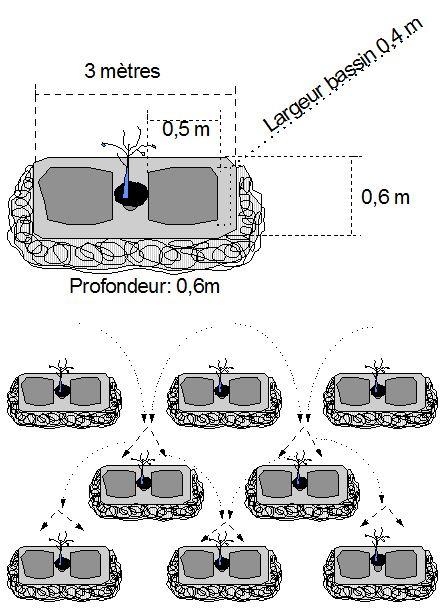
Technical specifications (related to technical drawing):

Trenches are manually excavated 3 to 3.5 m long and 0.6 m deep, spaced 4 m apart in staggered rows. This results in around 625 trenches per hectare. The excavated earth is piled downhill of the trenches, which are aligned perpendicular to the slope. In the middle of each trench, a 0.40 m high step is left on which the tree seedling is planted. The tree benefits from the water collected in the trench.

Technical knowledge required for field staff / advisors: moderate

Technical knowledge required for land users: low

Main technical functions: control of dispersed runoff: retain / trap, control of dispersed runoff: impede / retard, control of concentrated runoff: retain / trap, control of concentrated runoff: impede / retard, control of concentrated runoff: drain / divert, improvement of ground cover, stabilisation of soil (eg by tree roots against land slides), increase of infiltration, increase / maintain water stored in soil, water harvesting / increase water supply

Secondary technical functions: increase in organic matter, increase in nutrient availability (supply, recycling,…), increase of groundwater level / recharge of groundwater, sediment retention / trapping, sediment harvesting, reduction in wind speed, increase of biomass (quantity), promotion of vegetation species and varieties (quality, eg palatable fodder)

Vegetative measure: planted in trench
Vegetative material: T : trees / shrubs, G : grass

Vegetative measure: Vegetative material: T : trees / shrubs, G : grass

Retention/infiltration ditch/pit, sediment/sand trap
Spacing between structures (m): 4
Depth of ditches/pits/dams (m): 0.6
Length of ditches/pits/dams (m): 3.5

Vegetation is used for stabilisation of structures.

Author:

MDR, Niger: Reports

4.2 General information regarding the calculation of inputs and costs

Specify currency used for cost calculations:
  • USD

4.3 Establishment activities

Activity Timing (season)
1. marking out the contour line
2. laying out the trenches in staggered rows
3. digging two rectangular microcatchments separated horizontally by a flat surface
4. making a hole in the central area
5. planting the seedlings
6. sowing grass on the ridges

4.4 Costs and inputs needed for establishment

Specify input Unit Quantity Costs per Unit Total costs per input % of costs borne by land users
Labour All the Labour unit 1.0 220.76 220.76
Plant material Seedlings unit 1.0 41.55 41.55
Other Transport of seedlings unit 1.0 1.93 1.93
Total costs for establishment of the Technology 264.24
Total costs for establishment of the Technology in USD 264.24

4.5 Maintenance/ recurrent activities

Activity Timing/ frequency
1. A protection and monitoring system is required to ensure that grazing animals do not damage the young trees
2. dead trees must be replaced systematically during the first three years

4.7 Most important factors affecting the costs

Describe the most determinate factors affecting the costs:

Other costs
• equipment, such as jumper bars, shovels and axes
• 625 tree seedlings
• 15 kg of grass seed
• cost of transporting 2 cartloads of seedlings
• 120 seedlings to replace dead trees.

5. Natural and human environment

5.1 Climate

Annual rainfall
  • < 250 mm
  • 251-500 mm
  • 501-750 mm
  • 751-1,000 mm
  • 1,001-1,500 mm
  • 1,501-2,000 mm
  • 2,001-3,000 mm
  • 3,001-4,000 mm
  • > 4,000 mm
Agro-climatic zone
  • semi-arid

Thermal climate class: subtropics

5.2 Topography

Slopes on average:
  • flat (0-2%)
  • gentle (3-5%)
  • moderate (6-10%)
  • rolling (11-15%)
  • hilly (16-30%)
  • steep (31-60%)
  • very steep (>60%)
Landforms:
  • plateau/plains
  • ridges
  • mountain slopes
  • hill slopes
  • footslopes
  • valley floors
Altitudinal zone:
  • 0-100 m a.s.l.
  • 101-500 m a.s.l.
  • 501-1,000 m a.s.l.
  • 1,001-1,500 m a.s.l.
  • 1,501-2,000 m a.s.l.
  • 2,001-2,500 m a.s.l.
  • 2,501-3,000 m a.s.l.
  • 3,001-4,000 m a.s.l.
  • > 4,000 m a.s.l.
Comments and further specifications on topography:

Altitudinal zone: 200 m a.s.l.

Landforms: Also footslopes and valley floors

5.3 Soils

Soil depth on average:
  • very shallow (0-20 cm)
  • shallow (21-50 cm)
  • moderately deep (51-80 cm)
  • deep (81-120 cm)
  • very deep (> 120 cm)
Soil texture (topsoil):
  • medium (loamy, silty)
  • fine/ heavy (clay)
Topsoil organic matter:
  • low (<1%)
If available, attach full soil description or specify the available information, e.g. soil type, soil PH/ acidity, Cation Exchange Capacity, nitrogen, salinity etc.

Soil fertility is very low - medium

Soil drainage / infiltration is poor - medium

Soil water storage capacity is low - medium

5.4 Water availability and quality

Ground water table:

5-50 m

Availability of surface water:

medium

Water quality (untreated):

for agricultural use only (irrigation)

Comments and further specifications on water quality and quantity:

Ground water table: > 10m

Availability of surface water: Surface runoff generated by limited but intense rainfalls

5.5 Biodiversity

Species diversity:
  • low

5.6 Characteristics of land users applying the Technology

Market orientation of production system:
  • subsistence (self-supply)
  • mixed (subsistence/ commercial)
Off-farm income:
  • 10-50% of all income
Relative level of wealth:
  • very poor
  • poor
Level of mechanization:
  • manual work
  • animal traction
Gender:
  • men
Indicate other relevant characteristics of the land users:

Population density: 10-50 persons/km2

Annual population growth: 3% - 4%

(mostly poor households below poverty line).

Off-farm income specification: men migrate temporarily or permanently to cities for off-farm income, women and men seasonally carry out paid farm work

Market orientation of production system: Most households crop for subsistence , but surplus is sold on the market. Some vegetable growing is just for commercial/ market.

Level of mechanization: Oxes and donkeys used for animal traction.

5.7 Average area of land used by land users applying the Technology

  • < 0.5 ha
  • 0.5-1 ha
  • 1-2 ha
  • 2-5 ha
  • 5-15 ha
  • 15-50 ha
  • 50-100 ha
  • 100-500 ha
  • 500-1,000 ha
  • 1,000-10,000 ha
  • > 10,000 ha
Is this considered small-, medium- or large-scale (referring to local context)?
  • small-scale
Comments:

Average area of land owned or leased by land users applying the Technology: Also 1-2 ha

5.8 Land ownership, land use rights, and water use rights

Land ownership:
  • state
  • communal/ village
  • not titled
Land use rights:
  • individual
Comments:

Traditional land use rights prevail. On fields individual land use rights, communal rights on pasture and forest land (collection of wood and other products (fruits, medicinal plants))

5.9 Access to services and infrastructure

health:
  • poor
  • moderate
  • good
education:
  • poor
  • moderate
  • good
technical assistance:
  • poor
  • moderate
  • good
employment (e.g. off-farm):
  • poor
  • moderate
  • good
markets:
  • poor
  • moderate
  • good
energy:
  • poor
  • moderate
  • good
roads and transport:
  • poor
  • moderate
  • good
drinking water and sanitation:
  • poor
  • moderate
  • good
financial services:
  • poor
  • moderate
  • good

6. Impacts and concluding statements

6.1 On-site impacts the Technology has shown

Socio-economic impacts

Production

fodder production

decreased
increased

fodder quality

decreased
increased

wood production

decreased
increased

production area

decreased
increased
Income and costs

workload

increased
decreased

Socio-cultural impacts

SLM/ land degradation knowledge

reduced
improved

livelihood and human well-being

reduced
improved
Comments/ specify:

This technique permits the reintroduction of trees on degraded, unfertile land. Areas restored using hand-dug trenches can subsequently be exploited to a limited extent in accordance with strict controls.

Ecological impacts

Water cycle/ runoff

harvesting/ collection of water

reduced
improved

surface runoff

increased
decreased

excess water drainage

reduced
improved

groundwater table/ aquifer

lowered
recharge
Soil

soil moisture

decreased
increased

soil cover

reduced
improved

soil loss

increased
decreased

soil crusting/ sealing

increased
reduced

nutrient cycling/ recharge

decreased
increased
Biodiversity: vegetation, animals

biomass/ above ground C

decreased
increased

plant diversity

decreased
increased
Climate and disaster risk reduction

wind velocity

increased
decreased

6.2 Off-site impacts the Technology has shown

downstream flooding

increased
reduced

downstream siltation

increased
decreased

wind transported sediments

increased
reduced

6.3 Exposure and sensitivity of the Technology to gradual climate change and climate-related extremes/ disasters (as perceived by land users)

Gradual climate change

Gradual climate change
Season increase or decrease How does the Technology cope with it?
annual temperature increase well

Climate-related extremes (disasters)

Meteorological disasters
How does the Technology cope with it?
local rainstorm not well
local windstorm well
Climatological disasters
How does the Technology cope with it?
drought well
Hydrological disasters
How does the Technology cope with it?
general (river) flood not well

Other climate-related consequences

Other climate-related consequences
How does the Technology cope with it?
reduced growing period not known
Comments:

Damages are generally small but need to be repaired quickly.

6.4 Cost-benefit analysis

How do the benefits compare with the establishment costs (from land users’ perspective)?
Short-term returns:

slightly negative

Long-term returns:

slightly positive

How do the benefits compare with the maintenance/ recurrent costs (from land users' perspective)?
Short-term returns:

slightly negative

Long-term returns:

slightly positive

Comments:

Establishment of the trenches involves considerable labour and growth of trees takes a couple of years.

6.5 Adoption of the Technology

Of all those who have adopted the Technology, how many did so spontaneously, i.e. without receiving any material incentives/ payments?
  • 0-10%
Comments:

Comments on acceptance with external material support: The technology has been applied by PDRT on common land using food/cash for work in order to inject money and food into the local communities.

Comments on spontaneous adoption: There was no spontaneous adoption. The technology is designed for common lands and takes considerable labour that only very well organised communities are able to mobilise.

There is no trend towards spontaneous adoption of the Technology

6.7 Strengths/ advantages/ opportunities of the Technology

Strengths/ advantages/ opportunities in the land user’s view
The young trees are protected of flooding, as they are planted on a raised step within the trench
Strengths/ advantages/ opportunities in the compiler’s or other key resource person’s view
Hand-dug trenches retain water and make it available to the trees growing in them. Although the trenches are progressively filled with sediment, which reduces their capacity to retain water, at the same time, the trees develop and become less dependent on stored water.
This technique has proved effective in restoring forest/rangeland sites. The progressive development of grass and tree cover continues on the improved sites, where the tree population is up to 20 years old. After around ten years, the average annual production of wood is 1.3 steres per hectare.
The shade provided by the trees also lowers the temperature of the soil.
In the medium term, this technique is effective
in protecting the land against water and wind erosion.
Areas restored using hand-dug trenches can subsequently be exploited to a limited extent in accordance with strict controls.

6.8 Weaknesses/ disadvantages/ risks of the Technology and ways of overcoming them

Weaknesses/ disadvantages/ risks in the compiler’s or other key resource person’s view How can they be overcome?
The technique is very labour intensive. Work must begin immediately after harvesting when the soil is still moist and workable. Good community organisation is required.
A protection and monitoring system is required to ensure that grazing animals do not damage the young trees. The mortality of trees after planting is relatively high (survival rate is about 60%), and dead trees must be replaced systematically during the first three years.

7. References and links

7.1 Methods/ sources of information

7.3 Links to relevant online information

Title/ description:

Good Practices in Soil and Water Conservation. A contribution to adaptation and farmers´ resilience towards climate change in the Sahel. Published by GIZ in 2012.

URL:

http://agriwaterpedia.info/wiki/Main_Page

Links and modules

Expand all Collapse all

Modules