Cyclopean concrete micro-dams [Mali]
- Creation:
- Update:
- Compiler: Dieter Nill
- Editor: –
- Reviewers: Deborah Niggli, Alexandra Gavilano
Micro-barrage en béton cyclopéen (French)
technologies_1634 - Mali
View sections
Expand all Collapse all1. General information
1.2 Contact details of resource persons and institutions involved in the assessment and documentation of the Technology
SLM specialist:
Kone Mamadou Gallo
IPRO-DB Bélédougou
Mali
SLM specialist:
Schneider Ralf
IPRO-DB Bélédougou
Mali
Name of project which facilitated the documentation/ evaluation of the Technology (if relevant)
Manual of Good Practices in Small Scale Irrigation in the Sahel (GIZ )Name of the institution(s) which facilitated the documentation/ evaluation of the Technology (if relevant)
Deutsche Gesellschaft für Internationale Zusammenarbeit (GIZ) - Germany1.3 Conditions regarding the use of data documented through WOCAT
The compiler and key resource person(s) accept the conditions regarding the use of data documented through WOCAT:
Yes
1.4 Declaration on sustainability of the described Technology
Is the Technology described here problematic with regard to land degradation, so that it cannot be declared a sustainable land management technology?
No
2. Description of the SLM Technology
2.1 Short description of the Technology
Definition of the Technology:
A water reservoir for growing off-season increases the farmed area, yields and production. A second growing season thus becomes possible.
2.2 Detailed description of the Technology
Description:
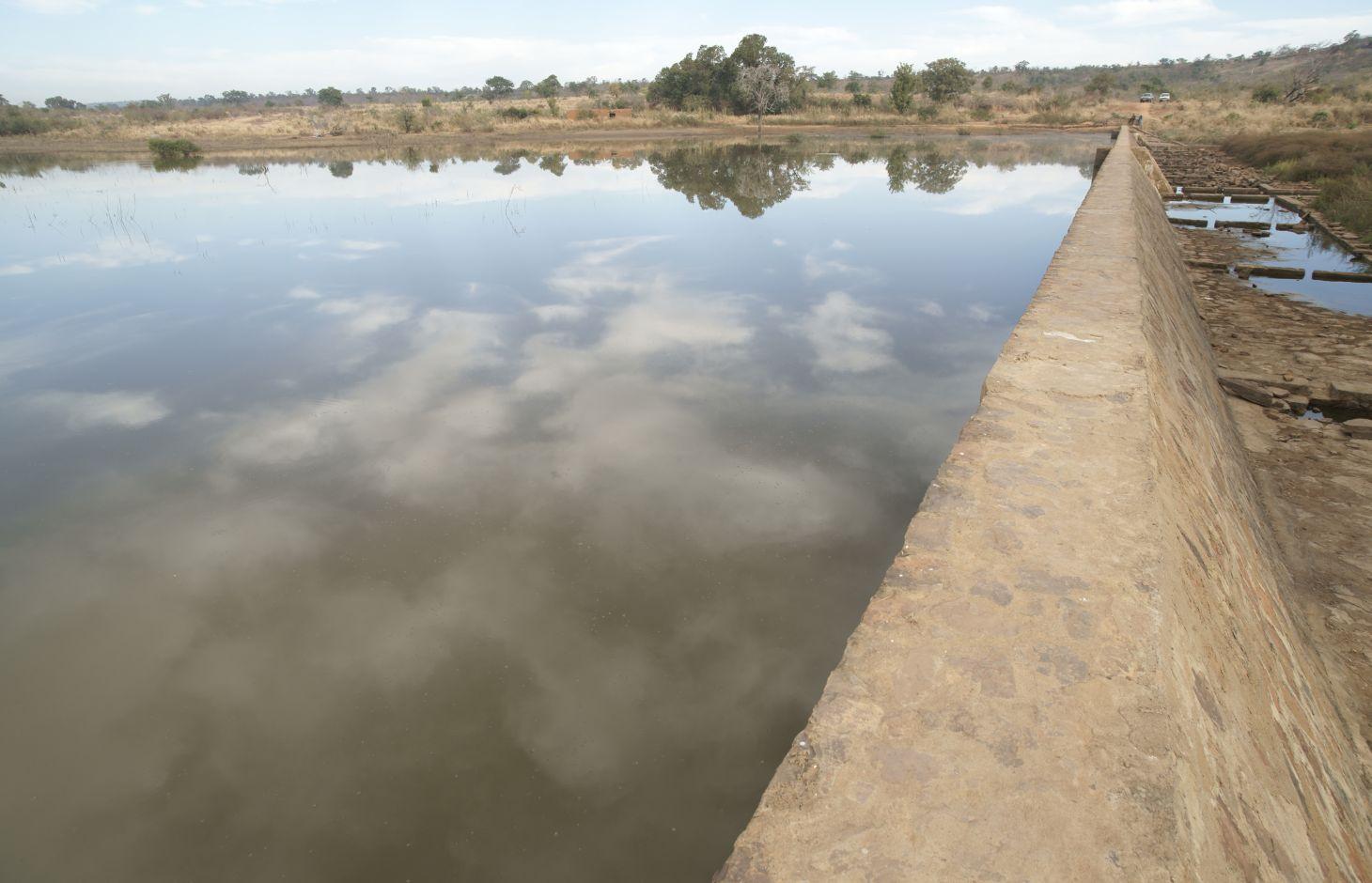
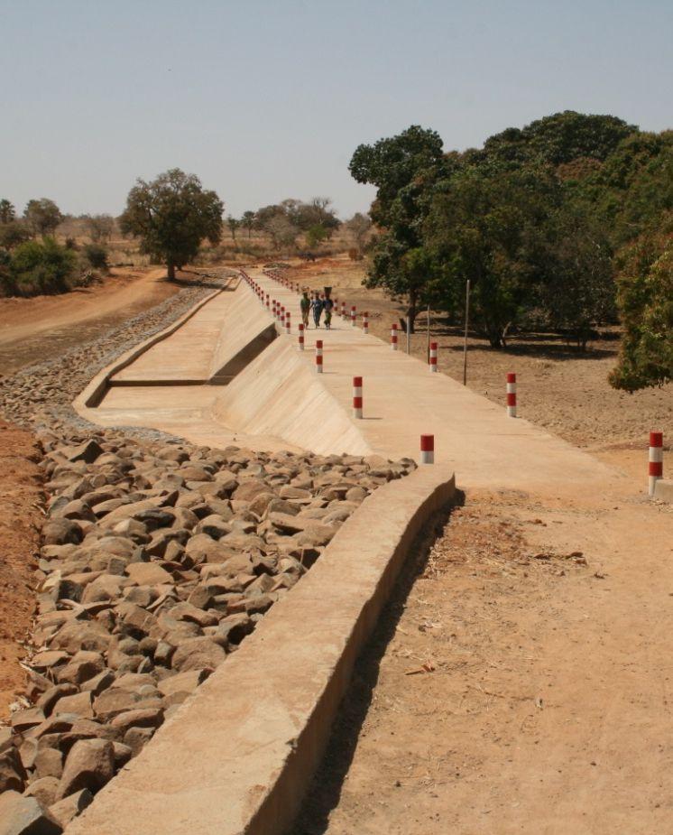
A cyclopean concrete micro-dam is built using dressed stone pointed with concrete. Cyclopean concrete is stronger than rubble stone masonry. The width of the crest is 0.75 metres. The length generally ranges from 150 to 250 metres depending on the site. The height varies between two and four metres. Micro-dams are equipped with buttresses and a stilling basin. The dam can be built in the form of a dam bridge. Each dam is has a stoplog sluice for draining away sediment during the first rains of the season and to regulate water levels. The use of stoplog gates is recommended instead of sluice gates, as the latter are more technically sophisticated and require more maintenance. The dam creates a water reservoir upstream covering an area of between 4 and 15 hectares.
Farming is carried out upstream and downstream in the rainy season and off-season.
The dam increases the amount of available surface water during the rainy season and groundwater during the off-season. Its effect on the water table depends on the depth of the scheme’s foundations: the deeper the foundations, the greater the recharge of ground water.
During the rainy season, the areas are used for rice growing. The wells used for irrigating market gardens are fed from the water table, meaning vegetables can be grown off-season. The water is also used for watering livestock, fish farming and, sometimes, domestic purposes. The dam increases the farmland areas, production and yields. Higher farming revenues lead to improved living conditions.
Initially, an information and awareness-raising workshop on the IPRO-DB approach is organised at the commune level, involving the villages affected by the project. Following this, a general meeting is held to secure the support of the whole village for the development request. The village chief and commune mayor then sign off the request. The project team carries out a scoping study and socio-economic surveys. If the outcomes of the scoping studies and socio-economic surveys are positive, the project team draws up the terms of reference for working with the consultancies. This stage is followed by the selection of consultancies through tender processes to carry out the technical studies and produce the invitation to tender document, all of which will be overseen by the project team. The village then makes its financial contribution towards the project, the management committee is set up, and organisational and technical training is provided to beneficiaries. The final stages comprise the partial acceptance of the building works (for example, foundations, wall, buttresses, stilling basin, gabion reinforcements, etc.), the monitoring of scheme building works by the project team, payment for activities on a unit-price basis, and interim acceptance leading to final acceptance after one year. A management committee takes charge of opening and closing the stoplog gates, organises the maintenance of the scheme and institutes additional measures to protect the scheme (gabions, stone bunds, etc.). It collects and manages maintenance fees, ensures the committee’s rules of procedure are adhered to and organises meetings of local producers. With minimum levels of maintenance, a scheme will remain functional for at least 20 years. Sustainable farming and management depend directly on employing a participatory approach.
Roles of the actors involved: Beneficiaries provide labour and financial resources, and conduct monitoring and the small-scale maintenance of the scheme. The project team provides funding, training and beneficiary support, carries out studies and capitalises on project data. The commune signs off the village request and repairs major damage (an activity that has so far been undertaken by the project team). Consultancies and contractors conduct surveys, carry out building work and are responsible for oversight. Rural engineers: quarterly inspections are carried out by the Regional Directorate of Rural Engineering and the Regional Directorate of Agriculture.
Since 2010, four dams were built so far in the Kolokani Circle (Tiembougou, Bamabougou, Korokabougou, Tienko). Others are currently being planned. The practice is recommended for areas lacking the right kind of stone for dressing (dolerite).
2.3 Photos of the Technology
Media Gallery
2.5 Country/ region/ locations where the Technology has been applied and which are covered by this assessment
Country:
Mali
Region/ State/ Province:
Mali
Further specification of location:
Kolokani Circle (Tiembougou, Bamabougou, Korokabougou, Tienko)
Specify the spread of the Technology:
- evenly spread over an area
If precise area is not known, indicate approximate area covered:
- 0.1-1 km2
Comments:
Four dams built so far. Others are currently being planned.
2.6 Date of implementation
If precise year is not known, indicate approximate date:
- less than 10 years ago (recently)
2.7 Introduction of the Technology
Specify how the Technology was introduced:
- through projects/ external interventions
Comments (type of project, etc.):
since 2010 by IPRO-DB Bélédougou
3. Classification of the SLM Technology
3.1 Main purpose(s) of the Technology
- improve production
3.2 Current land use type(s) where the Technology is applied
Land use mixed within the same land unit:
Yes
Specify mixed land use (crops/ grazing/ trees):
- Agro-silvopastoralism

Cropland
- Annual cropping
Number of growing seasons per year:
- 1
Specify:
Longest growing period in days: 120, Longest growing period from month to month: August-November

Waterways, waterbodies, wetlands
- Ponds, dams
Comments:
Major land use problems (compiler’s opinion): lack and loss of surface water and groundwater
Livestock density: 1-10 LU /km2
3.4 Water supply
Water supply for the land on which the Technology is applied:
- mixed rainfed-irrigated
3.5 SLM group to which the Technology belongs
- irrigation management (incl. water supply, drainage)
- water diversion and drainage
- surface water management (spring, river, lakes, sea)
3.6 SLM measures comprising the Technology

structural measures
- S5: Dams, pans, ponds
3.7 Main types of land degradation addressed by the Technology

biological degradation
- Bc: reduction of vegetation cover

water degradation
- Ha: aridification
- Hs: change in quantity of surface water
- Hg: change in groundwater/aquifer level
Comments:
Main causes of degradation: over abstraction / excessive withdrawal of water (for irrigation, industry, etc.)
3.8 Prevention, reduction, or restoration of land degradation
Specify the goal of the Technology with regard to land degradation:
- prevent land degradation
- restore/ rehabilitate severely degraded land
4. Technical specifications, implementation activities, inputs, and costs
4.1 Technical drawing of the Technology
Technical specifications (related to technical drawing):
Technical knowledge required for field staff / advisors: high
Technical knowledge required for land users: low
Main technical functions: increase of infiltration, increase / maintain water stored in soil, increase of groundwater level / recharge of groundwater, water harvesting / increase water supply, water spreading
Dam/ pan/ pond
Depth of ditches/pits/dams (m): 2-4
Width of ditches/pits/dams (m): 0.75
Length of ditches/pits/dams (m): 150-250
4.2 General information regarding the calculation of inputs and costs
other/ national currency (specify):
CFA Franc
If relevant, indicate exchange rate from USD to local currency (e.g. 1 USD = 79.9 Brazilian Real): 1 USD =:
517.0
4.3 Establishment activities
| Activity | Timing (season) | |
|---|---|---|
| 1. | information and awareness-raising workshop on the IPRO-DB approach is organised at the commune level | |
| 2. | a general meeting is held to secure the support of the whole village for the development request | |
| 3. | The project team carries out a scoping study and socio-economic surveys | |
| 4. | draw up the terms of reference for working with the consultancies | |
| 5. | carry out the technical studies | |
| 6. | management committee is set up, and organisational and technical training is provided to beneficiaries | |
| 7. | building works (foundations, wall, buttresses, stilling basin, gabion reinforcements, etc.), |
4.4 Costs and inputs needed for establishment
| Specify input | Unit | Quantity | Costs per Unit | Total costs per input | % of costs borne by land users | |
|---|---|---|---|---|---|---|
| Other | total construction | 1.0 | 271379.0 | 271379.0 | 100.0 | |
| Total costs for establishment of the Technology | 271379.0 | |||||
| Total costs for establishment of the Technology in USD | 524.91 | |||||
4.5 Maintenance/ recurrent activities
| Activity | Timing/ frequency | |
|---|---|---|
| 1. | A management committee takes charge of opening and closing the stoplog gates, organises the maintenance of the scheme and institutes additional measures to protect the scheme (gabions, stone bunds, etc.). It collects and manages maintenance fees, ensures the committee’s rules of procedure are adhered to and organises meetings of local producers. |
4.7 Most important factors affecting the costs
Describe the most determinate factors affecting the costs:
Each dam costs between 100 and 140 million CFA francs (193'851-271'379 Dollar)
5. Natural and human environment
5.1 Climate
Annual rainfall
- < 250 mm
- 251-500 mm
- 501-750 mm
- 751-1,000 mm
- 1,001-1,500 mm
- 1,501-2,000 mm
- 2,001-3,000 mm
- 3,001-4,000 mm
- > 4,000 mm
Agro-climatic zone
- semi-arid
Thermal climate class: tropics
5.2 Topography
Slopes on average:
- flat (0-2%)
- gentle (3-5%)
- moderate (6-10%)
- rolling (11-15%)
- hilly (16-30%)
- steep (31-60%)
- very steep (>60%)
Landforms:
- plateau/plains
- ridges
- mountain slopes
- hill slopes
- footslopes
- valley floors
Altitudinal zone:
- 0-100 m a.s.l.
- 101-500 m a.s.l.
- 501-1,000 m a.s.l.
- 1,001-1,500 m a.s.l.
- 1,501-2,000 m a.s.l.
- 2,001-2,500 m a.s.l.
- 2,501-3,000 m a.s.l.
- 3,001-4,000 m a.s.l.
- > 4,000 m a.s.l.
5.3 Soils
Soil depth on average:
- very shallow (0-20 cm)
- shallow (21-50 cm)
- moderately deep (51-80 cm)
- deep (81-120 cm)
- very deep (> 120 cm)
Soil texture (topsoil):
- medium (loamy, silty)
- fine/ heavy (clay)
Topsoil organic matter:
- medium (1-3%)
- low (<1%)
5.4 Water availability and quality
Ground water table:
5-50 m
Availability of surface water:
medium
Water quality (untreated):
for agricultural use only (irrigation)
5.5 Biodiversity
Species diversity:
- medium
5.6 Characteristics of land users applying the Technology
Market orientation of production system:
- mixed (subsistence/ commercial)
Off-farm income:
- 10-50% of all income
Relative level of wealth:
- poor
- average
Level of mechanization:
- manual work
Gender:
- men
Indicate other relevant characteristics of the land users:
Population density: < 10 persons/km2
Annual population growth: 2% - 3%
10% of the land users are rich.
50% of the land users are average wealthy.
30% of the land users are poor.
10% of the land users are very poor.
5.7 Average area of land used by land users applying the Technology
- < 0.5 ha
- 0.5-1 ha
- 1-2 ha
- 2-5 ha
- 5-15 ha
- 15-50 ha
- 50-100 ha
- 100-500 ha
- 500-1,000 ha
- 1,000-10,000 ha
- > 10,000 ha
Is this considered small-, medium- or large-scale (referring to local context)?
- small-scale
5.8 Land ownership, land use rights, and water use rights
Comments:
The irrigated land is allocated by the chief
5.9 Access to services and infrastructure
health:
- poor
- moderate
- good
education:
- poor
- moderate
- good
technical assistance:
- poor
- moderate
- good
employment (e.g. off-farm):
- poor
- moderate
- good
markets:
- poor
- moderate
- good
energy:
- poor
- moderate
- good
roads and transport:
- poor
- moderate
- good
drinking water and sanitation:
- poor
- moderate
- good
financial services:
- poor
- moderate
- good
6. Impacts and concluding statements
6.1 On-site impacts the Technology has shown
Socio-economic impacts
Production
crop production
risk of production failure
production area
Income and costs
farm income
Socio-cultural impacts
food security/ self-sufficiency
conflict mitigation
contribution to human well-being
Comments/ specify:
Increased farming revenues lead to improved living conditions
Ecological impacts
Water cycle/ runoff
water quantity
harvesting/ collection of water
groundwater table/ aquifer
Soil
soil moisture
6.3 Exposure and sensitivity of the Technology to gradual climate change and climate-related extremes/ disasters (as perceived by land users)
Gradual climate change
Gradual climate change
| Season | increase or decrease | How does the Technology cope with it? | |
|---|---|---|---|
| annual temperature | increase | well |
Climate-related extremes (disasters)
Meteorological disasters
| How does the Technology cope with it? | |
|---|---|
| local rainstorm | well |
| local windstorm | well |
Climatological disasters
| How does the Technology cope with it? | |
|---|---|
| drought | well |
Hydrological disasters
| How does the Technology cope with it? | |
|---|---|
| general (river) flood | well |
Other climate-related consequences
Other climate-related consequences
| How does the Technology cope with it? | |
|---|---|
| reduced growing period | well |
6.4 Cost-benefit analysis
How do the benefits compare with the establishment costs (from land users’ perspective)?
Short-term returns:
positive
Long-term returns:
positive
How do the benefits compare with the maintenance/ recurrent costs (from land users' perspective)?
Short-term returns:
positive
Long-term returns:
positive
6.7 Strengths/ advantages/ opportunities of the Technology
| Strengths/ advantages/ opportunities in the compiler’s or other key resource person’s view |
|---|
| The dam increases the amount of available surface water during the rainy season and groundwater during the off-season. The wells used for irrigating market gardens are fed from the water table, meaning vegetables can be grown off-season. The water is also used for watering livestock, fish farming and, sometimes, domestic purposes. |
| Generation of year-round employment results in a reduction of seasonal outmigration |
| Increased farming revenues lead to improved living conditions |
| Increased farmland areas, increased production and yields |
6.8 Weaknesses/ disadvantages/ risks of the Technology and ways of overcoming them
| Weaknesses/ disadvantages/ risks in the compiler’s or other key resource person’s view | How can they be overcome? |
|---|---|
| There is an occasional lack of monitoring and maintenance. |
7. References and links
7.1 Methods/ sources of information
- field visits, field surveys
- interviews with land users
When were the data compiled (in the field)?
01/07/2012
7.2 References to available publications
Title, author, year, ISBN:
Manual of Good Practices in Small Scale Irrigation in the Sahel. Experiences from Mali. Published by GIZ in 2014.
Available from where? Costs?
http://star-www.giz.de/starweb/giz/pub/servlet.starweb
Title, author, year, ISBN:
IPRO-DB (2007): Fiches techniques des barrages individuels. [Data sheets on individual dams]
Title, author, year, ISBN:
IPRO-DB: Module de formation pour la préparation des aménagements [Training module on preparing schemes] (available in French and Bambara)
Title, author, year, ISBN:
IPRO-DB: Module de formation sur l’entretien des ouvrages [Training module on scheme maintenance] (available inFrench and Bambara)
Title, author, year, ISBN:
IPRO-DB: Approches du projet de l’irrigation de proximité au Pays Dogon et dans le Bélédougou [Small-scale irrigation project approaches in Dogon Country and in the Bélédougou region], (O. Fritz, Technical Assistant, GIZ, December 2011)
Links and modules
Expand all Collapse allLinks
No links
Modules
No modules