Deepening the channels supplying water to lakes and ponds [Mali]
- Creation:
- Update:
- Compiler: Dieter Nill
- Editor: –
- Reviewers: Deborah Niggli, Alexandra Gavilano
Surcreusement des canaux d’alimentation en eau des lacs et des mares (French)
technologies_1635 - Mali
View sections
Expand all Collapse all1. General information
1.2 Contact details of resource persons and institutions involved in the assessment and documentation of the Technology
SLM specialist:
Coulibaly Bakary Sékou
IFAD
Mali
SLM specialist:
Nadio Mamadou
National Coordinator for IFAD In- Country Programmes
Mali
Name of project which facilitated the documentation/ evaluation of the Technology (if relevant)
Manual of Good Practices in Small Scale Irrigation in the Sahel (GIZ )Name of the institution(s) which facilitated the documentation/ evaluation of the Technology (if relevant)
Deutsche Gesellschaft für Internationale Zusammenarbeit (GIZ) - Germany1.3 Conditions regarding the use of data documented through WOCAT
The compiler and key resource person(s) accept the conditions regarding the use of data documented through WOCAT:
Yes
1.4 Declaration on sustainability of the described Technology
Is the Technology described here problematic with regard to land degradation, so that it cannot be declared a sustainable land management technology?
No
2. Description of the SLM Technology
2.1 Short description of the Technology
Definition of the Technology:
The deepening of the channels has made it possible to control pond and lake recharge, optimise yields and crop growing, and increase the area under cultivation.
2.2 Detailed description of the Technology
Description:
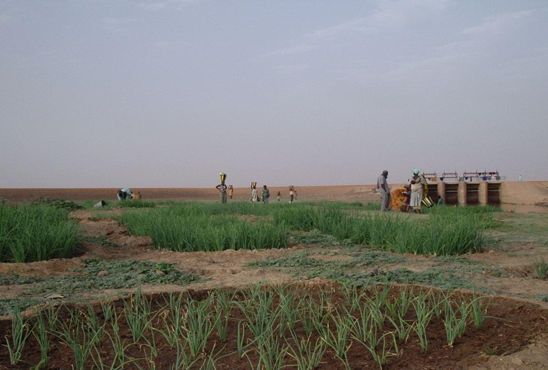
The water for the lakes and ponds in the lakeland area (‘zone lacustre’) alongside the Niger River is supplied when the Niger is in spate by means of a system of natural channels. As the water height of the annual flood wave of the Niger has decreased, some lakes and ponds receive little water. The disadvantages of this natural system are: the loss of harvests due to the flooding of fields before the crops have time to mature, and the rapid retreat of waters that inhibits the capillary effect across large areas.
In relation to the building of control structures and the deepening of channels supplying water to ponds and lakes, the projects main objectives are to: restore water supplies to the lakes and ponds previously fed by the Niger River; regularise water supplies to the ponds and lakes; increase the area under cultivation; restart the growing of flood recession crops and other activities in the areas around ponds and lakes; restore the environment and biodiversity around ponds and lakes; raise the water table around the ponds and lakes.
The deepening of the channels has made it possible to recharge lake and pond basins. It is the reason why we are now seeing the resumption of farming, market gardening, animal husbandry and fishing around the lakes and ponds. By building control structures and large dykes it is possible to control pond and lake recharge, optimise yields and crop growing, and increase the area under cultivation. There is a diversification of production and incomes through the farming of small family units and market gardening plots in the lake and pond areas. The installation of bridge crossings with causeways running across marshlands have helped to open up the area and, as such, facilitate the transport of farm produce, the provisioning of local communities and the circulation of road traffic. The development of the dual road/ferry scheme (the Saraféré-Niafunké road and 40-tonne motor ferry) has revived an economic and human activity that was dying out due to extremely high levels of male outmigration, which left women running households and highly vulnerable.
The stages of initiating, planning and implementing works and installations are based on the studies (soil, topographical and socio-economic) carried out by a consultancy and private company recruited through a tender process to deliver the works according to a well-defined timetable. An oversight and control office undertakes the monitoring and control of works quality and the meeting of agreed deadlines.
In principle, works are carried out during low-water periods when most of the floodplains are dry. The swampy nature of the area makes any intervention in the rainy season impossible. Furthermore, the planning of activities must respect the constraints imposed by nature. The Dabi installation on Lake Takadji is a good example of the application of technical standards.
The application and modus operandi of this good practice involve the following: the water inlets for the lake and pond basins alongside the Niger River are reopened by deepening the feeder channels; the high waters of the Niger River feed the ponds and lakes; water supply is controlled using a cement structure fitted with gates to prevent: the water flow from reversing when the Niger’s water levels are low, water flowing into the ponds and lakes before harvesting is complete; flood gauges to measure annual high water levels.
Various actors are involved in delivering this practice. Their roles are as follows: Beneficiaries are not required to participate in works delivered by contractors (works involving large pond and lakes), but they take charge of the development of VIS plots with support from the World Food Programme (WFP) in the form of supplies. External support from the project/programme finances the installation of facilities, the pump units and the first season’s inputs. Consultancies undertake feasibility studies, produce project specifications and plans, and carry out the monitoring and oversight of works. Local authorities, as a general rule, are involved in the planning of activities or, alternatively, make provision for activities in the PDESC. They also handle the upkeep and maintenance of installations.
2.3 Photos of the Technology
Media Gallery

2.5 Country/ region/ locations where the Technology has been applied and which are covered by this assessment
Country:
Mali
Region/ State/ Province:
Mali
Further specification of location:
Timbuktu Region; Niafunké, Diré and Goundam circles; communes of Soboundou, Soumpi, Tonka, Tindirma
Specify the spread of the Technology:
- evenly spread over an area
If the Technology is evenly spread over an area, specify area covered (in km2):
332.0
Comments:
Total area covered by the SLM Technology is 332 km2.
In terms of the ponds and lakes, the following objectives were achieved:
Six large ponds were rehabilitated: Fati (13,000 hectares), Takadji (9,000 hectares) and Ganga (3,000 hectares), making a total of 25,000 hectares, Koboro (4,000 hectares), Kassoum-Soumpi (1,000 hectares), Billi I and Billi II (2,000 hectares), the Nounou-Diengo causeway on Lake Takadji (an additional 1,200 hectares), making a total of 8,200 hectares
Area involved: 33,200 hectares
Number of beneficiaries: 190,000 producers
2.6 Date of implementation
If precise year is not known, indicate approximate date:
- 10-50 years ago
2.7 Introduction of the Technology
Specify how the Technology was introduced:
- through projects/ external interventions
Comments (type of project, etc.):
This good practice has been used for around 20 years (since 1990) in IFAD projects in the ‘zone lacustre’ (lake zone).
3. Classification of the SLM Technology
3.1 Main purpose(s) of the Technology
- improve production
3.2 Current land use type(s) where the Technology is applied
Land use mixed within the same land unit:
Yes
Specify mixed land use (crops/ grazing/ trees):
- Agro-pastoralism (incl. integrated crop-livestock)

Cropland
- Annual cropping
Number of growing seasons per year:
- 1
Specify:
Longest growing period in days: 120, Longest growing period from month to month: August-November

Grazing land
Comments:
Major land use problems (compiler’s opinion): the loss of harvests due to the flooding of fields before the crops have time to mature, and the rapid retreat of waters that inhibits the capillary effect across large areas
Livestock density: 1-10 LU /km2
3.4 Water supply
Water supply for the land on which the Technology is applied:
- mixed rainfed-irrigated
3.5 SLM group to which the Technology belongs
- irrigation management (incl. water supply, drainage)
- water diversion and drainage
- surface water management (spring, river, lakes, sea)
3.6 SLM measures comprising the Technology

structural measures
- S3: Graded ditches, channels, waterways
3.7 Main types of land degradation addressed by the Technology

water degradation
- Ha: aridification
- Hs: change in quantity of surface water
- Hg: change in groundwater/aquifer level
Comments:
Main causes of degradation: over abstraction / excessive withdrawal of water (for irrigation, industry, etc.), change of seasonal rainfall
3.8 Prevention, reduction, or restoration of land degradation
Specify the goal of the Technology with regard to land degradation:
- restore/ rehabilitate severely degraded land
4. Technical specifications, implementation activities, inputs, and costs
4.1 Technical drawing of the Technology

Technical specifications (related to technical drawing):
Map of the ZLDP/NKE intervention area, phases I and II
Technical knowledge required for field staff / advisors: high
Technical knowledge required for land users: low
Main technical functions: increase of groundwater level / recharge of groundwater, water harvesting / increase water supply, recharge lake and pond basins
Secondary technical functions: control of dispersed runoff: retain / trap, increase / maintain water stored in soil
4.2 General information regarding the calculation of inputs and costs
other/ national currency (specify):
CFA Franc
If relevant, indicate exchange rate from USD to local currency (e.g. 1 USD = 79.9 Brazilian Real): 1 USD =:
517.0
4.3 Establishment activities
| Activity | Timing (season) | |
|---|---|---|
| 1. | the water inlets for the lake and pond basins alongside the Niger River are reopened by deepening the feeder channels | |
| 2. | the high waters of the Niger River feed the ponds and lakes | |
| 3. | water supply is controlled using a cement structure fitted with gates to prevent: the water flow from reversing when the Niger’s water levels are low, water flowing into the ponds and lakes before harvesting is complete; flood gauges to measure annual high water levels. |
4.4 Costs and inputs needed for establishment
| Specify input | Unit | Quantity | Costs per Unit | Total costs per input | % of costs borne by land users | |
|---|---|---|---|---|---|---|
| Other | total construction | ha | 1.0 | 580.0 | 580.0 | 100.0 |
| Total costs for establishment of the Technology | 580.0 | |||||
| Total costs for establishment of the Technology in USD | 1.12 | |||||
4.5 Maintenance/ recurrent activities
| Activity | Timing/ frequency | |
|---|---|---|
| 1. | upkeep and maintenance of installations |
4.7 Most important factors affecting the costs
Describe the most determinate factors affecting the costs:
The average cost of large ponds is around 300,000 CFA francs per hectare (580 Dollar per hectare). The VIS installation works were conducted using a participatory approach. The project contributed 780,106 CFA francs towards the VIS installation, or 65%, whereas the farmers’ contribution was 429,079 CFA francs per hectare, or 35%.
5. Natural and human environment
5.1 Climate
Annual rainfall
- < 250 mm
- 251-500 mm
- 501-750 mm
- 751-1,000 mm
- 1,001-1,500 mm
- 1,501-2,000 mm
- 2,001-3,000 mm
- 3,001-4,000 mm
- > 4,000 mm
Agro-climatic zone
- semi-arid
Thermal climate class: tropics
5.2 Topography
Slopes on average:
- flat (0-2%)
- gentle (3-5%)
- moderate (6-10%)
- rolling (11-15%)
- hilly (16-30%)
- steep (31-60%)
- very steep (>60%)
Landforms:
- plateau/plains
- ridges
- mountain slopes
- hill slopes
- footslopes
- valley floors
Altitudinal zone:
- 0-100 m a.s.l.
- 101-500 m a.s.l.
- 501-1,000 m a.s.l.
- 1,001-1,500 m a.s.l.
- 1,501-2,000 m a.s.l.
- 2,001-2,500 m a.s.l.
- 2,501-3,000 m a.s.l.
- 3,001-4,000 m a.s.l.
- > 4,000 m a.s.l.
5.3 Soils
Soil depth on average:
- very shallow (0-20 cm)
- shallow (21-50 cm)
- moderately deep (51-80 cm)
- deep (81-120 cm)
- very deep (> 120 cm)
Soil texture (topsoil):
- medium (loamy, silty)
- fine/ heavy (clay)
Topsoil organic matter:
- medium (1-3%)
- low (<1%)
5.4 Water availability and quality
Ground water table:
5-50 m
Availability of surface water:
medium
Water quality (untreated):
for agricultural use only (irrigation)
5.5 Biodiversity
Species diversity:
- medium
5.6 Characteristics of land users applying the Technology
Market orientation of production system:
- mixed (subsistence/ commercial)
Off-farm income:
- 10-50% of all income
Relative level of wealth:
- poor
- average
Level of mechanization:
- manual work
Gender:
- men
Indicate other relevant characteristics of the land users:
Population density: < 10 persons/km2
Annual population growth: 2% - 3%
10% of the land users are rich.
50% of the land users are average wealthy.
30% of the land users are poor.
10% of the land users are very poor.
5.7 Average area of land used by land users applying the Technology
- < 0.5 ha
- 0.5-1 ha
- 1-2 ha
- 2-5 ha
- 5-15 ha
- 15-50 ha
- 50-100 ha
- 100-500 ha
- 500-1,000 ha
- 1,000-10,000 ha
- > 10,000 ha
Is this considered small-, medium- or large-scale (referring to local context)?
- small-scale
5.8 Land ownership, land use rights, and water use rights
Comments:
The irrigated land is allocated by the chief
5.9 Access to services and infrastructure
health:
- poor
- moderate
- good
education:
- poor
- moderate
- good
technical assistance:
- poor
- moderate
- good
employment (e.g. off-farm):
- poor
- moderate
- good
markets:
- poor
- moderate
- good
energy:
- poor
- moderate
- good
roads and transport:
- poor
- moderate
- good
drinking water and sanitation:
- poor
- moderate
- good
financial services:
- poor
- moderate
- good
6. Impacts and concluding statements
6.1 On-site impacts the Technology has shown
Socio-economic impacts
Production
crop production
risk of production failure
product diversity
production area
Income and costs
farm income
Other socio-economic impacts
development of new farming technologies
facilitation of transport through the installation of bridges
Socio-cultural impacts
food security/ self-sufficiency
conflict mitigation
contribution to human well-being
Comments/ specify:
Increases in agro-sylvo-pastoral production, increases in local people’s incomes and standard of living. Rice production on a quarter-hectare VIS can increase family income by around 80% compared to traditional means of production involving 1.5 hectares of floating rice grown on the river. The percentage of households that are vulnerable to food insecurity has dropped from 20.4% in 1997 to 5.8% in 2006.
Ecological impacts
Water cycle/ runoff
water quantity
harvesting/ collection of water
groundwater table/ aquifer
Soil
soil moisture
Biodiversity: vegetation, animals
habitat diversity
Other ecological impacts
recharge of lakes and ponds
6.2 Off-site impacts the Technology has shown
water availability
6.3 Exposure and sensitivity of the Technology to gradual climate change and climate-related extremes/ disasters (as perceived by land users)
Gradual climate change
Gradual climate change
| Season | increase or decrease | How does the Technology cope with it? | |
|---|---|---|---|
| annual temperature | increase | well |
Climate-related extremes (disasters)
Meteorological disasters
| How does the Technology cope with it? | |
|---|---|
| local rainstorm | well |
| local windstorm | well |
Climatological disasters
| How does the Technology cope with it? | |
|---|---|
| drought | well |
Hydrological disasters
| How does the Technology cope with it? | |
|---|---|
| general (river) flood | well |
Other climate-related consequences
Other climate-related consequences
| How does the Technology cope with it? | |
|---|---|
| reduced growing period | well |
6.4 Cost-benefit analysis
How do the benefits compare with the establishment costs (from land users’ perspective)?
Short-term returns:
positive
Long-term returns:
very positive
How do the benefits compare with the maintenance/ recurrent costs (from land users' perspective)?
Short-term returns:
very positive
Long-term returns:
very positive
6.5 Adoption of the Technology
Comments:
The VIS installation works were conducted using a participatory approach. The project contributed 780'106 CFA francs towards the VIS installation, or 65%, whereas the farmers’ contribution was 429'079 CFA francs per hectare, or 35%.
In terms of the ponds and lakes, the following objectives were achieved: Six large ponds were rehabilitated: Fati (13,000 hectares), Takadji (9,000 hectares) and Ganga (3,000 hectares), making a total of 25,000 hectares, Koboro (4,000 hectares), Kassoum-Soumpi (1,000 hectares), Billi I and Billi II (2,000 hectares), the Nounou-Diengo causeway on Lake Takadji (an additional 1,200 hectares), making a total of 8,200 hectares, Area involved: 33,200 hectares, Number of beneficiaries: 190,000 producers
6.7 Strengths/ advantages/ opportunities of the Technology
| Strengths/ advantages/ opportunities in the land user’s view |
|---|
| creates a favourable environment – restoration of the environment and biodiversity around lakes and ponds, the raising of the water table around ponds and lakes, increases in agro-sylvo-pastoral production, increases in local people’s incomes and standard of living |
| diversification of production and incomes through the farming of small family units and market gardening plots in the lake and pond areas |
| plantations growing around 100,000 plants have been developed over the lifetime of the project. |
|
rice production on a quarter-hectare VIS can increase family income by around 80% compared to traditional means of production involving 1.5 hectares of floating rice grown on the river. |
|
Management councils for each lake are established. User agreements are drawn up to regulate the management of the scheme (lake or pond) and local authorities are tasked with maintenance. |
| Strengths/ advantages/ opportunities in the compiler’s or other key resource person’s view |
|---|
| The installation of water control schemes has led to increases in the size of areas under cultivation. In Lake Takadji’s case, the installation of a second facility opened up a further 1,200 hectares of land for farming. The number of farmers working the lakeland areas has risen from 6.8% in 1998 to 18.5% in 2006, which is due to the growth in land area developed under the scheme and the high concentrations of people living in these areas. This underlying trend in production systems translates as increased agricultural productivity on the ground: per-hectare productivity has grown by 3.8 tonnes over the last eight years in areas using the irrigation and flood recession systems. |
| Research carried out with the support of the project team has enabled the development of new farming technologies that have subsequently been provided to households (cropping patterns, improved crop varieties), thereby increasing yields and production. |
|
the installation of bridge crossings with causeways running across marshlands have helped to open up the area and facilitate the transport of farm produce, the provisioning of local communities and the circulation of road traffic |
| the percentage of households that are vulnerable to food insecurity has dropped from 20.4% in 1997 to 5.8% in 2006. The food security index has risen by 2.6 on a 25-point scale for all the households with access to the irrigation schemes. |
| migration dropped by 30% between 2001 and 2006. |
6.8 Weaknesses/ disadvantages/ risks of the Technology and ways of overcoming them
| Weaknesses/ disadvantages/ risks in the compiler’s or other key resource person’s view | How can they be overcome? |
|---|---|
| Difficulties arising from the natural water supply system are: a) loss of harvests due to the flooding of fields before crops have matured, and rapid retreat of waters that inhibits the capillary effect across large areas; b) upkeep and maintenance of facilities |
7. References and links
7.1 Methods/ sources of information
- field visits, field surveys
- interviews with land users
When were the data compiled (in the field)?
01/07/2012
7.2 References to available publications
Title, author, year, ISBN:
Manual of Good Practices in Small Scale Irrigation in the Sahel. Experiences from Mali. Published by GIZ in 2014.
Available from where? Costs?
http://star-www.giz.de/starweb/giz/pub/servlet.starweb
Title, author, year, ISBN:
Completion report for the Zone Lacustre Development Programme – Niafunké Phase II, July 2006
Links and modules
Expand all Collapse allLinks
No links
Modules
No modules