Contour-felled log barriers [Spain]
- Creation:
- Update:
- Compiler: Artemi Cerda
- Editor: –
- Reviewers: Fabian Ottiger, Alexandra Gavilano
Contour-felled log barriers
technologies_1681 - Spain
View sections
Expand all Collapse all1. General information
1.2 Contact details of resource persons and institutions involved in the assessment and documentation of the Technology
1.3 Conditions regarding the use of data documented through WOCAT
When were the data compiled (in the field)?
23/09/2014
The compiler and key resource person(s) accept the conditions regarding the use of data documented through WOCAT:
Yes
1.4 Declaration on sustainability of the described Technology
Is the Technology described here problematic with regard to land degradation, so that it cannot be declared a sustainable land management technology?
No
2. Description of the SLM Technology
2.1 Short description of the Technology
Definition of the Technology:
Contour-felled log erosion barriers is a hillslope stabilization technique.
2.2 Detailed description of the Technology
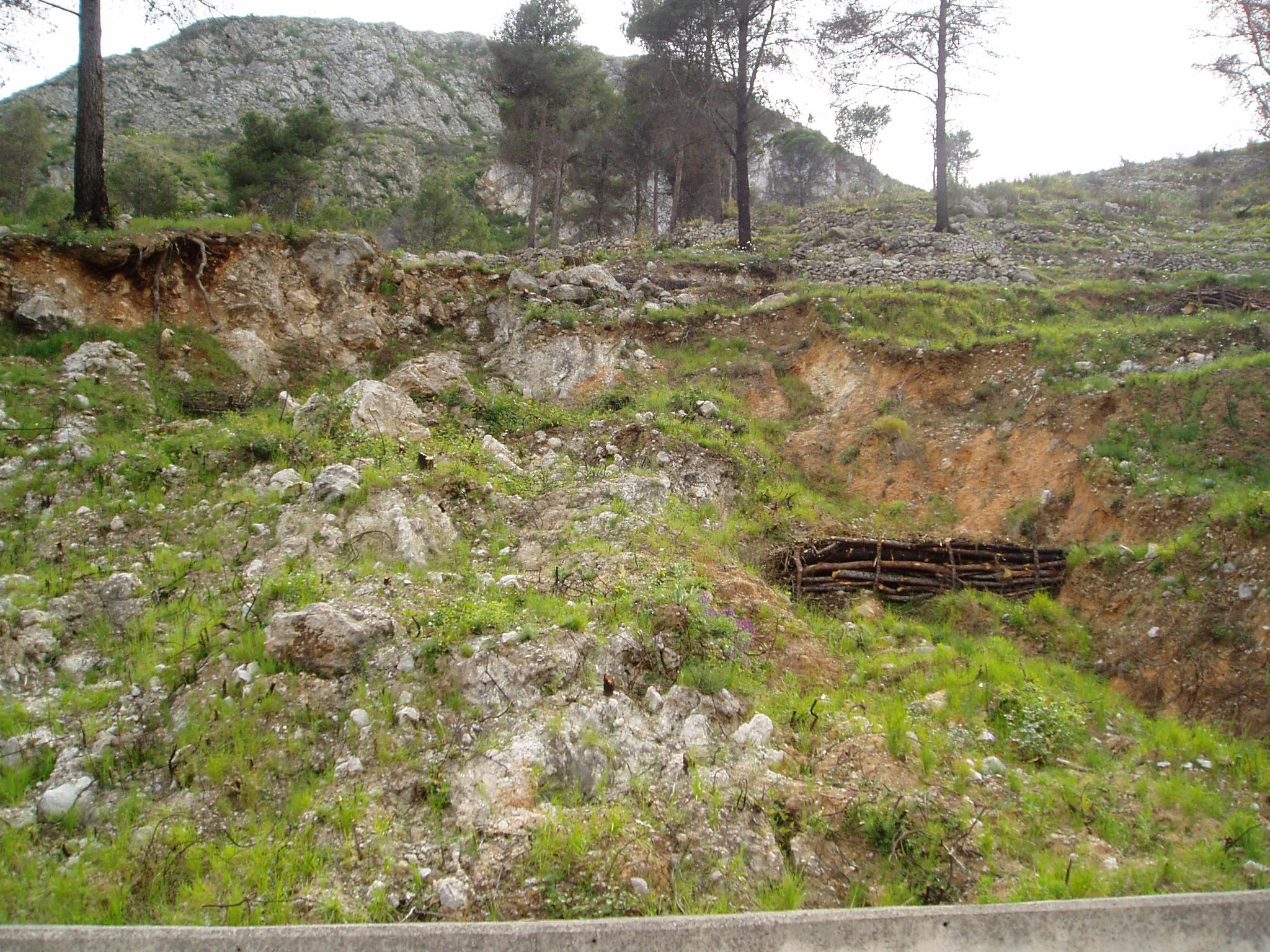
Description:
A foreseen wildfire is expected for the summer 2015 in the Caroig mountain range. Area was afforested by Aleppo pines during last XX century and nowadays landscape is composed by mature Aleppo pines at different stages of development and, the understory shrub vegetation.
The research team of the University of Valencia will implement an experiment based on the contour-felled log erosion barriers technique to capture and measure post-fire soil losses in a natural burned landscape
Purpose of the Technology: Contour-felled log erosion barriers are designed to increase detention and infiltration of overland flow, thereby reducing runoff and sediment transport capacity
Establishment / maintenance activities and inputs: The standard installation technique consists of felling burned trees and laying them on the ground along the slope contour. Each log is anchored in place and gaps between the log and the soil surface are filled with soil to create a storage basin on the upslope side of the log where overland flow is trapped
Natural / human environment: The Aleppo pine trees in the region are typically planted as monoculture for wood production. The landscape reflects a long history of intense land management, with a mosaic of (semi-)natural and man-made agricultural (terraces) and afforested lands. Since the 1970´s, however, wildfires have increased dramatically in frequency and extent, driven primarily by socio-economic changes.
2.3 Photos of the Technology
Media Gallery
2.5 Country/ region/ locations where the Technology has been applied and which are covered by this assessment
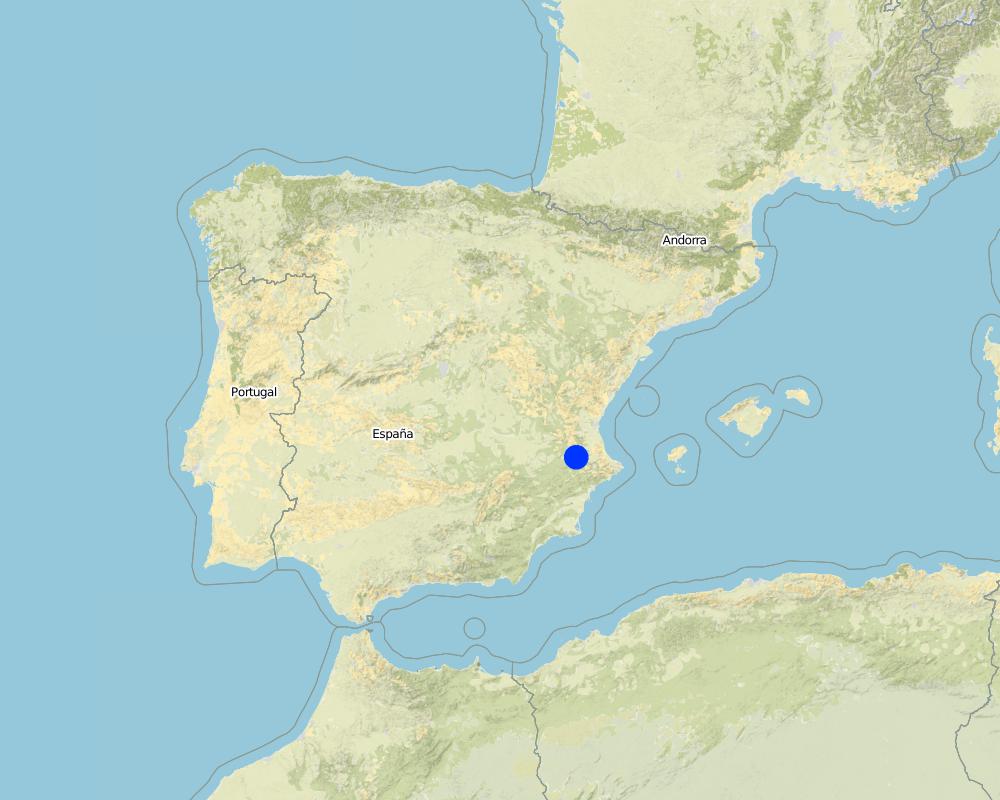
Country:
Spain
Region/ State/ Province:
Spain
Further specification of location:
Valencia
Map
×2.6 Date of implementation
If precise year is not known, indicate approximate date:
- 10-50 years ago
2.7 Introduction of the Technology
Specify how the Technology was introduced:
- during experiments/ research
3. Classification of the SLM Technology
3.1 Main purpose(s) of the Technology
- reduce, prevent, restore land degradation
3.2 Current land use type(s) where the Technology is applied

Forest/ woodlands
Tree plantation, afforestation:
- Monoculture local variety
- Aleppo pines
Products and services:
- Timber
- Fuelwood
- Fruits and nuts
- Other forest products
- Grazing/ browsing
- Nature conservation/ protection
- Recreation/ tourism
- Protection against natural hazards
Comments:
Major land use problems (compiler’s opinion): When high fire severity, it is expected a runoff and soil erosion increase, resulting in a decrease of on-site fertility and derived off-site effects such as loss of water quality, reservoirs water volume storage, higher risk of flooding and human beings damage.
Major land use problems (land users’ perception): Loss of wood resources.
Plantation forestry: Post-fire assessment
Forest products and services: Other forest products / uses (honey, medical, etc.)
3.3 Further information about land use
Specify:
Longest growing period in days: 180Longest growing period from month to month: February to June
3.4 SLM group to which the Technology belongs
- natural and semi-natural forest management
3.6 SLM measures comprising the Technology

structural measures
- S6: Walls, barriers, palisades, fences
Comments:
Main measures: structural measures
3.7 Main types of land degradation addressed by the Technology

soil erosion by water
- Wt: loss of topsoil/ surface erosion
Comments:
Main causes of degradation: soil management (monoculture plantations are prone to forest fires), deforestation / removal of natural vegetation (incl. forest fires) (Forest fires), population pressure (depopulation)
3.8 Prevention, reduction, or restoration of land degradation
Specify the goal of the Technology with regard to land degradation:
- reduce land degradation
Comments:
Main goals: mitigation / reduction of land degradation
4. Technical specifications, implementation activities, inputs, and costs
4.1 Technical drawing of the Technology
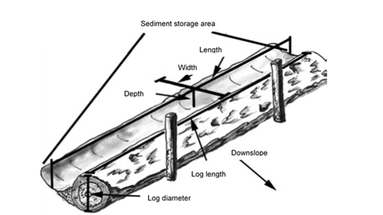
Author:
Gonzalez-Pelayo, Oscar, University of Valencia. Dept. of Geography. Blasco Ibañez 28, 46010. Valencia, Spain
4.2 Technical specifications/ explanations of technical drawing
Diagram of the contour felled log erosion barriers. Extracted from P. R. Robichaud, J. W. Wagenbrenner, R. E. Brown, P. M. Wohlgemuthand J. L. Beyers. 2008. Evaluating the effectiveness of contour-felled log erosion barriers as a post-fire runoff and erosion mitigation treatment in the western United States. International Journal of Wildland Fire, 17: 255-273.
Location: Valencia. Spain
Date: 06/05/2013
Technical knowledge required for field staff / advisors: high (Qualification is mandatory in order to choose landscape area to implement and how to do.)
Technical knowledge required for land users: moderate
Main technical functions: control of dispersed runoff: retain / trap, control of concentrated runoff: retain / trap, sediment retention / trapping, sediment harvesting
Construction material (wood): Partially burned logs are utilized for barriers contruction
5. Natural and human environment
5.1 Climate
Annual rainfall
- < 250 mm
- 251-500 mm
- 501-750 mm
- 751-1,000 mm
- 1,001-1,500 mm
- 1,501-2,000 mm
- 2,001-3,000 mm
- 3,001-4,000 mm
- > 4,000 mm
Specifications/ comments on rainfall:
Mediterranean climate with concentred precipitation from february-may and usual drought in summer period (june-september)
Agro-climatic zone
- sub-humid
- semi-arid
Thermal climate class: temperate (Transition zone between semi-arid and subhumid)
5.2 Topography
Slopes on average:
- flat (0-2%)
- gentle (3-5%)
- moderate (6-10%)
- rolling (11-15%)
- hilly (16-30%)
- steep (31-60%)
- very steep (>60%)
Landforms:
- plateau/plains
- ridges
- mountain slopes
- hill slopes
- footslopes
- valley floors
Altitudinal zone:
- 0-100 m a.s.l.
- 101-500 m a.s.l.
- 501-1,000 m a.s.l.
- 1,001-1,500 m a.s.l.
- 1,501-2,000 m a.s.l.
- 2,001-2,500 m a.s.l.
- 2,501-3,000 m a.s.l.
- 3,001-4,000 m a.s.l.
- > 4,000 m a.s.l.
Indicate if the Technology is specifically applied in:
- concave situations
Comments and further specifications on topography:
Slopes on average: Also steep (31-60%)
Landforms: Also footslopes
Altitudinal zone: 501-1000 m a.s.l. (650-700m)
5.3 Soils
Soil depth on average:
- very shallow (0-20 cm)
- shallow (21-50 cm)
- moderately deep (51-80 cm)
- deep (81-120 cm)
- very deep (> 120 cm)
Soil texture (topsoil):
- medium (loamy, silty)
Topsoil organic matter:
- high (>3%)
If available, attach full soil description or specify the available information, e.g. soil type, soil PH/ acidity, Cation Exchange Capacity, nitrogen, salinity etc.
Soil depth on average: Very shallow (Leptosol) and shallow (Cambisol)
Soil fertility is medium
Soil drainage/infiltration is medium
Soil water storage capacity is high
5.4 Water availability and quality
Ground water table:
5-50 m
Availability of surface water:
medium
Water quality (untreated):
for agricultural use only (irrigation)
5.5 Biodiversity
Species diversity:
- medium
5.7 Average area of land owned or leased by land users applying the Technology
- < 0.5 ha
- 0.5-1 ha
- 1-2 ha
- 2-5 ha
- 5-15 ha
- 15-50 ha
- 50-100 ha
- 100-500 ha
- 500-1,000 ha
- 1,000-10,000 ha
- > 10,000 ha
5.9 Access to services and infrastructure
health:
- poor
- moderate
- good
education:
- poor
- moderate
- good
technical assistance:
- poor
- moderate
- good
employment (e.g. off-farm):
- poor
- moderate
- good
markets:
- poor
- moderate
- good
energy:
- poor
- moderate
- good
roads and transport:
- poor
- moderate
- good
drinking water and sanitation:
- poor
- moderate
- good
financial services:
- poor
- moderate
- good
6. Impacts and concluding statements
6.1 On-site impacts the Technology has shown
Ecological impacts
Water cycle/ runoff
surface runoff
Soil
soil loss
6.2 Off-site impacts the Technology has shown
downstream flooding
6.3 Exposure and sensitivity of the Technology to gradual climate change and climate-related extremes/ disasters (as perceived by land users)
Climate-related extremes (disasters)
Meteorological disasters
| How does the Technology cope with it? | |
|---|---|
| local rainstorm | well |
6.7 Strengths/ advantages/ opportunities of the Technology
| Strengths/ advantages/ opportunities in the compiler’s or other key resource person’s view |
|---|
| Contour felled log erosion barriers in a post-fire environment reduce soil erosion and off-site effects. |
Links and modules
Expand all Collapse allLinks
No links
Modules
No modules