Contour Bunding [Nepal]
- Creation:
- Update:
- Compiler: Shreedip Sigdel
- Editor: –
- Reviewers: David Streiff, Alexandra Gavilano
Bhajo Rakhne (Main Contributor: Bir Bahadur Tamang, LI-BIRD)
technologies_1683 - Nepal
View sections
Expand all Collapse all1. General information
1.2 Contact details of resource persons and institutions involved in the assessment and documentation of the Technology
SLM specialist:
Tamang Bir Bahadur
LI-BIRD
Nepal
Name of the institution(s) which facilitated the documentation/ evaluation of the Technology (if relevant)
Local Initiatives for Biodiversity, Research, and Development (LI-BIRD) - NepalName of the institution(s) which facilitated the documentation/ evaluation of the Technology (if relevant)
ICIMOD International Centre for Integrated Mountain Development (ICIMOD) - Nepal1.3 Conditions regarding the use of data documented through WOCAT
The compiler and key resource person(s) accept the conditions regarding the use of data documented through WOCAT:
Yes
2. Description of the SLM Technology
2.1 Short description of the Technology
Definition of the Technology:
A traditional low-cost method of soil conservation suitable for sloping land; it promotes water retention and helps prevent erosion.
2.2 Detailed description of the Technology
Description:
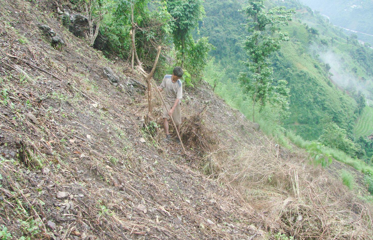
Contour bunding is a proven sustainable land management practice for marginal, sloping, and hilly land where the soil productivity is very low. It is widely adopted by the ethnic minorities of Nepal who practice the shifting cultivation system of farming. Over generations, they have successfully used this technology to control soil erosion, promote water retention, and increase crop production. It has a high probability of replication because it is simple to implement, is low cost, and makes the maximum use of local resources.
Purpose of the Technology: Farmers use a multi-step process to promote the formation of rough terraces along contour lines on sloping land. First the vegetation on the shifting cultivation plot (mostly fodder and forage trees and bushes) is cut down and the leaves and small twigs removed from the branches by slashing. All the material is left on the surface to dry. The leaves and twigs gradually decompose. After a few weeks, the remaining dry material is rolled into bundles and arranged along contour lines. The material is anchored with pegs, stones, and (where possible) tree stumps. This is the beginning of the contour bund. The farmers then incorporate the remaining leaf litter and decomposed organic matter into the soil between the bunds and plant crops. Over time, as the soil gradually deposits above each bund and is eroded below, rough terraces are formed. The process is labour intensive and farmers need to regularly check and maintain the bunds to allow the soil to collect.
Establishment / maintenance activities and inputs: Contour bunding is relatively easy to establish and maintain since it does not require external inputs and local unskilled labourers can make them using locally available woody materials. It is also both sustainable and ecofriendly since there are no external inputs and no organic matter is burned in the process.
The use of contour bunding is limited by the fact that it is labour intensive and that bunding cannot be implemented during the fallow period of the shifting cultivation cycle, thus it can only be applied on a plot for two years (the cultivation period of the shifting cultivation cycle).
2.3 Photos of the Technology
Media Gallery

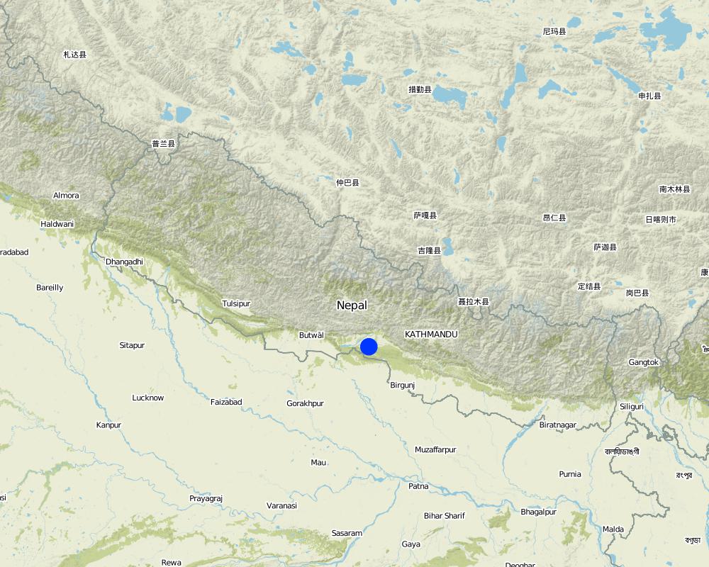
2.5 Country/ region/ locations where the Technology has been applied and which are covered by this assessment
Country:
Nepal
Further specification of location:
Chitwan, Tanahu, Gorkha, Dhading and Makawanpur
Specify the spread of the Technology:
- evenly spread over an area
If precise area is not known, indicate approximate area covered:
- 1-10 km2
Map
×2.6 Date of implementation
If precise year is not known, indicate approximate date:
- more than 50 years ago (traditional)
2.7 Introduction of the Technology
Specify how the Technology was introduced:
- as part of a traditional system (> 50 years)
3. Classification of the SLM Technology
3.1 Main purpose(s) of the Technology
- improve production
- reduce, prevent, restore land degradation
3.2 Current land use type(s) where the Technology is applied

Cropland
- Annual cropping
Number of growing seasons per year:
- 2
Comments:
Major land use problems (compiler’s opinion): Shifting cultivation is a traditional farming system practice used by the ethnic minorities who farm marginal, hilly, and sloping land. Erratic rainfall and improper land use practices all contribute to land Rock phosphate is not always available -> crushed stone dust can be substituted. degradation.
Livestock is grazing on crop residues
3.4 Water supply
Water supply for the land on which the Technology is applied:
- rainfed
3.5 SLM group to which the Technology belongs
- improved ground/ vegetation cover
- cross-slope measure
3.6 SLM measures comprising the Technology

structural measures
- S1: Terraces
3.7 Main types of land degradation addressed by the Technology

soil erosion by water
- Wt: loss of topsoil/ surface erosion
Comments:
Main causes of degradation: over-exploitation of vegetation for domestic use, Heavy / extreme rainfall (intensity/amounts) (Natural soil Erosion), population pressure
3.8 Prevention, reduction, or restoration of land degradation
Specify the goal of the Technology with regard to land degradation:
- reduce land degradation
4. Technical specifications, implementation activities, inputs, and costs
4.1 Technical drawing of the Technology
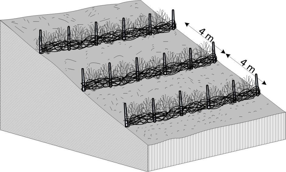
Technical specifications (related to technical drawing):
Contour bunding on sloping land; after leafy matter is slashed and allowed to dry it is gathered into bunds and anchored into place using locally available materials such as twigs and stones; note that the bunds are typically spaced about 4 m apart.
Technical knowledge required for land users: moderate
Main technical functions: control of dispersed runoff: retain / trap
Secondary technical functions: increase in organic matter, increase / maintain water stored in soil
Author:
BB Tamang and AK Thaku
4.2 General information regarding the calculation of inputs and costs
Specify how costs and inputs were calculated:
- per Technology area
Indicate size and area unit:
ha
Specify currency used for cost calculations:
- USD
Indicate average wage cost of hired labour per day:
2.70
4.3 Establishment activities
| Activity | Timing (season) | |
|---|---|---|
| 1. | The vegetation on the plots (leafy fodder and others) is slashed and allowed to dry on the sloping land.The dry materials are collected along contour lines and anchored into place using locally available materials.The land between the bund lines is enriched with the leaf litter and crops are planted. | few weeks (16 days) |
4.4 Costs and inputs needed for establishment
| Specify input | Unit | Quantity | Costs per Unit | Total costs per input | % of costs borne by land users | |
|---|---|---|---|---|---|---|
| Labour | Building rough terraces | persons/day/ha | 16.0 | 2.7 | 43.2 | 100.0 |
| Total costs for establishment of the Technology | 43.2 | |||||
| Total costs for establishment of the Technology in USD | 43.2 | |||||
4.5 Maintenance/ recurrent activities
| Activity | Timing/ frequency | |
|---|---|---|
| 1. | The bundling is periodically checked and lapsed areas are repaired as needed | few days |
4.6 Costs and inputs needed for maintenance/ recurrent activities (per year)
| Specify input | Unit | Quantity | Costs per Unit | Total costs per input | % of costs borne by land users | |
|---|---|---|---|---|---|---|
| Labour | Maintaining area | persons/day/ha | 4.0 | 2.7 | 10.8 | 100.0 |
| Total costs for maintenance of the Technology | 10.8 | |||||
| Total costs for maintenance of the Technology in USD | 10.8 | |||||
4.7 Most important factors affecting the costs
Describe the most determinate factors affecting the costs:
The cost of implementing this technology is dependent on the gradient of the slope (and other geographical features) and the availability of labour. All costs and amounts are rough estimates by the technicians and authors.
5. Natural and human environment
5.1 Climate
Annual rainfall
- < 250 mm
- 251-500 mm
- 501-750 mm
- 751-1,000 mm
- 1,001-1,500 mm
- 1,501-2,000 mm
- 2,001-3,000 mm
- 3,001-4,000 mm
- > 4,000 mm
Agro-climatic zone
- sub-humid
Thermal climate class: subtropics
5.2 Topography
Slopes on average:
- flat (0-2%)
- gentle (3-5%)
- moderate (6-10%)
- rolling (11-15%)
- hilly (16-30%)
- steep (31-60%)
- very steep (>60%)
Landforms:
- plateau/plains
- ridges
- mountain slopes
- hill slopes
- footslopes
- valley floors
Altitudinal zone:
- 0-100 m a.s.l.
- 101-500 m a.s.l.
- 501-1,000 m a.s.l.
- 1,001-1,500 m a.s.l.
- 1,501-2,000 m a.s.l.
- 2,001-2,500 m a.s.l.
- 2,501-3,000 m a.s.l.
- 3,001-4,000 m a.s.l.
- > 4,000 m a.s.l.
5.3 Soils
Soil depth on average:
- very shallow (0-20 cm)
- shallow (21-50 cm)
- moderately deep (51-80 cm)
- deep (81-120 cm)
- very deep (> 120 cm)
Soil texture (topsoil):
- coarse/ light (sandy)
Topsoil organic matter:
- medium (1-3%)
If available, attach full soil description or specify the available information, e.g. soil type, soil PH/ acidity, Cation Exchange Capacity, nitrogen, salinity etc.
Soil fertility is low
Soil water storage capacity is very low
5.4 Water availability and quality
Ground water table:
> 50 m
Availability of surface water:
poor/ none
5.6 Characteristics of land users applying the Technology
Market orientation of production system:
- subsistence (self-supply)
Off-farm income:
- 10-50% of all income
Relative level of wealth:
- poor
Individuals or groups:
- individual/ household
Level of mechanization:
- manual work
Indicate other relevant characteristics of the land users:
Land users applying the Technology are mainly disadvantaged land users
Population density: 10-50 persons/km2
Annual population growth: 2% - 3%
5.7 Average area of land used by land users applying the Technology
- < 0.5 ha
- 0.5-1 ha
- 1-2 ha
- 2-5 ha
- 5-15 ha
- 15-50 ha
- 50-100 ha
- 100-500 ha
- 500-1,000 ha
- 1,000-10,000 ha
- > 10,000 ha
Is this considered small-, medium- or large-scale (referring to local context)?
- small-scale
5.8 Land ownership, land use rights, and water use rights
Land ownership:
- individual, not titled
Land use rights:
- individual
Water use rights:
- open access (unorganized)
5.9 Access to services and infrastructure
health:
- poor
- moderate
- good
education:
- poor
- moderate
- good
technical assistance:
- poor
- moderate
- good
employment (e.g. off-farm):
- poor
- moderate
- good
markets:
- poor
- moderate
- good
energy:
- poor
- moderate
- good
roads and transport:
- poor
- moderate
- good
drinking water and sanitation:
- poor
- moderate
- good
financial services:
- poor
- moderate
- good
6. Impacts and concluding statements
6.1 On-site impacts the Technology has shown
Socio-economic impacts
Production
crop production
wood production
product diversity
land management
Income and costs
expenses on agricultural inputs
farm income
diversity of income sources
workload
Socio-cultural impacts
food security/ self-sufficiency
health situation
community institutions
SLM/ land degradation knowledge
conflict mitigation
livelihood and human well-being
Comments/ specify:
increased crop production, with associated increase in income and improved human health
Ecological impacts
Soil
soil moisture
soil cover
soil loss
nutrient cycling/ recharge
soil organic matter/ below ground C
Biodiversity: vegetation, animals
pest/ disease control
Comments/ specify:
birds, slugs, rodents
Other ecological impacts
Competition
Comments/ specify:
of water, sunlight and nutrients
habitat fragmentation
6.2 Off-site impacts the Technology has shown
downstream flooding
downstream siltation
buffering/ filtering capacity
wind transported sediments
6.3 Exposure and sensitivity of the Technology to gradual climate change and climate-related extremes/ disasters (as perceived by land users)
Gradual climate change
Gradual climate change
| Season | increase or decrease | How does the Technology cope with it? | |
|---|---|---|---|
| annual temperature | increase | well |
Climate-related extremes (disasters)
Climatological disasters
| How does the Technology cope with it? | |
|---|---|
| drought | well |
6.4 Cost-benefit analysis
How do the benefits compare with the establishment costs (from land users’ perspective)?
Short-term returns:
slightly positive
Long-term returns:
positive
How do the benefits compare with the maintenance/ recurrent costs (from land users' perspective)?
Short-term returns:
positive
Long-term returns:
very positive
6.5 Adoption of the Technology
- > 50%
If available, quantify (no. of households and/ or area covered):
200 households in an area of 1 - 10 sq km (10 - 50 persons/sq km)
Of all those who have adopted the Technology, how many did so spontaneously, i.e. without receiving any material incentives/ payments?
- 91-100%
Comments:
There is a moderate trend towards spontaneous adoption of the Technology
Comments on adoption trend: About 200 land user families have voluntarily adopted this technology in Tanahun, Chitawan, Gorkha, Dhading, and Makawanpur Districts of Nepal.
6.7 Strengths/ advantages/ opportunities of the Technology
| Strengths/ advantages/ opportunities in the compiler’s or other key resource person’s view |
|---|
|
Decreased soil erosion and increased productivity of the soil How can they be sustained / enhanced? Formation of permanent bunds and terraces; adds organic matter to the soil |
|
Natural terrace formation and decreasing slope gradient How can they be sustained / enhanced? Over time, as more soil deposits on the bunds, the gradient is naturally decreased |
|
As the organic matter content increases, humus soil is formed and the soil fertility increases How can they be sustained / enhanced? Continue to accumulate crop residues on the surface; these will decompose and increase the organic matter content of the soil |
6.8 Weaknesses/ disadvantages/ risks of the Technology and ways of overcoming them
| Weaknesses/ disadvantages/ risks in the compiler’s or other key resource person’s view | How can they be overcome? |
|---|---|
| Slashing contributes to the risk of forest fires | After drying, the slashed materials should be rolled out within a week |
| When too many trees are slashed it can promote landslides | Grow trees along the bunds; fodder trees are especially beneficial |
| Bunds may harbour biological pests such as rodents | Regular maintenance and pest control can help to limit unwanted wildlife |
7. References and links
7.1 Methods/ sources of information
7.2 References to available publications
Title, author, year, ISBN:
Indigenous knowledge of farmers in the shifting cultivation areas of Western Nepal., Regmi, BR; Aryal, KP; Subedi, A; Shrestha, PK; Tamang, BB, 2001
Links and modules
Expand all Collapse allLinks
No links
Modules
No modules