Almond and Apple sapling plantation [Iran, Islamic Republic of]
- Creation:
- Update:
- Compiler: Unknown User
- Editor: –
- Reviewers: David Streiff, Alexandra Gavilano
تبدیل دیمزارهای کم بازده (گندم و جو) به باغات سیب و بادام (arab)
technologies_1742 - Iran, Islamic Republic of
View sections
Expand all Collapse all1. General information
1.2 Contact details of resource persons and institutions involved in the assessment and documentation of the Technology
Key resource person(s)
SLM specialist:
Majid Soufi
SLM specialist:
Hasan Ahmadi Shiraz
1.3 Conditions regarding the use of data documented through WOCAT
The compiler and key resource person(s) accept the conditions regarding the use of data documented through WOCAT:
Yes
2. Description of the SLM Technology
2.1 Short description of the Technology
Definition of the Technology:
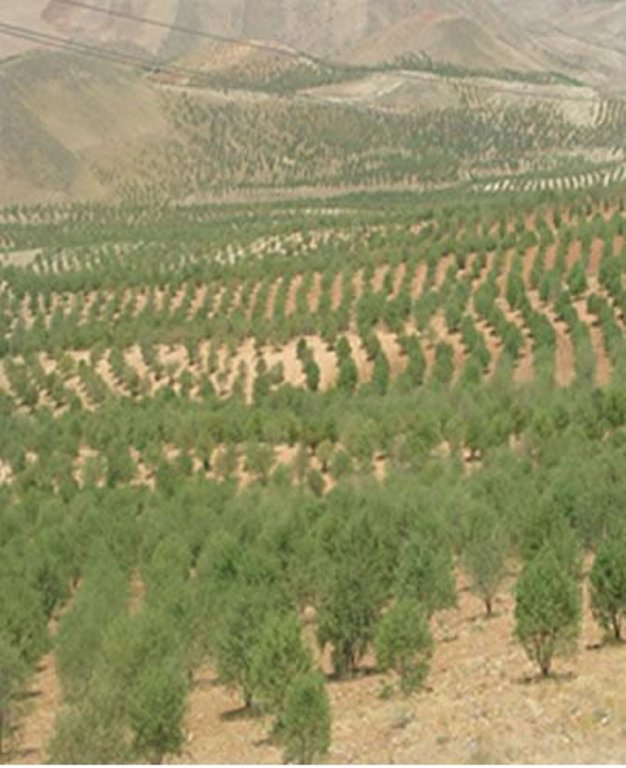
Plantation of almond and apple trees on the contour lines instead of annual rainfed crops such as wheat and barley on hills with 8 to 30% slope.
2.2 Detailed description of the Technology
Description:
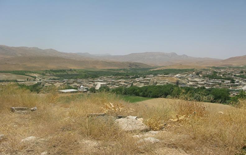
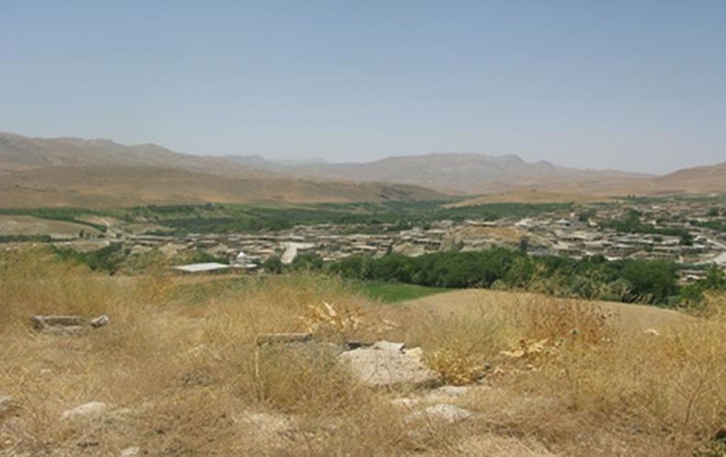
Dejkord village is located in north – west of Fars province and west of Eghlid dis-trict. This village is located on hilly steep land with 390 families. Climate of the village, according to Demarton classification, is situated in the Mediterranean temperate zone. The long-term mean annual temperature is 13.5ºc and long-term mean annual rainfall is 510 mm. The landforms of the study area are generally rolling (with slope 8-16%) and medium mountain ridges (with slope 16-30%). The site study is located between 2000 and 2700m above sea level. The average depth of the soil in this region is 50cm. Dominant top soil textures are sandy loam, loam, and sandy clay loam and are commonly shallow with low amounts of organic matter (usually below1% ). The results of soil analysis showed that silt decreases and sand and clay increase with soil depth. The range of clay, silt, and sand is respectively 16 to 35 %, 9 to 33 %, and 47 to 73%. EC (Soil Electrical con-ductivity) is less than 1(dS/m). The main problems in this area are poverty and soil erosion that reduce crops yield. Ploughing in slope aspect increased soil erosion in this area.
The impact of this technology depends on establish pits on contour line that caused to keep runoff and reduce velocity of rain water and also canopy cover of trees caused to prevent of rain splash and provides adequate soil cover, protect-ing the land from Erosion and roots of trees enhanced infiltration. Otherwise this system increased farmer income rather than before implementation technology.
Watershed Cooperative of Dejkord started its activities since 1998 with 548 mem-ber and covering 8 villages but today this watershed cooperative have 8000 members . In order to build capacity for the watershed resident, the Fars province office of natural resource started to give lands for non – irrigated plantation which are suitable for improving the watershed. The mentioned office gives US$ 800 loan as a very cheap facility against 1 hectare of the land to the members of watershed cooperative, and the time of paying back is 5 years after they get the loan. Nowadays 15000 hectares of those lands are converted to non – irrigated gardens of Almond and Apple trees. Out of 15000 hectares, 10000 include productive Almond garden, and 5000 hectares include Apple garden .As an average, for 1 hectare about 4.5 to 5 kg seed with the value of 1.5 US$ are needed. There are 270 to 300 saplings in 1 hectare and the distance between the saplings is 6 meter. Before the watershed program, the income of resident was US$ 80 per hectare per year, however after the project their income increased to US$ 1000 to 1200.per hectare per year. For maintenance of the project some measure like fertilizing, recession, spraying, cropping and etc will be done.
2.3 Photos of the Technology
2.5 Country/ region/ locations where the Technology has been applied and which are covered by this assessment
Country:
Iran, Islamic Republic of
Region/ State/ Province:
Fars Province, Iran
Further specification of location:
Eghlid District, Dejkord Village
Comments:
Total area covered by the SLM Technology is 150 km2.
2.6 Date of implementation
Indicate year of implementation:
1998
If precise year is not known, indicate approximate date:
- 10-50 years ago
2.7 Introduction of the Technology
Specify how the Technology was introduced:
- during experiments/ research
3. Classification of the SLM Technology
3.1 Main purpose(s) of the Technology
- reduce, prevent, restore land degradation
- create beneficial economic impact
3.2 Current land use type(s) where the Technology is applied
Land use mixed within the same land unit:
Yes
Specify mixed land use (crops/ grazing/ trees):
- Agroforestry

Cropland
- Annual cropping
- Tree and shrub cropping
Annual cropping - Specify crops:
- cereals - barley
- wheat
Tree and shrub cropping - Specify crops:
- pome fruits (apples, pears, quinces, etc.)
- tree nuts (brazil nuts, pistachio, walnuts, almonds, etc.)
Comments:
Major land use problems (compiler’s opinion): There are several problems in this area, including: land degradation because of inter-rill, rill and gully erosion, lack of income economic resources for stockholders before implementation. income of resident was US$ 80 per hectare per year from annual crops but after the implementation, their income increased to US$ 1000 to 1200, plowing the lands by farmers along with slope in land with more than 10% slope topographical status, soil fertility decline.
Future (final) land use (after implementation of SLM Technology): Cropland: Ct: Tree and shrub cropping
3.3 Has land use changed due to the implementation of the Technology?
Has land use changed due to the implementation of the Technology?
- Yes (Please fill out the questions below with regard to the land use before implementation of the Technology)

Cropland
- Annual cropping
3.4 Water supply
Water supply for the land on which the Technology is applied:
- rainfed
3.5 SLM group to which the Technology belongs
- improved ground/ vegetation cover
- cross-slope measure
3.6 SLM measures comprising the Technology

vegetative measures
- V1: Tree and shrub cover

management measures
- M1: Change of land use type
3.7 Main types of land degradation addressed by the Technology

soil erosion by water
- Wt: loss of topsoil/ surface erosion
- Wg: gully erosion/ gullying

chemical soil deterioration
- Cn: fertility decline and reduced organic matter content (not caused by erosion)

biological degradation
- Bc: reduction of vegetation cover

water degradation
- Hq: decline of groundwater quality
Comments:
Main causes of degradation: soil management, deforestation / removal of natural vegetation (incl. forest fires), over-exploitation of vegetation for domestic use, overgrazing, industrial activities and mining, Heavy / extreme rainfall (intensity/amounts), floods, population pressure, poverty / wealth, education, access to knowledge and support services
3.8 Prevention, reduction, or restoration of land degradation
Specify the goal of the Technology with regard to land degradation:
- restore/ rehabilitate severely degraded land
4. Technical specifications, implementation activities, inputs, and costs
4.1 Technical drawing of the Technology
Technical specifications (related to technical drawing):
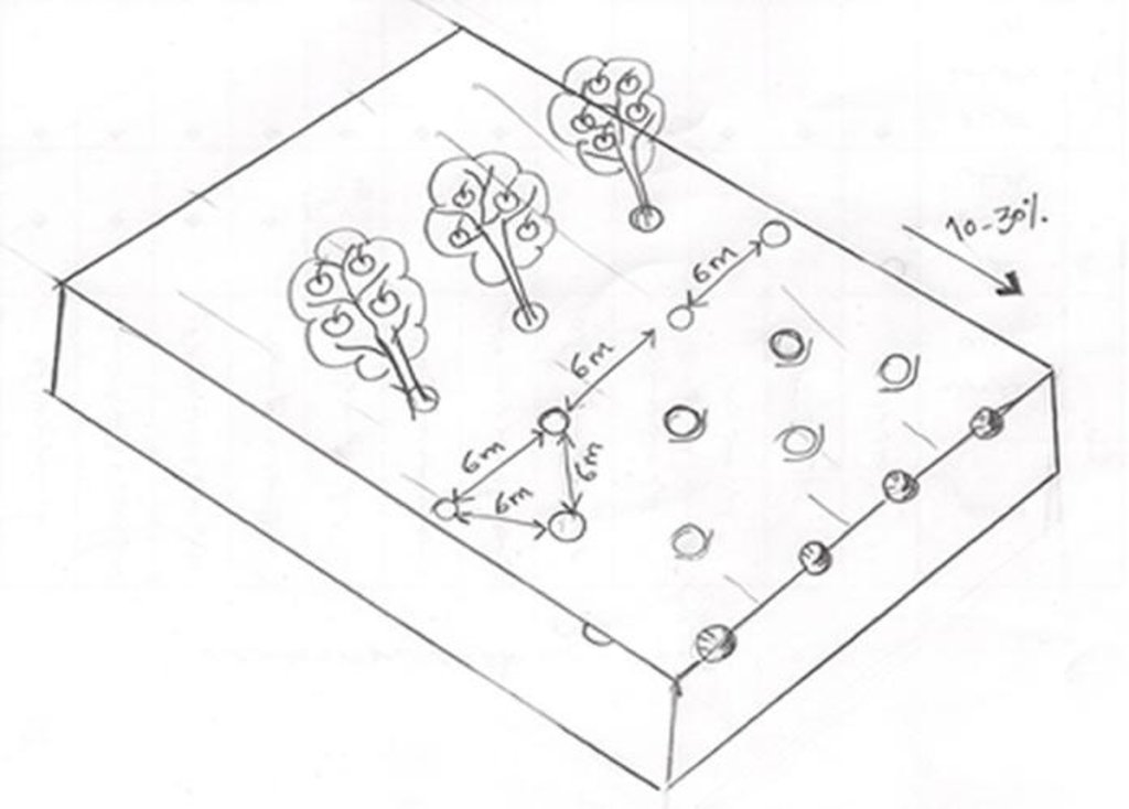
Fruit trees cultivated on slope (10 - 30%) with a spacing of 6 between.
Location: Dejkord Village. Eghlid District, Fars Province, Iran
Technical knowledge required for field staff / advisors: low
Technical knowledge required for land users: low
Main technical functions: improvement of ground cover, increase of surface roughness, increase in organic matter, increase of infiltration, increase in soil fertility
Secondary technical functions: control of raindrop splash, control of dispersed runoff: retain / trap, control of concentrated runoff: retain / trap, increase of groundwater level / recharge of groundwater, improvement of water quality, buffering / filtering water
Vegetative measure: Vegetative Measure
Vegetative material: F : fruit trees / shrubs
Vegetative measure: Vegetative material: F : fruit trees / shrubs
Change of land use type: Change from grazing land and annual rainfed crops to tree crops.
Author:
Maryam Rahimi
4.2 General information regarding the calculation of inputs and costs
Specify currency used for cost calculations:
- USD
4.3 Establishment activities
| Activity | Timing (season) | |
|---|---|---|
| 1. | Digging Pits carried out by labor on hilly steep land (approximately 270-300 pits per ha) | before rainy season |
| 2. | Planting of fruit tree seeds (Almond and Apple) by hand | spring |
4.4 Costs and inputs needed for establishment
| Specify input | Unit | Quantity | Costs per Unit | Total costs per input | % of costs borne by land users | |
|---|---|---|---|---|---|---|
| Labour | Digging Pits and planting of fruit trees | ha | 1.0 | 90.0 | 90.0 | 100.0 |
| Equipment | Machine use | ha | 1.0 | 40.0 | 40.0 | 100.0 |
| Plant material | Seeds | ha | 1.0 | 7.5 | 7.5 | 100.0 |
| Total costs for establishment of the Technology | 137.5 | |||||
| Total costs for establishment of the Technology in USD | 137.5 | |||||
4.5 Maintenance/ recurrent activities
| Activity | Timing/ frequency | |
|---|---|---|
| 1. | Plugging of land with tractor in contrast to the slope. | |
| 2. | Digging pits at the foot of the tree for water harvesting. | |
| 3. | Pest management with chemicals. | two or three times a year |
| 4. | Trees pruning. | every year |
| 5. | Create a slot for fertilizers/manuring | |
| 6. | Manuring. | after one year |
| 7. | Irrigation of new seedlings. | |
| 8. | Harversting of fruits. | |
| 9. | Pest control for trees and their fruits. |
4.6 Costs and inputs needed for maintenance/ recurrent activities (per year)
| Specify input | Unit | Quantity | Costs per Unit | Total costs per input | % of costs borne by land users | |
|---|---|---|---|---|---|---|
| Labour | All the labour | ha | 1.0 | 410.0 | 410.0 | 100.0 |
| Equipment | Machine use | ha | 1.0 | 45.0 | 45.0 | |
| Fertilizers and biocides | Compost/manure | ha | 1.0 | 70.0 | 70.0 | 100.0 |
| Fertilizers and biocides | Toxin for pets | ha | 1.0 | 45.0 | 45.0 | 100.0 |
| Total costs for maintenance of the Technology | 570.0 | |||||
| Total costs for maintenance of the Technology in USD | 570.0 | |||||
5. Natural and human environment
5.1 Climate
Annual rainfall
- < 250 mm
- 251-500 mm
- 501-750 mm
- 751-1,000 mm
- 1,001-1,500 mm
- 1,501-2,000 mm
- 2,001-3,000 mm
- 3,001-4,000 mm
- > 4,000 mm
Agro-climatic zone
- semi-arid
Thermal climate class: temperate. Mediterranean
5.2 Topography
Slopes on average:
- flat (0-2%)
- gentle (3-5%)
- moderate (6-10%)
- rolling (11-15%)
- hilly (16-30%)
- steep (31-60%)
- very steep (>60%)
Landforms:
- plateau/plains
- ridges
- mountain slopes
- hill slopes
- footslopes
- valley floors
Altitudinal zone:
- 0-100 m a.s.l.
- 101-500 m a.s.l.
- 501-1,000 m a.s.l.
- 1,001-1,500 m a.s.l.
- 1,501-2,000 m a.s.l.
- 2,001-2,500 m a.s.l.
- 2,501-3,000 m a.s.l.
- 3,001-4,000 m a.s.l.
- > 4,000 m a.s.l.
5.3 Soils
Soil depth on average:
- very shallow (0-20 cm)
- shallow (21-50 cm)
- moderately deep (51-80 cm)
- deep (81-120 cm)
- very deep (> 120 cm)
Soil texture (topsoil):
- coarse/ light (sandy)
- medium (loamy, silty)
Topsoil organic matter:
- low (<1%)
If available, attach full soil description or specify the available information, e.g. soil type, soil PH/ acidity, Cation Exchange Capacity, nitrogen, salinity etc.
Soil fertility is medium
Soil drainage / infiltration is medium
Soil water storage capacity is low
5.4 Water availability and quality
Ground water table:
on surface
Availability of surface water:
excess
Water quality (untreated):
good drinking water
Comments and further specifications on water quality and quantity:
Ground water table: Near ground
5.5 Biodiversity
Species diversity:
- low
Comments and further specifications on biodiversity:
There were many wild birds before, now there are only few.
5.6 Characteristics of land users applying the Technology
Market orientation of production system:
- mixed (subsistence/ commercial)
Off-farm income:
- less than 10% of all income
Relative level of wealth:
- poor
Individuals or groups:
- cooperative
Level of mechanization:
- manual work
Indicate other relevant characteristics of the land users:
Off-farm income specification: Most farmers depend economically entirely on their own crop production.
5.7 Average area of land used by land users applying the Technology
- < 0.5 ha
- 0.5-1 ha
- 1-2 ha
- 2-5 ha
- 5-15 ha
- 15-50 ha
- 50-100 ha
- 100-500 ha
- 500-1,000 ha
- 1,000-10,000 ha
- > 10,000 ha
Is this considered small-, medium- or large-scale (referring to local context)?
- small-scale
5.8 Land ownership, land use rights, and water use rights
Land ownership:
- individual, titled
Land use rights:
- communal (organized)
Water use rights:
- communal (organized)
6. Impacts and concluding statements
6.1 On-site impacts the Technology has shown
Socio-economic impacts
Production
wood production
risk of production failure
product diversity
production area
Water availability and quality
drinking water availability
irrigation water availability
irrigation water quality
Income and costs
expenses on agricultural inputs
farm income
Socio-cultural impacts
food security/ self-sufficiency
cultural opportunities
recreational opportunities
community institutions
national institutions
SLM/ land degradation knowledge
situation of socially and economically disadvantaged groups
livelihood and human well-being
Ecological impacts
Water cycle/ runoff
water quantity
water quality
surface runoff
excess water drainage
evaporation
Soil
soil moisture
soil cover
soil loss
nutrient cycling/ recharge
soil organic matter/ below ground C
Biodiversity: vegetation, animals
biomass/ above ground C
plant diversity
pest/ disease control
Climate and disaster risk reduction
flood impacts
wind velocity
Other ecological impacts
competition
6.2 Off-site impacts the Technology has shown
downstream flooding
groundwater/ river pollution
wind transported sediments
damage on neighbours' fields
wind velocity
6.4 Cost-benefit analysis
How do the benefits compare with the establishment costs (from land users’ perspective)?
Short-term returns:
positive
Long-term returns:
very positive
How do the benefits compare with the maintenance/ recurrent costs (from land users' perspective)?
Short-term returns:
positive
Long-term returns:
very positive
Comments:
Establishment costs are high in the first year, but after 5 years the system becomes very profitable.
6.5 Adoption of the Technology
Comments:
Comments on adoption trend: At the first stage most of the land users who accepted the technology did so with incentives, but there was no spontaneous adoption.
- The project gives educational assistance, training, technical assistance in the field.
- Spontaneous adoption is growing in neighboring villages.
6.7 Strengths/ advantages/ opportunities of the Technology
| Strengths/ advantages/ opportunities in the land user’s view |
|---|
|
Different fruit harvested at different periods How can they be sustained / enhanced? gives better income in 1 year and therefore encourage family members participation |
|
Improved conservation/ erosion knowledge How can they be sustained / enhanced? This project has caused the resident acceptance and therefore caused to the extension of the technologies to the neighbor region |
| Strengths/ advantages/ opportunities in the compiler’s or other key resource person’s view |
|---|
|
Rehabilitation of degraded areas How can they be sustained / enhanced? reduced soil erosion and increased productivity |
|
Production increase and good fruit yields How can they be sustained / enhanced? Introduce low input demanding and fast producing tree species and varieties. |
|
Increased food security How can they be sustained / enhanced? with production and generation of different kind of fruits |
|
Reduction of erosion processes How can they be sustained / enhanced? Improve the soil cover through implementation of planted trees |
|
Increased crop production and diversity (fruit, timber) How can they be sustained / enhanced? Apple and Almond |
6.8 Weaknesses/ disadvantages/ risks of the Technology and ways of overcoming them
| Weaknesses/ disadvantages/ risks in the compiler’s or other key resource person’s view | How can they be overcome? |
|---|---|
| Fruit trees consume more water (but they also help in drainage) these trees with consuming water and waste it to transpiration caused to Reduction in stream flow in downstream | through lowering the ground water table. Appropriate tree species need to be selected and bred. |
| Pest and diseases | pests on apples reduced the price of products (pets controlled by toxin and natural hunters). |
7. References and links
7.1 Methods/ sources of information
Links and modules
Expand all Collapse allLinks
No links
Modules
No modules


