Controlling invasive species by physical removal and crop cultivation through open fallow irrigation [Kenya]
- Creation:
- Update:
- Compiler: Beatrice Otieno
- Editors: Urs Baumgartner, Christian Hergarten
- Reviewers: Rima Mekdaschi Studer, Rene Eschen
Cut, Burn, Uproot and Cultivate
technologies_3444 - Kenya
View sections
Expand all Collapse all1. General information
1.2 Contact details of resource persons and institutions involved in the assessment and documentation of the Technology
1.3 Conditions regarding the use of data documented through WOCAT
When were the data compiled (in the field)?
14/03/2018
The compiler and key resource person(s) accept the conditions regarding the use of data documented through WOCAT:
Yes
1.4 Declaration on sustainability of the described Technology
Is the Technology described here problematic with regard to land degradation, so that it cannot be declared a sustainable land management technology?
No
Comments:
Cultivation through irrigation in Perkerra scheme begun in 1954, three decades before the introduction of Prosopis in Baringo. Despite the rapid and widespread expansion of the invasive species, it is evident that cultivated areas under the scheme are free from Prosopis, unlike their surrounding neighborhoods which are heavily invaded and rendered unproductive. This is an indication of its sustainability to control Prosopis spread to irrigated land.
2. Description of the SLM Technology
2.1 Short description of the Technology
Definition of the Technology:
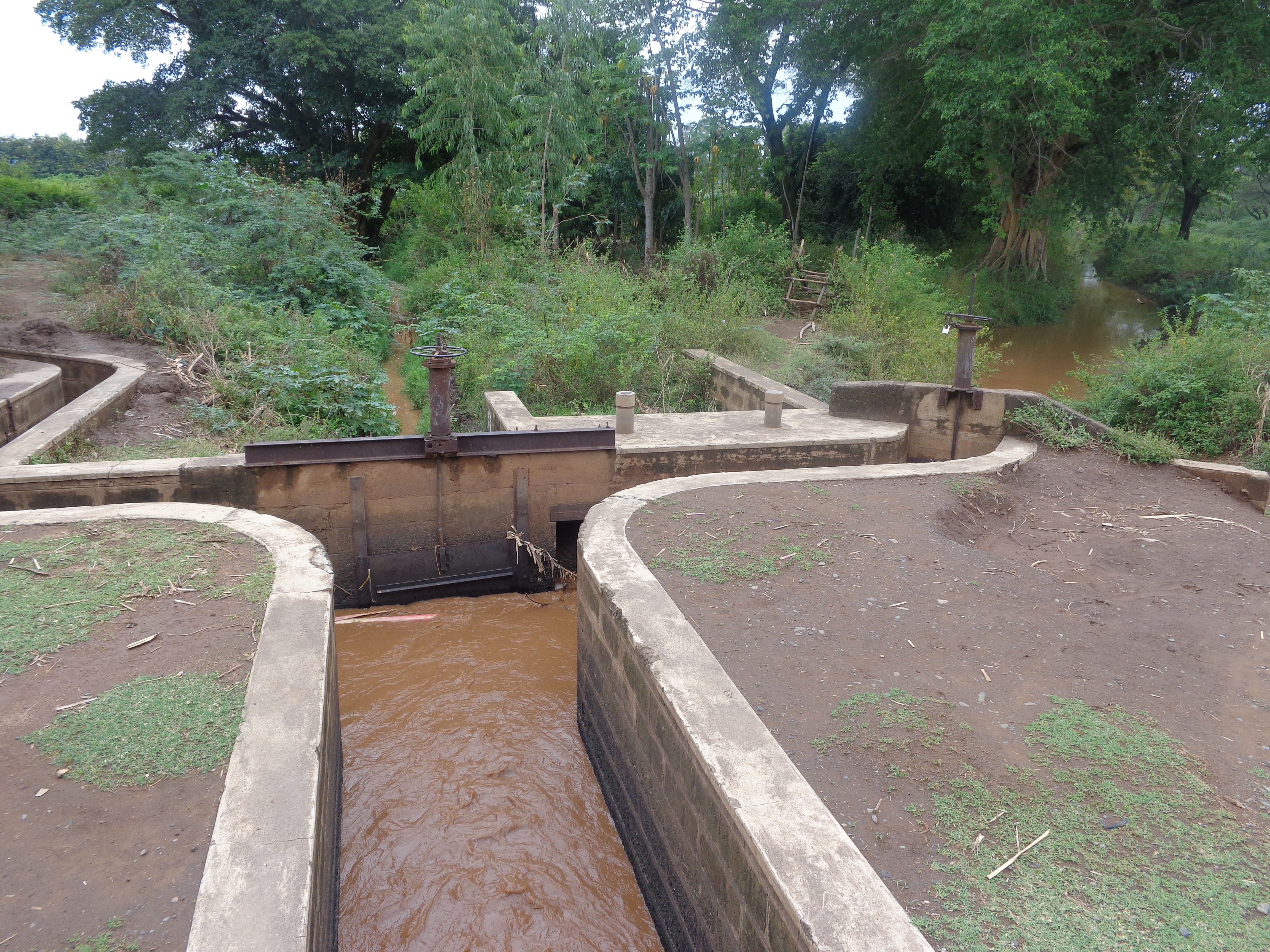
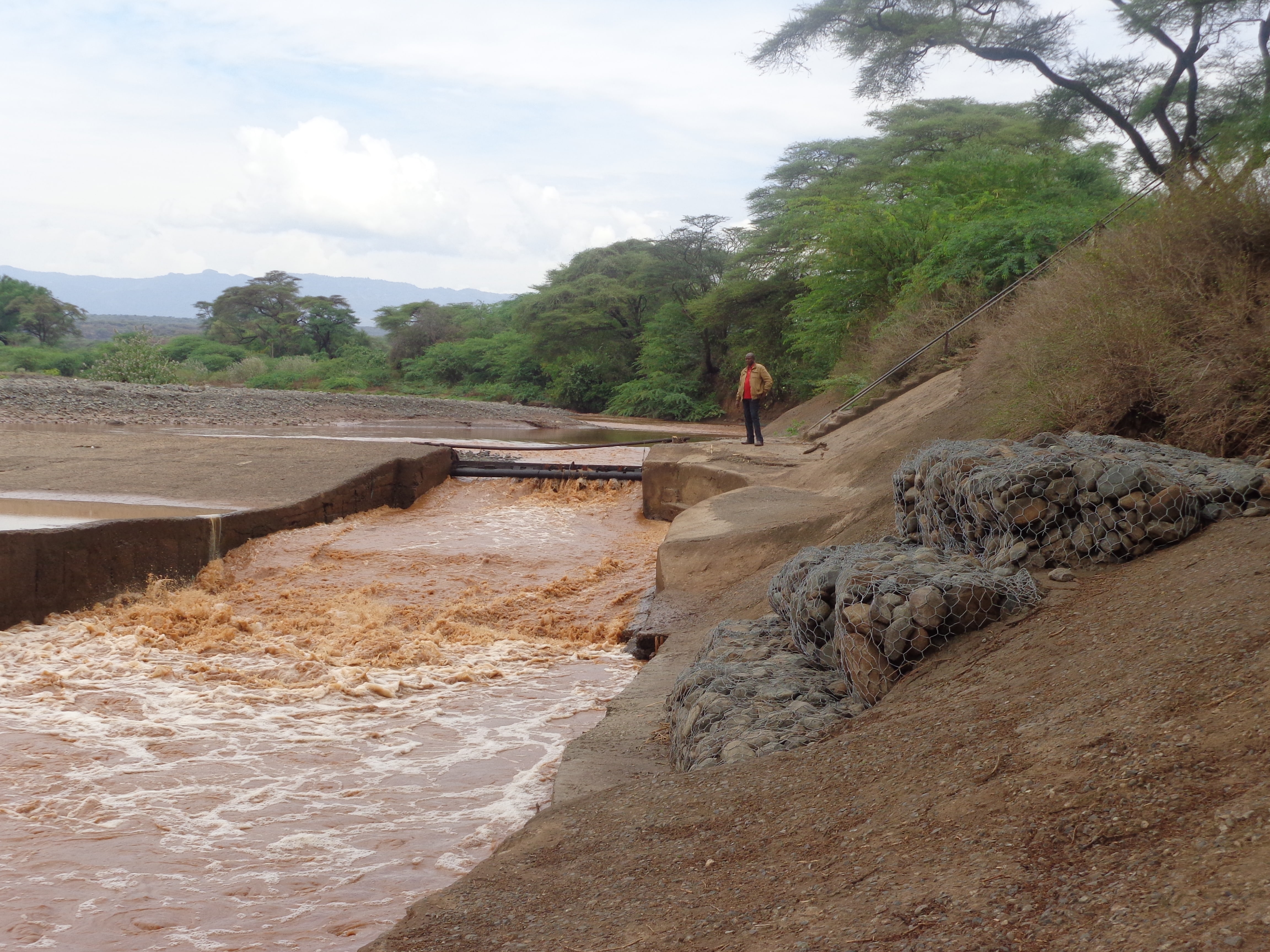
This is an open-furrow system consisting barriers constructed along a water source such as a river to direct water through a conveyance system by gravity into feeder channels to cultivated land. It is a simple method entailing control of water flow rate and direction to improve water utilization efficiency and enhance productivity of land.
2.2 Detailed description of the Technology
Description:
Perkerra irrigation scheme was constructed by the colonial government in 1945 to ensure efficient water utilization, enhance soil productivity and food security. It is an open-furrow system consisting barriers constructed along a water source such as a river to direct water through a conveyance system by gravity into feeder channels to cultivated land. Water control system is constructed between the conveyance and the feeder channels to control the direction and speed of the water.
This technology is suitable on fairly flat, irrigable land with reliable water sources for irrigation. Consideration of population structure is crucial in ascertaining the availability labor force in farmlands. Depending on the size and market orientation of the production system, a stable market is also an important consideration.
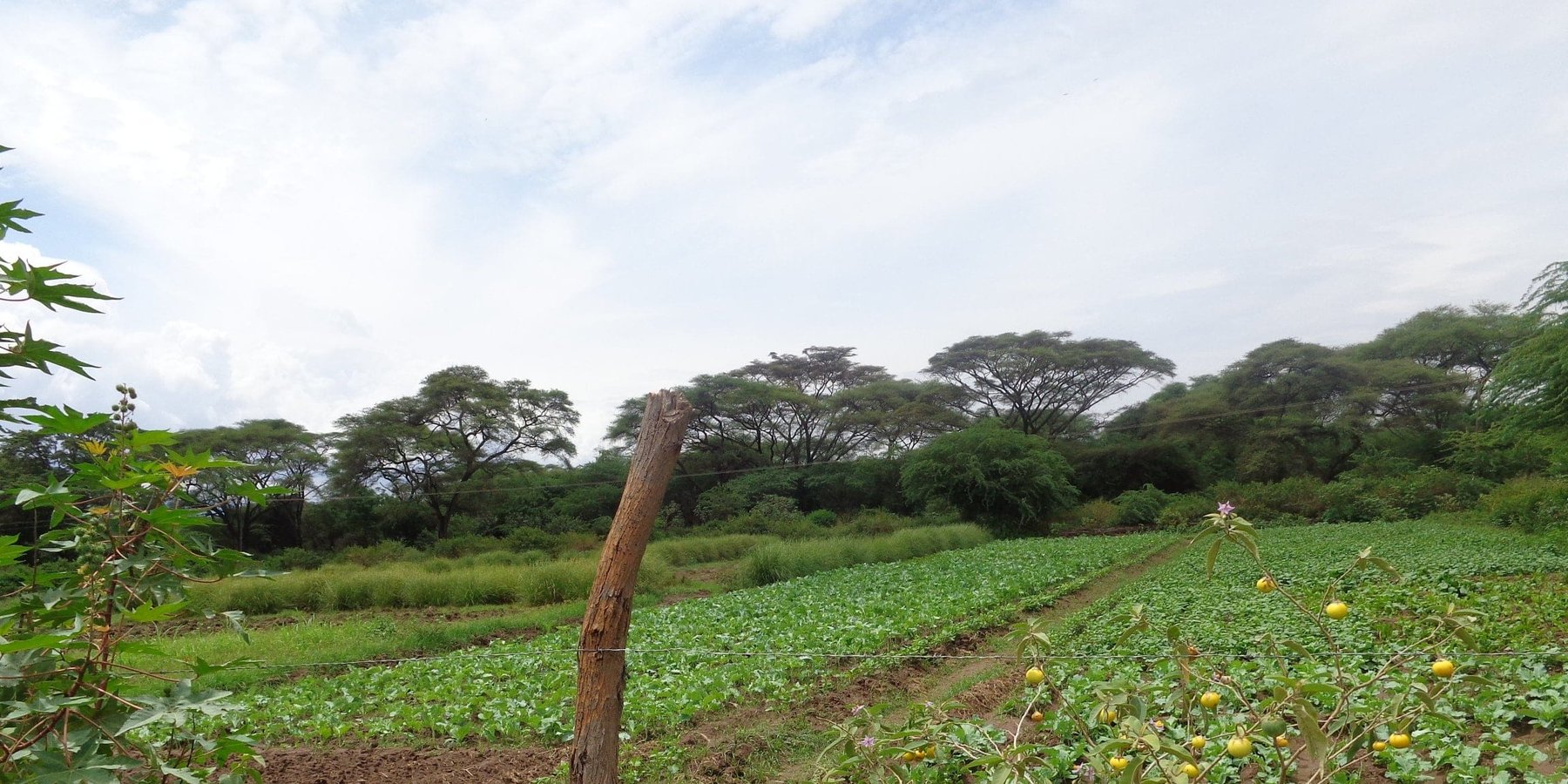
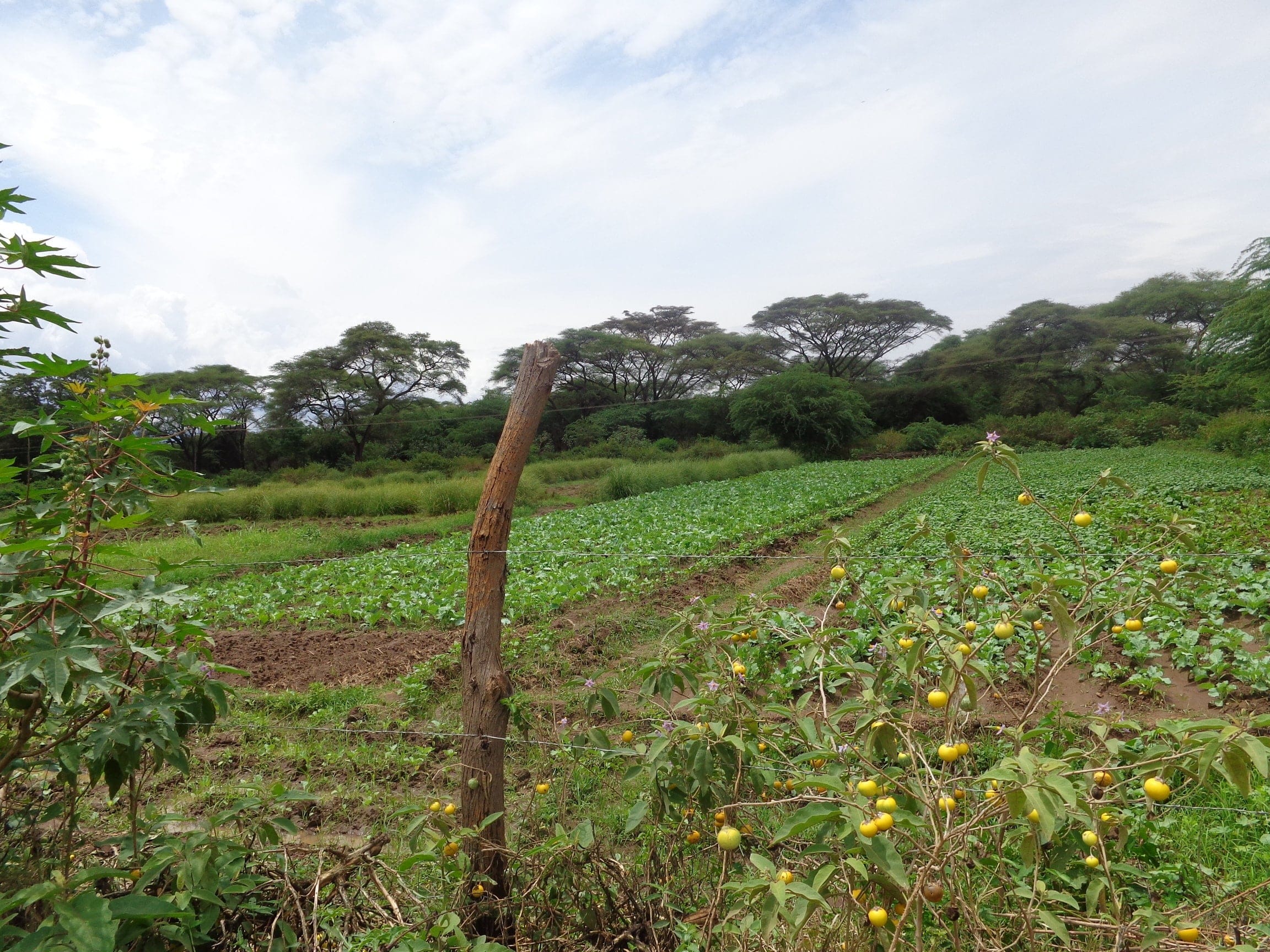
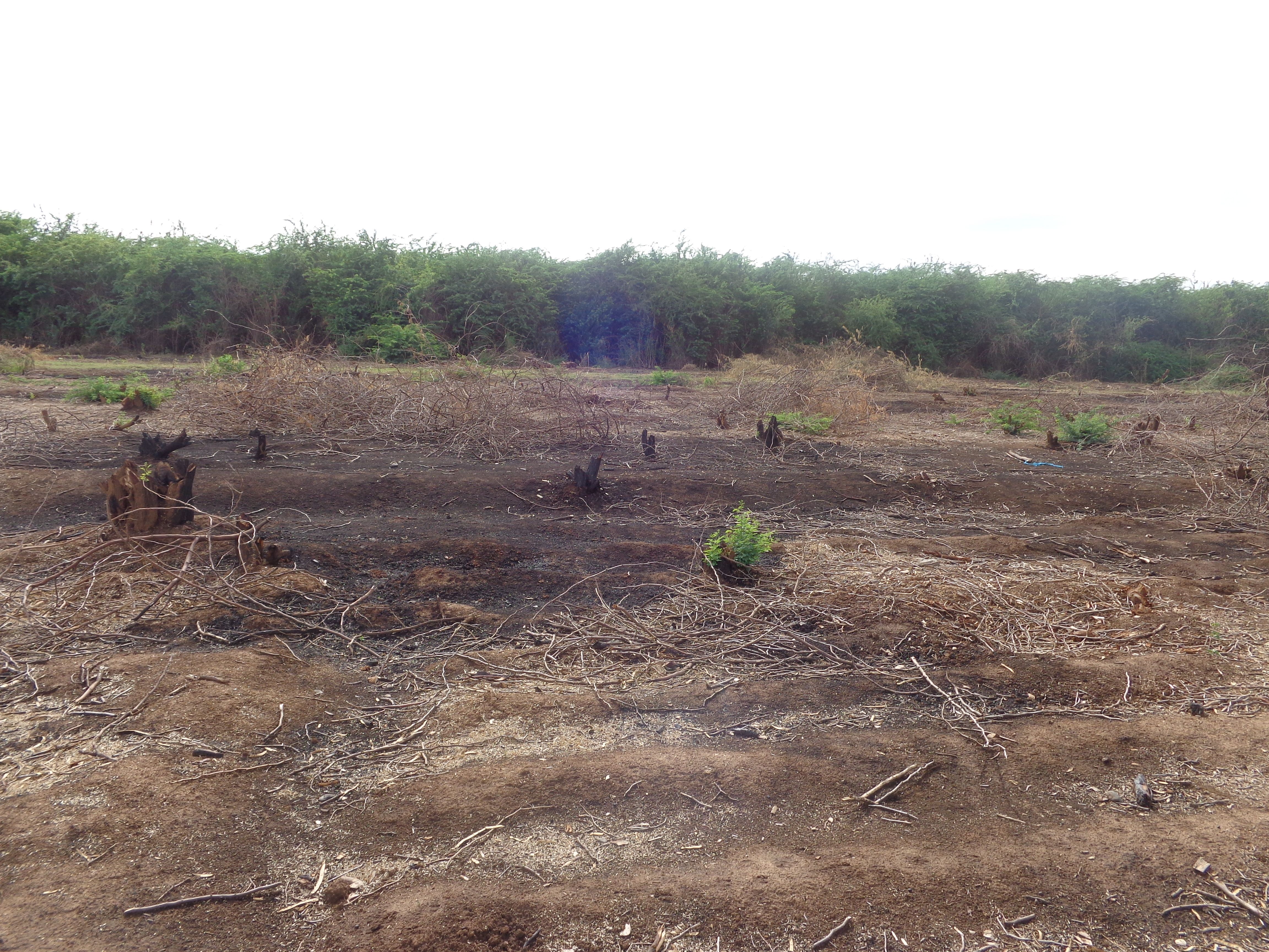
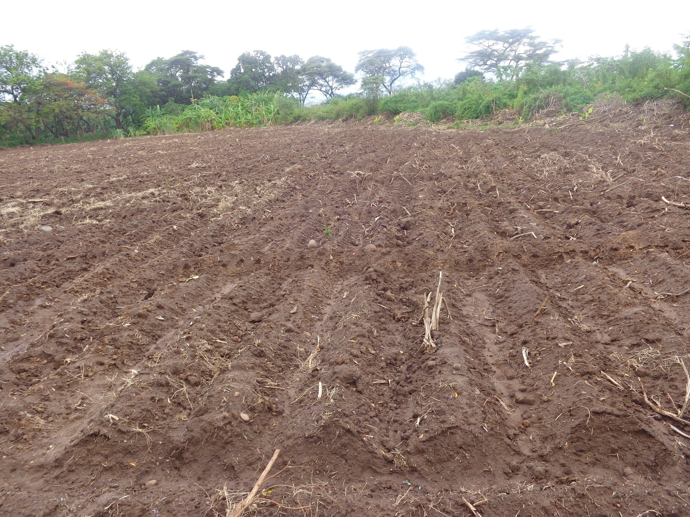
Irrigated farming in the scheme is carried out in 3 seasons a year due to availability of reliable water from the permanent Perkerra River. This also ensures that land is never left idle for re-invasion of Prosopis. Activities commence with land clearance conducted at the beginning of every planting season. Prosopis on invaded farmlands are manually cut, burnt and uprooted to minimize chances of the invasive tree from coppicing. The uprooted trunk is utilized in charcoal production for commercial purposes while the small branches are used as firewood for domestic cooking.
The cleared land is then ploughed using a tractor to break the soil structure and provide a fine tilth for planting. This is followed by mechanized ridging to create channels and buffer furrows to convey and retain water long enough to be infiltrated into the soil. Seeds are then sown, a joint activity carried out through farmers’ cooperation. The scheme was originally specialized for bulb onions plantation but has transformed into more diversified food crops for subsistence and commercial purposes. Crops under contractual farming are seed maize, rice, sunflower, green grams, pepper and cow peas while surplus crops under irrigation include tomatoes, vegetables, water melons, subsistence maize crops and commercial fruit trees. In addition, availability of assured market and payment has made the scheme popular for seed maize cultivation. Ongoing experimental research on a variety sweet potatoes to reduce overdependence on maize crops have also shown promising results and are likely to be recommended for implementation. During planting seasons, fallow periods are replaced by rotational cropping and crop diversification. This improves soil structure by alternating deep and shallow-rooted crops. Replacement of the crop during rotation disrupts the life cycle of disease causing organisms, thus controlling pests and diseases as well as improving crop productivity. Consequently, there is minimal application of chemical pesticides, hence reduced chances of pollution.
The irrigated cultivation has improved the welfare of the community by diversifying their sources of livelihood from pastoralism, enhancing food security, eradication of poverty and improving infrastructure such as access roads to the farms. It is a major source of income, directly supporting 1,625 farm households earning an approximate total net income of Ksh. 148, 192,259 Million (Perkerra scheme brief prepared by the National Irrigation board, 2017). Each household is assigned between 0.5 to 4 acres of land. This range might however be narrowed in the near future due to the increasing population in demand for the fixed land resource. The other option under consideration is to reclaim more invaded land and expand the scheme. The challenge facing this approach and is yet to be addressed is limited water resources to sustain the expansion. Lack of suitable market for non-contractual crops as well as poor pricing due to monopolization by contracting institutions is also a great setback to this technology. A good example is the abandonment of pawpaw production by farmers due to marketing problems.
2.3 Photos of the Technology
Media Gallery
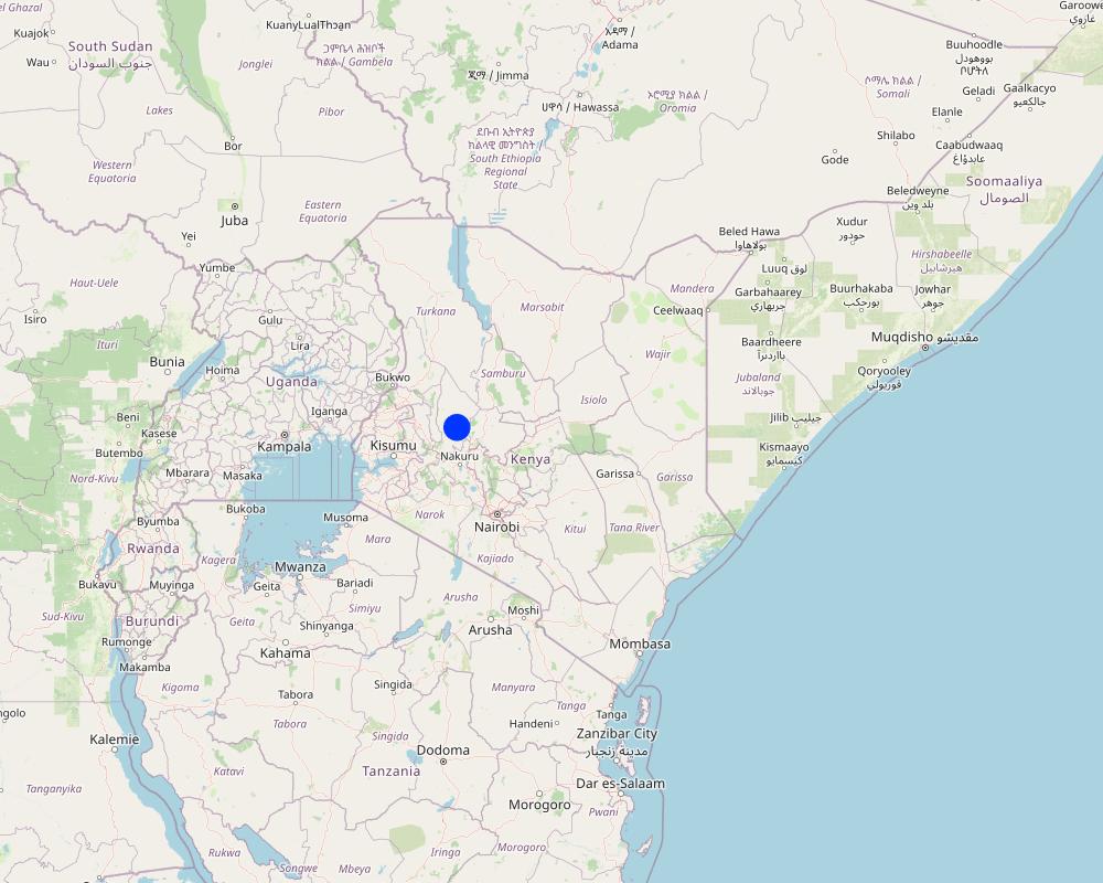
2.5 Country/ region/ locations where the Technology has been applied and which are covered by this assessment
Country:
Kenya
Region/ State/ Province:
Baringo County
Further specification of location:
Marigat sub-couty
Map
×2.6 Date of implementation
If precise year is not known, indicate approximate date:
- more than 50 years ago (traditional)
2.7 Introduction of the Technology
Specify how the Technology was introduced:
- through projects/ external interventions
Comments (type of project, etc.):
The scheme was established during the colonial period through local detainees in Marigat. This followed a feasibility study pointing to the suitability of the IIchamus plain for agricultute,
3. Classification of the SLM Technology
3.1 Main purpose(s) of the Technology
- improve production
- protect a watershed/ downstream areas – in combination with other Technologies
- create beneficial economic impact
- create beneficial social impact
3.2 Current land use type(s) where the Technology is applied

Mixed (crops/ grazing/ trees), incl. agroforestry
- Agroforestry
Main products/ services:
Contracted crops: Seed maize, green grams, sunflower
Surplus crops: tomatoes, vegetables, assorted fruit and tree seedlings, pepper

Waterways, waterbodies, wetlands
- Drainage lines, waterways
If land use has changed due to the implementation of the Technology, indicate land use before implementation of the Technology:
IIchamus plain was initially a pastoral land for grazing. Being a state owned land with no one held responsible for its management, the land was poorly managed by the society.
3.3 Further information about land use
Water supply for the land on which the Technology is applied:
- mixed rainfed-irrigated
Comments:
Channeling of irrigation water into farms is restricted to dry seasons and temporarily halted during the rainy season.
Number of growing seasons per year:
- 3
Specify:
The irrigation scheme is subjected to continuous cultivation with contracted crops planted in 2 seasons and a surplus crop on a third season in a year. Crop rotation and diversification is practiced to improve soil productivity, control pests, reduce soil erosion and enhance soil structure.
3.4 SLM group to which the Technology belongs
- rotational systems (crop rotation, fallows, shifting cultivation)
- irrigation management (incl. water supply, drainage)
- water diversion and drainage
3.5 Spread of the Technology
Specify the spread of the Technology:
- evenly spread over an area
If the Technology is evenly spread over an area, indicate approximate area covered:
- > 10,000 km2
Comments:
The technology are specifically applied along the irrigation scheme with sufficient water for irrigation
3.6 SLM measures comprising the Technology

agronomic measures
- A1: Vegetation/ soil cover
- A2: Organic matter/ soil fertility
- A5: Seed management, improved varieties

vegetative measures
- V3: Clearing of vegetation
- V4: Replacement or removal of alien/ invasive species

structural measures
- S2: Bunds, banks
- S5: Dams, pans, ponds
- S7: Water harvesting/ supply/ irrigation equipment

management measures
- M1: Change of land use type
- M4: Major change in timing of activities
- M5: Control/ change of species composition
3.7 Main types of land degradation addressed by the Technology

soil erosion by water
- Wt: loss of topsoil/ surface erosion

soil erosion by wind
- Et: loss of topsoil

chemical soil deterioration
- Cn: fertility decline and reduced organic matter content (not caused by erosion)
- Cs: salinization/ alkalinization

biological degradation
- Bh: loss of habitats
- Bq: quantity/ biomass decline
- Bs: quality and species composition/ diversity decline
- Bp: increase of pests/ diseases, loss of predators

water degradation
- Ha: aridification
3.8 Prevention, reduction, or restoration of land degradation
Specify the goal of the Technology with regard to land degradation:
- restore/ rehabilitate severely degraded land
4. Technical specifications, implementation activities, inputs, and costs
4.1 Technical drawing of the Technology
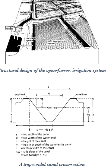
Author:
Brouwer, C., Goffeau, A., and Heibloem, M.
4.2 Technical specifications/ explanations of technical drawing
The intake structure convey water from the main water source to the irrigation system. It may consist of a water pump or a barrier designed for this purpose. The water is directed to a conveyance system of open canals which control the flow and direction of water to different field application and distribution systems. The canals depth (h) is preferred to exceed the expected maximum water level (h){h>h1} of water within the irrigation system to minimize bank overflow. The side slope is a ratio of the vertical height to the horizontal canal width (h:w). They are fitted with water measurement, erosion and distribution control structures to regulate accurate distribution of water to the farms with minimum siltation of the banks. The water is then distributed to field ditches which transfer it to the irrigated farm. These are narrow waterways dug along the farms with checks across their lengths to hold and raise the upstream water levels long enough before releasing it to the next segment of the field ditch. This is meant to increase the rate of water infiltration into the soil.
4.3 General information regarding the calculation of inputs and costs
Specify how costs and inputs were calculated:
- per Technology unit
Specify unit:
hactares
Specify volume, length, etc. (if relevant):
1
other/ national currency (specify):
KES
Indicate exchange rate from USD to local currency (if relevant): 1 USD =:
100.0
Indicate average wage cost of hired labour per day:
500
4.4 Establishment activities
| Activity | Type of measure | Timing | |
|---|---|---|---|
| 1. | Construct gravity intake system | Structural | Once during establishment |
| 2. | Excavation of water canals | Structural | Once during establishment |
| 3. | Establishment of water control structures | Structural | Once during establishment |
| 4. | Land preparation ( Clearance and partitioning) | Structural | Once during establishment |
| 5. | Construction of a suitable road network | Structural | Once during establishment |
Comments:
Activities involved are the construction of a gravity intake system, excavation of water canals, construction of a suitable road network and water control structures. Prior considerations are reliable water source, availability of irrigable land and labor for cultivation.
4.5 Costs and inputs needed for establishment
If possible, break down the costs of establishment according to the following table, specifying inputs and costs per input. If you are unable to break down the costs, give an estimation of the total costs of establishing the Technology:
600000000.0
Comments:
The initial establishment and construction of the irrigation infrastructure is often conducted by the national government due to associated high costs approximated by key informants to be Ksh, 600, 000,000 (600,000 USD). This is however an initial, one off expenditure that are non-recurrent.
4.6 Maintenance/ recurrent activities
| Activity | Type of measure | Timing/ frequency | |
|---|---|---|---|
| 1. | Clearing land | Agronomic | 3 times a year before every planting season. |
| 2. | Ploughing | Agronomic | 3 times a year before every planting season. |
| 3. | Ridging/Cutting furrows | Structural | 3 times a year before every planting season. |
| 4. | De-silting of canals | Management | 3 times a year before every planting season. |
| 5. | Planting | Agronomic | 3 times a year. |
| 6. | first irrigation | Structural | 3 times a year after planting (3 to 5 days per season) |
| 7. | Pest control | Agronomic | Whenever applicable |
| 8. | Weeding | Agronomic | Once every season |
| 9. | Second irrigation | Structural | 10 to 12 (each time withinn 3 to 4 days) per planting season. |
| 10. | Top dressing ( Apply fertilizer) | Agronomic | Once every season |
| 11. | Harvesting | Agronomic | Once every season |
| 12. | Shelling | Agronomic | Once every season |
Comments:
Maintenance activities mentioned above are dependent on the status of an individual's farm, availability of resources and the purpose for cultivation. Farm produce cultivated under contracted terms will however need to follow strict procedures for them to meet the minimum requirements.
4.7 Costs and inputs needed for maintenance/ recurrent activities (per year)
| Specify input | Unit | Quantity | Costs per Unit | Total costs per input | % of costs borne by land users | |
|---|---|---|---|---|---|---|
| Labour | Land clearance | Man-hour | 540.0 | 120.0 | 64800.0 | 100.0 |
| Labour | Partitioning | Man-hour | 180.0 | 100.0 | 18000.0 | 100.0 |
| Labour | Planting | Man-hour | 90.0 | 100.0 | 9000.0 | 100.0 |
| Equipment | Ploughing tractor | Hours | 18.0 | 420.0 | 7560.0 | 100.0 |
| Equipment | Ridging tractor | Hours | 18.0 | 420.0 | 7560.0 | 100.0 |
| Plant material | Seeds and seedlings | Kg | 75.0 | 150.0 | 11250.0 | 100.0 |
| Plant material | Channeling water for irrigation | Season | 3.0 | 2000.0 | 6000.0 | 100.0 |
| Fertilizers and biocides | Fertilizer | Kg | 150.0 | 50.0 | 7500.0 | 100.0 |
| Total costs for maintenance of the Technology | 131670.0 | |||||
4.8 Most important factors affecting the costs
Describe the most determinate factors affecting the costs:
Size of land
Disease and pest outbreak
Crop variety as contracted crops minimum requirements which may be costly to meet
Occurrence of rainy seasons especially during harvesting which affect the drying cost and output of produce. Seed maize, for example, may not meet the required moisture content when aired during the rainy season hence lowering the net income from them.
Condition of the farm e.g invasion level by Prosopis
5. Natural and human environment
5.1 Climate
Annual rainfall
- < 250 mm
- 251-500 mm
- 501-750 mm
- 751-1,000 mm
- 1,001-1,500 mm
- 1,501-2,000 mm
- 2,001-3,000 mm
- 3,001-4,000 mm
- > 4,000 mm
Specify average annual rainfall (if known), in mm:
671.00
Specifications/ comments on rainfall:
Rainfall is characterized by seasonal and annual fluctuations
Agro-climatic zone
- semi-arid
The area is in a semi-arid zone with temperatures ranging between 16 to 36 degrees, averagely 24.6 degrees, accompanied by high evaporation rates of up to 6mm. It experiences an average rainfall of 671 mm annually which are very erratic.
5.2 Topography
Slopes on average:
- flat (0-2%)
- gentle (3-5%)
- moderate (6-10%)
- rolling (11-15%)
- hilly (16-30%)
- steep (31-60%)
- very steep (>60%)
Landforms:
- plateau/plains
- ridges
- mountain slopes
- hill slopes
- footslopes
- valley floors
Altitudinal zone:
- 0-100 m a.s.l.
- 101-500 m a.s.l.
- 501-1,000 m a.s.l.
- 1,001-1,500 m a.s.l.
- 1,501-2,000 m a.s.l.
- 2,001-2,500 m a.s.l.
- 2,501-3,000 m a.s.l.
- 3,001-4,000 m a.s.l.
- > 4,000 m a.s.l.
Indicate if the Technology is specifically applied in:
- not relevant
Comments and further specifications on topography:
The technology is applied in relatively flat land to increase water retention long enough to be infiltrated into the soil
5.3 Soils
Soil depth on average:
- very shallow (0-20 cm)
- shallow (21-50 cm)
- moderately deep (51-80 cm)
- deep (81-120 cm)
- very deep (> 120 cm)
Soil texture (topsoil):
- fine/ heavy (clay)
Soil texture (> 20 cm below surface):
- fine/ heavy (clay)
Topsoil organic matter:
- low (<1%)
If available, attach full soil description or specify the available information, e.g. soil type, soil PH/ acidity, Cation Exchange Capacity, nitrogen, salinity etc.
Clay soil with alkaline pH of 7.5 , rich in calcium phosphate but low in organic matter
5.4 Water availability and quality
Availability of surface water:
good
Water quality (untreated):
for agricultural use only (irrigation)
Is water salinity a problem?
Yes
Is flooding of the area occurring?
Yes
5.5 Biodiversity
Species diversity:
- low
Habitat diversity:
- low
Comments and further specifications on biodiversity:
Prosopis has heavily invaded the land, encroaching agro-pastoral land and outcompeting native species leading to degradation of native species and habitats.
5.6 Characteristics of land users applying the Technology
Sedentary or nomadic:
- Sedentary
Market orientation of production system:
- mixed (subsistence/ commercial
Off-farm income:
- 10-50% of all income
Relative level of wealth:
- poor
Individuals or groups:
- individual/ household
Level of mechanization:
- manual work
- mechanized/ motorized
Gender:
- women
- men
Age of land users:
- middle-aged
- elderly
5.7 Average area of land owned or leased by land users applying the Technology
- < 0.5 ha
- 0.5-1 ha
- 1-2 ha
- 2-5 ha
- 5-15 ha
- 15-50 ha
- 50-100 ha
- 100-500 ha
- 500-1,000 ha
- 1,000-10,000 ha
- > 10,000 ha
Is this considered small-, medium- or large-scale (referring to local context)?
- large-scale
Comments:
Current land allocated by the government for the practice is an estimate of 1,800 ha. Pressure due to population increase has however triggered plans for future expansion.
5.8 Land ownership, land use rights, and water use rights
Land ownership:
- state
Land use rights:
- communal (organized)
Water use rights:
- communal (organized)
Comments:
The scheme is state owned , leased to the community who nominate a 7 member advisory committee tasked with all land administration aspects ranging from land adjudication, allocation, succession and dispute management as well as set laws guiding water utilization and conservation.
5.9 Access to services and infrastructure
health:
- poor
- moderate
- good
education:
- poor
- moderate
- good
technical assistance:
- poor
- moderate
- good
employment (e.g. off-farm):
- poor
- moderate
- good
markets:
- poor
- moderate
- good
energy:
- poor
- moderate
- good
roads and transport:
- poor
- moderate
- good
drinking water and sanitation:
- poor
- moderate
- good
financial services:
- poor
- moderate
- good
6. Impacts and concluding statements
6.1 On-site impacts the Technology has shown
Socio-economic impacts
Production
crop production
production area
Quantity before SLM:
567 ha
Quantity after SLM:
1,745 ha
Comments/ specify:
the area developed for furrow irrigation has increased by 1,178 ha between 1958 when the operations begun to date. This is more than twice the initial land size allocated and utilized for irrigation purposes.
land management
Comments/ specify:
Development of the technology has transformed it from an open access to an organized communal tenure system with communally-designed restrictions to its access, utilization and management.
Water availability and quality
water quality for livestock
Comments/ specify:
There are chances of water pollution when contaminated irrigation water flows back to the animal watering points.
demand for irrigation water
Comments/ specify:
The progressive increase of area under cultivation as well as prolonged dry seasons over the years have culminated into increased water consumption hence a high demand for the same.
Income and costs
farm income
Quantity after SLM:
Net income of 148 192 259 million Kenya shillings
diversity of income sources
Comments/ specify:
Farming activities have diversified and increased income sources to the community who depended mainly on pastoralism. This has been enhanced by a wide variety of crops being cultivated through irrigation.
workload
Comments/ specify:
Farming activities (tedious cutting, burning and uprooting of Prosopis in invaded farms, ploughing, weeding and harvesting) are all physical activities that increase the workload of the communities involved.
Ecological impacts
Biodiversity: vegetation, animals
Vegetation cover
biomass/ above ground C
plant diversity
invasive alien species
Comments/ specify:
Irrigated land has to undergo clearance of all Invasive species, in this case, Prosopis during land preparation activities. This is carried out through a cut-burn-uproot approach to minimize chances of their proliferation. Any re-growing invasive plant is uprooted before maturity to prevent further competition for water and nutrient with cultivated crops. Chances of re-invasion are also minimized as land is never left idle for colonization by Prosopis. This has greatly decreased invasive cover on irrigated land.
Climate and disaster risk reduction
drought impacts
Comments/ specify:
Drought related impacts such as malnutrition, famine and death have been reduced by irrigation practices which increases food insecurity independent of the season.
6.2 Off-site impacts the Technology has shown
water availability
Comments/ specify:
Diversion of water into open channels for irrigation reduce the downstream flow for offsite usage downstream.
downstream flooding
Comments/ specify:
Potential flood water are diverted to farms hence reducing downstream flooding. However, this impact may not be significant during heavy downpours where diversion valves are closed to prevent unnecessary water logging on farmlands.
6.3 Exposure and sensitivity of the Technology to gradual climate change and climate-related extremes/ disasters (as perceived by land users)
Gradual climate change
Gradual climate change
| Season | Type of climatic change/ extreme | How does the Technology cope with it? | |
|---|---|---|---|
| seasonal rainfall | wet/ rainy season | increase | moderately |
Climate-related extremes (disasters)
Biological disasters
| How does the Technology cope with it? | |
|---|---|
| epidemic diseases | not well at all |
| insect/ worm infestation | not well at all |
6.4 Cost-benefit analysis
How do the benefits compare with the establishment costs (from land users’ perspective)?
Short-term returns:
slightly positive
Long-term returns:
positive
How do the benefits compare with the maintenance/ recurrent costs (from land users' perspective)?
Short-term returns:
slightly positive
Long-term returns:
positive
6.5 Adoption of the Technology
- 1-10%
If available, quantify (no. of households and/ or area covered):
Direct beneficiaries of the technologies are about 13,000 people. However, indirect beneficiaries from the transportation and sale of the produce may double this number
Of all those who have adopted the Technology, how many have did so spontaneously, i.e. without receiving any material incentives/ payments?
- 90-100%
Comments:
All operation are carried out at the full expense of the land users. Credits advanced to them have to be repaid with at least 11% interest
6.6 Adaptation
Has the Technology been modified recently to adapt to changing conditions?
Yes
If yes, indicate to which changing conditions it was adapted:
- climatic change/ extremes
Specify adaptation of the Technology (design, material/ species, etc.):
Water conveyance along the furrows to the farms is halted during heavy downpour to minimize water logging.
6.7 Strengths/ advantages/ opportunities of the Technology
| Strengths/ advantages/ opportunities in the land user’s view |
|---|
| A source of finance to land users through sale of their produce. |
| Strengths/ advantages/ opportunities in the compiler’s or other key resource person’s view |
|---|
| Continuous farming activities have ensured that land is constantly managed, limiting the proliferation of Prosopis weeds which have adverse impacts to the ecosystem and livelihoods. |
| Improved human welfare by enhancing their financial stability. An extension of this is indirect benefit through employment creation to farm laborers, merchants and buyers of the fresh and healthy farm produce. |
| Increased food security |
6.8 Weaknesses/ disadvantages/ risks of the Technology and ways of overcoming them
| Weaknesses/ disadvantages/ risks in the land user’s view | How can they be overcome? |
|---|---|
| Poor market prices for their produce. | They feel they have no option due to inadequate knowledge and access to other available markets |
| Pests and disease out break such as the fall armyworm. | Advisory services are offered by research institutions to stakeholders on how to manage and control pests. |
| Weaknesses/ disadvantages/ risks in the compiler’s or other key resource person’s view | How can they be overcome? |
|---|---|
| Monopoly of the market by the contracting institutions may lead to poor pricing or tight minimum requirements such as the quality of output leading to losses. | Diversification of market to tighten competition that may offer better prices to farmers. |
| High chances of water pollution by chemicals and fertilizers that may be washed away by the running water | Minimize application of chemicals as possible accompanied by integrated nutrient management practices. |
| Post harvest losses when supply exceeds demand | Proper timing of planting season whereby harvesting coincides with seasons of shortage and scarcity to maximize returns. |
7. References and links
7.1 Methods/ sources of information
- field visits, field surveys
2
- interviews with land users
2
- interviews with SLM specialists/ experts
3
- compilation from reports and other existing documentation
2
7.2 References to available publications
Title, author, year, ISBN:
Brouwer, C., Goffeau, A., and Heibloem, M. (1985): Irrigation Water Management: Training Manual No. 1
Available from where? Costs?
http://www.fao.org/docrep/r4082e/r4082e00.htm#Contents
7.3 Links to relevant information which is available online
Title/ description:
Perkerra Irrigation scheme Brief
URL:
https://www.nib.or.ke/projects/public-irrigation-schemes/perkerra-irrigation-scheme
Title/ description:
The 9 Benefits of Crop Rotation to the Environment
URL:
http://richmondvale.org/crop-rotation/
Links and modules
Expand all Collapse allLinks
No links
Modules
No modules