Technologies
Залужение деградированных пастбищ в условиях высокогорья [Tajikistan]
- Creation:
- Update:
- Compiler: MIZROBSHO AMIRBEKOV
- Editor: –
- Reviewer: Farrukh Nazarmavloev
Обёри ва баркарорсозии заминхои фарсоишёфтаи чарогох
technologies_3698 - Tajikistan
View sections
Expand all Collapse all
Completeness: 73%
1. General information
1.2 Contact details of resource persons and institutions involved in the assessment and documentation of the Technology
Name of project which facilitated the documentation/ evaluation of the Technology (if relevant)
Mountain Societies Development Support Programme, TajikistanName of the institution(s) which facilitated the documentation/ evaluation of the Technology (if relevant)
Institute for Environment and Human Security, United Nations University (Institute for Environment and Human Security, United Nations University) - Germany1.3 Conditions regarding the use of data documented through WOCAT
When were the data compiled (in the field)?
15/06/2011
The compiler and key resource person(s) accept the conditions regarding the use of data documented through WOCAT:
Yes
1.4 Declaration on sustainability of the described Technology
Is the Technology described here problematic with regard to land degradation, so that it cannot be declared a sustainable land management technology?
No
2. Description of the SLM Technology
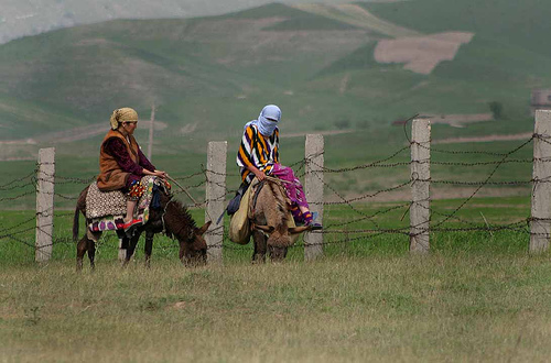
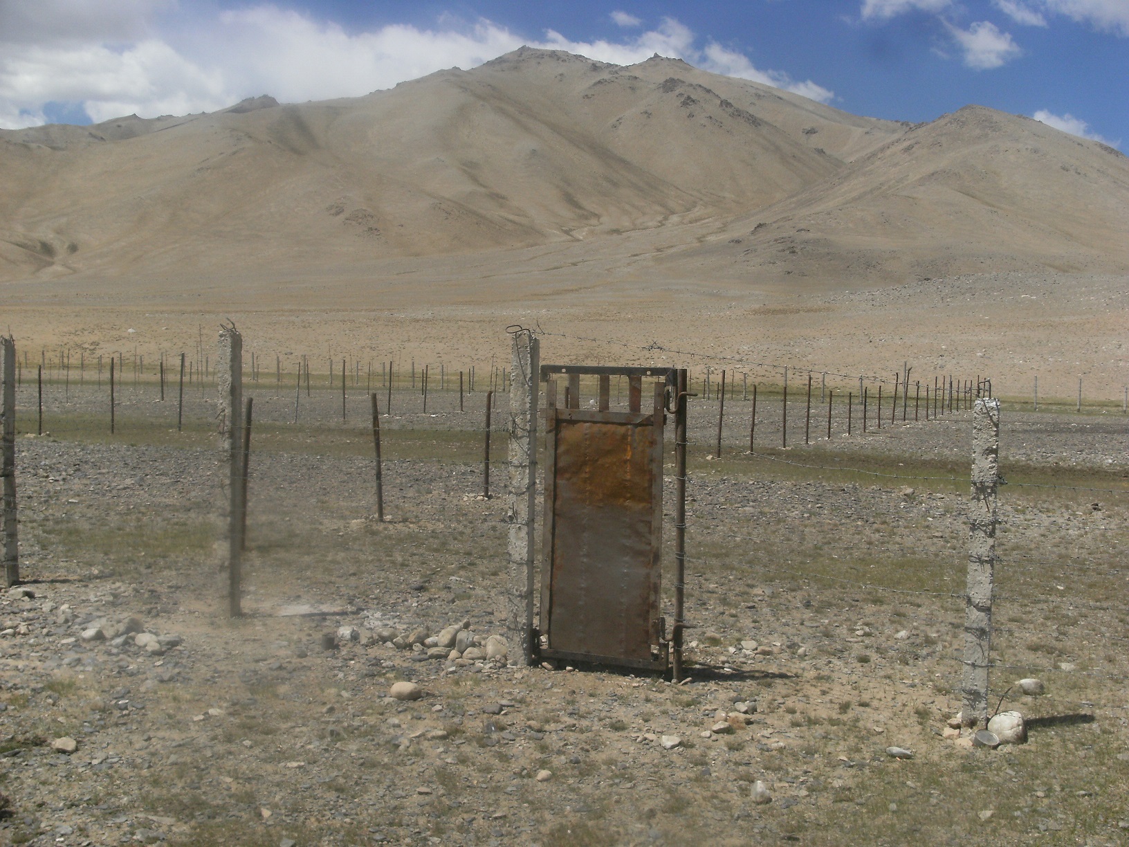
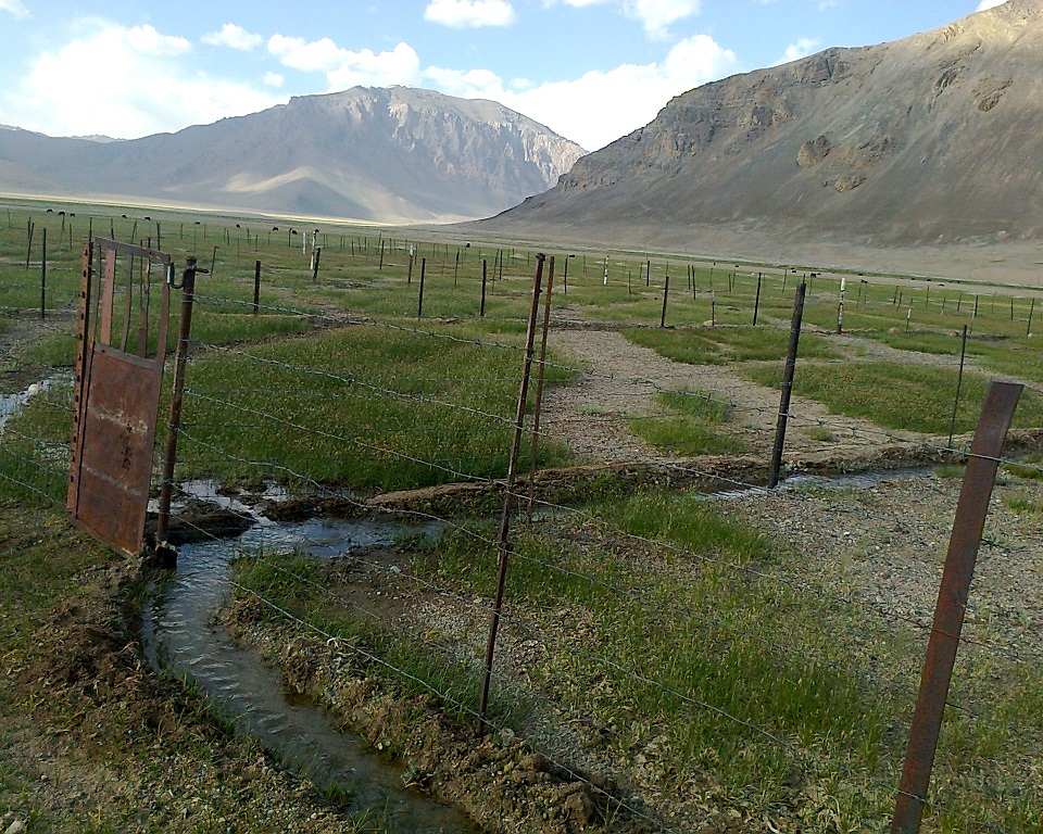
2.3 Photos of the Technology
Media Gallery
2.5 Country/ region/ locations where the Technology has been applied and which are covered by this assessment
Country:
Tajikistan
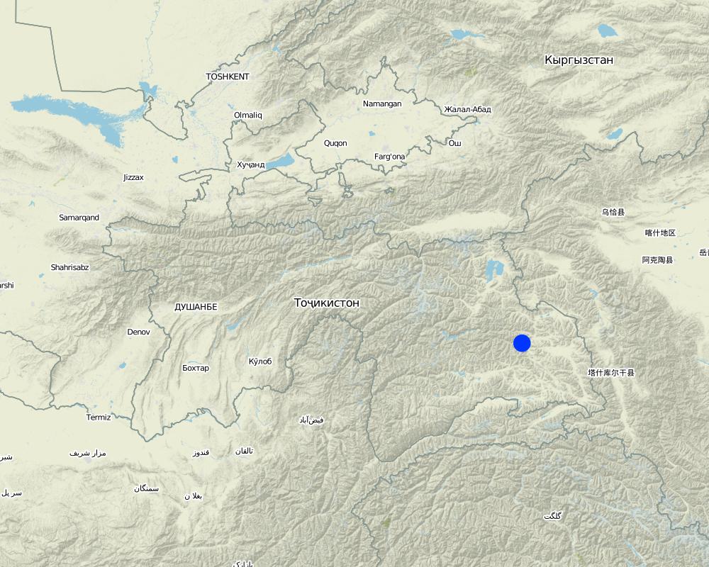
Map
×2.6 Date of implementation
If precise year is not known, indicate approximate date:
- less than 10 years ago (recently)
2.7 Introduction of the Technology
Specify how the Technology was introduced:
- through projects/ external interventions
3. Classification of the SLM Technology
3.1 Main purpose(s) of the Technology
- improve production
- reduce, prevent, restore land degradation
- conserve ecosystem
- preserve/ improve biodiversity
3.2 Current land use type(s) where the Technology is applied

Grazing land
Extensive grazing land:
- Nomadism
Intensive grazing/ fodder production:
- Improved pastures
3.3 Further information about land use
Number of growing seasons per year:
- 1
3.4 SLM group to which the Technology belongs
- pastoralism and grazing land management
- improved ground/ vegetation cover
- ecosystem-based disaster risk reduction
3.5 Spread of the Technology
Specify the spread of the Technology:
- evenly spread over an area
If the Technology is evenly spread over an area, indicate approximate area covered:
- 1-10 km2
3.6 SLM measures comprising the Technology

agronomic measures
- A1: Vegetation/ soil cover
- A2: Organic matter/ soil fertility

vegetative measures
- V2: Grasses and perennial herbaceous plants

structural measures
- S6: Walls, barriers, palisades, fences

management measures
- M2: Change of management/ intensity level
- M3: Layout according to natural and human environment
- M4: Major change in timing of activities
3.7 Main types of land degradation addressed by the Technology

soil erosion by water
- Wt: loss of topsoil/ surface erosion
- Wg: gully erosion/ gullying
- Wr: riverbank erosion
- Wo: offsite degradation effects

soil erosion by wind
- Et: loss of topsoil
- Eo: offsite degradation effects

chemical soil deterioration
- Cp: soil pollution

physical soil deterioration
- Pc: compaction
- Pu: loss of bio-productive function due to other activities

biological degradation
- Bc: reduction of vegetation cover
- Bh: loss of habitats
- Bq: quantity/ biomass decline
- Bf: detrimental effects of fires
- Bs: quality and species composition/ diversity decline
- Bl: loss of soil life
3.8 Prevention, reduction, or restoration of land degradation
Specify the goal of the Technology with regard to land degradation:
- prevent land degradation
- restore/ rehabilitate severely degraded land
4. Technical specifications, implementation activities, inputs, and costs
4.1 Technical drawing of the Technology

Date:
27/07/2011
4.3 General information regarding the calculation of inputs and costs
Specify how costs and inputs were calculated:
- per Technology unit
Specify currency used for cost calculations:
- US Dollars
Indicate exchange rate from USD to local currency (if relevant): 1 USD =:
8.94
4.4 Establishment activities
| Activity | Type of measure | Timing | |
|---|---|---|---|
| 1. | None | Structural | None |
| 2. | None | Structural | None |
| 3. | None | Structural | None |
| 4. | None | Management | None |
4.5 Costs and inputs needed for establishment
| Specify input | Unit | Quantity | Costs per Unit | Total costs per input | % of costs borne by land users | |
|---|---|---|---|---|---|---|
| Labour | None | None | 10.0 | 30.0 | 300.0 | |
| Labour | None | None | 1.0 | 300.0 | 300.0 | |
| Labour | None | None | 30.0 | 10.0 | 300.0 | |
| Equipment | None | None | 1600.0 | 1.7 | 2720.0 | |
| Equipment | None | None | 200.0 | 2.5 | 500.0 | |
| Total costs for establishment of the Technology | 4120.0 | |||||
4.6 Maintenance/ recurrent activities
| Activity | Type of measure | Timing/ frequency | |
|---|---|---|---|
| 1. | None | Management | None |
| 2. | None | Agronomic | None |
| 3. | None | Agronomic | None |
| 4. | None | Management | None |
4.7 Costs and inputs needed for maintenance/ recurrent activities (per year)
| Specify input | Unit | Quantity | Costs per Unit | Total costs per input | % of costs borne by land users | |
|---|---|---|---|---|---|---|
| Equipment | 1.7 | |||||
| Equipment | 2.5 |
5. Natural and human environment
5.1 Climate
Annual rainfall
- < 250 mm
- 251-500 mm
- 501-750 mm
- 751-1,000 mm
- 1,001-1,500 mm
- 1,501-2,000 mm
- 2,001-3,000 mm
- 3,001-4,000 mm
- > 4,000 mm
Agro-climatic zone
- semi-arid
5.2 Topography
Slopes on average:
- flat (0-2%)
- gentle (3-5%)
- moderate (6-10%)
- rolling (11-15%)
- hilly (16-30%)
- steep (31-60%)
- very steep (>60%)
Landforms:
- plateau/plains
- ridges
- mountain slopes
- hill slopes
- footslopes
- valley floors
Altitudinal zone:
- 0-100 m a.s.l.
- 101-500 m a.s.l.
- 501-1,000 m a.s.l.
- 1,001-1,500 m a.s.l.
- 1,501-2,000 m a.s.l.
- 2,001-2,500 m a.s.l.
- 2,501-3,000 m a.s.l.
- 3,001-4,000 m a.s.l.
- > 4,000 m a.s.l.
Indicate if the Technology is specifically applied in:
- not relevant
5.3 Soils
Soil depth on average:
- very shallow (0-20 cm)
- shallow (21-50 cm)
- moderately deep (51-80 cm)
- deep (81-120 cm)
- very deep (> 120 cm)
Soil texture (topsoil):
- medium (loamy, silty)
Soil texture (> 20 cm below surface):
- medium (loamy, silty)
Topsoil organic matter:
- medium (1-3%)
5.4 Water availability and quality
Ground water table:
5-50 m
Availability of surface water:
good
Water quality (untreated):
good drinking water
Is water salinity a problem?
No
Is flooding of the area occurring?
No
5.5 Biodiversity
Species diversity:
- low
Habitat diversity:
- low
5.6 Characteristics of land users applying the Technology
Sedentary or nomadic:
- Semi-nomadic
Market orientation of production system:
- commercial/ market
Off-farm income:
- 10-50% of all income
Relative level of wealth:
- average
Individuals or groups:
- individual/ household
Level of mechanization:
- manual work
- animal traction
Gender:
- women
- men
Age of land users:
- youth
- middle-aged
5.7 Average area of land owned or leased by land users applying the Technology
- < 0.5 ha
- 0.5-1 ha
- 1-2 ha
- 2-5 ha
- 5-15 ha
- 15-50 ha
- 50-100 ha
- 100-500 ha
- 500-1,000 ha
- 1,000-10,000 ha
- > 10,000 ha
Is this considered small-, medium- or large-scale (referring to local context)?
- medium-scale
5.8 Land ownership, land use rights, and water use rights
Land ownership:
- state
Land use rights:
- communal (organized)
Water use rights:
- communal (organized)
5.9 Access to services and infrastructure
technical assistance:
- poor
- moderate
- good
employment (e.g. off-farm):
- poor
- moderate
- good
markets:
- poor
- moderate
- good
energy:
- poor
- moderate
- good
roads and transport:
- poor
- moderate
- good
drinking water and sanitation:
- poor
- moderate
- good
financial services:
- poor
- moderate
- good
6. Impacts and concluding statements
6.1 On-site impacts the Technology has shown
Socio-economic impacts
Production
crop production
decreased
crop quality
decreased
fodder production
decreased
fodder quality
decreased
animal production
decreased
Ecological impacts
Soil
soil cover
reduced
Biodiversity: vegetation, animals
Vegetation cover
decreased
6.3 Exposure and sensitivity of the Technology to gradual climate change and climate-related extremes/ disasters (as perceived by land users)
Gradual climate change
Gradual climate change
| Season | Type of climatic change/ extreme | How does the Technology cope with it? | |
|---|---|---|---|
| annual rainfall | increase | well | |
| seasonal rainfall | summer | increase | well |
Other climate-related consequences
Other climate-related consequences
| How does the Technology cope with it? | |
|---|---|
| reduced growing period | well |
6.4 Cost-benefit analysis
How do the benefits compare with the establishment costs (from land users’ perspective)?
Short-term returns:
very positive
Long-term returns:
very positive
How do the benefits compare with the maintenance/ recurrent costs (from land users' perspective)?
Short-term returns:
very positive
Long-term returns:
very positive
6.5 Adoption of the Technology
- single cases/ experimental
Of all those who have adopted the Technology, how many have did so spontaneously, i.e. without receiving any material incentives/ payments?
- 0-10%
6.6 Adaptation
Has the Technology been modified recently to adapt to changing conditions?
No
7. References and links
7.1 Methods/ sources of information
- field visits, field surveys
- interviews with land users
- interviews with SLM specialists/ experts
Links and modules
Expand all Collapse allLinks
No links
Modules
No modules