Rock catchment [Kenya]
- Creation:
- Update:
- Compiler: Fredrick Ochieng
- Editors: Boris Orlowsky, Nicole Stolz
- Reviewers: Alexandra Gavilano, Renate Fleiner, Boris Orlowsky
Rock catchment
technologies_580 - Kenya
View sections
Expand all Collapse all1. General information
1.2 Contact details of resource persons and institutions involved in the assessment and documentation of the Technology
Name of project which facilitated the documentation/ evaluation of the Technology (if relevant)
Book project: where people and their land are safer - A Compendium of Good Practices in Disaster Risk Reduction (DRR) (where people and their land are safer)Name of the institution(s) which facilitated the documentation/ evaluation of the Technology (if relevant)
CARITAS (Switzerland) - Switzerland1.3 Conditions regarding the use of data documented through WOCAT
The compiler and key resource person(s) accept the conditions regarding the use of data documented through WOCAT:
Yes
1.4 Declaration on sustainability of the described Technology
Is the Technology described here problematic with regard to land degradation, so that it cannot be declared a sustainable land management technology?
No
Comments:
The technology has instead addressed the perennial water shortage among the beneficiary households.
1.5 Reference to Questionnaire(s) on SLM Approaches (documented using WOCAT)
Partnership with beneficiary communities in project implementation [Kenya]
The approach focuses on community engagement on a partnership basis. The model is a departure from the traditional approaches where the community mostly is reduced to being a beneficiary of project services without substantive responsibility.
- Compiler: Fredrick Ochieng
2. Description of the SLM Technology
2.1 Short description of the Technology
Definition of the Technology:
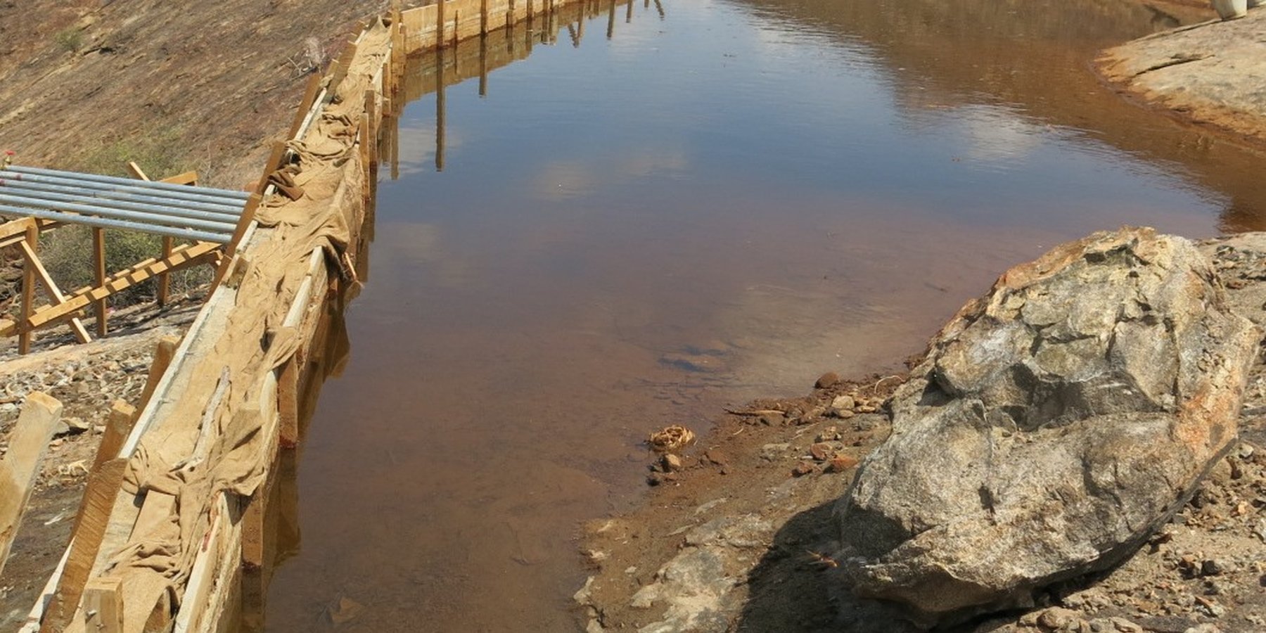
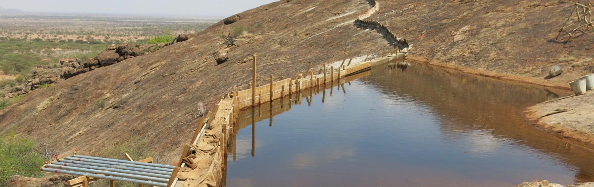
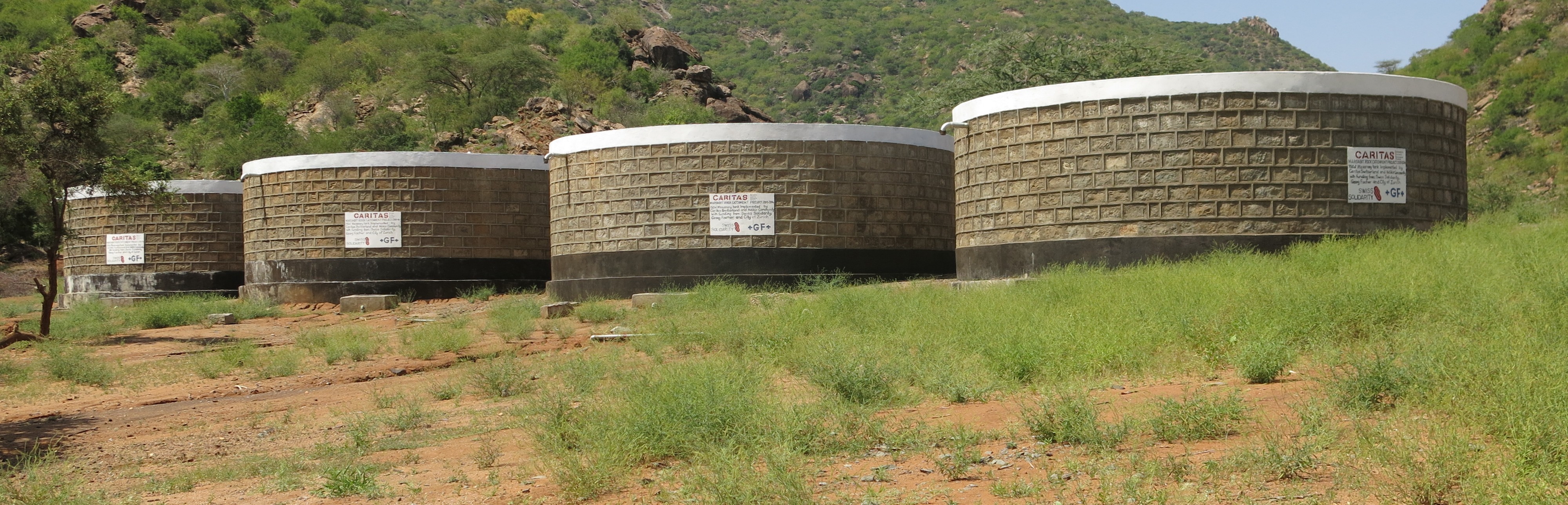
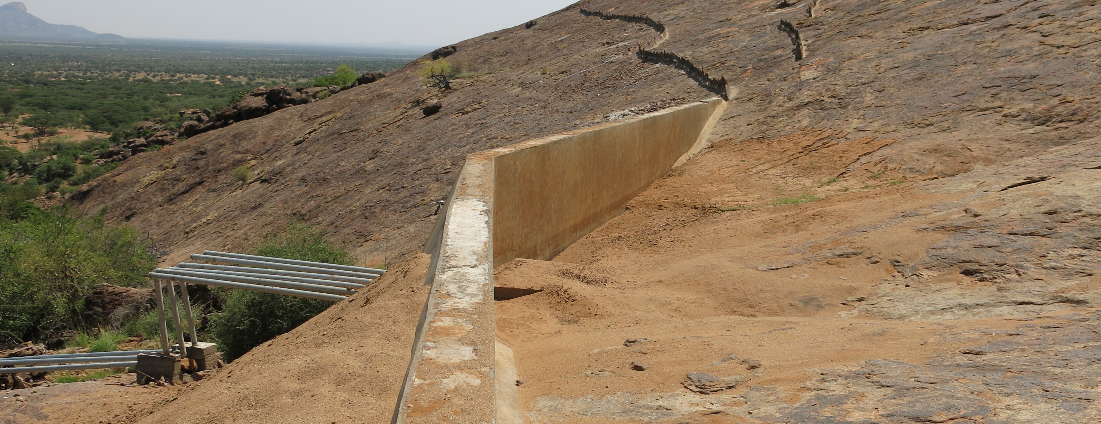
A rock catchment system is a water harvesting structure comprising a bare sloping rock surface (impounded area), a constructed concrete wall at a strategic point (weir), pipeline from the weir to the storage tank(s), storage tanks and water kiosk(s) connected to the water tanks by pipelines.
2.2 Detailed description of the Technology
Description:
The Technology is built on a gently sloping outcrop on the hillside. The bare rockface is the surface from which rainwater is harvested. A weir is constructed at a strategic point for maximum collection towards the foot of the hill. The weir dams hold harvested water in the rock catchment and channels the water through a piping system to reservoirs, generally masonry tanks, located below the hill. A weir is usually a concrete wall constructed and reinforced with iron bars to give it adequate strength to withstand the weight of the dammed water. The length, height and thickness of a weir varies with the size and the slope of the rock catchment area. On average, a weir will be 10 meters long, 2 meters high and 0.5 meters thick. At the base of the weir, an infiltration box of approximately 1 square meter is constructed and filled from the bottom with fine sand, coarse sand and gravel (in that order) for the purpose of sieving out impurities before the water reaches the tanks. Metal piping is recommended for connecting the weir to the storage tanks downhill due to the high pressure exerted by owing water. The piping distance ranges from 15 to 300 meters from the weir to the storage tanks. Provision is usually made for additional pipelines in case there is need for expansion of the system. At the bottom of the hill, masonry tanks are constructed, ranging from 100 cubic meters capacity, or greater, depending on the impounded area,
population, and available resources. The pipes join the tanks through a control chamber meant for regulating water flow into the tanks. Adjacent to the tanks are water 'kiosks' where the community draws water. To gauge how much water is issued, a meter is fitted inside the kiosk. Metering the water is a measure for accountability and control. Construction of a rock catchment system needs heavy investment in materials - cement, quarry stones, ballast, iron bars, sand, hard-core stones, water, metallic (galvanised iron) pipes and plumbing
installations. Construction of the system is labour intensive in terms of both skilled and non-skilled personnel. The main purpose of the rock catchment
system is to harvest, and store rainwater for domestic - and some livestock - use. In the case of the documented project, the benefiting communities are pastoralists who live in northern Kenya, a region characterised by chronic droughts, seasonal floods and acute water shortages. The water situation is aggravated by increasing drought frequency and severity. On the other hand, the little rain received has often been destructive downstream, cutting through roads and causing massive soil erosion due to high water velocity. During the dry periods when open water sources such as earth pans dry up, women travel long distances to search for water from hand dug shallow wells within dry seasonal riverbeds ('sand rivers').
2.3 Photos of the Technology
Media Gallery

General remarks regarding photos:
The weir which dams rock surface runoff when it rains channelling the water into the piping system which takes the water into masonry storage tanks.
2.4 Videos of the Technology
Comments, short description:
Rock catchment showing how the system harvests water and channelled down to water storage tanks.
Date:
08/12/2014
Location:
Ndikir village, Marsabit County, Kenya
Name of videographer:
Fredrick Ochieng
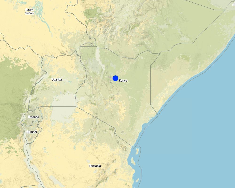
2.5 Country/ region/ locations where the Technology has been applied and which are covered by this assessment
Country:
Kenya
Region/ State/ Province:
Laisamis sub county, Marsabit County, Kenya
Further specification of location:
Implemented with three different communities in three locations, Ndikir, Manyatta Lengima and Mpagas.
Specify the spread of the Technology:
- applied at specific points/ concentrated on a small area
Comments:
The Technology was implemented with three different communities in three locations, Ndikir, Manyatta Lengima and Mpagas.
Map
×2.6 Date of implementation
Indicate year of implementation:
2015
2.7 Introduction of the Technology
Specify how the Technology was introduced:
- through projects/ external interventions
Comments (type of project, etc.):
The technology was introduced after technical assessments which looked at areas that had rock catchment potential with willing communities to participate in their construction.
3. Classification of the SLM Technology
3.1 Main purpose(s) of the Technology
- conserve ecosystem
- reduce risk of disasters
- adapt to climate change/ extremes and its impacts
- create beneficial economic impact
- create beneficial social impact
- The common hazard in the region where the Technology has been implemented is drought. The Technology aims at reducing the drought impacts among the pastoralists
3.2 Current land use type(s) where the Technology is applied

Grazing land
Extensive grazing:
- Semi-nomadic pastoralism
Animal type:
- camels
- goats
- mules and asses
- sheep
- cattle
Comments:
The pastoralists practice sedentary to semi-nomadism way of living. However, even for those who are sedentary, they do not cultivate land. They entirely rely on livestock and relief assistance.
Livestock density: The livestock owners constantly move with their livestock from one location to another.
3.4 Water supply
Water supply for the land on which the Technology is applied:
- rainfed
3.5 SLM group to which the Technology belongs
- pastoralism and grazing land management
- cross-slope measure
- water harvesting
3.6 SLM measures comprising the Technology

structural measures
- S5: Dams, pans, ponds
- S7: Water harvesting/ supply/ irrigation equipment
3.7 Main types of land degradation addressed by the Technology

soil erosion by water
- Wg: gully erosion/ gullying

water degradation
- Hs: change in quantity of surface water
- Hp: decline of surface water quality
3.8 Prevention, reduction, or restoration of land degradation
Specify the goal of the Technology with regard to land degradation:
- reduce land degradation
4. Technical specifications, implementation activities, inputs, and costs
4.1 Technical drawing of the Technology

Technical specifications (related to technical drawing):
A Rock catchment consists of the following main components:
Catchment area - vary between more or less than 100 square meters
Infiltration box - concrete box with approximately one square meter and 0.5 meters deep
Weir - a wall approximately 20 meters length, approx. 0.3-0.5 meters width, and 1.5 meters height; depending on the site the catchment can store between 150 and 700 cubic meter above the weir
Pipes - Galvanised steel pipes of varying diameters and length depending on catchment size and storage location and capacity
Tanks - tanks with varying capacities, of the same order of magnitude as the catchment storage capacity above the weir. Together, tanks and catchment can store some 10-20% of the annual precipitation falling over the rock catchment, which is enough to sustain water use during a normal year, but not during a year of exceptional water scarcity.
Here is a link where you can see a sketch of typical rock catchment: http://www.climatetechwiki.org/sites/climatetechwiki.org/files/images/extra/media_image_3_22.png
Author:
Fredrick Ocheing
Date:
13/12/2016
4.2 General information regarding the calculation of inputs and costs
Specify how costs and inputs were calculated:
- per Technology unit
Specify unit:
A unit comprises the key component of the Technology. The rock catchment technology has four components - the weir, piping, tanks and water kiosk
Specify dimensions of unit (if relevant):
N/A
Specify currency used for cost calculations:
- USD
Indicate average wage cost of hired labour per day:
15 dollars per day for skilled labour and 3 dollars per day for unskilled labour.
4.3 Establishment activities
| Activity | Timing (season) | |
|---|---|---|
| 1. | Surveys - topographical, environmental impact assessment | no specific time |
| 2. | Drawings and bill of quantities | no specific time |
| 3. | Procurement of materials | advisable should be done during the dry season when roads are passable without difficuities |
| 4. | Recruitment of artisans | no specific time |
| 5. | Start of construction works | no specific time |
| 6. | Continuous technical supervision and completion | Continuous throughout the year |
Comments:
The key activities are not generally affected by the seasonality or any other type of timing with exception of procurement, for which it is advisable to do it when roads are passable.
4.4 Costs and inputs needed for establishment
| Specify input | Unit | Quantity | Costs per Unit | Total costs per input | % of costs borne by land users | |
|---|---|---|---|---|---|---|
| Labour | Skilled labour | Days | 607.7 | 15.0 | 9115.5 | |
| Labour | Unskilled labour | Days | 1973.0 | 3.0 | 5919.0 | 40.0 |
| Construction material | Construction materials for all the four components together | 1 catchment system | 1.0 | 75407.0 | 75407.0 | |
| Total costs for establishment of the Technology | 90441.5 | |||||
| Total costs for establishment of the Technology in USD | 90441.5 | |||||
If you are unable to break down the costs in the table above, give an estimation of the total costs of establishing the Technology:
1.0
If land user bore less than 100% of costs, indicate who covered the remaining costs:
Caritas Switzerland
Comments:
The project was implemented with funding support from Caritas Switzerland to assist the community recover from the 2011 devastating drought experienced in Kenya and the entire Horn of Africa
4.5 Maintenance/ recurrent activities
| Activity | Timing/ frequency | |
|---|---|---|
| 1. | Periodic washing of tanks and scooping out of sand and silt at the weir | Twice a year |
| 2. | Repairs of broken parts - valves, pipes, taps etc.. | Through the year |
Comments:
Rock catchment systems generally have minimal maintenance and repairs
4.6 Costs and inputs needed for maintenance/ recurrent activities (per year)
| Specify input | Unit | Quantity | Costs per Unit | Total costs per input | % of costs borne by land users | |
|---|---|---|---|---|---|---|
| Other | Seasonal scooping of sand and silt from the weir | seasons/year | 2.0 | 100.0 | 200.0 | 100.0 |
| Other | Broken parts and repairs | lumpsum | 1.0 | 300.0 | 300.0 | |
| Total costs for maintenance of the Technology | 500.0 | |||||
| Total costs for maintenance of the Technology in USD | 500.0 | |||||
If you are unable to break down the costs in the table above, give an estimation of the total costs of maintaining the Technology:
1.0
4.7 Most important factors affecting the costs
Describe the most determinate factors affecting the costs:
1. Availability of parts, whether they can be bought locally or from far
2. Quality of parts
3. Extent of the system exposed to vandalism and/or destructive weather events
4. Early detection of broken/spoilt parts
5. Natural and human environment
5.1 Climate
Annual rainfall
- < 250 mm
- 251-500 mm
- 501-750 mm
- 751-1,000 mm
- 1,001-1,500 mm
- 1,501-2,000 mm
- 2,001-3,000 mm
- 3,001-4,000 mm
- > 4,000 mm
Specifications/ comments on rainfall:
The are two rainy seasons annually. The long rainy season start in March to May and short rainy season begins in October and ends in December. There has been however variations in the recent years mostly seen on rainfall variability in distribution, amounts and seasonality.
Agro-climatic zone
- arid
Amount of rainfall received annually coupled with high rates of evapotranspiration cannot sustain crop farming.
5.2 Topography
Slopes on average:
- flat (0-2%)
- gentle (3-5%)
- moderate (6-10%)
- rolling (11-15%)
- hilly (16-30%)
- steep (31-60%)
- very steep (>60%)
Landforms:
- plateau/plains
- ridges
- mountain slopes
- hill slopes
- footslopes
- valley floors
Altitudinal zone:
- 0-100 m a.s.l.
- 101-500 m a.s.l.
- 501-1,000 m a.s.l.
- 1,001-1,500 m a.s.l.
- 1,501-2,000 m a.s.l.
- 2,001-2,500 m a.s.l.
- 2,501-3,000 m a.s.l.
- 3,001-4,000 m a.s.l.
- > 4,000 m a.s.l.
Indicate if the Technology is specifically applied in:
- not relevant
Comments and further specifications on topography:
The Technology applies where there is adequate gradient of a rock surface.
5.3 Soils
If available, attach full soil description or specify the available information, e.g. soil type, soil PH/ acidity, Cation Exchange Capacity, nitrogen, salinity etc.
The technology is implemented on a rock surface.
5.4 Water availability and quality
Ground water table:
> 50 m
Availability of surface water:
poor/ none
Water quality (untreated):
poor drinking water (treatment required)
Is water salinity a problem?
Yes
Specify:
The community currently benefiting from the rock catchment have reported health problems (kidney stones) due to use of salty borehole water. The water is saline.
Is flooding of the area occurring?
Yes
Comments and further specifications on water quality and quantity:
The borehole which has been the main source of water is strongly saline and the community only use it when they can no longer find water from nearest (approximately 5 kilometres away) shallow wells. In addition, the borehole is run by diesel generator attracting high operations and maintenance costs. Earlier, breakdowns would necessitate water relief from NGOs and the government.
5.5 Biodiversity
Species diversity:
- medium
Habitat diversity:
- low
Comments and further specifications on biodiversity:
The area is covered with arid and semi arid type of vegetation mostly characterised by acacia trees and other thorny shrubs. There is limited variety of wild animals, insects and birds. This could be due to harsh climatic conditions.
5.6 Characteristics of land users applying the Technology
Sedentary or nomadic:
- Sedentary
- Semi-nomadic
Market orientation of production system:
- subsistence (self-supply)
Off-farm income:
- less than 10% of all income
Relative level of wealth:
- very poor
Individuals or groups:
- groups/ community
Level of mechanization:
- manual work
Gender:
- women
- men
Age of land users:
- children
- middle-aged
5.7 Average area of land used by land users applying the Technology
- < 0.5 ha
- 0.5-1 ha
- 1-2 ha
- 2-5 ha
- 5-15 ha
- 15-50 ha
- 50-100 ha
- 100-500 ha
- 500-1,000 ha
- 1,000-10,000 ha
- > 10,000 ha
Comments:
Not applicable. The land use system is communal and without clear demarcations from one community to another. The herders constantly move from one area and region to another in search of pasture and water resources.
5.8 Land ownership, land use rights, and water use rights
Land ownership:
- communal/ village
Land use rights:
- open access (unorganized)
- communal (organized)
Water use rights:
- open access (unorganized)
- communal (organized)
5.9 Access to services and infrastructure
health:
- poor
- moderate
- good
education:
- poor
- moderate
- good
technical assistance:
- poor
- moderate
- good
employment (e.g. off-farm):
- poor
- moderate
- good
markets:
- poor
- moderate
- good
energy:
- poor
- moderate
- good
roads and transport:
- poor
- moderate
- good
drinking water and sanitation:
- poor
- moderate
- good
financial services:
- poor
- moderate
- good
6. Impacts and concluding statements
6.1 On-site impacts the Technology has shown
Socio-economic impacts
Water availability and quality
drinking water availability
Quantity before SLM:
600 cubic meters
Quantity after SLM:
3800 cubic meters
Comments/ specify:
The community almost every year would need emergency water trucking. This is not so anymore.
drinking water quality
Quantity before SLM:
Borehole water was the only alternative source during dry season
Quantity after SLM:
Water free of salt is now available and adequate for domestic use
Comments/ specify:
They no longer use the the highly saline water which has been reported to have adverse negative health effects. The harvested water is easy to treat for microbial contamination at the household level.
water availability for livestock
Quantity before SLM:
N/A
Quantity after SLM:
N/A
Comments/ specify:
The harvested water from the rock catchment is mostly for household use.
water quality for livestock
Quantity before SLM:
N/A
Quantity after SLM:
N/A
Comments/ specify:
The harvested water from the rock catchment is mostly for household use.
Income and costs
diversity of income sources
Comments/ specify:
The time women used to spend in search of water has drastically reduced. They are now freer to engage and participating in social local networks and small businesses.
workload
Comments/ specify:
Women have benefited hugely from this Technology. Before the intervention, they would walk up to 5 kilometres in search of water for domestic use. This was particularly worse during drought or an extended dry spell as they also had to queue for many hours a day to get the water from available water points.
Other socio-economic impacts
Reduced conflicts over scarce water resources
Quantity before SLM:
N/A
Quantity after SLM:
N/A
Comments/ specify:
The pastoralist communities have in the recent decades experienced resources-based conflicts. These conflicts happen at regional, communal and family scales. The communities and families benefiting from this intervention no longer have to fight over the resource because it is adequate.
Socio-cultural impacts
health situation
Quantity before SLM:
Little water available for hygiene practices such as handwashing
Quantity after SLM:
Additional of 30 litres per day now available for good hygiene practices
Comments/ specify:
The availability of water have drastically improved hygiene practices.
community institutions
Quantity before SLM:
No properly functioning water managment committee
Quantity after SLM:
There is a vibrant and dedicated water management committee
Comments/ specify:
The implementation of the Technology has invigorated the community members and they have shown better organisation to prudently manage the water system. The management committee was existing before the technology was implemented when they managed other water sources. However, the motivation then was low coupled with low capacity to operate and maintain the water sources they had.
conflict mitigation
Quantity before SLM:
Several occurences of conflict over water
Quantity after SLM:
No more reason for conflict
Comments/ specify:
The pastoral communities have in the recent decades experienced resources-based conflicts. These conflicts happen at regional, communal and family scales. The communities and families benefiting from this intervention no longer have to fight over the resource because it is adequate.
situation of socially and economically disadvantaged groups
Quantity before SLM:
About 6 hours spent a day in search of water especially during the dry season
Quantity after SLM:
A maximum of 30 minutes spent by a woman to fetch water
Comments/ specify:
The Technology benefits women most who traditionally are socially and economically disadvantaged. Now they have more time to engage in other profitable activities. The Technology has also taken away the burden of proving water for the households, freeing them for greater social engagement
Ecological impacts
Water cycle/ runoff
harvesting/ collection of water
Comments/ specify:
Water that would normally be lost almost after it has rained is now stored and kept for future use.
surface runoff
Quantity before SLM:
All rainwater from the developed catchment was lost each time it rained.
Quantity after SLM:
About 3500 cubic meters of water is retained within the locality of the community
Comments/ specify:
There is increased control of surface runoff reducing its damaging effects on soil, vegetation and infrstrature. However, the the scale to which this is realised is low.
groundwater table/ aquifer
Quantity before SLM:
N/A
Quantity after SLM:
N/A
Comments/ specify:
The rock catchment do not in any way lead to increased groundwater recharge.
Soil
soil loss
Quantity before SLM:
N/A
Quantity after SLM:
N/A
Comments/ specify:
Due to reduced amount of water flowing from the hillside downstream, the ability of water to erode soil downstream is reduced though at very low scale.
Climate and disaster risk reduction
drought impacts
Quantity before SLM:
Water emergency supply at least two a year during the two dry spells.
Quantity after SLM:
No single water trucking done in the last two years
Comments/ specify:
Water has been the most affected livelihood commodity during drought events among the benefiting community. The impact had been acute water shortage leading to external emergency interventions. It was also happened that sometimes when food aid was provided, the community would have no water to cook. There is no longer need for water emergency in these communities.
6.2 Off-site impacts the Technology has shown
damage on public/ private infrastructure
Comments/ specify:
The high velocity water from the hills have been a constant menace in cutting or blocking roads downstream with debris. The harvesting of water has reduced the impact of this water at some sections of the hilly landscape.
Specify assessment of off-site impacts (measurements):
Some aspects of information are difficult to establish and could be best evaluated by a household survey.
6.3 Exposure and sensitivity of the Technology to gradual climate change and climate-related extremes/ disasters (as perceived by land users)
Gradual climate change
Gradual climate change
| Season | increase or decrease | How does the Technology cope with it? | |
|---|---|---|---|
| seasonal temperature | dry season | increase | very well |
| annual rainfall | decrease | moderately | |
| seasonal rainfall | dry season | increase | very well |
Climate-related extremes (disasters)
Meteorological disasters
| How does the Technology cope with it? | |
|---|---|
| local rainstorm | very well |
| local thunderstorm | very well |
Climatological disasters
| How does the Technology cope with it? | |
|---|---|
| drought | very well |
6.4 Cost-benefit analysis
How do the benefits compare with the establishment costs (from land users’ perspective)?
Short-term returns:
neutral/ balanced
Long-term returns:
very positive
How do the benefits compare with the maintenance/ recurrent costs (from land users' perspective)?
Short-term returns:
very positive
Long-term returns:
very positive
Comments:
The benefits are instantaneous as soon as the structure is completed and especially if it is during a rainy season. The technology has minimum to near zero maintenance costs which remains relatively the same in the long term. The main tasks for maintenance is seasonal removal of silt at the weir and the washing of the tanks.
6.5 Adoption of the Technology
- > 50%
If available, quantify (no. of households and/ or area covered):
This is a one Technology which is benefiting the entire community. At the time of project implementation the estimated total population was 1000 people.
Of all those who have adopted the Technology, how many did so spontaneously, i.e. without receiving any material incentives/ payments?
- 91-100%
Comments:
N/A
6.6 Adaptation
Has the Technology been modified recently to adapt to changing conditions?
No
6.7 Strengths/ advantages/ opportunities of the Technology
| Strengths/ advantages/ opportunities in the land user’s view |
|---|
|
1. Relatively low cost of operation and maintenance. 2. The technology does not require specialised technical skills for the day to day operations |
6.8 Weaknesses/ disadvantages/ risks of the Technology and ways of overcoming them
| Weaknesses/ disadvantages/ risks in the land user’s view | How can they be overcome? |
|---|---|
| 1. Relatively high initial investment cost that is unlikely to be raised by communities themselves. Without external financial support it is therefore unlikely that the system can be expanded when water needs increase. |
1. A long term plan that includes savings from fees from water sales. 2. Funds could also potentially be acquired from the county government or NGOs |
7. References and links
7.1 Methods/ sources of information
- field visits, field surveys
A field visit was done by the data compiler to meet with the land users
- interviews with land users
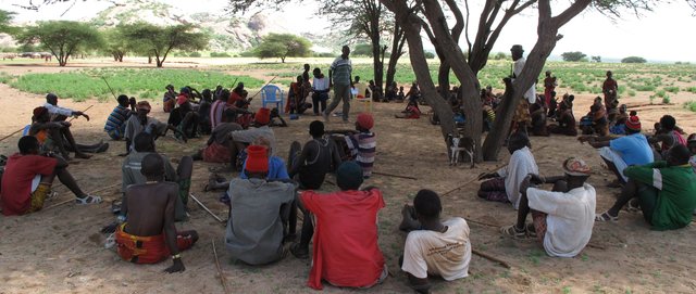
One meeting (Focused group discussion) was done with the beneficiaries of the Technology
- interviews with SLM specialists/ experts
Filling in some sections for the questionnaire required input from technical/specialist personnel who implemented the project. These are technical staff of Caritas Switzerland.
- compilation from reports and other existing documentation
reference was made on technical documents of the project - proposals, technical reports (narrative, photos, videos).
When were the data compiled (in the field)?
21/09/2016
7.2 References to available publications
Title, author, year, ISBN:
A Handbook of gravity-flow water systems for small communities; Thomas D. Jordan Junior; 1980; 978 0 94668 850 0
Available from where? Costs?
CACH office library, Nairobi
7.3 Links to relevant online information
Title/ description:
Rock Catchments for Community Water Supply in Eastern Equatoria State, South Sudan
URL:
http://waterconsortium.ch/wp-content/uploads/2016/09/Poster_Rock_Catchments_Caritas_South_Sudan_2016.pdf
Title/ description:
Adopting locally appropriate WASH solutions: a case study of rock catchment systems in South Sudan
URL:
http://wedc.lboro.ac.uk/resources/conference/37/Leclert-1935.pdf
Links and modules
Expand all Collapse allLinks
Partnership with beneficiary communities in project implementation [Kenya]
The approach focuses on community engagement on a partnership basis. The model is a departure from the traditional approaches where the community mostly is reduced to being a beneficiary of project services without substantive responsibility.
- Compiler: Fredrick Ochieng
Modules
No modules