Biologische Weidewirtschaft von Kühen in einer Tierarche [Switzerland]
- Creation:
- Update:
- Compiler: Julian Meier
- Editor: Aline Wicki
- Reviewers: Hanspeter Liniger, Rima Mekdaschi Studer
Tierarche
technologies_5837 - Switzerland
View sections
Expand all Collapse all1. General information
1.2 Contact details of resource persons and institutions involved in the assessment and documentation of the Technology
land user:
U. M.
Switzerland
1.3 Conditions regarding the use of data documented through WOCAT
The compiler and key resource person(s) accept the conditions regarding the use of data documented through WOCAT:
Yes
1.4 Declaration on sustainability of the described Technology
Is the Technology described here problematic with regard to land degradation, so that it cannot be declared a sustainable land management technology?
Yes
Comments:
Organische Böden: Organisches Material wird abgebaut durch die Nutzung.
2. Description of the SLM Technology
2.1 Short description of the Technology
Definition of the Technology:
Es handelt sich um eine Weide, welche zu einer Tierarche gehört, dies bedeutet, dass die Tiere nicht mehr in der Nutzung stehen. Der Boden ist geprägt durch einen 25 bis 80 cm organischen Oberboden (ca. 20% organisches Materiel), nachfolgend ist meist eine wasserstauende Tonschicht zu finden.
2.2 Detailed description of the Technology
Description:
Es handelt sich um eine Weide, welche zu einer Tierarche gehört, dies bedeutet, dass die Tiere nicht mehr in der Nutzung stehen. Der Boden ist geprägt durch einen 25 bis 80 cm organischen Oberboden (ca. 20% organisches Material), nachfolgend ist meist eine wasserstauende Tonschicht zu finden. Die Kühe leben fern von deren Nutzung, finanziert durch Spendengelder.
Die beschriebene Weide umfasst ca. 2 Hektaren. Die Parzelle hat eine Länge von ungefähr 220 Metern und eine Breite von ungefähr 95 Metern. Der Boden ist unterschiedlich mächtig. Die Neigung ist über den Perimeter nahezu null Grad.
Das hier beschriebene System besteht aus einer Drainageanlage. Diese sorgt dafür, dass das Gras auf der Weide unter guten Bedingungen wachsen kann. Die heutige Kuhweide wurde vor 2017 als Fruchtfolge-Kulturland genutzt. Das vom Landwirt betriebene Weidesystem schont den Boden, da die Bearbeitung, wie Pflügen oder Grubbern, wie sie zuvor geschah, entfällt. Insbesondere der Abbau des organische (>10%) A-Horizontes könnte diese Nutzung verlangsamen.
Das System wurde durch den Landwirt bestimmt und scheint daher für ihn adäquat zu sein. Das Projekt der «Tierarche Seeland» wurde internistisch vom Landwirt selbst initiiert.
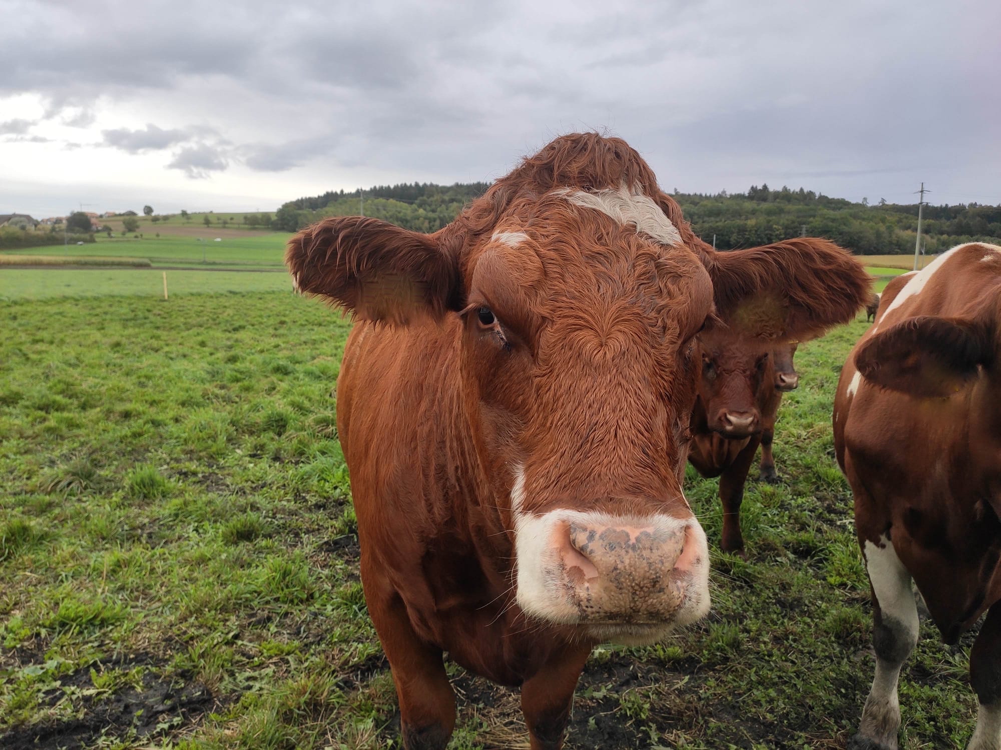
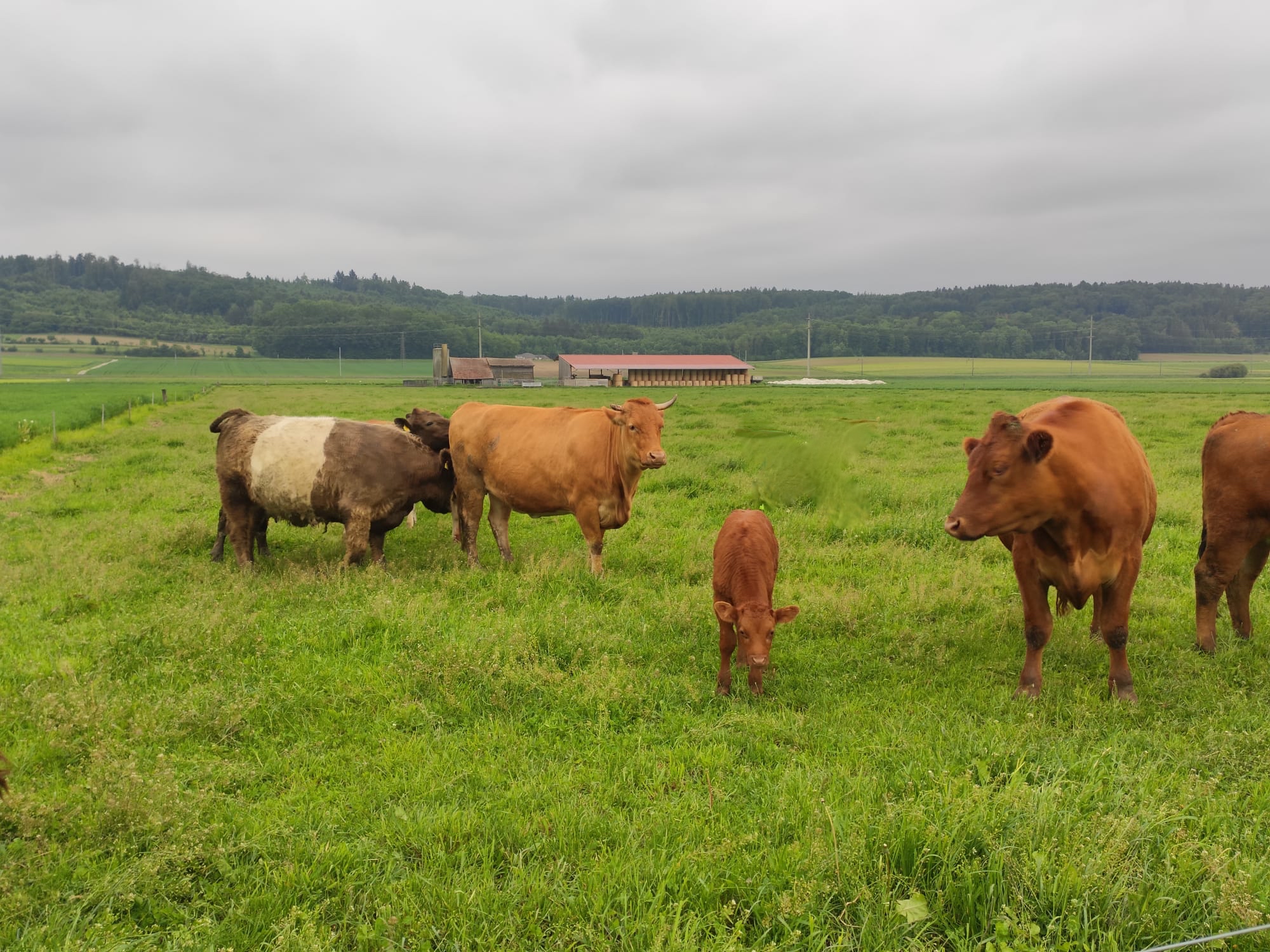
2.3 Photos of the Technology
Media Gallery
2.5 Country/ region/ locations where the Technology has been applied and which are covered by this assessment
Country:
Switzerland
Region/ State/ Province:
Bern
Further specification of location:
Kallnach
Specify the spread of the Technology:
- applied at specific points/ concentrated on a small area
Is/are the technology site(s) located in a permanently protected area?
No
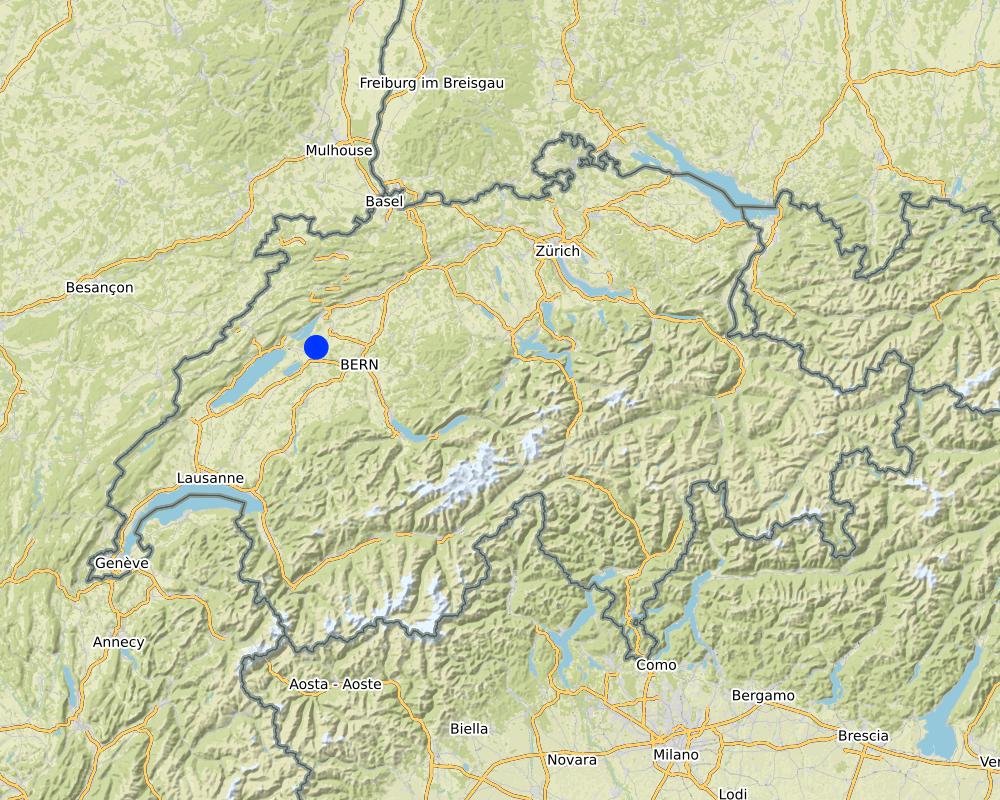
Map
×2.6 Date of implementation
Indicate year of implementation:
2017
If precise year is not known, indicate approximate date:
- less than 10 years ago (recently)
2.7 Introduction of the Technology
Specify how the Technology was introduced:
- through land users' innovation
Comments (type of project, etc.):
Die Tierarche entstand durch die Eigeninitiative des Landwirtes
3. Classification of the SLM Technology
3.1 Main purpose(s) of the Technology
- reduce, prevent, restore land degradation
3.2 Current land use type(s) where the Technology is applied
Land use mixed within the same land unit:
No

Grazing land
Extensive grazing:
- Ranching
- Kühe ohne landwirtschaftliche Nutzung (Ausnahme organischer Dünger)
Is integrated crop-livestock management practiced?
No
Products and services:
- manure as fertilizer/ energy production
- Tierwohl
Species:
cattle - non-dairy working
Count:
15
3.3 Has land use changed due to the implementation of the Technology?
Has land use changed due to the implementation of the Technology?
- No (Continue with question 3.4)
3.4 Water supply
Water supply for the land on which the Technology is applied:
- rainfed
Comments:
Es besteht ein Drainage-System
3.5 SLM group to which the Technology belongs
- pastoralism and grazing land management
- water diversion and drainage
3.6 SLM measures comprising the Technology

agronomic measures
- A1: Vegetation/ soil cover
- A2: Organic matter/ soil fertility
- A3: Soil surface treatment
- A6: Residue management
A3: Differentiate tillage systems:
A 3.1: No tillage
A6: Specify residue management:
A 6.2: grazed

structural measures
- S3: Graded ditches, channels, waterways

management measures
- M1: Change of land use type
3.7 Main types of land degradation addressed by the Technology

soil erosion by wind
- Et: loss of topsoil

chemical soil deterioration
- Cn: fertility decline and reduced organic matter content (not caused by erosion)

physical soil deterioration
- Pc: compaction
- Pw: waterlogging
- Ps: subsidence of organic soils, settling of soil

other
Specify:
Stauwasser aufgrund der stauenden Tonschicht im Unterboden.
3.8 Prevention, reduction, or restoration of land degradation
Specify the goal of the Technology with regard to land degradation:
- reduce land degradation
- adapt to land degradation
4. Technical specifications, implementation activities, inputs, and costs
4.1 Technical drawing of the Technology
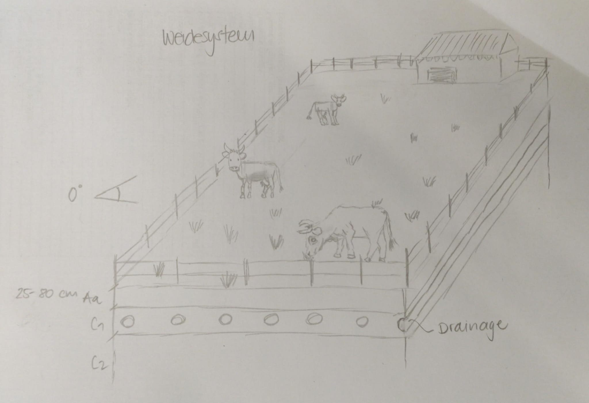
Technical specifications (related to technical drawing):
Weidegrösse: 2ha
Tierpopulaton: 15 Stück nicht landwirtschaftlich genutztes Rindvieh
Weidedauer: 9 Monate im Jahr
Neigung: 0°
Drainage: Ja
Bodenhorizontabfolge: A-C
A-Horizont: 25-80 cm / anmoorig (>10% organisches Substanz)
C-Horizont: tonige Stauschicht, mit zunehmender Tiefe mehr Schluff
Bodentyp: Braunerde-Pseudogley
Author:
Aline Wicki / Julian Meier
Date:
30/10/2020
4.2 General information regarding the calculation of inputs and costs
Specify how costs and inputs were calculated:
- per Technology area
Indicate size and area unit:
2 Hektaren
other/ national currency (specify):
CHF
If relevant, indicate exchange rate from USD to local currency (e.g. 1 USD = 79.9 Brazilian Real): 1 USD =:
0.92
Indicate average wage cost of hired labour per day:
186
4.7 Most important factors affecting the costs
Describe the most determinate factors affecting the costs:
Es wurde für diesen Beschrieb keine Kostenrechnung vorgenommen, da ein Status-Quo beschrieben und keine Technologieveränderung vorgenommen wurde. Ausserdem lagen die Daten für die genaue Berechnung der Kosten für die Drainagen nicht vor.
5. Natural and human environment
5.1 Climate
Annual rainfall
- < 250 mm
- 251-500 mm
- 501-750 mm
- 751-1,000 mm
- 1,001-1,500 mm
- 1,501-2,000 mm
- 2,001-3,000 mm
- 3,001-4,000 mm
- > 4,000 mm
Specify average annual rainfall (if known), in mm:
957.00
Specifications/ comments on rainfall:
Für 2019, gemessen in Fräschels
Indicate the name of the reference meteorological station considered:
MeteoSchweiz, Fräschels
Agro-climatic zone
- sub-humid
Durchschnittlich 7, 4 Grad Celsius, min. 2 Grad Celsius im Januar, max. 23 Grad Celsius im Juli - Messstation Fräschels
5.2 Topography
Slopes on average:
- flat (0-2%)
- gentle (3-5%)
- moderate (6-10%)
- rolling (11-15%)
- hilly (16-30%)
- steep (31-60%)
- very steep (>60%)
Landforms:
- plateau/plains
- ridges
- mountain slopes
- hill slopes
- footslopes
- valley floors
Altitudinal zone:
- 0-100 m a.s.l.
- 101-500 m a.s.l.
- 501-1,000 m a.s.l.
- 1,001-1,500 m a.s.l.
- 1,501-2,000 m a.s.l.
- 2,001-2,500 m a.s.l.
- 2,501-3,000 m a.s.l.
- 3,001-4,000 m a.s.l.
- > 4,000 m a.s.l.
Indicate if the Technology is specifically applied in:
- not relevant
5.3 Soils
Soil depth on average:
- very shallow (0-20 cm)
- shallow (21-50 cm)
- moderately deep (51-80 cm)
- deep (81-120 cm)
- very deep (> 120 cm)
Soil texture (topsoil):
- medium (loamy, silty)
Soil texture (> 20 cm below surface):
- medium (loamy, silty)
- fine/ heavy (clay)
Topsoil organic matter:
- high (>3%)
5.4 Water availability and quality
Ground water table:
< 5 m
Availability of surface water:
good
Water quality (untreated):
poor drinking water (treatment required)
Water quality refers to:
surface water
Is water salinity a problem?
No
Is flooding of the area occurring?
No
Comments and further specifications on water quality and quantity:
Stauwasser kann zum Problem werden, scheint aber gemäss dem Landwirten auf der Weide keine grossen Einflüsse zu haben.
5.5 Biodiversity
Species diversity:
- low
Habitat diversity:
- medium
5.6 Characteristics of land users applying the Technology
Sedentary or nomadic:
- Sedentary
Market orientation of production system:
- commercial/ market
Off-farm income:
- less than 10% of all income
Relative level of wealth:
- average
Individuals or groups:
- individual/ household
Level of mechanization:
- mechanized/ motorized
Gender:
- women
- men
Age of land users:
- middle-aged
5.7 Average area of land used by land users applying the Technology
- < 0.5 ha
- 0.5-1 ha
- 1-2 ha
- 2-5 ha
- 5-15 ha
- 15-50 ha
- 50-100 ha
- 100-500 ha
- 500-1,000 ha
- 1,000-10,000 ha
- > 10,000 ha
Is this considered small-, medium- or large-scale (referring to local context)?
- large-scale
Comments:
29 Hektaren beträgt die Gesamtbewirtschaftungsfläche.
5.8 Land ownership, land use rights, and water use rights
Land ownership:
- communal/ village
- individual, titled
Land use rights:
- leased
- individual
Water use rights:
- communal (organized)
Are land use rights based on a traditional legal system?
Yes
Specify:
Schweizer Recht, BV Art. 26 Eigentumsrecht
Pachtreglement Burgergemeinde Kallnach
5.9 Access to services and infrastructure
health:
- poor
- moderate
- good
education:
- poor
- moderate
- good
technical assistance:
- poor
- moderate
- good
employment (e.g. off-farm):
- poor
- moderate
- good
markets:
- poor
- moderate
- good
energy:
- poor
- moderate
- good
roads and transport:
- poor
- moderate
- good
drinking water and sanitation:
- poor
- moderate
- good
financial services:
- poor
- moderate
- good
6. Impacts and concluding statements
6.1 On-site impacts the Technology has shown
Socio-economic impacts
Production
crop production
risk of production failure
product diversity
land management
Water availability and quality
irrigation water availability
demand for irrigation water
Income and costs
expenses on agricultural inputs
farm income
workload
Ecological impacts
Water cycle/ runoff
excess water drainage
evaporation
Soil
soil cover
soil loss
soil compaction
soil organic matter/ below ground C
Biodiversity: vegetation, animals
Vegetation cover
habitat diversity
pest/ disease control
Climate and disaster risk reduction
drought impacts
impacts of cyclones, rain storms
emission of carbon and greenhouse gases
wind velocity
Specify assessment of on-site impacts (measurements):
Wichtig: Da keine neuen Technologien in Rahmen dieses Projektes implementiert wurden, handelt es sich um einen Abgliech mit der durchschnittlichen Nutzung innerhalb eines 28,4 Hektaren grossen Perimeters in Kallnach BE. Die Einschätzungen erfolgten aufgrund von Beobachtungen im Feld, Bodenproben und Befragungen der Landwirte.
6.2 Off-site impacts the Technology has shown
water availability
groundwater/ river pollution
impact of greenhouse gases
Specify assessment of off-site impacts (measurements):
Wichtig: Da keine neuen Technologien in Rahmen dieses Projektes implementiert wurden, handelt es sich um einen Abgliech mit der durchschnittlichen Nutzung innerhalb eines 28,4 Hektaren grossen Perimeters in Kallnach BE. Die Einschätzungen erfolgten aufgrund von Beobachtungen im Feld, Bodenproben und Befragungen der Landwirte.
6.3 Exposure and sensitivity of the Technology to gradual climate change and climate-related extremes/ disasters (as perceived by land users)
Gradual climate change
Gradual climate change
| Season | increase or decrease | How does the Technology cope with it? | |
|---|---|---|---|
| annual temperature | increase | moderately | |
| seasonal temperature | winter | increase | well |
| seasonal temperature | spring | increase | well |
| seasonal temperature | summer | increase | moderately |
| seasonal temperature | autumn | increase | well |
Climate-related extremes (disasters)
Meteorological disasters
| How does the Technology cope with it? | |
|---|---|
| local rainstorm | not well |
Climatological disasters
| How does the Technology cope with it? | |
|---|---|
| heatwave | moderately |
| drought | moderately |
Other climate-related consequences
Other climate-related consequences
| How does the Technology cope with it? | |
|---|---|
| extended growing period | well |
6.4 Cost-benefit analysis
How do the benefits compare with the establishment costs (from land users’ perspective)?
Short-term returns:
negative
Long-term returns:
slightly positive
How do the benefits compare with the maintenance/ recurrent costs (from land users' perspective)?
Short-term returns:
slightly negative
Long-term returns:
slightly negative
6.5 Adoption of the Technology
- 1-10%
Of all those who have adopted the Technology, how many did so spontaneously, i.e. without receiving any material incentives/ payments?
- 91-100%
6.6 Adaptation
Has the Technology been modified recently to adapt to changing conditions?
No
6.7 Strengths/ advantages/ opportunities of the Technology
| Strengths/ advantages/ opportunities in the land user’s view |
|---|
| Adaption an das Nässe-/Stauwasserproblem |
| Verbesserter Bodenschutz durch extensivere Nutzung |
| Schopf/Unterstand als Stall bereits vorhanden |
| Strengths/ advantages/ opportunities in the compiler’s or other key resource person’s view |
|---|
| Adaption an das Nässe-/Stauwasserproblem |
| Verbesserter Bodenschutz durch extensivere Nutzung |
| Verbesserte Bodenbedeckung, dadurch weniger Kohlenstofffreisetzung. |
6.8 Weaknesses/ disadvantages/ risks of the Technology and ways of overcoming them
| Weaknesses/ disadvantages/ risks in the land user’s view | How can they be overcome? |
|---|---|
| Verlust von gutem Ackerland durch Weide aufgrund der Dauerweide | Standortwechsel |
| Weaknesses/ disadvantages/ risks in the compiler’s or other key resource person’s view | How can they be overcome? |
|---|---|
| Enkommensverlust im Vergleich zu den Akcerbauflächen in der Nachbarschaft | Einnahmen durch Patenschaften in der Tierarche. |
7. References and links
7.1 Methods/ sources of information
- field visits, field surveys
Meherer Feldbegehungen
20 Bohrpunkte im Perimeter Kallnach (28,4 ha)
- interviews with land users
Befragung des Landwirten im Rahmen des Bodenverbesserungsprojekt Seeland (BOVE) und Masterarbeit
- compilation from reports and other existing documentation
Recherche
When were the data compiled (in the field)?
01/05/2020
Comments:
Mai bis Oktober 2020 in mehreren Begehungen
7.2 References to available publications
Title, author, year, ISBN:
Wirz Set Handbücher, Agridea, 2020, ISBN: 978-3-7245-2369-7 (Handbuch Betrieb und Familie, Handbuch Pflanzen und Tiere)
Available from where? Costs?
44 CHF, Reinhard dt Verlag
7.3 Links to relevant online information
Title/ description:
Meteo Schweiz
URL:
https://map.geo.admin.ch/?lang=de&topic=ech&bgLayer=ch.swisstopo.pixelkarte-farbe&layers=ch.swisstopo.zeitreihen,ch.bfs.gebaeude_wohnungs_register,ch.bav.haltestellen-oev,ch.swisstopo.swisstlm3d-wanderwege&layers_opacity=1,1,1,0.8&layers_visibility=false,false,false,false&layers_timestamp=18641231,,,&E=2581786.92&N=1206881.37&zoom=6.6594771435586075
Title/ description:
Swisstopo
URL:
https://map.geo.admin.ch/?lang=de&topic=ech&bgLayer=ch.swisstopo.pixelkarte-farbe&layers=ch.swisstopo.zeitreihen,ch.bfs.gebaeude_wohnungs_register,ch.bav.haltestellen-oev,ch.swisstopo.swisstlm3d-wanderwege&layers_opacity=1,1,1,0.8&layers_visibility=false,false,false,false&layers_timestamp=18641231,,,&E=2581786.92&N=1206881.37&zoom=6.6594771435586075
Links and modules
Expand all Collapse allLinks
No links
Modules
No modules