Rainwater Harvesting for Olive Production [Palestine, State of]
- Creation:
- Update:
- Compiler: Joren Verbist
- Editor: –
- Reviewers: William Critchley, Rima Mekdaschi Studer
technologies_6437 - Palestine, State of
View sections
Expand all Collapse all1. General information
1.2 Contact details of resource persons and institutions involved in the assessment and documentation of the Technology
Key resource person(s)
Research Associate – Spatio-temporal assessment – Resilient Agrosilvopastoral Systems (RASP) – Restoration Initiative on Dryland Ecosystems (RIDE):
Haddad Mira
International Center of Agriculture Research in the Dry Areas (ICARDA)
Jordan
Scientist, Soil and Water Conservation – Resilient Agrosilvopastoral Systems (RASP):
Strohmeier Stefan
International Center of Agriculture Research in the Dry Areas (ICARDA); Institute for Soil Physics and Rural Water Management (SoPhy) – University of Natural Resources and Life Sciences (BOKU) (Vienna, Austria)
Austria
Research Team Leader – Soils, Waters, and Agronomy:
Nangia Vinay
International Center of Agriculture Research in the Dry Areas (ICARDA)
Morocco
Senior Natural Resources Economist – Resilient Agrosilvopastoral Systems (RASP) – Social, Economic, and Policy Team (SEPT):
Dhehibi Boubaker
International Center of Agriculture Research in the Dry Areas (ICARDA)
Tunisia
Name of project which facilitated the documentation/ evaluation of the Technology (if relevant)
ICARDA Institutional Knowledge Management InitiativeName of the institution(s) which facilitated the documentation/ evaluation of the Technology (if relevant)
International Center for Agricultural Research in the Dry Areas (ICARDA) - Lebanon1.3 Conditions regarding the use of data documented through WOCAT
The compiler and key resource person(s) accept the conditions regarding the use of data documented through WOCAT:
Yes
1.4 Declaration on sustainability of the described Technology
Is the Technology described here problematic with regard to land degradation, so that it cannot be declared a sustainable land management technology?
No
2. Description of the SLM Technology
2.1 Short description of the Technology
Definition of the Technology:
Microcatchment water harvesting captures, stores and allows safe overflow of excess surface runoff collected during heavy rainfall events. The intercepted and deep-infiltrated water enhances soil moisture at/around the microcatchment structure. This eventually boosts plant productivity in dry areas, mitigates land degradation, and benefits the local farming communities’ livelihoods
2.2 Detailed description of the Technology
Description:
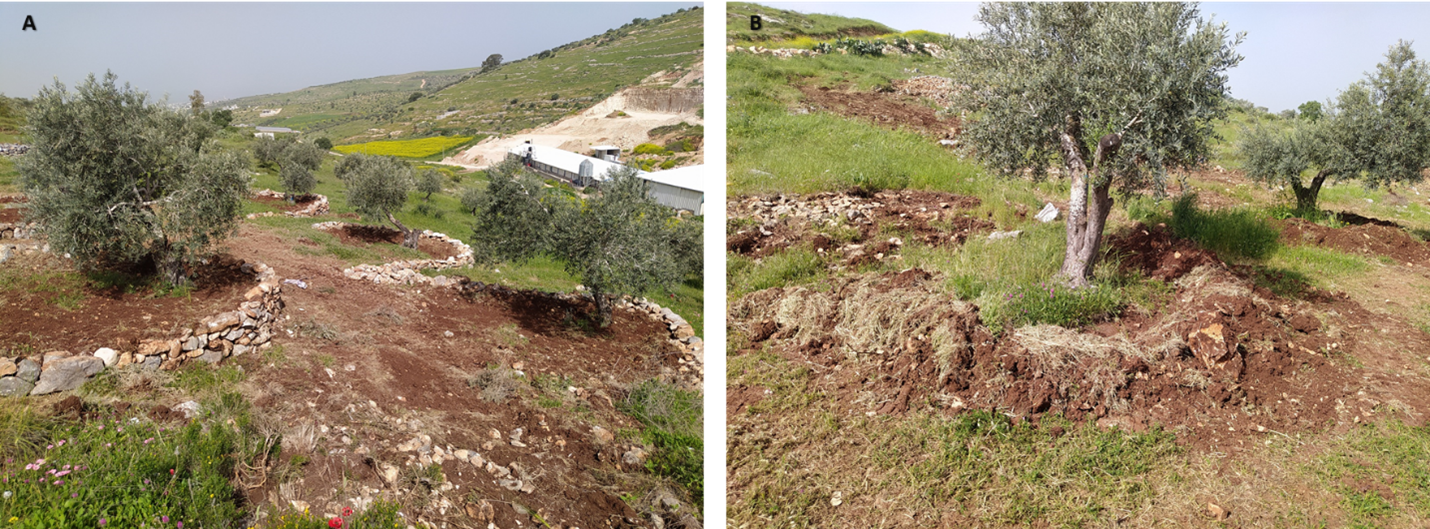
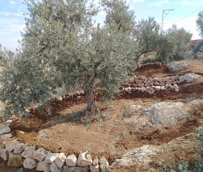
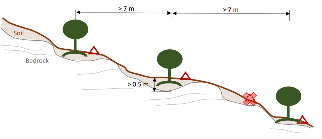
In Palestine, rainfed olives are traditionally cultivated within undulating landscapes with an average annual precipitation ranging between 400 and 700 mm. Olive trees are well known for their resilience to droughts. However, degraded and steeply sloping areas have limited water infiltration and storage capacity: a large proportion of rain forms surface runoff, further speeding up land degradation through erosion and the removal of fertile topsoil, leading to decreased soil health and productivity. The International Center of Agriculture Research in Dry Areas (ICARDA) among others, recognised these issues and superimposed microcatchment water harvesting structures on existing rainfed olive trees in marginal and degraded drylands of Palestine. This technique aims to improve yields by increasing soil moisture through capturing runoff and enhancing infiltration. Thereby, it also decreases the potential for land degradation through surface runoff. This has positive impacts on the local land users and land owners. These are often considered marginalised groups because they lack access to off-farm work and finance to invest in their farms. Additionally, these farmers are directly experiencing the negative impacts of climate change, such as more frequent droughts which can be linked to declining yields, and decreasing farm income. Depending on local climate, topographic and soil conditions, olive trees are usually spaced 5-10 meters apart to avoid competition for water.
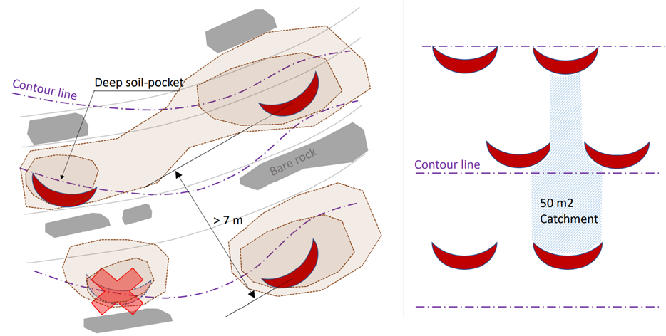
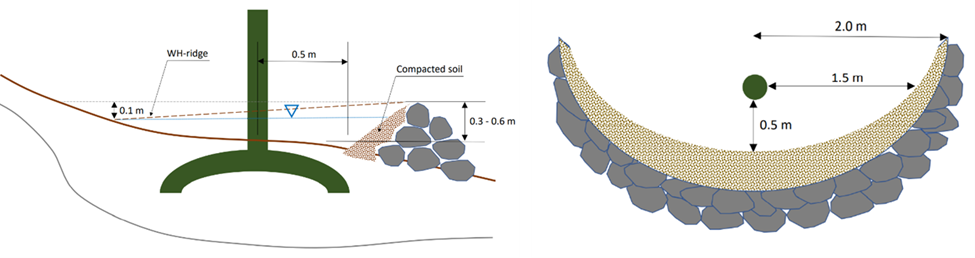
The land is first surveyed and then the microcatchment water harvesting structures (technically termed “semi-circular bunds”) are designed with the tips of the structures on the contour. They are constructed around 0.5 meters downslope of each olive tree in a semi-circle of around 4 meters diameter. The structures are created through stone foundation and bunds topped with a compacted soil layer. The height of the structures varies between 0.3 meters and 1.2 meters. As a first step, stones are placed and fixed in a semi-circular shape. Secondly, the soil inside the structure is slightly levelled. Thirdly, more stones are placed to heighten the bunds. Lastly, excavated and surround soil is put over the stones and thoroughly compacted. The estimation of establishment cost is 7 USD per meter of bund, implying a total cost of approximately 7000 USD per hectare.
The life-duration of the water harvesting system implemented in highly sloping areas, is estimated at 15 years with yearly maintenance cost estimated at 3 USD per tree – 300 USD per hectare. Without maintenance, the life-cycle of the system will be less.
Land users appreciate the technology because it improves their olive yields and thus income. They state that the topsoil maintained in situ, and the improved soil moisture, have positive effects on their harvest. Land users also acknowledge that implementing and maintaining increases the workload. Nevertheless, due to the local material requirements, the costs are low and thus perceived as positive.
Data presented in this documentation are partly made available under the project 'Testing and Out-scaling in situ Water Harvesting Technologies in Palestine' led by ICARDA in collaboration with the Applied Research Institute Jerusalem, Palestinian Ministry of Agriculture, and National Agricultural Research Centre in Palestine. The project is under the Food and Agriculture Organization of the United Nations (FAO) – a regional project “Implementing the 2030 Agenda for water efficiency/productivity and water sustainability in NENA countries” directly under the Regional Water Scarcity Initiative. The Swedish International Development Cooperation Agency funded the project.
2.3 Photos of the Technology
Media Gallery

2.5 Country/ region/ locations where the Technology has been applied and which are covered by this assessment
Country:
Palestine, State of
Specify the spread of the Technology:
- evenly spread over an area
If precise area is not known, indicate approximate area covered:
- 0.1-1 km2
Is/are the technology site(s) located in a permanently protected area?
No
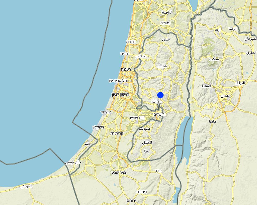
Map
×2.6 Date of implementation
Indicate year of implementation:
2021
2.7 Introduction of the Technology
Specify how the Technology was introduced:
- during experiments/ research
- through projects/ external interventions
3. Classification of the SLM Technology
3.1 Main purpose(s) of the Technology
- improve production
- reduce, prevent, restore land degradation
- adapt to climate change/ extremes and its impacts
- create beneficial economic impact
3.2 Current land use type(s) where the Technology is applied
Land use mixed within the same land unit:
No

Cropland
- Tree and shrub cropping
Tree and shrub cropping - Specify crops:
- olive
Is intercropping practiced?
No
Is crop rotation practiced?
No
3.3 Has land use changed due to the implementation of the Technology?
Has land use changed due to the implementation of the Technology?
- No (Continue with question 3.4)
3.4 Water supply
Water supply for the land on which the Technology is applied:
- rainfed
Comments:
The area is rainfed and the water for crop use in enhanced due to rain water harvesting.
3.5 SLM group to which the Technology belongs
- forest plantation management
- cross-slope measure
- water harvesting
3.6 SLM measures comprising the Technology

structural measures
- S2: Bunds, banks
- S7: Water harvesting/ supply/ irrigation equipment
3.7 Main types of land degradation addressed by the Technology

soil erosion by water
- Wt: loss of topsoil/ surface erosion
- Wg: gully erosion/ gullying
- Wm: mass movements/ landslides

soil erosion by wind
- Et: loss of topsoil
3.8 Prevention, reduction, or restoration of land degradation
Specify the goal of the Technology with regard to land degradation:
- prevent land degradation
- reduce land degradation
4. Technical specifications, implementation activities, inputs, and costs
4.1 Technical drawing of the Technology
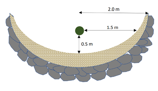
Technical specifications (related to technical drawing):
Microcatchment rainwater harvesting design, with detailed cross-sectional (left) and top (right) views; definition of dimensions
Date:
2022
Technical specifications (related to technical drawing):
Microcatchment rainwater harvesting design in hillslope direction; definition of spacing constrained by the local ‘soil pocket’ hillslope pattern.
Date:
2022
Technical specifications (related to technical drawing):
Microcatchment rainwater harvesting design from a top view; definition of minimum microcatchment areas contributing to the rainwater harvesting pits.
Date:
2022
Technical specifications (related to technical drawing):
Microcatchment rainwater harvesting design, with detailed cross-sectional (left) and top (right) views; definition of dimensions.
Date:
2022
4.2 General information regarding the calculation of inputs and costs
Specify how costs and inputs were calculated:
- per Technology area
Indicate size and area unit:
1 Hectare
Specify currency used for cost calculations:
- USD
4.3 Establishment activities
| Activity | Timing (season) | |
|---|---|---|
| 1. | Field survey for contours | |
| 2. | Place Stones | |
| 3. | Soil Removal | |
| 4. | Stone bund around tree | |
| 5. | Stone bund topped with excavated soil |
4.4 Costs and inputs needed for establishment
If you are unable to break down the costs in the table above, give an estimation of the total costs of establishing the Technology:
7000.0
If land user bore less than 100% of costs, indicate who covered the remaining costs:
The project met the total costs for establishment.
4.5 Maintenance/ recurrent activities
| Activity | Timing/ frequency | |
|---|---|---|
| 1. | Incidental repairs |
4.6 Costs and inputs needed for maintenance/ recurrent activities (per year)
If you are unable to break down the costs in the table above, give an estimation of the total costs of maintaining the Technology:
300.0
Comments:
The land users are expected to continue to carry out maintenance themselves.
5. Natural and human environment
5.1 Climate
Annual rainfall
- < 250 mm
- 251-500 mm
- 501-750 mm
- 751-1,000 mm
- 1,001-1,500 mm
- 1,501-2,000 mm
- 2,001-3,000 mm
- 3,001-4,000 mm
- > 4,000 mm
Agro-climatic zone
- semi-arid
5.2 Topography
Slopes on average:
- flat (0-2%)
- gentle (3-5%)
- moderate (6-10%)
- rolling (11-15%)
- hilly (16-30%)
- steep (31-60%)
- very steep (>60%)
Landforms:
- plateau/plains
- ridges
- mountain slopes
- hill slopes
- footslopes
- valley floors
Altitudinal zone:
- 0-100 m a.s.l.
- 101-500 m a.s.l.
- 501-1,000 m a.s.l.
- 1,001-1,500 m a.s.l.
- 1,501-2,000 m a.s.l.
- 2,001-2,500 m a.s.l.
- 2,501-3,000 m a.s.l.
- 3,001-4,000 m a.s.l.
- > 4,000 m a.s.l.
Indicate if the Technology is specifically applied in:
- not relevant
5.3 Soils
Soil depth on average:
- very shallow (0-20 cm)
- shallow (21-50 cm)
- moderately deep (51-80 cm)
- deep (81-120 cm)
- very deep (> 120 cm)
Soil texture (topsoil):
- medium (loamy, silty)
Soil texture (> 20 cm below surface):
- medium (loamy, silty)
Topsoil organic matter:
- medium (1-3%)
- low (<1%)
5.4 Water availability and quality
Ground water table:
5-50 m
Availability of surface water:
poor/ none
Water quality (untreated):
for agricultural use only (irrigation)
Water quality refers to:
surface water
Is water salinity a problem?
No
Is flooding of the area occurring?
No
5.5 Biodiversity
Species diversity:
- low
Habitat diversity:
- low
5.6 Characteristics of land users applying the Technology
Sedentary or nomadic:
- Sedentary
Market orientation of production system:
- mixed (subsistence/ commercial)
Off-farm income:
- less than 10% of all income
Relative level of wealth:
- very poor
- poor
Individuals or groups:
- individual/ household
- groups/ community
Level of mechanization:
- manual work
- mechanized/ motorized
Gender:
- men
Age of land users:
- youth
- middle-aged
- elderly
5.7 Average area of land used by land users applying the Technology
- < 0.5 ha
- 0.5-1 ha
- 1-2 ha
- 2-5 ha
- 5-15 ha
- 15-50 ha
- 50-100 ha
- 100-500 ha
- 500-1,000 ha
- 1,000-10,000 ha
- > 10,000 ha
Is this considered small-, medium- or large-scale (referring to local context)?
- small-scale
5.8 Land ownership, land use rights, and water use rights
Land ownership:
- individual, not titled
- individual, titled
Land use rights:
- individual
Water use rights:
- communal (organized)
Are land use rights based on a traditional legal system?
Yes
5.9 Access to services and infrastructure
health:
- poor
- moderate
- good
education:
- poor
- moderate
- good
technical assistance:
- poor
- moderate
- good
employment (e.g. off-farm):
- poor
- moderate
- good
markets:
- poor
- moderate
- good
energy:
- poor
- moderate
- good
roads and transport:
- poor
- moderate
- good
drinking water and sanitation:
- poor
- moderate
- good
financial services:
- poor
- moderate
- good
6. Impacts and concluding statements
6.1 On-site impacts the Technology has shown
Socio-economic impacts
Production
crop production
crop quality
risk of production failure
Comments/ specify:
Improved soil moisture provides resilience for droughts, reducing failure risk
land management
Comments/ specify:
Not damaging the bunds may hinder land management
Income and costs
expenses on agricultural inputs
Comments/ specify:
Inputs for repair and implementation is required
farm income
Comments/ specify:
Because soil moisture is increased, yield is as well and risk is decreased
workload
Comments/ specify:
Building and repairing the bunds requires labour
Socio-cultural impacts
food security/ self-sufficiency
SLM/ land degradation knowledge
Comments/ specify:
Local farmers were included in the process, improving their knowledge
situation of socially and economically disadvantaged groups
Ecological impacts
Water cycle/ runoff
harvesting/ collection of water
surface runoff
Soil
soil moisture
soil cover
soil loss
soil accumulation
6.2 Off-site impacts the Technology has shown
water availability
downstream flooding
6.3 Exposure and sensitivity of the Technology to gradual climate change and climate-related extremes/ disasters (as perceived by land users)
Gradual climate change
Gradual climate change
| Season | increase or decrease | How does the Technology cope with it? | |
|---|---|---|---|
| annual rainfall | decrease | well |
Climate-related extremes (disasters)
Meteorological disasters
| How does the Technology cope with it? | |
|---|---|
| local rainstorm | very well |
6.4 Cost-benefit analysis
How do the benefits compare with the establishment costs (from land users’ perspective)?
Short-term returns:
very positive
Long-term returns:
very positive
How do the benefits compare with the maintenance/ recurrent costs (from land users' perspective)?
Short-term returns:
very positive
Long-term returns:
very positive
6.5 Adoption of the Technology
- single cases/ experimental
6.6 Adaptation
Has the Technology been modified recently to adapt to changing conditions?
No
6.7 Strengths/ advantages/ opportunities of the Technology
| Strengths/ advantages/ opportunities in the land user’s view |
|---|
| Increased yield |
| Decreased land degradation |
| Strengths/ advantages/ opportunities in the compiler’s or other key resource person’s view |
|---|
| Reduced and reversed land degradation |
| Increased yield |
6.8 Weaknesses/ disadvantages/ risks of the Technology and ways of overcoming them
| Weaknesses/ disadvantages/ risks in the land user’s view | How can they be overcome? |
|---|---|
| Increases the workload | In the current state this cannot be overcome. However, alternative structures may be considered e.g., pre -fixed. |
| Limited availability of suitable stones | The purchase of stones or alternative materials such as wood or clay, or alternative structures such as pits. |
7. References and links
7.1 Methods/ sources of information
- field visits, field surveys
- interviews with land users
- interviews with SLM specialists/ experts
- compilation from reports and other existing documentation
When were the data compiled (in the field)?
2021/2022
7.2 References to available publications
Title, author, year, ISBN:
Boubaker Dhehibi, Mira Haddad, Abdallah Alimari, Sameer Shadeed, Stefan Strohmeier, Issam Nofal, Anas Sayeh, Ibtisam I. O. AbuAlhaija, Mohammad Besharat, Imad Ghenma, Vinay Nangia. (6/3/2023). Potential Of Water Harvesting as a Strategic Tool for Resilience, Sustainable Livelihoods, and Drought Mitigation in the Olive Farming System in Palestine. Beirut, Lebanon: International Center for Agricultural Research in the Dry Areas (ICARDA).
Available from where? Costs?
https://hdl.handle.net/20.500.11766/68288
Links and modules
Expand all Collapse allLinks
No links
Modules
No modules