Employing Fascines (Vegetative Check Dams) in Land Management [Madagascar]
- Creation:
- Update:
- Compiler: Harifidy RAKOTO RATSIMBA
- Editors: Felana Nantenaina RAMALASON, Dimby RAHERINJATOVOARISON, Siagbé Golli, Tahiry Ravivonandrasana, Natacha Rabeary, Tabitha Nekesa, Ahmadou Gaye
- Reviewers: William Critchley, Rima Mekdaschi Studer
Hesika
technologies_6478 - Madagascar
View sections
Expand all Collapse all1. General information
1.2 Contact details of resource persons and institutions involved in the assessment and documentation of the Technology
Key resource person(s)
land user:
RAFARAMALALA Denise Germaine
Madagascar
land user:
RALAIMIDONA Jocelyn Jean Chrystophe
Madagascar
land user:
RAKOTOARIVELO Heriniaina Joseph
Madagascar
land user:
FIADANA
Madagascar
land user:
RAMANATSALAMA Aurélien
Madagascar
Name of project which facilitated the documentation/ evaluation of the Technology (if relevant)
Soil protection and rehabilitation for food security (ProSo(i)l)Name of the institution(s) which facilitated the documentation/ evaluation of the Technology (if relevant)
Deutsche Gesellschaft für Internationale Zusammenarbeit (GIZ)1.3 Conditions regarding the use of data documented through WOCAT
The compiler and key resource person(s) accept the conditions regarding the use of data documented through WOCAT:
Yes
1.4 Declaration on sustainability of the described Technology
Is the Technology described here problematic with regard to land degradation, so that it cannot be declared a sustainable land management technology?
No
2. Description of the SLM Technology
2.1 Short description of the Technology
Definition of the Technology:
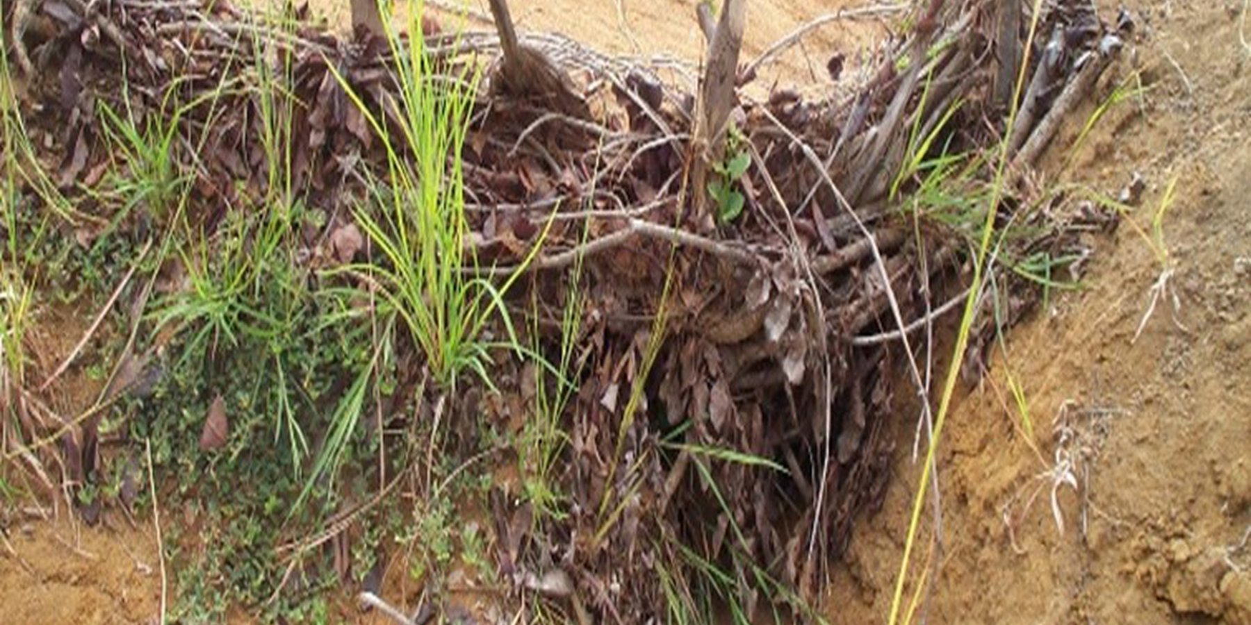
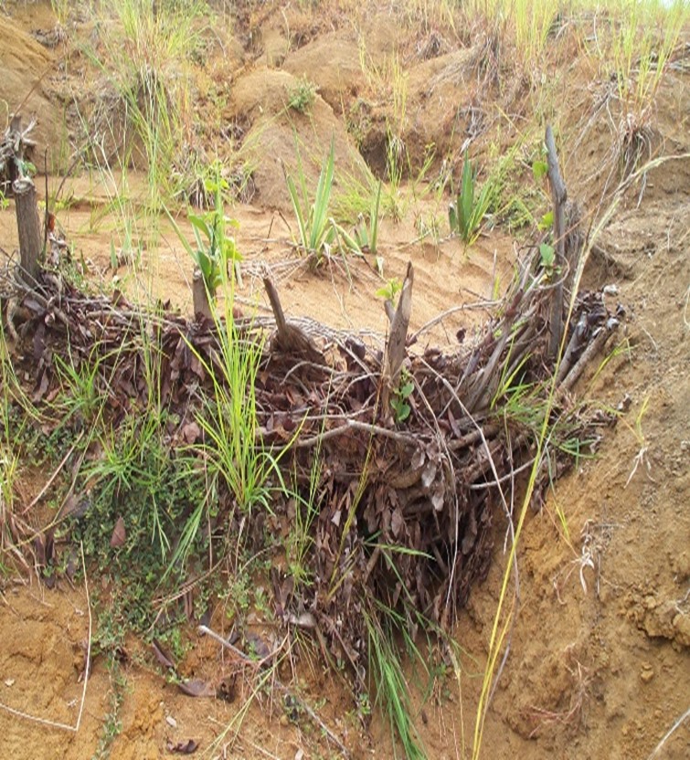
Fascines are check dams made of vegetative material installed in gullies to reduce erosion.
2.2 Detailed description of the Technology
Description:
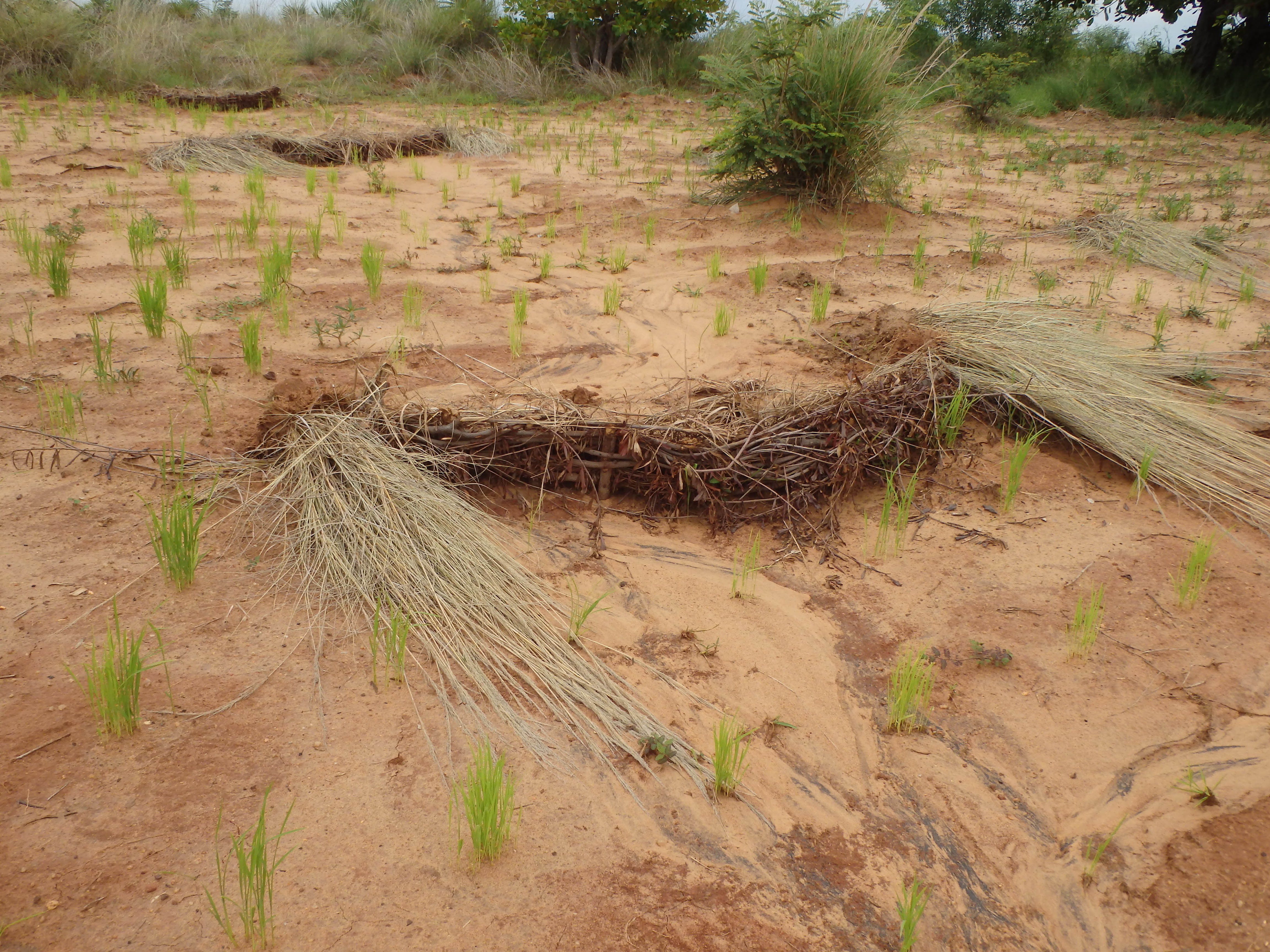
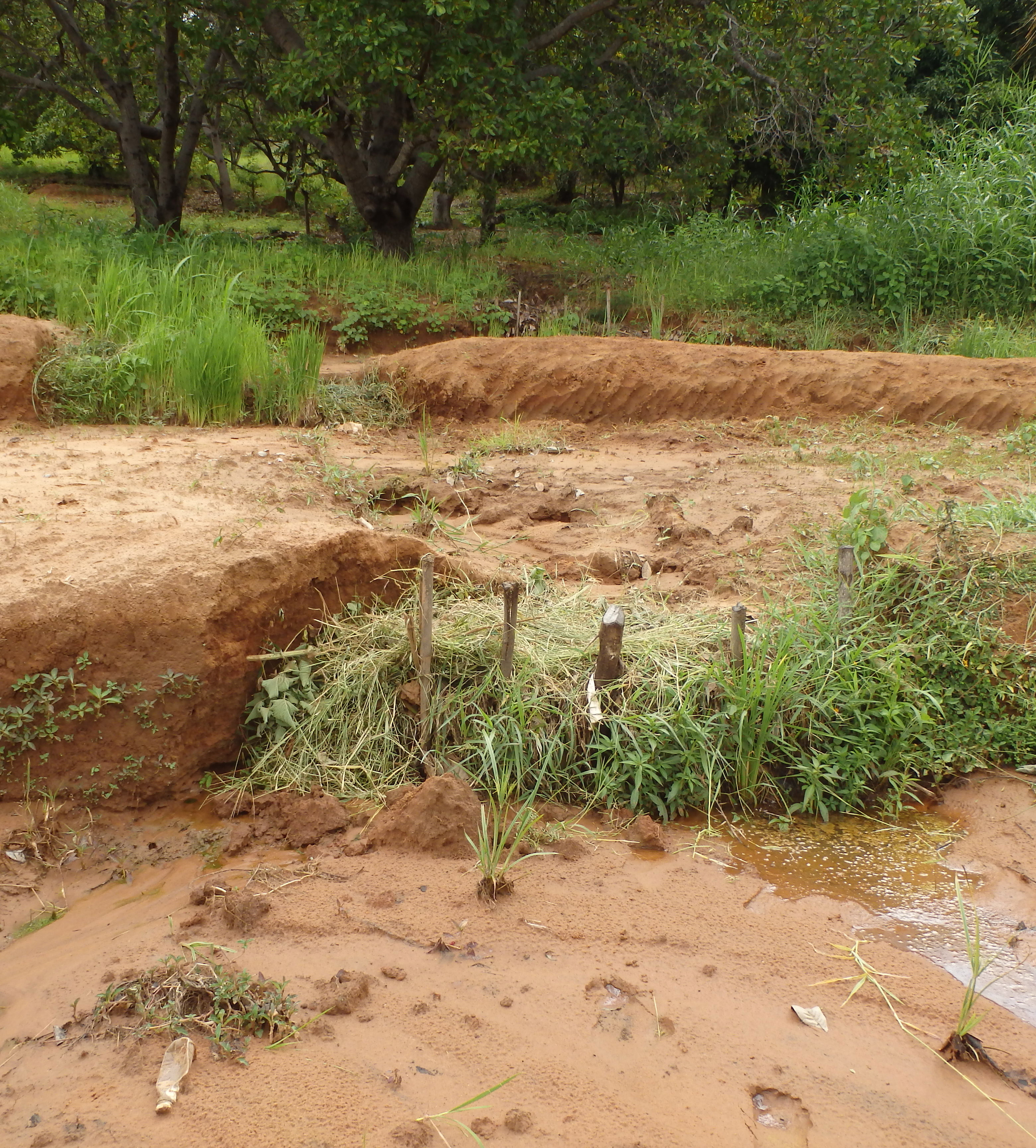
Fascines are check dams made of vegetative material used on sloping terrain (tanety) - often within cultivated fields - to control gully erosion. This technique is applicable in various types of farms.
Constructing fascines involves creating a row of wooden stakes, with 2/3 of their length buried in the ground and 1/3 above the surface. These stakes are placed side by side at a distance of 50 cm to 1 m. The stakes support interwoven branches, and plant debris (paipaika) is added to complete the structure, effectively blocking sediment carried by the runoff water.
To enhance stability and reduce maintenance, a row of Vetiver grass is planted downstream of the fascine, and stakes that can grow from cuttings (e.g., false Kapok, Jatropha) are utilized.
Fascines minimize soil loss and reduce deposits downstream plots. Their effectiveness can be assessed by observing the difference in the level behind and below the structures: a difference of half a metre or more indicates that the structure is effective.
The construction of fascines not only prevents further erosion and soil loss but also creates new cultivation areas upstream of the structures. Regular inspection and repairs are necessary after heavy rainfall.
The installation of fascines makes it possible to:
- control gullies;
- limit surface runoff and reduce erosion caused by runoff;
- improve water infiltration;
- protect downstream areas from silting.
Fascines can be used to help where contour grass strips have been damaged by rills and gullies. Farmers with erodible soils on slopes consider the installation of fascines essential to preserve the integrity of their plots. They have various ideas for improving them, for example by planting Vetiver grass, Brachiaria grass or sisal, or by using stakes which take root and grow.
2.3 Photos of the Technology
Media Gallery
2.5 Country/ region/ locations where the Technology has been applied and which are covered by this assessment
Country:
Madagascar
Region/ State/ Province:
Boeny
Further specification of location:
Ambalakida, Marovoay Banlieue, Tsaramandroso, Manerinerina
Specify the spread of the Technology:
- applied at specific points/ concentrated on a small area
Is/are the technology site(s) located in a permanently protected area?
No
Map
×2.6 Date of implementation
Indicate year of implementation:
2021
If precise year is not known, indicate approximate date:
- less than 10 years ago (recently)
2.7 Introduction of the Technology
Specify how the Technology was introduced:
- through projects/ external interventions
Comments (type of project, etc.):
GIZ ProSoil Madagascar
3. Classification of the SLM Technology
3.1 Main purpose(s) of the Technology
- improve production
- reduce, prevent, restore land degradation
- protect a watershed/ downstream areas – in combination with other Technologies
- reduce risk of disasters
3.2 Current land use type(s) where the Technology is applied
Land use mixed within the same land unit:
No

Cropland
- Annual cropping
- Perennial (non-woody) cropping
Annual cropping - Specify crops:
- cereals - maize
- legumes and pulses - beans
- legumes and pulses - peas
- oilseed crops - groundnuts
- root/tuber crops - cassava
- Cowpea, Mucuna
Perennial (non-woody) cropping - Specify crops:
- fodder crops - grasses
- Brachiaria, Vetiver
Number of growing seasons per year:
- 1
Is intercropping practiced?
Yes
If yes, specify which crops are intercropped:
Maize and peanuts
Maize and cowpeas
Is crop rotation practiced?
Yes
If yes, specify:
For Year N: combination of cereals and legumes or oilseeds. For Year N+1: maize. Year n+2: mucuna, and so on.
3.3 Has land use changed due to the implementation of the Technology?
Has land use changed due to the implementation of the Technology?
- No (Continue with question 3.4)
3.4 Water supply
Water supply for the land on which the Technology is applied:
- rainfed
3.5 SLM group to which the Technology belongs
- improved ground/ vegetation cover
- cross-slope measure
3.6 SLM measures comprising the Technology

vegetative measures
- V2: Grasses and perennial herbaceous plants

structural measures
- S2: Bunds, banks
- S11: Others
3.7 Main types of land degradation addressed by the Technology

soil erosion by water
- Wt: loss of topsoil/ surface erosion
- Wg: gully erosion/ gullying
3.8 Prevention, reduction, or restoration of land degradation
Specify the goal of the Technology with regard to land degradation:
- reduce land degradation
- restore/ rehabilitate severely degraded land
4. Technical specifications, implementation activities, inputs, and costs
4.1 Technical drawing of the Technology
Technical specifications (related to technical drawing):
Stakes should be driven 2/3 of the way into the ground and 1/3 above the surface. They are spaced 50 cm apart and intertwined with branches and plant debris. The height of the fascine should not exceed the depth of the gully.
Author:
GIZ ProSoil Madagascar, GSDM
Date:
05/19/2022
Technical specifications (related to technical drawing):
Where two fascines are installed in succession, the vertical interval between them should be 50 to 70 cm, depending on the inclination of the slope, and they should be installed from upstream to downstream.
Author:
GIZ ProSoil Madagascar, GSDM
Date:
05/19/2022
4.2 General information regarding the calculation of inputs and costs
Specify how costs and inputs were calculated:
- per Technology unit
Specify unit:
Fascine line
Specify dimensions of unit (if relevant):
3 to 4 m
other/ national currency (specify):
ariary
If relevant, indicate exchange rate from USD to local currency (e.g. 1 USD = 79.9 Brazilian Real): 1 USD =:
4300.0
Indicate average wage cost of hired labour per day:
5000
4.3 Establishment activities
| Activity | Timing (season) | |
|---|---|---|
| 1. | Collection of materials and construction | November-December |
| 2. | Planting of vetiver, brachiaria or sisal on fascines | December-January |
4.4 Costs and inputs needed for establishment
| Specify input | Unit | Quantity | Costs per Unit | Total costs per input | % of costs borne by land users | |
|---|---|---|---|---|---|---|
| Labour | Collection of materials and construction | man-days | 1.0 | 5000.0 | 5000.0 | 100.0 |
| Labour | Planting of vetiver, brachiaria or sisal on fascines | man-days | 1.0 | 5000.0 | 5000.0 | 100.0 |
| Plant material | Vetiver/brachiaria/sisal plants | Number | 10.0 | 100.0 | 1000.0 | |
| Total costs for establishment of the Technology | 11000.0 | |||||
| Total costs for establishment of the Technology in USD | 2.56 | |||||
If land user bore less than 100% of costs, indicate who covered the remaining costs:
man-days
Comments:
The costs mentioned are related to the installation of a fascine 5 m long and 25 cm high.
4.5 Maintenance/ recurrent activities
| Activity | Timing/ frequency | |
|---|---|---|
| 1. | Surveillance, repair or extension | Every week for 3 months and every major rainstorm (January to March) |
4.6 Costs and inputs needed for maintenance/ recurrent activities (per year)
| Specify input | Unit | Quantity | Costs per Unit | Total costs per input | % of costs borne by land users | |
|---|---|---|---|---|---|---|
| Labour | Surveillance and repair | man-days | 1.0 | 5000.0 | 5000.0 | 100.0 |
| Total costs for maintenance of the Technology | 5000.0 | |||||
| Total costs for maintenance of the Technology in USD | 1.16 | |||||
Comments:
Surveillance and maintenance are performed entirely by the farmers.
4.7 Most important factors affecting the costs
Describe the most determinate factors affecting the costs:
Labor for installation and maintenance
5. Natural and human environment
5.1 Climate
Annual rainfall
- < 250 mm
- 251-500 mm
- 501-750 mm
- 751-1,000 mm
- 1,001-1,500 mm
- 1,501-2,000 mm
- 2,001-3,000 mm
- 3,001-4,000 mm
- > 4,000 mm
Specify average annual rainfall (if known), in mm:
1400.00
Agro-climatic zone
- sub-humid
5.2 Topography
Slopes on average:
- flat (0-2%)
- gentle (3-5%)
- moderate (6-10%)
- rolling (11-15%)
- hilly (16-30%)
- steep (31-60%)
- very steep (>60%)
Landforms:
- plateau/plains
- ridges
- mountain slopes
- hill slopes
- footslopes
- valley floors
Altitudinal zone:
- 0-100 m a.s.l.
- 101-500 m a.s.l.
- 501-1,000 m a.s.l.
- 1,001-1,500 m a.s.l.
- 1,501-2,000 m a.s.l.
- 2,001-2,500 m a.s.l.
- 2,501-3,000 m a.s.l.
- 3,001-4,000 m a.s.l.
- > 4,000 m a.s.l.
Indicate if the Technology is specifically applied in:
- concave situations
5.3 Soils
Soil depth on average:
- very shallow (0-20 cm)
- shallow (21-50 cm)
- moderately deep (51-80 cm)
- deep (81-120 cm)
- very deep (> 120 cm)
Soil texture (topsoil):
- coarse/ light (sandy)
- medium (loamy, silty)
Soil texture (> 20 cm below surface):
- medium (loamy, silty)
- fine/ heavy (clay)
Topsoil organic matter:
- low (<1%)
5.4 Water availability and quality
Ground water table:
5-50 m
Availability of surface water:
medium
Water quality (untreated):
poor drinking water (treatment required)
Water quality refers to:
ground water
Is water salinity a problem?
No
Is flooding of the area occurring?
No
5.5 Biodiversity
Species diversity:
- high
Habitat diversity:
- low
Comments and further specifications on biodiversity:
The region boasts a wide array of plant and animal species, some of which are native to the region. Using fascines fosters the development of pedofauna, due to the accumulation of plant debris, which provides a food source for this fauna. In terms of habitats, approximately 20% of the region comprises suitable environments for supporting this biodiversity, including forests, water bodies, mangroves, and more, although this percentage remains relatively low.
5.6 Characteristics of land users applying the Technology
Sedentary or nomadic:
- Sedentary
Market orientation of production system:
- mixed (subsistence/ commercial)
Off-farm income:
- 10-50% of all income
Relative level of wealth:
- average
Individuals or groups:
- individual/ household
- groups/ community
Level of mechanization:
- manual work
- animal traction
Gender:
- women
- men
Age of land users:
- youth
- middle-aged
5.7 Average area of land used by land users applying the Technology
- < 0.5 ha
- 0.5-1 ha
- 1-2 ha
- 2-5 ha
- 5-15 ha
- 15-50 ha
- 50-100 ha
- 100-500 ha
- 500-1,000 ha
- 1,000-10,000 ha
- > 10,000 ha
Is this considered small-, medium- or large-scale (referring to local context)?
- medium-scale
5.8 Land ownership, land use rights, and water use rights
Land ownership:
- individual, not titled
- individual, titled
Land use rights:
- individual
Water use rights:
- open access (unorganized)
Are land use rights based on a traditional legal system?
Yes
Specify:
The lands are owned by those taking care of them.
5.9 Access to services and infrastructure
health:
- poor
- moderate
- good
education:
- poor
- moderate
- good
technical assistance:
- poor
- moderate
- good
employment (e.g. off-farm):
- poor
- moderate
- good
markets:
- poor
- moderate
- good
energy:
- poor
- moderate
- good
roads and transport:
- poor
- moderate
- good
drinking water and sanitation:
- poor
- moderate
- good
financial services:
- poor
- moderate
- good
6. Impacts and concluding statements
6.1 On-site impacts the Technology has shown
Socio-economic impacts
Production
crop production
Income and costs
expenses on agricultural inputs
farm income
workload
Socio-cultural impacts
food security/ self-sufficiency
Ecological impacts
Water cycle/ runoff
surface runoff
Soil
soil moisture
soil cover
soil loss
soil accumulation
Climate and disaster risk reduction
landslides/ debris flows
Specify assessment of on-site impacts (measurements):
These are estimates provided by the users interviewed.
6.2 Off-site impacts the Technology has shown
downstream siltation
Comments/ specify:
Siltation of downstream rice fields is reduced, which means the technology is advantageous.
damage on neighbours' fields
Specify assessment of off-site impacts (measurements):
These are estimates by the farmers.
6.3 Exposure and sensitivity of the Technology to gradual climate change and climate-related extremes/ disasters (as perceived by land users)
Climate-related extremes (disasters)
Meteorological disasters
| How does the Technology cope with it? | |
|---|---|
| tropical storm | not well |
| local rainstorm | well |
| local thunderstorm | well |
| local hailstorm | moderately |
6.4 Cost-benefit analysis
How do the benefits compare with the establishment costs (from land users’ perspective)?
Short-term returns:
slightly positive
Long-term returns:
positive
How do the benefits compare with the maintenance/ recurrent costs (from land users' perspective)?
Short-term returns:
slightly positive
Long-term returns:
positive
6.5 Adoption of the Technology
- single cases/ experimental
6.6 Adaptation
Has the Technology been modified recently to adapt to changing conditions?
No
6.7 Strengths/ advantages/ opportunities of the Technology
| Strengths/ advantages/ opportunities in the land user’s view |
|---|
| Surface water erosion is halted and water-borne sediment accumulates behind the fascines. |
| The silting or sanding of downstream rice fields is reduced, thus increasing production in these fields. |
| The soil accumulated behind the fascines can be cultivated, increasing agricultural production. |
6.8 Weaknesses/ disadvantages/ risks of the Technology and ways of overcoming them
| Weaknesses/ disadvantages/ risks in the land user’s view | How can they be overcome? |
|---|---|
| Cyclones cause too much rain and water erosion, which means that installations are sometimes washed away. | Rebuild the fascines. |
| The system is fairly costly and labor-intensive to set up. | Hire labor for the work, but prioritize activities based on available resources. |
| Fascines do not totally stop water erosion, since water always finds another way through. | Extend the area covered by fascines and build new ones depending on erosion. |
| Weaknesses/ disadvantages/ risks in the compiler’s or other key resource person’s view | How can they be overcome? |
|---|---|
| Facines are rehabilitation techniques that must be systematically coupled with other preventive protective measures. | Use of standard or enriched grass strips. |
7. References and links
7.1 Methods/ sources of information
- field visits, field surveys
Five (5) fields visited
- interviews with land users
Five (5) farmers interviewed
- compilation from reports and other existing documentation
GIZ ProSoil Madagascar technical sheet
When were the data compiled (in the field)?
01/31/2023
7.2 References to available publications
Title, author, year, ISBN:
Région Boeny, 2016, "Schéma Régional d’Aménagement du Territoire de la Région Boeny"
Available from where? Costs?
Boeny Region Hotel
Title, author, year, ISBN:
GIZ ProSol Madagascar, 2022, "Livret des Paysans Relais"
Available from where? Costs?
GIZ ProSol Madagascar
Title, author, year, ISBN:
GIZ ProSol Madagascar, 2022, Poster "Fascines et cordon de paille"
Available from where? Costs?
GIZ ProSol Madagascar
Title, author, year, ISBN:
Raharinaivo S., 2008, "Les techniques de correction des ravines et de stabilisations des Lavaka" tirés des acquis du PLAE Marovoay
Available from where? Costs?
https://wocatpedia.net/images/d/d9/Solofo_Raharinaivo_%282008%29_-_Les_techniques_de_Correction_des_ravines_et_de_Stabilisation_des_Lavaka_.pdf
7.3 Links to relevant online information
Title/ description:
Les Fascines (Fiche technique, Hydraulique douce)
URL:
https://marne.chambre-agriculture.fr/fileadmin/user_upload/National/FAL_commun/publications/Grand-Est/51-Fiche-hydraulique-douce-fascine.pdf
Links and modules
Expand all Collapse allLinks
No links
Modules
No modules