Contour Farming [Madagascar]
- Creation:
- Update:
- Compiler: Harifidy RAKOTO RATSIMBA
- Editors: Felana Nantenaina RAMALASON, Dimby RAHERINJATOVOARISON, Siagbé Golli, Tahiry Ravivonandrasana, Natacha Rabeary, Tabitha Nekesa, Ahmadou Gaye
- Reviewers: William Critchley, Rima Mekdaschi Studer
Fiasana tany mifanohitra amin'ny fisolampy ny tany
technologies_6479 - Madagascar
View sections
Expand all Collapse all1. General information
1.2 Contact details of resource persons and institutions involved in the assessment and documentation of the Technology
Key resource person(s)
land user:
ANDRIANALISON Dod
Madagascar
land user:
RATOVONIRINA Alison Johnny
Madagascar
land user:
RABEMANANJARA Daniel
Madagascar
land user:
ANDRIATIANA Guillaume Sylver
Madagascar
land user:
RANDRIANANDRASANA Tsimihery Jean
Madagascar
Name of project which facilitated the documentation/ evaluation of the Technology (if relevant)
Soil protection and rehabilitation for food security (ProSo(i)l)Name of the institution(s) which facilitated the documentation/ evaluation of the Technology (if relevant)
Deutsche Gesellschaft für Internationale Zusammenarbeit (GIZ)1.3 Conditions regarding the use of data documented through WOCAT
The compiler and key resource person(s) accept the conditions regarding the use of data documented through WOCAT:
Yes
1.4 Declaration on sustainability of the described Technology
Is the Technology described here problematic with regard to land degradation, so that it cannot be declared a sustainable land management technology?
No
2. Description of the SLM Technology
2.1 Short description of the Technology
Definition of the Technology:
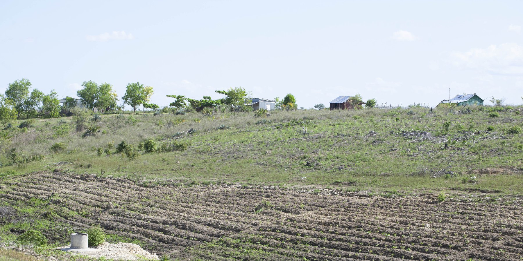
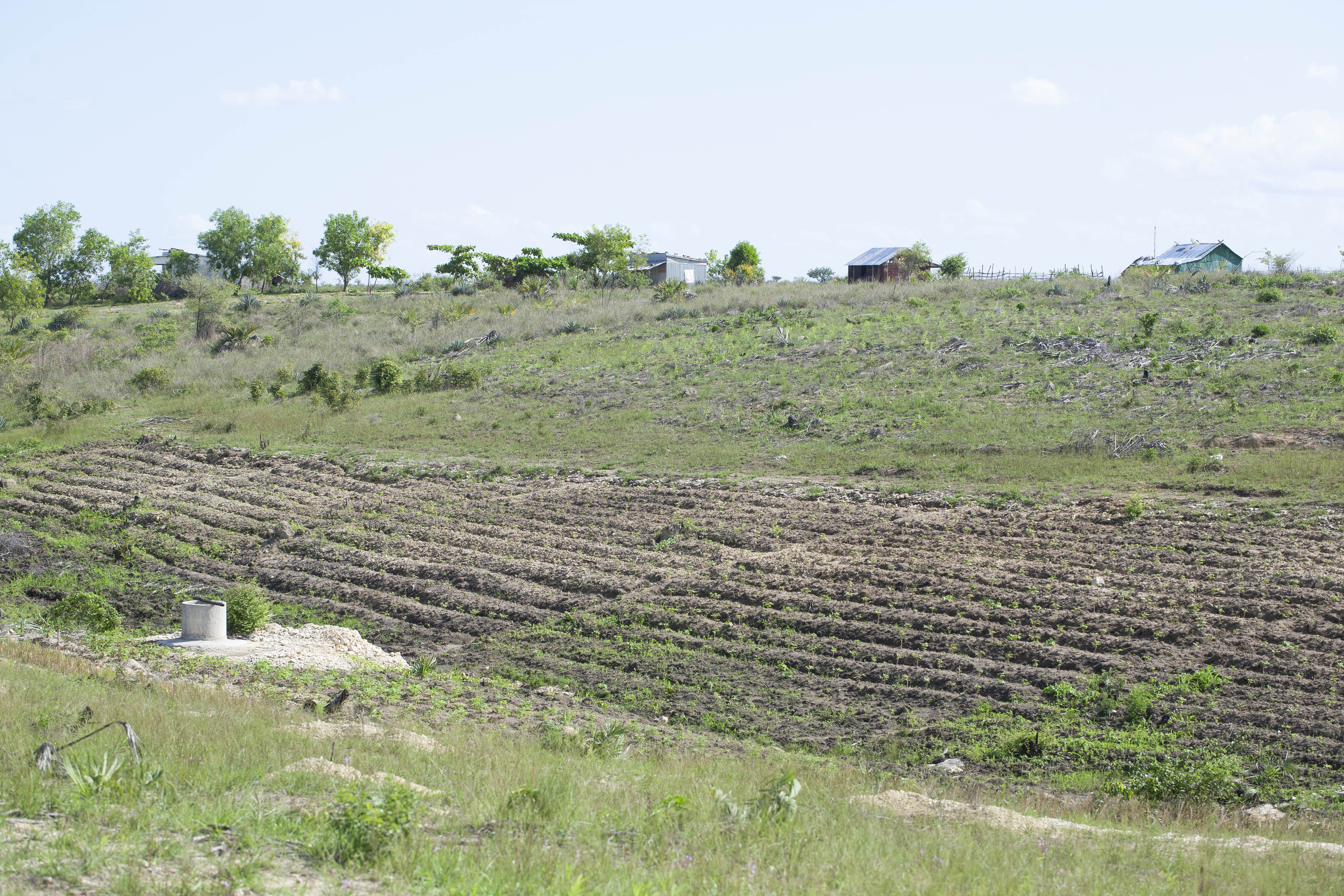
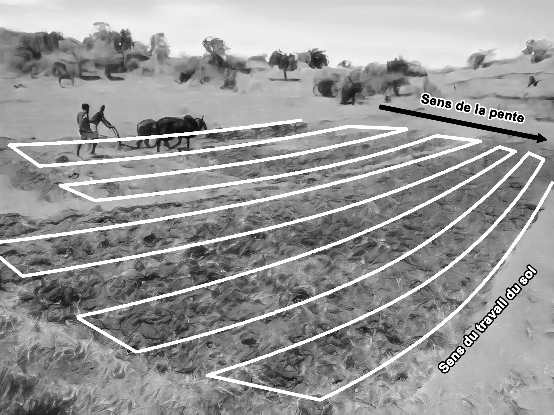
Contour farming involves cultivating the soil perpendicular to the slope, that is ploughing along the contour. This minimizes runoff-induced erosion.
2.2 Detailed description of the Technology
Description:
Contour farming involves cultivating the soil perpendicular to the slope: that is ploughing along the contour. Contour farming is suitable for gently sloping terrain (< 5%). On land with steeper slopes (≥10%), it is necessary to combine tillage with other erosion control measures, such as the use of grass strips. However, cultivating on very steep slopes is not advisable due to their high exposure to erosion.
This technology enhances water availability for plants in the soil, reducing surface runoff and slowing down the velocity of water during runoff. Nevertheless, working the soil perpendicular to the slope can pose challenges on narrow plots:
- more passes are needed, which takes more time;
- the slope sometimes makes it difficult to maintain plough stability;
- in the case of single-share ploughs, if the slope is steep, the direction of passage is particularly difficult.
The ideal way to work the soil is to follow contour lines, but this recommendation is sometimes difficult or even impossible to apply when the terrain is uneven. Contour surveying can also be too demanding for some farmers. In such cases, identifying the general cross-slope direction becomes a practical recommendation, even if it does not strictly adhere to contour lines.
This type of tillage not only protects downstream plots from sand and sediment influx, but also prevents the loss of useful soil onsite, thereby improving water infiltration. It also facilitates the conservation of organic matter from crop residues and encourages biological life in the soil.
2.3 Photos of the Technology
Media Gallery
2.5 Country/ region/ locations where the Technology has been applied and which are covered by this assessment
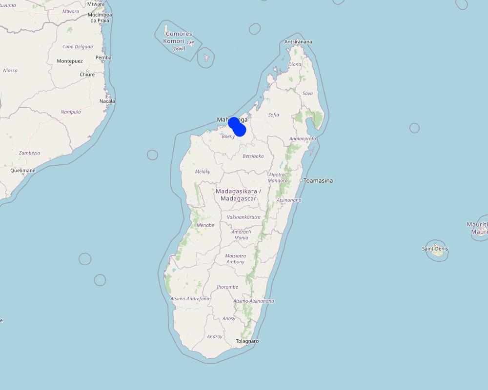
Country:
Madagascar
Region/ State/ Province:
Boeny
Further specification of location:
Belobaka, Antanambao Andranolava, Marovoay Banlieue
Specify the spread of the Technology:
- evenly spread over an area
If precise area is not known, indicate approximate area covered:
- < 0.1 km2 (10 ha)
Is/are the technology site(s) located in a permanently protected area?
No
Map
×2.6 Date of implementation
Indicate year of implementation:
2021
If precise year is not known, indicate approximate date:
- less than 10 years ago (recently)
2.7 Introduction of the Technology
Specify how the Technology was introduced:
- as part of a traditional system (> 50 years)
- through projects/ external interventions
Comments (type of project, etc.):
GIZ ProSol Madagascar
3. Classification of the SLM Technology
3.1 Main purpose(s) of the Technology
- improve production
- reduce, prevent, restore land degradation
- protect a watershed/ downstream areas – in combination with other Technologies
- create beneficial economic impact
3.2 Current land use type(s) where the Technology is applied
Land use mixed within the same land unit:
Yes
Specify mixed land use (crops/ grazing/ trees):
- Agroforestry

Cropland
- Annual cropping
Annual cropping - Specify crops:
- cereals - maize
- cereals - rice (upland)
- cereals - sorghum
- legumes and pulses - beans
- legumes and pulses - peas
- legumes and pulses - soya
- root/tuber crops - cassava
- Cowpeas
Number of growing seasons per year:
- 1
Is intercropping practiced?
Yes
If yes, specify which crops are intercropped:
Maize and mung beans
Maize and cowpeas
Is crop rotation practiced?
Yes
If yes, specify:
For Year N, a combination of cereal and legume crops. For year N+1, rice. For year N+2, cassava, and so on.
3.3 Has land use changed due to the implementation of the Technology?
Has land use changed due to the implementation of the Technology?
- No (Continue with question 3.4)
3.4 Water supply
Water supply for the land on which the Technology is applied:
- rainfed
3.5 SLM group to which the Technology belongs
- improved ground/ vegetation cover
- cross-slope measure
3.6 SLM measures comprising the Technology

agronomic measures
- A1: Vegetation/ soil cover
- A3: Soil surface treatment
A3: Differentiate tillage systems:
A 3.3: Full tillage (< 30% soil cover)

structural measures
3.7 Main types of land degradation addressed by the Technology

soil erosion by water
- Wt: loss of topsoil/ surface erosion
3.8 Prevention, reduction, or restoration of land degradation
Specify the goal of the Technology with regard to land degradation:
- reduce land degradation
4. Technical specifications, implementation activities, inputs, and costs
4.1 Technical drawing of the Technology
Technical specifications (related to technical drawing):
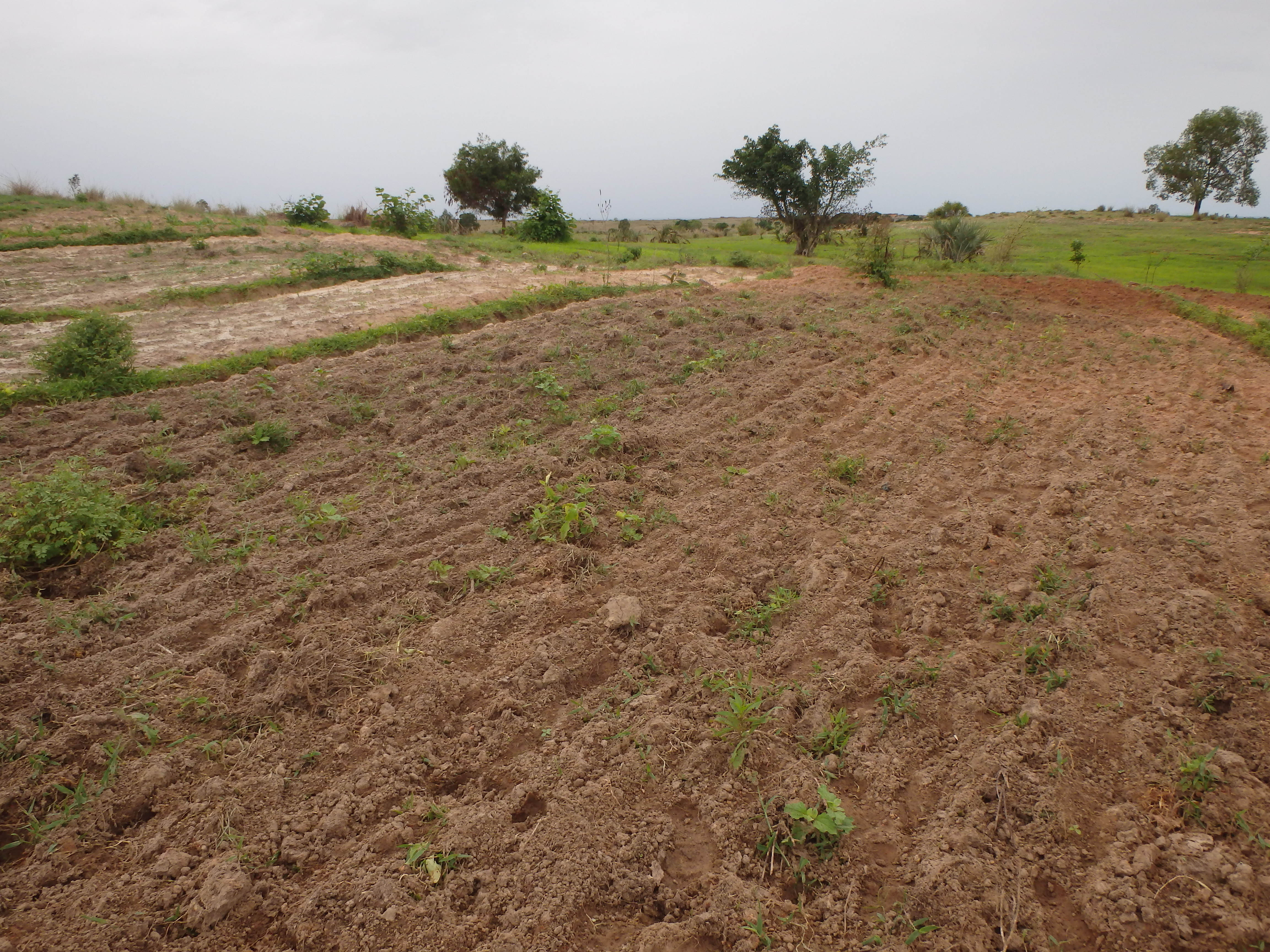
The soil is ploughed at right angles to the direction of the slope. Farmers leave no space between each furrow, but plough the entire plot.
In some cases, farmers may stake out contour lines before tilling, and the furrows must be traced along these lines.
Author:
GIZ ProSoil Madagascar
Date:
01/02/2023
4.2 General information regarding the calculation of inputs and costs
Specify how costs and inputs were calculated:
- per Technology area
Indicate size and area unit:
1 hectare
other/ national currency (specify):
ariary
If relevant, indicate exchange rate from USD to local currency (e.g. 1 USD = 79.9 Brazilian Real): 1 USD =:
4300.0
Indicate average wage cost of hired labour per day:
7500
4.3 Establishment activities
| Activity | Timing (season) | |
|---|---|---|
| 1. | Soil cultivation along contour lines (plow + harrow) | November-December |
4.4 Costs and inputs needed for establishment
| Specify input | Unit | Quantity | Costs per Unit | Total costs per input | % of costs borne by land users | |
|---|---|---|---|---|---|---|
| Equipment | Soil cultivation along contour lines (plow + harrow) | animal traction | 5.0 | 12000.0 | 60000.0 | 100.0 |
| Equipment | Spade | Number | 5.0 | 12000.0 | 60000.0 | 100.0 |
| Equipment | Shovel | Number | 1.0 | 250000.0 | 250000.0 | 100.0 |
| Equipment | Plow | Number | ||||
| Total costs for establishment of the Technology | 370000.0 | |||||
| Total costs for establishment of the Technology in USD | 86.05 | |||||
Comments:
Farmers are solely responsible for acquiring the equipment, though it is generally assumed that they already possess it. The project focuses on providing training for the application of the technique.
4.5 Maintenance/ recurrent activities
| Activity | Timing/ frequency | |
|---|---|---|
| 1. | Soil cultivation along contour line (plow + harrow) | November-December |
4.6 Costs and inputs needed for maintenance/ recurrent activities (per year)
| Specify input | Unit | Quantity | Costs per Unit | Total costs per input | % of costs borne by land users | |
|---|---|---|---|---|---|---|
| Equipment | Soil cultivation along contour lines (plow+harrow) | animal traction | 10.0 | 20000.0 | 200000.0 | 100.0 |
| Total costs for maintenance of the Technology | 200000.0 | |||||
| Total costs for maintenance of the Technology in USD | 46.51 | |||||
4.7 Most important factors affecting the costs
Describe the most determinate factors affecting the costs:
Equipment and labor for the implementation of the technology
5. Natural and human environment
5.1 Climate
Annual rainfall
- < 250 mm
- 251-500 mm
- 501-750 mm
- 751-1,000 mm
- 1,001-1,500 mm
- 1,501-2,000 mm
- 2,001-3,000 mm
- 3,001-4,000 mm
- > 4,000 mm
Specify average annual rainfall (if known), in mm:
1400.00
Agro-climatic zone
- sub-humid
5.2 Topography
Slopes on average:
- flat (0-2%)
- gentle (3-5%)
- moderate (6-10%)
- rolling (11-15%)
- hilly (16-30%)
- steep (31-60%)
- very steep (>60%)
Landforms:
- plateau/plains
- ridges
- mountain slopes
- hill slopes
- footslopes
- valley floors
Altitudinal zone:
- 0-100 m a.s.l.
- 101-500 m a.s.l.
- 501-1,000 m a.s.l.
- 1,001-1,500 m a.s.l.
- 1,501-2,000 m a.s.l.
- 2,001-2,500 m a.s.l.
- 2,501-3,000 m a.s.l.
- 3,001-4,000 m a.s.l.
- > 4,000 m a.s.l.
Indicate if the Technology is specifically applied in:
- not relevant
5.3 Soils
Soil depth on average:
- very shallow (0-20 cm)
- shallow (21-50 cm)
- moderately deep (51-80 cm)
- deep (81-120 cm)
- very deep (> 120 cm)
Soil texture (topsoil):
- coarse/ light (sandy)
- medium (loamy, silty)
Soil texture (> 20 cm below surface):
- fine/ heavy (clay)
Topsoil organic matter:
- high (>3%)
- medium (1-3%)
5.4 Water availability and quality
Ground water table:
5-50 m
Availability of surface water:
good
Water quality (untreated):
poor drinking water (treatment required)
Water quality refers to:
ground water
Is water salinity a problem?
No
Is flooding of the area occurring?
No
5.5 Biodiversity
Species diversity:
- medium
Habitat diversity:
- low
Comments and further specifications on biodiversity:
This region boasts a diverse array of plant and animal species, with some being native. However, this quantity remains low compared to other regions of the island. In terms of habitats, approximately 20% of the area can serve as a habitat for this biodiversity (forests, bodies of water, mangroves, etc.), which remains fairly low.
5.6 Characteristics of land users applying the Technology
Sedentary or nomadic:
- Sedentary
Market orientation of production system:
- subsistence (self-supply)
- mixed (subsistence/ commercial)
Off-farm income:
- less than 10% of all income
Relative level of wealth:
- poor
- average
Individuals or groups:
- individual/ household
- groups/ community
Level of mechanization:
- manual work
- animal traction
Gender:
- women
- men
Age of land users:
- youth
- middle-aged
5.7 Average area of land used by land users applying the Technology
- < 0.5 ha
- 0.5-1 ha
- 1-2 ha
- 2-5 ha
- 5-15 ha
- 15-50 ha
- 50-100 ha
- 100-500 ha
- 500-1,000 ha
- 1,000-10,000 ha
- > 10,000 ha
Is this considered small-, medium- or large-scale (referring to local context)?
- small-scale
- medium-scale
5.8 Land ownership, land use rights, and water use rights
Land ownership:
- individual, not titled
- individual, titled
Land use rights:
- leased
- individual
Water use rights:
- open access (unorganized)
Are land use rights based on a traditional legal system?
No
5.9 Access to services and infrastructure
health:
- poor
- moderate
- good
education:
- poor
- moderate
- good
technical assistance:
- poor
- moderate
- good
employment (e.g. off-farm):
- poor
- moderate
- good
markets:
- poor
- moderate
- good
energy:
- poor
- moderate
- good
roads and transport:
- poor
- moderate
- good
drinking water and sanitation:
- poor
- moderate
- good
financial services:
- poor
- moderate
- good
6. Impacts and concluding statements
6.1 On-site impacts the Technology has shown
Socio-economic impacts
Production
crop production
crop quality
Income and costs
workload
Ecological impacts
Water cycle/ runoff
surface runoff
Soil
soil moisture
soil loss
Specify assessment of on-site impacts (measurements):
These are estimates provided by the farmers interviewed.
6.2 Off-site impacts the Technology has shown
downstream siltation
Comments/ specify:
Positive
damage on neighbours' fields
Specify assessment of off-site impacts (measurements):
These are estimates provided by the farmers interviewed.
6.3 Exposure and sensitivity of the Technology to gradual climate change and climate-related extremes/ disasters (as perceived by land users)
Climate-related extremes (disasters)
Meteorological disasters
| How does the Technology cope with it? | |
|---|---|
| tropical storm | moderately |
| local rainstorm | moderately |
6.4 Cost-benefit analysis
How do the benefits compare with the establishment costs (from land users’ perspective)?
Short-term returns:
slightly negative
Long-term returns:
positive
How do the benefits compare with the maintenance/ recurrent costs (from land users' perspective)?
Short-term returns:
positive
Long-term returns:
very positive
6.5 Adoption of the Technology
- 1-10%
Of all those who have adopted the Technology, how many did so spontaneously, i.e. without receiving any material incentives/ payments?
- 91-100%
6.6 Adaptation
Has the Technology been modified recently to adapt to changing conditions?
No
6.7 Strengths/ advantages/ opportunities of the Technology
| Strengths/ advantages/ opportunities in the land user’s view |
|---|
| Increased agricultural production due to reduced surface water erosion. Therefore, the soil retains more water and topsoil used by crops. |
6.8 Weaknesses/ disadvantages/ risks of the Technology and ways of overcoming them
| Weaknesses/ disadvantages/ risks in the land user’s view | How can they be overcome? |
|---|---|
| Contour farming is difficult if the plots are too narrow. | Utilization of reversible plows. |
7. References and links
7.1 Methods/ sources of information
- field visits, field surveys
Five (5) fields visited
- interviews with land users
Five (5) farmers interviewed
- compilation from reports and other existing documentation
GIZ ProSoil Madagascar technical sheet
When were the data compiled (in the field)?
01/31/2023
7.2 References to available publications
Title, author, year, ISBN:
Région Boeny, 2016, "Schéma Régional d’Aménagement du Territoire de la Région Boeny"
Available from where? Costs?
Boeny Region Hotel
7.3 Links to relevant online information
Title/ description:
Jacques Beauchamp, "LA LUTTE CONTRE L’EROSION DES SOLS DANS LES REGIONS DE GRANDES CULTURES"
URL:
https://www.u-picardie.fr/beauchamp/mst/Erosion_sol/Erosion-sol.htm
Title/ description:
"Taille, forme et orientation des parcelles"/"Plot size, shape and orientation"
URL:
https://agripedia.ch/erosion/taille-forme-et-orientation-des-parcelles/
Title/ description:
"Le travail du sol perpendiculaire à la pente"/"Slope-perpendicular plowing"
URL:
https://soatany.org/fiches-techniques/
Links and modules
Expand all Collapse allLinks
No links
Modules
No modules