
Double Basin Masonry Check Dam [Ethiopia]
- Creation:
- Update:
- Compiler: GERBA LETA
- Editors: Torben Helbig, Noel Templer, Tabitha Nekesa, Ahmadou Gaye, Siagbé Golli
- Reviewers: William Critchley, Rima Mekdaschi Studer, Sally Bunning
NA
technologies_6716 - Ethiopia
View sections
Expand all Collapse all1. General information
1.2 Contact details of resource persons and institutions involved in the assessment and documentation of the Technology
Key resource person(s)
SLM specialist:
Abdi Amir
Dry valley Rehabilitation and Productive Use (DVRPU) project of the GIZ
Ethiopia
Name of project which facilitated the documentation/ evaluation of the Technology (if relevant)
Soil protection and rehabilitation for food security (ProSo(i)l)Name of the institution(s) which facilitated the documentation/ evaluation of the Technology (if relevant)
CIAT International Center for Tropical Agriculture (CIAT International Center for Tropical Agriculture) - Kenya1.3 Conditions regarding the use of data documented through WOCAT
The compiler and key resource person(s) accept the conditions regarding the use of data documented through WOCAT:
Yes
1.4 Declaration on sustainability of the described Technology
Is the Technology described here problematic with regard to land degradation, so that it cannot be declared a sustainable land management technology?
No
Comments:
The Check Dam helps to arrest the runoff of flood and rehabilitate the gully development.
1.5 Reference to Questionnaire(s) on SLM Approaches (documented using WOCAT)
Participatory Rehabilitation of Dry Valleys [Ethiopia]
Participatory rehabilitation and productive use of dry valleys is an approach employed to rehabilitate degraded and degradable land. It is operationalised through the Lowland Soil Rehabilitation Project with local development partners from kebele, district, regional agricultural bureaus, and other relevant stakeholders.
- Compiler: GERBA LETA
2. Description of the SLM Technology
2.1 Short description of the Technology
Definition of the Technology:
A double basin masonry check dam is a physical structure that helps to stop gully formation or further development of gullies in dry valleys. It rehabilitates small to a medium-sized deep gullies that are eating into the heart of adjacent land.
2.2 Detailed description of the Technology
Description:
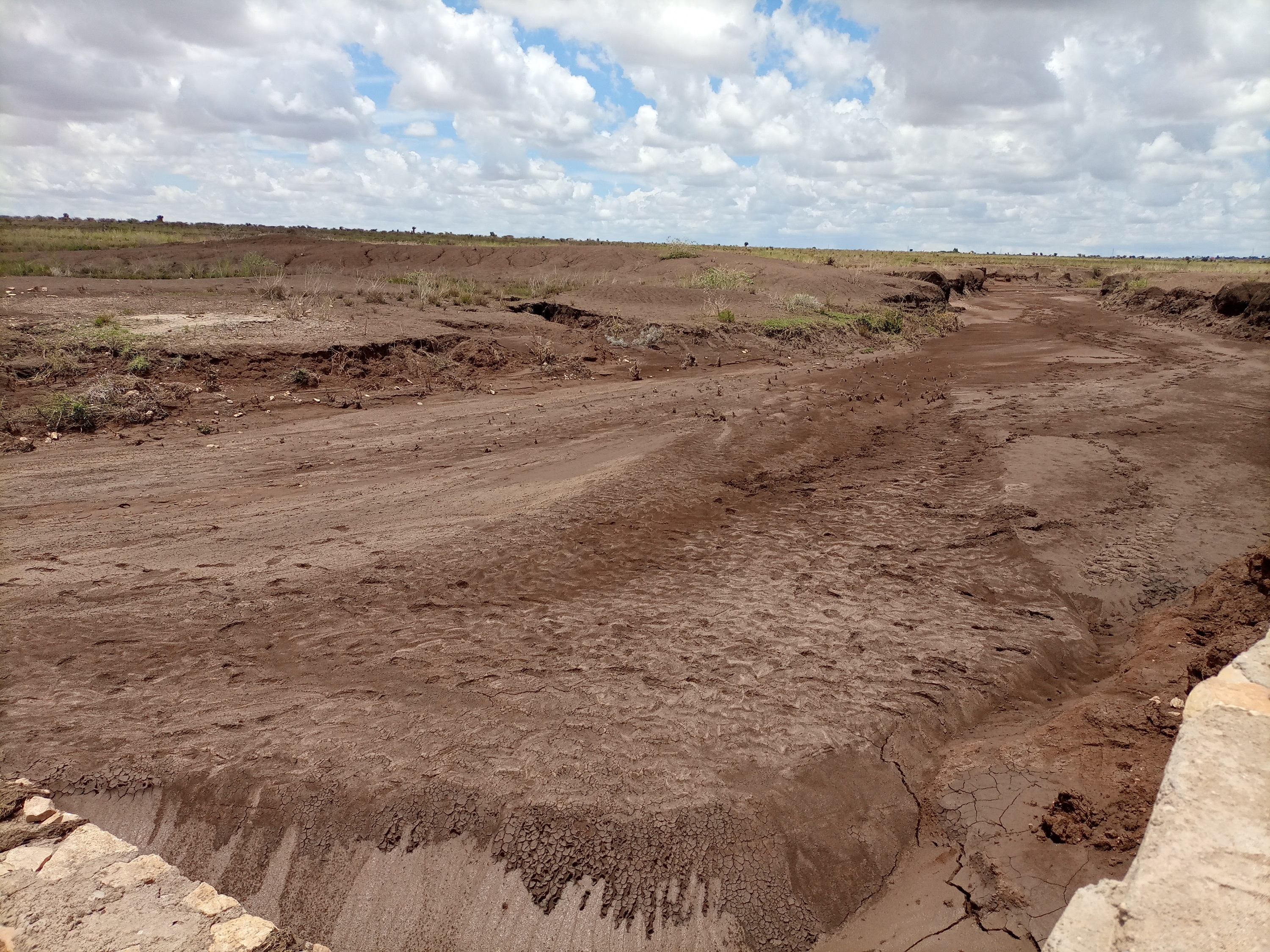
A “double basin masonry check dam” is a structure built in a narrow gully or depression to stop further gully formation. It is made of stone, concrete, gabions and wooden bars and serves as a permanent barrier. In this particular site stone is used as the structure is masonry. The technology is applied in areas where there are concentrated flows of water or runoff. The double basin masonry check dam is sited across a slope or a deep gully to slow water flow and capture sediment from upstream in the basins and behind the structure, thereby preventing expansion of the gully. The width of a check dam is variable. This particular structure is 14 meter wide, three meters deep and about 52 meters long. By helping to fill up the gully with sediment, it leads to rehabilitation and makes productive use of the area for growing trees, forage, and other plants. Apart from reducing the speed of surface runoff, the structure also promotes water infiltration, and recharges the groundwater reserves in the aquifer.
The main inputs necessary to build the check dams are financial resources, technical skills, skilled and unskilled labour, and construction materials including sand, stone, cement, water and other materials. Furthermore, construction tools such as a theodolite, line level, string, hammers, spades, hoes, and other tools are essential for design & construction. Technical skills for designing and profiling, and further capacity-building training are essential also. Application of the technology is also supported by satellite image and ground truthing to ensure the precision of siting.
The agropastoralists in the dry basin areas are pleased to see a huge movement of the soil arrested by the structure. The reduced expansion of the gully into the heart of the farm and grazing lands raises hopes of their land become productive and remaining so for generations to come. This hope and expectation have motivated them to welcome the intervention and develop an understanding of the actual benefits accrued from it. This leads to their support for the construction efforts. The disadvantages are that the technology is labour and resource-intensive which can be unaffordable for resource-poor agropastoralist communities living in food-insecure areas where rainfall is unreliable. This may make the adoption of the technology difficult to establish and nurture on their own without outside support.
2.3 Photos of the Technology
Media Gallery
General remarks regarding photos:
The photos display a large amount of sediment captured by a few days' shower post recurrent droughts experienced in the area over the last two to three years.
2.4 Videos of the Technology
Comments, short description:
Video of the technology was not taken by this particular documentation exercise.
2.5 Country/ region/ locations where the Technology has been applied and which are covered by this assessment
Country:
Ethiopia
Region/ State/ Province:
Somali
Further specification of location:
Hadow kebele of south Jigjiga district
Specify the spread of the Technology:
- applied at specific points/ concentrated on a small area
Is/are the technology site(s) located in a permanently protected area?
No
Comments:
Locating the check dam closer to each other may help to stop the damage of heavy and concentrated flood moving in the drainage basin.

Map
×2.6 Date of implementation
Indicate year of implementation:
2021
2.7 Introduction of the Technology
Specify how the Technology was introduced:
- through projects/ external interventions
Comments (type of project, etc.):
Capacity Development and Strengthening Drought Resilience (CDSDR) project of the GIZ in Somali Region.
3. Classification of the SLM Technology
3.1 Main purpose(s) of the Technology
- reduce, prevent, restore land degradation
- conserve ecosystem
- protect a watershed/ downstream areas – in combination with other Technologies
- preserve/ improve biodiversity
- reduce risk of disasters
3.2 Current land use type(s) where the Technology is applied
Land use mixed within the same land unit:
No
3.3 Has land use changed due to the implementation of the Technology?
Has land use changed due to the implementation of the Technology?
- No (Continue with question 3.4)
3.4 Water supply
Water supply for the land on which the Technology is applied:
- rainfed
Comments:
Rainfed is the type of water supply that often experiences erratic distribution characterized by the reception of lower amounts. Mostly characterized by erratic and erosive feature.
3.5 SLM group to which the Technology belongs
- pastoralism and grazing land management
- cross-slope measure
- water harvesting
3.6 SLM measures comprising the Technology

structural measures
- S6: Walls, barriers, palisades, fences
3.7 Main types of land degradation addressed by the Technology

soil erosion by water
- Wt: loss of topsoil/ surface erosion
- Wg: gully erosion/ gullying
- Wm: mass movements/ landslides
3.8 Prevention, reduction, or restoration of land degradation
Specify the goal of the Technology with regard to land degradation:
- reduce land degradation
- restore/ rehabilitate severely degraded land
Comments:
The technology stops the mass movement of soil and water. As a result, it reduces land degradation, rehabilitates the degraded dry valley, and makes the land available for productive uses.
4. Technical specifications, implementation activities, inputs, and costs
4.1 Technical drawing of the Technology

Technical specifications (related to technical drawing):
The design (layout - top view) and profile (lower view) of the technology is presented with universal units to clearly read and understand by the SLM experts or engineers. In addition, there are section drawings of the main weir and Bill of Quantity (BOQ).
Author:
Amir Abdi
Date:
14/12/2018
4.2 General information regarding the calculation of inputs and costs
Specify how costs and inputs were calculated:
- per Technology unit
Specify unit:
check dam
Specify dimensions of unit (if relevant):
14m*3m*52m =2184m3
Specify currency used for cost calculations:
- USD
Indicate average wage cost of hired labour per day:
8.5 - 16 USD based on their skills
4.3 Establishment activities
| Activity | Timing (season) | |
|---|---|---|
| 1. | Conduct rapid assessment and Surveillance of intervention site | During the off-season |
| 2. | Finalize site selection | ditto |
| 3. | Layout, Design and profiling works | |
| 4. | Identify and train masonry workers | During off-season |
| 5. | Material supply | |
| 6. | Start actual layout and excavation work | |
| 7. | Supervision... |
Comments:
Once intended to put the technology or the structure in place, a series of activities are conducted involving experts and contract workers until the activities are effectively finalized.
4.4 Costs and inputs needed for establishment
If you are unable to break down the costs in the table above, give an estimation of the total costs of establishing the Technology:
9200.0
If land user bore less than 100% of costs, indicate who covered the remaining costs:
The project is responsible to cover the cost.
Comments:
The cost for an unskilled casual laborer a day is 8.5 USD whereas the daily cost of a skilled Masonry worker is 16 USD per day.
4.5 Maintenance/ recurrent activities
| Activity | Timing/ frequency | |
|---|---|---|
| 1. | Oversee and identify damage | During and after rainy season |
| 2. | Measure the degrees of damage | ditto |
| 3. | Quantify cost and materials needed | |
| 4. | Schedule the maintenance work | Right before the off-season |
| 5. | Employ the workers and reconstruct the damaged parts or upgrade it. | During off-season |
Comments:
As some of the technology implementation sites are inaccessible during the rainy season, implementing the activities during the off-season is commendable.
4.6 Costs and inputs needed for maintenance/ recurrent activities (per year)
If you are unable to break down the costs in the table above, give an estimation of the total costs of maintaining the Technology:
3244.0
If land user bore less than 100% of costs, indicate who covered the remaining costs:
The project is expected to cover the entire maintenance cost. However, maintenance cost is attributed to various factors including the degree of damage, material costs at the time, etc. The figure merely represents an estimation of the cost, on average.
Comments:
As the dry land receive erratic and erosive rain, damage to the structure is not uncommon. Combining fast-growing trees and deep-rooted perennial fodder grass stabilizes the sediment and reduces the speed of run-off on top of the structure. Therefore, associating the structure with biological barriers right after the first season of rain is a mandatory action that assists to reduce the damage and maintenance cost that is not affordable by resource-poor communities.
4.7 Most important factors affecting the costs
Describe the most determinate factors affecting the costs:
Inflation and increasingly changing material prices, labor and transportation costs.
5. Natural and human environment
5.1 Climate
Annual rainfall
- < 250 mm
- 251-500 mm
- 501-750 mm
- 751-1,000 mm
- 1,001-1,500 mm
- 1,501-2,000 mm
- 2,001-3,000 mm
- 3,001-4,000 mm
- > 4,000 mm
Specifications/ comments on rainfall:
Rainfall distribution is erratic and erosive.
Indicate the name of the reference meteorological station considered:
Jijiga Meteorology station
Agro-climatic zone
- semi-arid
There are bimodal rainfall patterns but the distribution in each respective season is not uniform. Particularly, the past consecutive seasons have been characterized by drought.
5.2 Topography
Slopes on average:
- flat (0-2%)
- gentle (3-5%)
- moderate (6-10%)
- rolling (11-15%)
- hilly (16-30%)
- steep (31-60%)
- very steep (>60%)
Landforms:
- plateau/plains
- ridges
- mountain slopes
- hill slopes
- footslopes
- valley floors
Altitudinal zone:
- 0-100 m a.s.l.
- 101-500 m a.s.l.
- 501-1,000 m a.s.l.
- 1,001-1,500 m a.s.l.
- 1,501-2,000 m a.s.l.
- 2,001-2,500 m a.s.l.
- 2,501-3,000 m a.s.l.
- 3,001-4,000 m a.s.l.
- > 4,000 m a.s.l.
Indicate if the Technology is specifically applied in:
- concave situations
Comments and further specifications on topography:
The technology is implemented in the gully or depression to reduce the speed of runoff and hold back the sediment and running water itself.
5.3 Soils
Soil depth on average:
- very shallow (0-20 cm)
- shallow (21-50 cm)
- moderately deep (51-80 cm)
- deep (81-120 cm)
- very deep (> 120 cm)
Soil texture (topsoil):
- medium (loamy, silty)
Soil texture (> 20 cm below surface):
- medium (loamy, silty)
Topsoil organic matter:
- medium (1-3%)
5.4 Water availability and quality
Ground water table:
> 50 m
Availability of surface water:
poor/ none
Water quality (untreated):
good drinking water
Water quality refers to:
ground water
Is water salinity a problem?
Yes
Specify:
Land users communicated the presence of a medium level of water salinity.
Is flooding of the area occurring?
Yes
Regularity:
episodically
Comments and further specifications on water quality and quantity:
The water quality is a relative description as it is not supported by facts. Both livestock and human beings are using ponds and still water for drinking after rainfall.
5.5 Biodiversity
Species diversity:
- low
Habitat diversity:
- low
Comments and further specifications on biodiversity:
A few tree and shrub species are common in the area. Acacia, opentia (Euphorbia species), and some invasive weed species are common.
5.6 Characteristics of land users applying the Technology
Sedentary or nomadic:
- Semi-nomadic
other (specify):
Agro-pastoralist
Off-farm income:
- less than 10% of all income
Relative level of wealth:
- poor
Individuals or groups:
- groups/ community
Level of mechanization:
- manual work
- animal traction
Gender:
- women
- men
Indicate other relevant characteristics of the land users:
The agro-pastoralist settlement pattern is stable except their mobility with their livestock looking for water and feed. Land users of various age groups are benefiting from the technology.
5.7 Average area of land used by land users applying the Technology
- < 0.5 ha
- 0.5-1 ha
- 1-2 ha
- 2-5 ha
- 5-15 ha
- 15-50 ha
- 50-100 ha
- 100-500 ha
- 500-1,000 ha
- 1,000-10,000 ha
- > 10,000 ha
Is this considered small-, medium- or large-scale (referring to local context)?
- small-scale
5.8 Land ownership, land use rights, and water use rights
Land ownership:
- communal/ village
- individual, not titled
Land use rights:
- communal (organized)
- individual
Water use rights:
- communal (organized)
- individual
Are land use rights based on a traditional legal system?
Yes
Specify:
Land use is largely communal and individual inherit it from their lineage.
5.9 Access to services and infrastructure
health:
- poor
- moderate
- good
education:
- poor
- moderate
- good
technical assistance:
- poor
- moderate
- good
employment (e.g. off-farm):
- poor
- moderate
- good
markets:
- poor
- moderate
- good
energy:
- poor
- moderate
- good
roads and transport:
- poor
- moderate
- good
drinking water and sanitation:
- poor
- moderate
- good
financial services:
- poor
- moderate
- good
Comments:
Not much service is available in the pastoralist area except that the road paths through the area also create access to the market and other service centers.
6. Impacts and concluding statements
6.1 On-site impacts the Technology has shown
Socio-economic impacts
Production
fodder production
Comments/ specify:
With the development of the sediments trapped by the structure by fodder crops of multipurpose tree species, it is possible to boost production and ensure the sustainability of the structure.
fodder quality
Comments/ specify:
As the sediment brings in fertile topsoil from the upstream catchments, the likelihood of producing quality fodder in the rehabilitated area is so high.
wood production
Comments/ specify:
The multipurpose tree species assumed to be planted in the rehabilitated area are expected to increase wood production.
Water availability and quality
drinking water availability
Comments/ specify:
As the rehabilitated valley reduces runoff and increases the groundwater reserves, it caters to the opportunity to access drinking water.
drinking water quality
Comments/ specify:
Succeeding vegetation covers enables to filter of the water and improves the quality of surface and subsurface water.
water availability for livestock
Comments/ specify:
Slightly increases as the structure and rehabilitated areas improves water infiltration and formation of still water or micro ponds behind the structure.
water quality for livestock
Comments/ specify:
Simultaneously increases with the availability of surface and subsurface water.
Socio-cultural impacts
food security/ self-sufficiency
Comments/ specify:
Reduction of gully formations that consume the rangeland allows accessing relatively more rangeland areas for the livestock to graze over. This inevitably improves the food security of the pastoralist community.
SLM/ land degradation knowledge
Comments/ specify:
The technology and its function along the mainstreaming work with local development actors certainly improve the understanding and evidence-based knowledge of the land users.
Ecological impacts
Water cycle/ runoff
water quantity
Comments/ specify:
The technology is believed to increase both surface and groundwater quantity in the intervention valley.
water quality
surface runoff
Comments/ specify:
Surface runoff speed and volume are gradually decreased with the rehabilitation of the gully and the development of the area behind the structure.
excess water drainage
groundwater table/ aquifer
Soil
soil moisture
Comments/ specify:
Soil moisture in the rehabilitated area positively increased.
soil cover
soil loss
Comments/ specify:
As the structure on the upstream side reduces the speed of runoff, soil, and water loss decrease, and soil accumulation is increasing over time.
soil accumulation
soil crusting/ sealing
Biodiversity: vegetation, animals
Vegetation cover
Comments/ specify:
It increases with the deposition of sediments. Seeds of different trees and vegetation can emerge as succession species.
plant diversity
Comments/ specify:
Increases!
Climate and disaster risk reduction
flood impacts
Comments/ specify:
The structure and rehabilitated areas reduces the speed and impacts of the flood.
landslides/ debris flows
drought impacts
emission of carbon and greenhouse gases
Comments/ specify:
Overtime, tree cover reduces emission of carbon and green gases.
Specify assessment of on-site impacts (measurements):
Assessment of on-site impacts desires long-term follow-up, data collection, and analysis.
6.2 Off-site impacts the Technology has shown
water availability
Comments/ specify:
As the technology put in place in recent times, off-site impacts need assessment based on facts.
downstream flooding
Comments/ specify:
The structure and rehabilitated areas inevitably reduces downstream flooding and siltation in the future.
downstream siltation
Comments/ specify:
There is visible siltation held back by the structure. However, quantifying demands empirical analysis.
groundwater/ river pollution
buffering/ filtering capacity
damage on neighbours' fields
damage on public/ private infrastructure
impact of greenhouse gases
Specify assessment of off-site impacts (measurements):
The facts regarding the off-site impacts will certainly be assessed as a long-term impact.
6.3 Exposure and sensitivity of the Technology to gradual climate change and climate-related extremes/ disasters (as perceived by land users)
Gradual climate change
Gradual climate change
| Season | increase or decrease | How does the Technology cope with it? | |
|---|---|---|---|
| annual temperature | increase | moderately | |
| annual rainfall | decrease | moderately |
Climate-related extremes (disasters)
Hydrological disasters
| How does the Technology cope with it? | |
|---|---|
| general (river) flood | not known |
| flash flood | very well |
| landslide | well |
Comments:
Similar to on-site impacts, the off-site impact assessment needs, facts, and long-term follow-up.
6.4 Cost-benefit analysis
How do the benefits compare with the establishment costs (from land users’ perspective)?
Short-term returns:
positive
Long-term returns:
very positive
How do the benefits compare with the maintenance/ recurrent costs (from land users' perspective)?
Short-term returns:
positive
Long-term returns:
very positive
6.5 Adoption of the Technology
- single cases/ experimental
If available, quantify (no. of households and/ or area covered):
Adoption rate is yet to be evaluated. The technology put in communal land.
Comments:
No community so far adopted and implemented the technology on its own.
6.6 Adaptation
Has the Technology been modified recently to adapt to changing conditions?
No
6.7 Strengths/ advantages/ opportunities of the Technology
| Strengths/ advantages/ opportunities in the land user’s view |
|---|
| Rehabilitate the gully, and stop and reverse the gully formation. |
| It creates the opportunity for productive use of the degraded environment. |
| Recharge the groundwater aquifer and supply still water for temporary use by local people and livestock. |
| Strengths/ advantages/ opportunities in the compiler’s or other key resource person’s view |
|---|
| Promote regeneration of the lost species through resilience building. |
| Improve the landscape feature. |
| Improve the ecosystem and its overall services. |
6.8 Weaknesses/ disadvantages/ risks of the Technology and ways of overcoming them
| Weaknesses/ disadvantages/ risks in the land user’s view | How can they be overcome? |
|---|---|
| High investment cost to implement the technology. | Promote government awareness and emphasis on the benefit and investment in developing the technology. |
| Lack of implementation skills. | Develop the skills and motivation of the community and other stakeholders. |
| Conflict of interest on the use of the rehabilitated land in the intersection of neighboring kebeles. | Awareness creation and promote behavioral change on the joint benefit of the technology. |
| Weaknesses/ disadvantages/ risks in the compiler’s or other key resource person’s view | How can they be overcome? |
|---|---|
| Inability to put micro check dams along the drainage line before it cuts deep into the soil. | Improve surveillance and promote early intervention. |
| Lower level of participation from the land users. | Develop the capacity, awareness and motivation of the land users. |
| Stakeholders and land users lower level of environmental education, improper land management and the consequent climate change and other associated adversities. | Promote environmental education, emerging climate change and climate variability in adult and vocational education. |
7. References and links
7.1 Methods/ sources of information
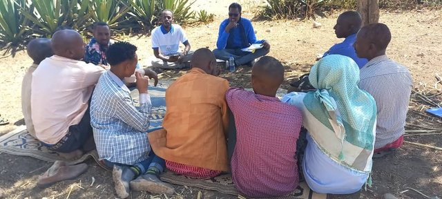
- field visits, field surveys
Four individuals
- interviews with SLM specialists/ experts
Two individuals.
When were the data compiled (in the field)?
23/03/2023
Comments:
The flash flood post three years of drought is so damaging. The fragile soil that has been exposed to the sun is easily detached and moved away by the flood. Substantial tons of soil stopped by the check dam signals the positive effects of the structure in changing the trends.
7.2 References to available publications
Title, author, year, ISBN:
Criteria for optimizing check dam location and maintenance requirements. Hassanli, A. M. & Beecham. 2013; ISBN: 971-1-60876-146-3
Available from where? Costs?
https://www.researchgate.net/publication/287636490_Criteria_for_optimizing_check_dam_location_and_maintenance_requirements
7.3 Links to relevant online information
Title/ description:
Different Types of Check Dams & Design Procedures
URL:
https://forestrybloq.com/different-types-of-check-dams/
7.4 General comments
The questionnaire is comprehensive. However, to answer every question, there must be a tradition of long-term data collection and documentation exercises by either the project or the partners government organizations. In that way, it is possible to fully address the multifaceted demands included in the questionnaires such as " the before and after SLM intervention" which is dire to address them for those projects at their early stages of implementation.
Links and modules
Expand all Collapse allLinks
Participatory Rehabilitation of Dry Valleys [Ethiopia]
Participatory rehabilitation and productive use of dry valleys is an approach employed to rehabilitate degraded and degradable land. It is operationalised through the Lowland Soil Rehabilitation Project with local development partners from kebele, district, regional agricultural bureaus, and other relevant stakeholders.
- Compiler: GERBA LETA
Modules
No modules