Springshed Revival through Trenches and Checkdams [Bhutan]
- Creation:
- Update:
- Compiler: Karma Wangdi
- Editor: Haka Drukpa
- Reviewers: William Critchley, Rima Mekdaschi Studer
Chhu Kayi Sa Khong Nyamsuung (ཆུ་རྐའི་ས་ཁོངས་ཉམས་སྲུང་།)
technologies_6853 - Bhutan
View sections
Expand all Collapse all1. General information
1.2 Contact details of resource persons and institutions involved in the assessment and documentation of the Technology
Key resource person(s)
SLM specialist:
Tenzin Kinkhen
Agriculture Extension Supervisor, Shaba Geog. Paro.
Bhutan
land user:
Dorji Chencho
n/a
Bhutan
Name of project which facilitated the documentation/ evaluation of the Technology (if relevant)
Strengthening national-level institutional and professional capacities of country Parties towards enhanced UNCCD monitoring and reporting – GEF 7 EA Umbrella II (GEF 7 UNCCD Enabling Activities_Umbrella II)Name of the institution(s) which facilitated the documentation/ evaluation of the Technology (if relevant)
National Soil Services Centre (National Soil Services Centre) - Bhutan1.3 Conditions regarding the use of data documented through WOCAT
The compiler and key resource person(s) accept the conditions regarding the use of data documented through WOCAT:
Yes
1.4 Declaration on sustainability of the described Technology
Is the Technology described here problematic with regard to land degradation, so that it cannot be declared a sustainable land management technology?
No
2. Description of the SLM Technology
2.1 Short description of the Technology
Definition of the Technology:
Springshed revival through trenches and check dams is associated with a nature-based solution approach to reviving more than 20 springsheds. These were widened with the occasional construction of check dams to prevent rill erosion from the newly revived spring waters.
2.2 Detailed description of the Technology
Description:
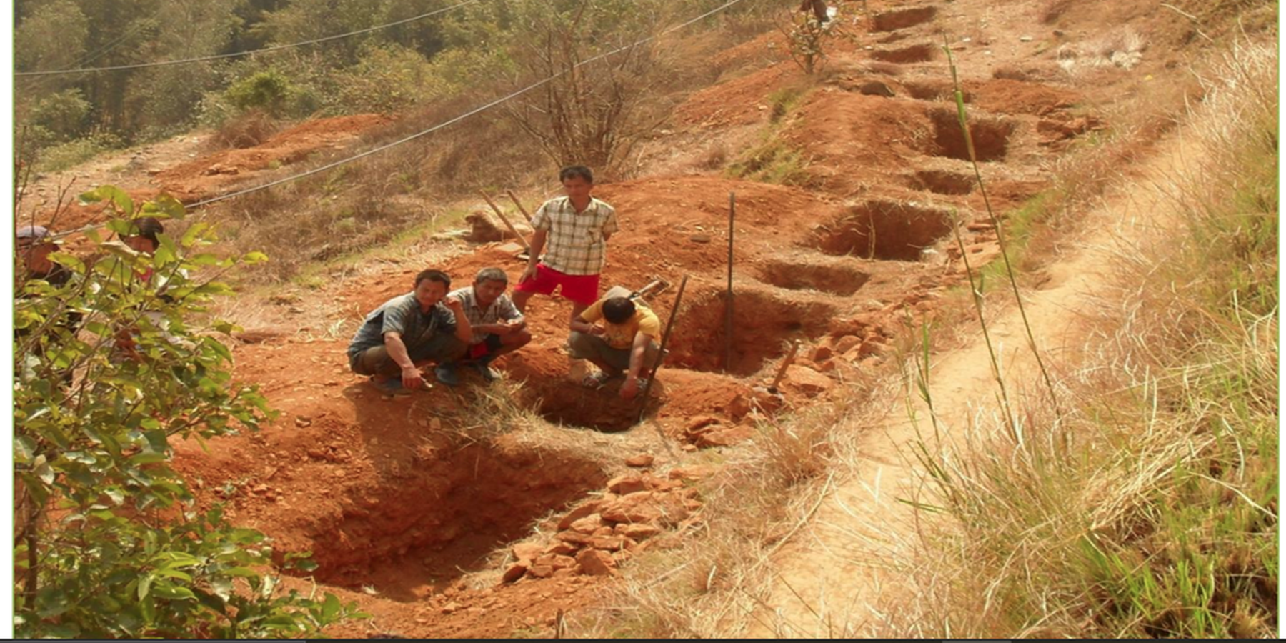
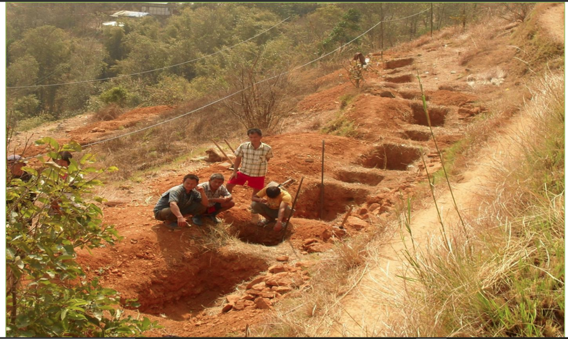
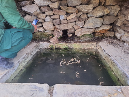
Trenches and check dams play a vital role in the implementation of the springshed revival technology in the picturesque hilly village of Lholing. This innovative approach to rejuvenating springsheds has extended its reach from the lush pasturelands above the village all the way down to the very first household of Lholing, resulting in the construction of approximately 20 ponds of varying sizes, replenished by springsheds. In some instances, the creation and expansion of these springsheds required the utilisation of mechanical excavators, emphasising the magnitude of the project.
The revitalised springsheds now produce an array of springs, each contributing water that eventually converges into a common tributary meandering towards the village. This valuable water is collected and stored in purposefully constructed water harvesting ponds, serving as a reliable source for kitchen garden irrigation and cattle feeding. While the primary objective was to address the pressing issue of drinking water scarcity in the community, it also yielded secondary benefits. These encompassed the provision of a drinking water source for the wildlife inhabiting the area, as well as supporting the irrigation needs of the kitchen garden. The implementation of check dams yielded additional advantages by mitigating rill and gully erosion and serving as effective filters for muddy spring water. This sustainable land management strategy was accomplished through a series of distinct activities. Firstly, an exhaustive survey and assessment of the springshed area was conducted to identify suitable locations for trenches and check dams. This process took into account factors such as the topography of the terrain, the hydrological dynamics, and the composition of the soil. Subsequently, a comprehensive plan and design was developed for the trenches and check dams, including their dimensions, spacing, and alignment. The involvement of experts and stakeholders during this stage ensured that the chosen design was optimal in terms of its effectiveness (Sameul, 2008).
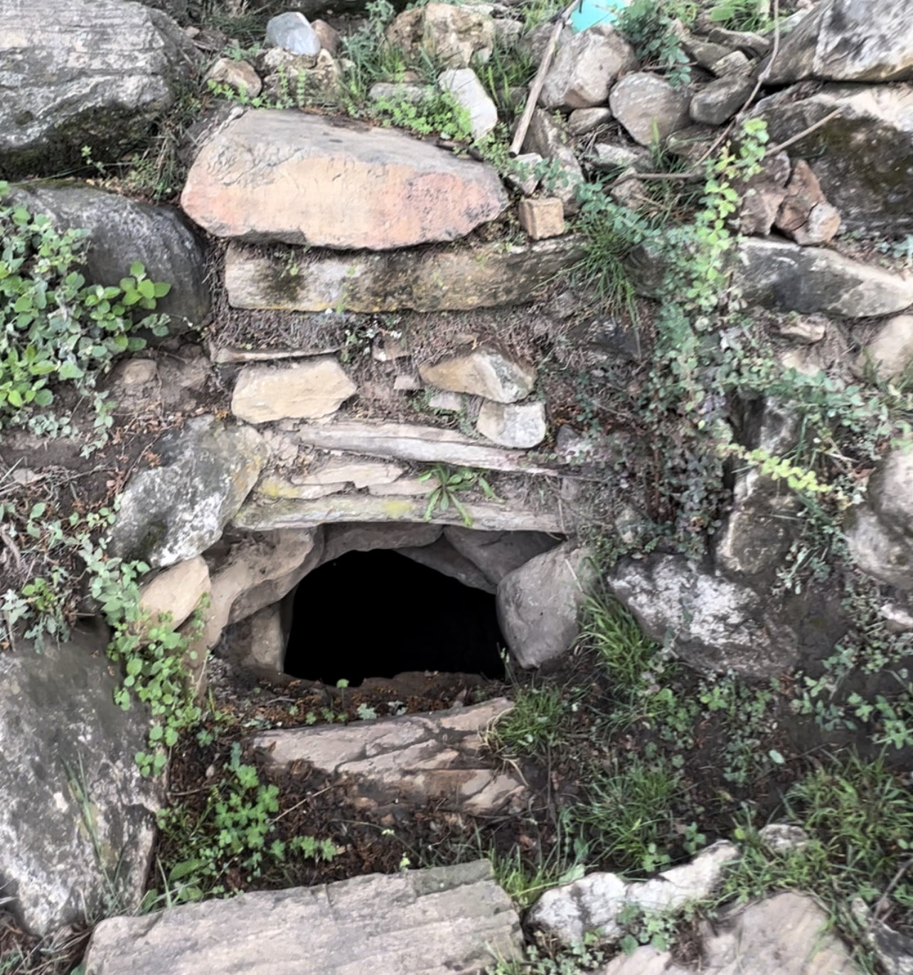
The execution phase involved the excavation and shaping of the trenches according to the design, followed by the construction of check dams. Trenching are required in open areas (where there is no vegetation cover) to trap surface runoff and enhance infiltration. Trenches can be dug along contour lines in a staggered or continuous pattern. However, the size of the trench is determined based on the site conditions. The number of trenches/pits depends on size, annual precipitation and the slope gradient of the recharge area in smaller area. Wedge shaped trenches are recommended for open areas while staggered or continuous trenches are recommended on slopy areas. Trenches are recommended in larger open area, while pits these check dams were specifically devised to retain water and control its flow. As part of gully treatment and to increase water infiltration, check dams are constructed. Typically, walls or barriers were built using locally available materials such as stone, wood, or concrete.
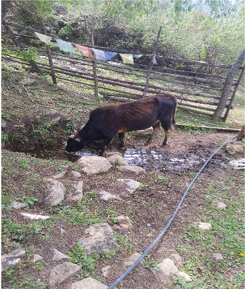
The advantages and benefits derived from this technology are manifold. In addition to the aforementioned advantages associated with springsheds, the implementation of trenches and check dams significantly contributed to the preservation and conservation of the fertile topsoil, preventing its degradation and erosion. The land users in the village expressed contentment with the successful revival of the springsheds, recognising their multifaceted contributions. Furthermore, they were duly impressed by the check dams' efficacy in preventing soil erosion and their ability to filter muddy water, ensuring a reliable and clean water supply (RSPN, 2023).
The creation of the ponds was especially appreciated as they served as a convenient water source for grazing cattle in the nearby jungle. However, despite the numerous benefits, there was a sense of dissatisfaction among many villagers due to the increasing number of wild animals, including wild boar and deer that frequented the ponds to quench their thirst. This unexpected influx of wildlife posed a significant threat to farms located in close proximity to the open springsheds.
2.3 Photos of the Technology
Media Gallery
2.4 Videos of the Technology
Comments, short description:
n/a
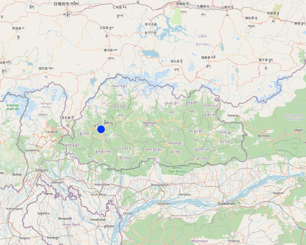
2.5 Country/ region/ locations where the Technology has been applied and which are covered by this assessment
Country:
Bhutan
Region/ State/ Province:
Paro
Further specification of location:
Shaba, Lholing.
Specify the spread of the Technology:
- applied at specific points/ concentrated on a small area
Is/are the technology site(s) located in a permanently protected area?
No
Comments:
The technology does not interfere with any protected areas.
Map
×2.6 Date of implementation
Indicate year of implementation:
2017
If precise year is not known, indicate approximate date:
- less than 10 years ago (recently)
2.7 Introduction of the Technology
Specify how the Technology was introduced:
- through projects/ external interventions
3. Classification of the SLM Technology
3.1 Main purpose(s) of the Technology
- conserve ecosystem
- protect a watershed/ downstream areas – in combination with other Technologies
- preserve/ improve biodiversity
- create beneficial economic impact
- To find another alternative source of water for cattle, laundry and other washing alternatives.
3.2 Current land use type(s) where the Technology is applied
Land use mixed within the same land unit:
No

Cropland
- Annual cropping
Annual cropping - Specify crops:
- cereals - rice (wetland)
Number of growing seasons per year:
- 1
Is intercropping practiced?
Yes
If yes, specify which crops are intercropped:
Chilli intercropped with brinjal and beans.
Is crop rotation practiced?
Yes
If yes, specify:
Paddy harvest follows by winter vegetables such as broccoli and cabbage plantations.

Grazing land
Extensive grazing:
- Ranching
Intensive grazing/ fodder production:
- Cut-and-carry/ zero grazing
Animal type:
- cattle - dairy
Is integrated crop-livestock management practiced?
Yes
If yes, specify:
Farmyard manures are applied in the fields.
Species:
cattle - dairy

Waterways, waterbodies, wetlands
- Ponds, dams
- Swamps, wetlands
Main products/ services:
Many small patches of wetlands are there.
3.3 Has land use changed due to the implementation of the Technology?
Has land use changed due to the implementation of the Technology?
- No (Continue with question 3.4)
3.4 Water supply
Water supply for the land on which the Technology is applied:
- mixed rainfed-irrigated
3.5 SLM group to which the Technology belongs
- water harvesting
- surface water management (spring, river, lakes, sea)
- ground water management
3.6 SLM measures comprising the Technology

structural measures
- S2: Bunds, banks
- S4: Level ditches, pits
- S7: Water harvesting/ supply/ irrigation equipment
3.7 Main types of land degradation addressed by the Technology

soil erosion by water
- Wt: loss of topsoil/ surface erosion

water degradation
- Hq: decline of groundwater quality
3.8 Prevention, reduction, or restoration of land degradation
Specify the goal of the Technology with regard to land degradation:
- prevent land degradation
- reduce land degradation
4. Technical specifications, implementation activities, inputs, and costs
4.1 Technical drawing of the Technology
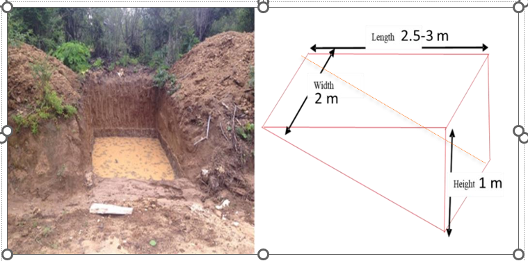
Technical specifications (related to technical drawing):
Design for the trenches as adapted from spring revival pilot site at Lholing, Paro
Author:
Water management Division
Date:
12/07/2023
4.2 General information regarding the calculation of inputs and costs
Specify how costs and inputs were calculated:
- per Technology unit
other/ national currency (specify):
Bhutanese Currency (Ngultrum)
If relevant, indicate exchange rate from USD to local currency (e.g. 1 USD = 79.9 Brazilian Real): 1 USD =:
82.25
Indicate average wage cost of hired labour per day:
700
4.3 Establishment activities
| Activity | Timing (season) | |
|---|---|---|
| 1. | conducting a thorough survey and assessment in spring shed area | - |
| 2. | Develop a comprehensive plan and design for the check dams and trenches. | - |
| 3. | Gathering of labor and constructing materials. | - |
| 4. | Excavate the trenches according to the planned design and shape the trenches to facilitate proper water flow and retention. | started in March |
| 5. | Build check dams across the trenches to impound water and control its flow. | - |
| 6. | Install the check dams in the designated locations along the trenches and ensure proper alignment and stability of the structures | - |
| 7. | Regularly monitor the check dams and trenches for any signs of damage or erosion. | - |
4.4 Costs and inputs needed for establishment
| Specify input | Unit | Quantity | Costs per Unit | Total costs per input | % of costs borne by land users | |
|---|---|---|---|---|---|---|
| Labour | labour | person | 22.0 | 700.0 | 15400.0 | |
| Labour | Technical Person (Forester) | person | 8.0 | 1500.0 | 12000.0 | |
| Equipment | Excavator | number | 1.0 | 15000.0 | 15000.0 | |
| Equipment | Barbed wire | meter | 2.0 | 5500.0 | 11000.0 | |
| Equipment | Tarpauline sheet | meter | 2.0 | 4200.0 | 8400.0 | |
| Construction material | Mud | |||||
| Construction material | Boulders | |||||
| Total costs for establishment of the Technology | 61800.0 | |||||
| Total costs for establishment of the Technology in USD | 751.37 | |||||
If land user bore less than 100% of costs, indicate who covered the remaining costs:
The cost was borne 100 % by the government.
Comments:
The machines was state owned property with least charges and cost estimated was only for the single structure. In case of Lholing several structures were constructed hoping for the spring revival.
4.5 Maintenance/ recurrent activities
| Activity | Timing/ frequency | |
|---|---|---|
| 1. | Farmers Gathering | Thrice (spring, Summer, winter) |
| 2. | visiting each of the constructed site and they removed the sedimented particles in the trenches. | Thrice( before onset of monsoon season |
| 3. | Substituting the worn out plastic if in case it was damaged | once |
4.6 Costs and inputs needed for maintenance/ recurrent activities (per year)
| Specify input | Unit | Quantity | Costs per Unit | Total costs per input | % of costs borne by land users | |
|---|---|---|---|---|---|---|
| Labour | Farmers | person | 22.0 | 100.0 | ||
| Equipment | spade and shovel | numbers | 10.0 | 100.0 |
If you are unable to break down the costs in the table above, give an estimation of the total costs of maintaining the Technology:
3.0
Comments:
According the information given by a locality, the maintenance was coordinated and done by the local community with labour service without costing single penny.
4.7 Most important factors affecting the costs
Describe the most determinate factors affecting the costs:
The most important factor that contributed to the huge cost was from machine hiring charges. The community usually cost minimum of Nu. 15000 in an hour and some of them can hire it counting the number of days.
5. Natural and human environment
5.1 Climate
Annual rainfall
- < 250 mm
- 251-500 mm
- 501-750 mm
- 751-1,000 mm
- 1,001-1,500 mm
- 1,501-2,000 mm
- 2,001-3,000 mm
- 3,001-4,000 mm
- > 4,000 mm
Specifications/ comments on rainfall:
The area experienced low rainfall being in the cool temperate region.
Indicate the name of the reference meteorological station considered:
Weather station, Paro
Agro-climatic zone
The area falls on Cool Temperate region as per the Agro-ecological Zones of Bhutan
5.2 Topography
Slopes on average:
- flat (0-2%)
- gentle (3-5%)
- moderate (6-10%)
- rolling (11-15%)
- hilly (16-30%)
- steep (31-60%)
- very steep (>60%)
Landforms:
- plateau/plains
- ridges
- mountain slopes
- hill slopes
- footslopes
- valley floors
Altitudinal zone:
- 0-100 m a.s.l.
- 101-500 m a.s.l.
- 501-1,000 m a.s.l.
- 1,001-1,500 m a.s.l.
- 1,501-2,000 m a.s.l.
- 2,001-2,500 m a.s.l.
- 2,501-3,000 m a.s.l.
- 3,001-4,000 m a.s.l.
- > 4,000 m a.s.l.
Indicate if the Technology is specifically applied in:
- not relevant
5.3 Soils
Soil depth on average:
- very shallow (0-20 cm)
- shallow (21-50 cm)
- moderately deep (51-80 cm)
- deep (81-120 cm)
- very deep (> 120 cm)
Soil texture (topsoil):
- medium (loamy, silty)
Soil texture (> 20 cm below surface):
- coarse/ light (sandy)
Topsoil organic matter:
- medium (1-3%)
5.4 Water availability and quality
Ground water table:
on surface
Availability of surface water:
medium
Water quality (untreated):
good drinking water
Water quality refers to:
both ground and surface water
Is water salinity a problem?
No
Is flooding of the area occurring?
No
5.5 Biodiversity
Species diversity:
- medium
Habitat diversity:
- medium
5.6 Characteristics of land users applying the Technology
Sedentary or nomadic:
- Sedentary
Market orientation of production system:
- mixed (subsistence/ commercial)
Off-farm income:
- less than 10% of all income
Relative level of wealth:
- average
Individuals or groups:
- individual/ household
Level of mechanization:
- mechanized/ motorized
Gender:
- women
Age of land users:
- middle-aged
Indicate other relevant characteristics of the land users:
The land users of those places own two residences, when the extreme weather conditions occurred they move to lower land. The crises of cold winter and water scarcity were the highlighted issues faced by the farmers.
5.7 Average area of land used by land users applying the Technology
- < 0.5 ha
- 0.5-1 ha
- 1-2 ha
- 2-5 ha
- 5-15 ha
- 15-50 ha
- 50-100 ha
- 100-500 ha
- 500-1,000 ha
- 1,000-10,000 ha
- > 10,000 ha
Is this considered small-, medium- or large-scale (referring to local context)?
- small-scale
Comments:
The local people said that Lholing farmers owned an average of 0.5 hectare.
5.8 Land ownership, land use rights, and water use rights
Land ownership:
- individual, titled
Land use rights:
- individual
Water use rights:
- communal (organized)
Are land use rights based on a traditional legal system?
No
5.9 Access to services and infrastructure
health:
- poor
- moderate
- good
education:
- poor
- moderate
- good
technical assistance:
- poor
- moderate
- good
employment (e.g. off-farm):
- poor
- moderate
- good
markets:
- poor
- moderate
- good
energy:
- poor
- moderate
- good
roads and transport:
- poor
- moderate
- good
drinking water and sanitation:
- poor
- moderate
- good
financial services:
- poor
- moderate
- good
Comments:
The farmers of Lholing have to avail services like bank, health, technical assistance and education in Shaba as the households were less to get the government support.
6. Impacts and concluding statements
6.1 On-site impacts the Technology has shown
Socio-economic impacts
Water availability and quality
drinking water availability
Comments/ specify:
In winter the spring water could be also used for drinking purposes.
This is expert estimates
water availability for livestock
Comments/ specify:
The water availability drastically increased for the livestock feeding through direct supply from the springshed ponds or spring water collected near the village in water harvesting pond. This is expert estimates
irrigation water availability
Comments/ specify:
Available Irrigation water for both wetland and kitchen garden are drastically improved with springshed. This is expert estimates
Socio-cultural impacts
health situation
Comments/ specify:
Improved with improved hygiene. This is expert estimates
conflict mitigation
Comments/ specify:
Reduced water related conflicts. This is expert estimates
Ecological impacts
Water cycle/ runoff
water quantity
Comments/ specify:
This is expert estimates
harvesting/ collection of water
Comments/ specify:
This is expert estimates
surface runoff
Comments/ specify:
Surface run-off especially during monsoon is drastically reduced with both trenches and check dams.This is expert estimates
6.2 Off-site impacts the Technology has shown
water availability
Comments/ specify:
The technology has been beneficial for the near by spring revival
reliable and stable stream flows in dry season
Comments/ specify:
The effect wasn't effective when water source was totally dried up during the winter
downstream flooding
Comments/ specify:
No effect at all
downstream siltation
groundwater/ river pollution
buffering/ filtering capacity
Comments/ specify:
Checkdams sometimes served as a filtration for the residue and reduces the velocity of flow
wind transported sediments
damage on neighbours' fields
damage on public/ private infrastructure
Comments/ specify:
No damage has been recorded after an application of the technology
impact of greenhouse gases
Specify assessment of off-site impacts (measurements):
Assessment of off site impact is mainly done through field monitoring and evaluations
6.3 Exposure and sensitivity of the Technology to gradual climate change and climate-related extremes/ disasters (as perceived by land users)
Gradual climate change
Gradual climate change
| Season | increase or decrease | How does the Technology cope with it? | |
|---|---|---|---|
| annual temperature | increase | moderately | |
| annual rainfall | decrease | moderately |
Climate-related extremes (disasters)
Meteorological disasters
| How does the Technology cope with it? | |
|---|---|
| local snowstorm | not well |
Climatological disasters
| How does the Technology cope with it? | |
|---|---|
| extreme winter conditions | not well |
Hydrological disasters
| How does the Technology cope with it? | |
|---|---|
| flash flood | well |
6.4 Cost-benefit analysis
How do the benefits compare with the establishment costs (from land users’ perspective)?
Short-term returns:
neutral/ balanced
Long-term returns:
positive
How do the benefits compare with the maintenance/ recurrent costs (from land users' perspective)?
Short-term returns:
neutral/ balanced
Long-term returns:
positive
6.5 Adoption of the Technology
- single cases/ experimental
If available, quantify (no. of households and/ or area covered):
Almost 20 individuals household has participated in implementation of the technology
Of all those who have adopted the Technology, how many did so spontaneously, i.e. without receiving any material incentives/ payments?
- 0-10%
6.6 Adaptation
Has the Technology been modified recently to adapt to changing conditions?
No
6.7 Strengths/ advantages/ opportunities of the Technology
| Strengths/ advantages/ opportunities in the land user’s view |
|---|
| Water availability to some extent was helpful |
| Farming and irrigation support |
| Strengths/ advantages/ opportunities in the compiler’s or other key resource person’s view |
|---|
| Underground water recharge |
| Water conservation |
| Flood mitigation |
6.8 Weaknesses/ disadvantages/ risks of the Technology and ways of overcoming them
| Weaknesses/ disadvantages/ risks in the land user’s view | How can they be overcome? |
|---|---|
| Need huge labor contribution. | Each of the household should be well coordinated |
| Need huge investment. | The support from government and other grants can be helpful. |
| Weaknesses/ disadvantages/ risks in the compiler’s or other key resource person’s view | How can they be overcome? |
|---|---|
| Is the long process and immediate result cannot be seen. | Can continue for the longer duration. |
| Sediment buildup. | Need constant removal. |
| Environmental impacts. | Good research and planning |
7. References and links
7.1 Methods/ sources of information
- field visits, field surveys
1
- interviews with land users
1
When were the data compiled (in the field)?
13/07/2023
7.2 References to available publications
Title, author, year, ISBN:
Sameul, M. P. (2008). Rejuvenation of water bodies by adopting rainwater harvesting and groundwater recharging practices in catchment area-a case study
Available from where? Costs?
Google Scholar
Title, author, year, ISBN:
RSPN. (2023). Introduction of Check-dams in Wamrong.
Available from where? Costs?
Free website
7.3 Links to relevant online information
Title/ description:
Rejuvenation of water bodies by adopting rainwater harvesting and groundwater recharging practices in catchment area-a case study.
URL:
https://doi.org/10.1016/j.jenvman.2020.111679
Title/ description:
Introduction of Check-dams in Wamrong.
URL:
https://www.rspnbhutan.org/introduction-of-check-dams-in-wamrong/
7.4 General comments
Although water scarcity remains an issue at Lholing, the implementation of this technology is intended to provide a solution.
Links and modules
Expand all Collapse allLinks
No links
Modules
No modules