Tree Plantation Pits in Arid Zones [Saudi Arabia]
- Creation:
- Update:
- Compiler: Eric Lacroix
- Editor: –
- Reviewers: William Critchley, Rima Mekdaschi Studer
Plantation pits
technologies_7380 - Saudi Arabia
View sections
Expand all Collapse all1. General information
1.2 Contact details of resource persons and institutions involved in the assessment and documentation of the Technology
land user:
Al Eissa Abdullah
NCVC
Saudi Arabia
co-compiler:
co-compiler:
SLM specialist:
Boudi Dr. Nabeel
FAO
Saudi Arabia
Name of project which facilitated the documentation/ evaluation of the Technology (if relevant)
Sustainable Rural Agricultural Development Programme (UTF/SAU/051/SAU) (SRAD Saudi Arabia)Name of the institution(s) which facilitated the documentation/ evaluation of the Technology (if relevant)
FAO Saudi Arabia (FAO KSA)1.3 Conditions regarding the use of data documented through WOCAT
The compiler and key resource person(s) accept the conditions regarding the use of data documented through WOCAT:
Yes
1.4 Declaration on sustainability of the described Technology
Is the Technology described here problematic with regard to land degradation, so that it cannot be declared a sustainable land management technology?
No
Comments:
This method allows sustainable plantations with a satisfactory level of success in hyper-arid zones (under 100 mm rainfall per year).
2. Description of the SLM Technology
2.1 Short description of the Technology
Definition of the Technology:
Tree plantation pits are water harvesting structures which capture rainfall runoff for trees and shrubs. They receive supplementary water until seedlings are well established. Species planted are indigenous, and provide both shade and honey.
2.2 Detailed description of the Technology
Description:
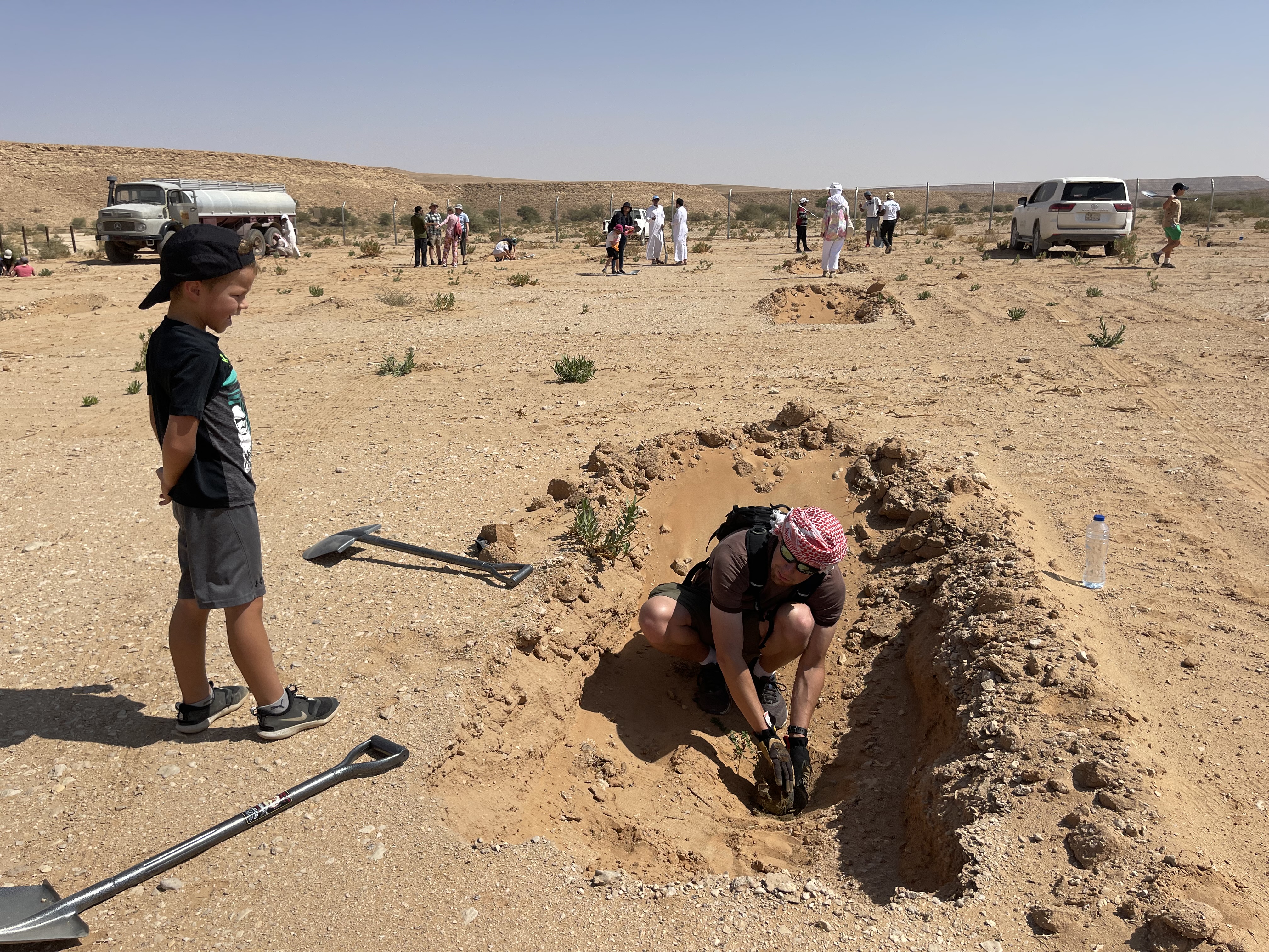
Plantation pits are water harvesting structures that capture rainfall runoff for planting trees and shrubs. They are given supplementary water until vegetation is established. The pits are dug within national parks managed by the National Centre for Vegetation Cover Development and Combating Desertification (NCVC), which is the leader in this technology.
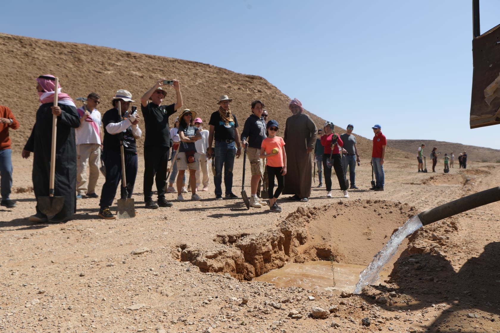
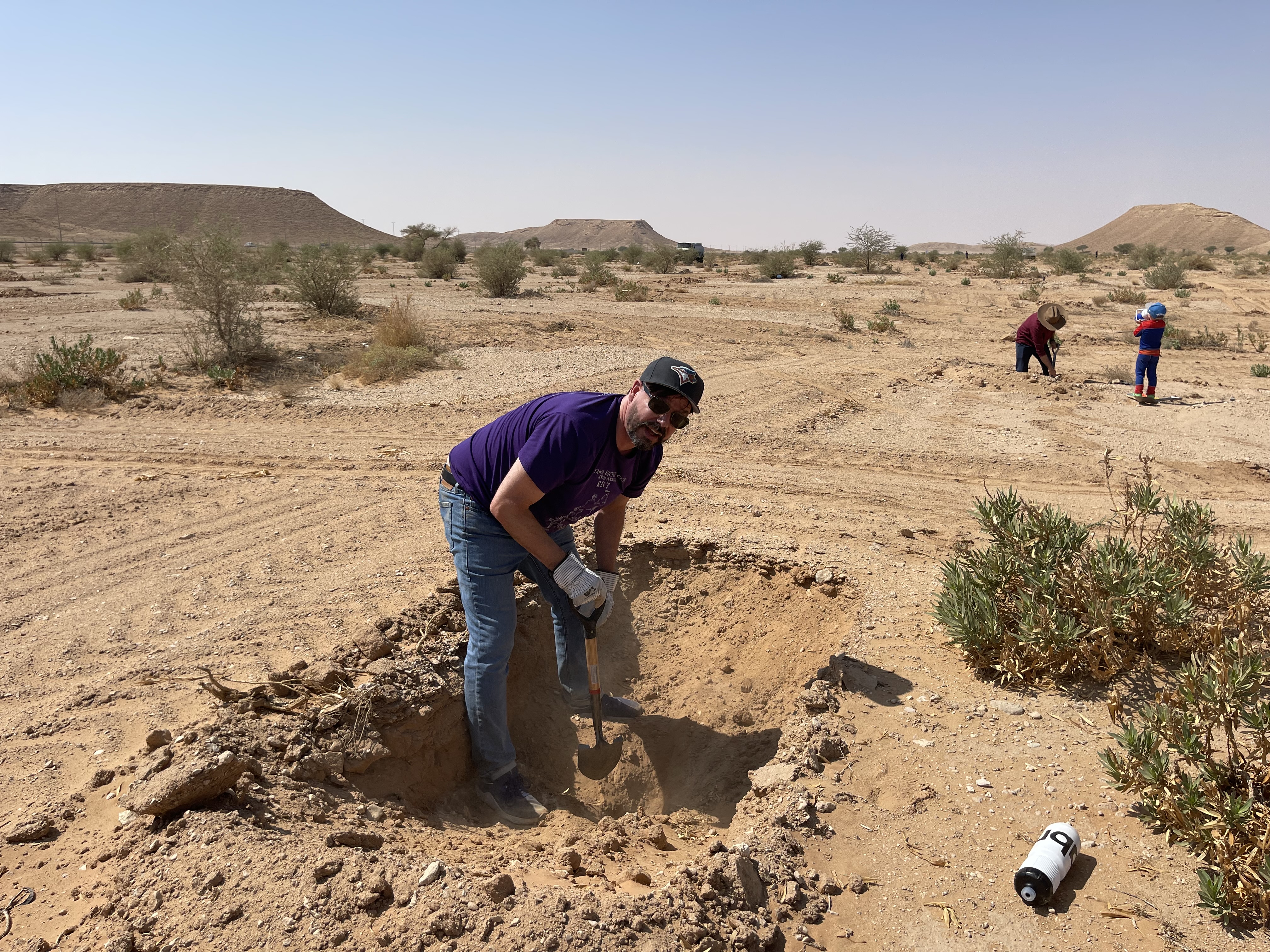
Pits may be located within wadis and sheyhib (small wadis), ranging in plots from ten to several hundred metres in length, and on high plateaux. The pits are often dug close to terraces and cross-wadi walls where runoff water is captured in the soil. Each plantation pit is rectangular, measuring (approx) 2m long, 1m wide, and up to 1m deep (depending on the depth of the soil). Spacing is from 3 to 10 metres between pits. The pits are excavated with mechanical diggers.
Pits are dug a year before planting, and they collect both runoff and the rich organic and mineral matter carried in the runoff. After one year, many annual and even perennial plants colonise the bottom of the pits. The trees and shrubs that are planted the most are Vachellia (Acacia) spp., Ziziphus spp. and Haxloylon spp. One (or two) seedlings are planted in the middle of each pit, without disturbing the existing vegetation as far as possible. These species attract bees, and beekeeping has been promoted alongside tree planting. Ziziphus honey is particularly high in value and Vachellia (acacia) honey is also good.
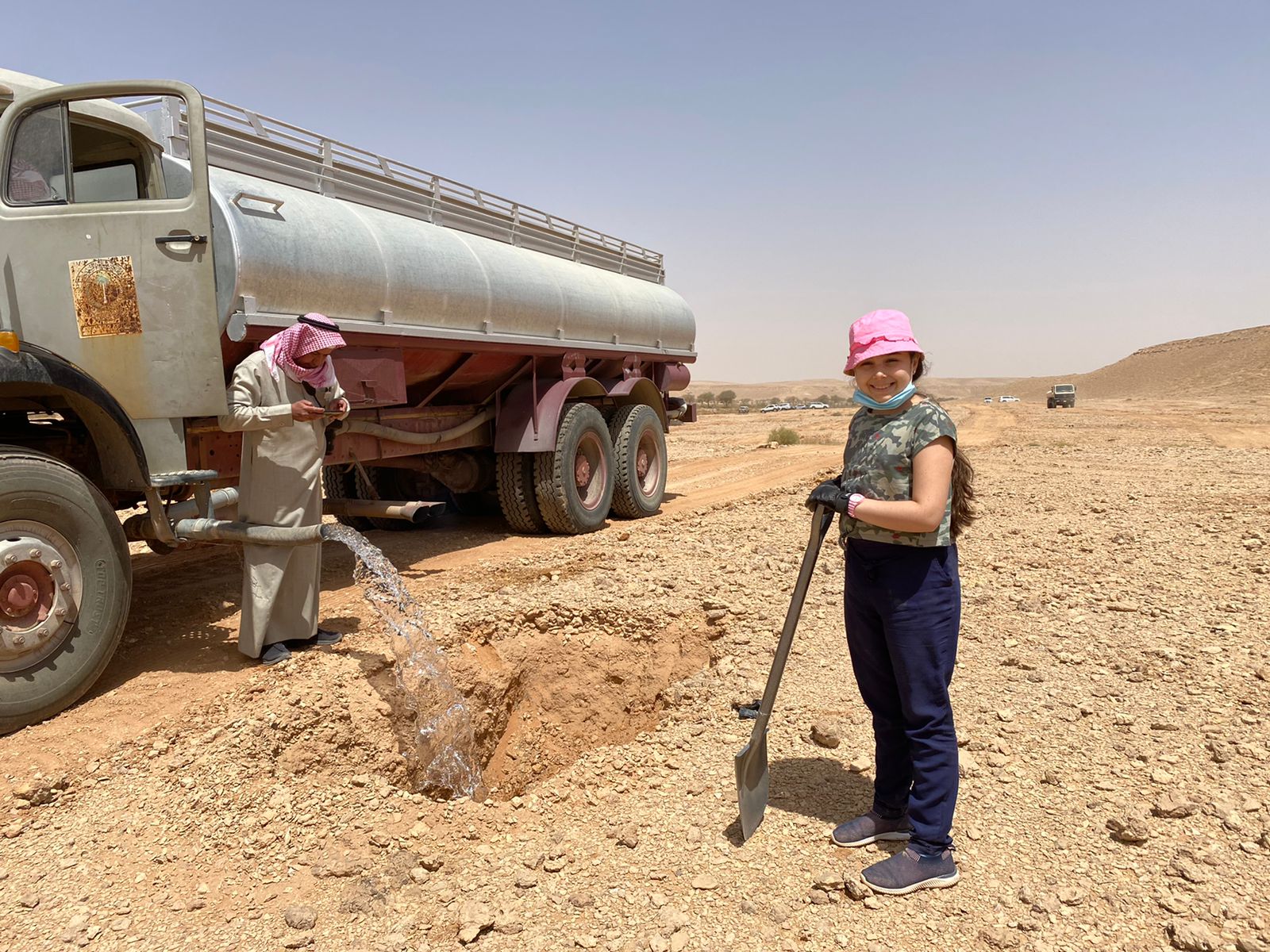
This water and nutrient harvesting technique is effective even in hyper-arid conditions, where rainfall may be less than 100 mm yearly. However, some supplemental irrigation is needed, and each pit is watered - every 4 months over 3 years - with a volume of water ranging from 20 to 100 litres each time per pit, depending on availability. Water is found in wadi beds and brought to the site in a bowser mounted on a lorry. Watering helps the plants to survive, and as it penetrates, it draws the roots down until they reach the water table. This is when watering can be stopped.
Although the costs are high, the results are generally very satisfactory regarding the survival rate. The local impact is significant when there are large blocks of pits and/ or greater numbers of pits per hectare (where this is possible). Over the last five years, a million pits have been dug.
Abdulla Al Eissa, the park manager, formulated the technical design of the pits, and FAO through the project "Strengthening MoEWA's Capacity to implement its Sustainable Rural Agricultural Development (SRAD) Programme (2019-2025) UTF/SAU/051/SAU" has been responsible for technical advice on locating pits, spacing and layout timing of operations, fertilization and planting operations. The activities are part-funded by the NCVC, while local donors and volunteers contribute the remainder.
2.3 Photos of the Technology
Media Gallery
2.4 Videos of the Technology
Comments, short description:
https://vimeo.com/1026092452?share=copy
Date:
04/11/2024
Location:
Thadiq national park
Name of videographer:
Abdullah Al Eissa
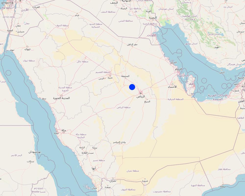
2.5 Country/ region/ locations where the Technology has been applied and which are covered by this assessment
Country:
Saudi Arabia
Region/ State/ Province:
Riyadh Region (Province)
Further specification of location:
Thadiq National Park
Specify the spread of the Technology:
- evenly spread over an area
If the Technology is evenly spread over an area, specify area covered (in km2):
148.0
If precise area is not known, indicate approximate area covered:
- 100-1,000 km2
Is/are the technology site(s) located in a permanently protected area?
Yes
If yes, specify:
Dispersed within Thadiq National Park
Comments:
This is a protected area (category V), IUCN, not yet registered in WDPA, 145 SQKM. This protected area is within the North Riyadh Geopark UNESCO (3000 SQKM). In the future, the National Park may extend and become a IUCN Protected area Category II.
Map
×2.6 Date of implementation
Indicate year of implementation:
2019
If precise year is not known, indicate approximate date:
- less than 10 years ago (recently)
2.7 Introduction of the Technology
Specify how the Technology was introduced:
- through projects/ external interventions
Comments (type of project, etc.):
Pits are established under a project which sets out to develop vegetation to protect the environment in the National Parks and to support tourism in the region, partly financed by the NCVC (paying for workmen's salaries, etc. ) and local donors (trucks, machines) and volunteers planting.
3. Classification of the SLM Technology
3.1 Main purpose(s) of the Technology
- reduce, prevent, restore land degradation
- conserve ecosystem
- preserve/ improve biodiversity
- create beneficial economic impact
- create beneficial social impact
3.2 Current land use type(s) where the Technology is applied
Land use mixed within the same land unit:
No

Forest/ woodlands
- (Semi-)natural forests/ woodlands
- Tree plantation, afforestation
(Semi-)natural forests/ woodlands: Specify management type:
- Non-wood forest use
Type of (semi-)natural forest:
- subtropical dry forest natural vegetation
Tree plantation, afforestation: Specify origin and composition of species:
- Mixed varieties
Type of tree plantation, afforestation:
- subtropical dry forest plantation
- subtropical dry forest plantation - Broadleaf
Type of tree:
- Acacia species
- Acacia tortilis
- Ziziphus mauritiana
- Balanites aegyptiaca
Are the trees specified above deciduous or evergreen?
- deciduous
Products and services:
- Nature conservation/ protection
- Recreation/ tourism
- Protection against natural hazards
Comments:
The Royal Botanical Garden Kew's Plants of the World website now uses the name Vachellia for the genus formerly known as Acacia.
3.3 Has land use changed due to the implementation of the Technology?
Has land use changed due to the implementation of the Technology?
- Yes (Please fill out the questions below with regard to the land use before implementation of the Technology)

Unproductive land
3.4 Water supply
Water supply for the land on which the Technology is applied:
- mixed rainfed-irrigated
Comments:
Supplementary water sourced from wadi beds (3 deep wells with electrical pumps).
3.5 SLM group to which the Technology belongs
- natural and semi-natural forest management
- water harvesting
- beekeeping, aquaculture, poultry, rabbit farming, silkworm farming, etc.
3.6 SLM measures comprising the Technology

vegetative measures
- V1: Tree and shrub cover

structural measures
- S4: Level ditches, pits
- S7: Water harvesting/ supply/ irrigation equipment
3.7 Main types of land degradation addressed by the Technology

soil erosion by water
- Wt: loss of topsoil/ surface erosion
- Wg: gully erosion/ gullying
- Wo: offsite degradation effects

physical soil deterioration
- Pk: slaking and crusting
- Pu: loss of bio-productive function due to other activities

biological degradation
- Bc: reduction of vegetation cover
- Bh: loss of habitats
- Bq: quantity/ biomass decline
- Bs: quality and species composition/ diversity decline
- Bl: loss of soil life

water degradation
- Ha: aridification
- Hs: change in quantity of surface water
- Hg: change in groundwater/aquifer level
- Hp: decline of surface water quality
- Hq: decline of groundwater quality
3.8 Prevention, reduction, or restoration of land degradation
Specify the goal of the Technology with regard to land degradation:
- reduce land degradation
4. Technical specifications, implementation activities, inputs, and costs
4.1 Technical drawing of the Technology
Technical specifications (related to technical drawing):
Each pit is 2 m long, 1m wide, up to 1m deep, spacing from 3 to 10 meters between structures in curved lines, or 3 meters apart in clusters. Watering with 20 to 100 litres depending on the availability and price of water and cost of transportation and watering. 100 pits minimum per hectare (maximum 1100, which is rare in this environment). One to three seedlings (tree, shrub, plant) per pit.
Author:
Éric Lacroix,
Date:
04/11/2024
Technical specifications (related to technical drawing):
Watering system: truck with bowser (tank) and hose
Author:
ChatGPT based on an image and explanations.
Date:
04/05/2025
Technical specifications (related to technical drawing):
Between lines and between pits: 3-10 meters. In lines or in curves or at random.
Author:
ChatGPT based on an image and instructions.
Date:
06/05/2025
4.2 General information regarding the calculation of inputs and costs
Specify how costs and inputs were calculated:
- per Technology area
Indicate size and area unit:
hectare with 100 pits
Specify currency used for cost calculations:
- USD
Indicate average wage cost of hired labour per day:
33-50 dollars
4.3 Establishment activities
| Activity | Timing (season) | |
|---|---|---|
| 1. | Identify the site | Dry season: Year 1 |
| 2. | Layout and mark the pits with stakes | Dry season: Year 1 |
| 3. | Dig the pits | Dry season: Year 1 |
| 4. | Produce the seedlings in a nursery | Dry season: Year 1 |
| 5. | Plant the seedlings | Rainy season: Year 2 |
| 6. | Water the seedlings (and replace dead ones) | Dry season: Years 2-4 |
| 7. | Check the pits during the first rain. | Rainy season: Years 2-4 |
| 8. | Check the pits after flooding | After flooding: Years 2-4 |
Comments:
Based on a 4 year period - with trees seedlings planted 1 year after the pits are dug.
4.4 Costs and inputs needed for establishment
| Specify input | Unit | Quantity | Costs per Unit | Total costs per input | % of costs borne by land users | |
|---|---|---|---|---|---|---|
| Labour | Workers for planting | Worker/day | 5.0 | 50.0 | 250.0 | 90.0 |
| Labour | Workers for watering | Worker/day | 18.0 | 33.0 | 594.0 | 90.0 |
| Equipment | Excavator for digging pits (2 x 2 x 1 m) 100 pits /ha | Hour | 25.0 | 93.0 | 2325.0 | 90.0 |
| Equipment | Truck with bowser/ tank for watering (100 litres /pit / 9 times over 3 years) | Truck/ 5000 litres | 18.0 | 47.0 | 846.0 | 90.0 |
| Plant material | Tree Seedlings 200 /ha | Seedling | 200.0 | 4.0 | 800.0 | |
| Total costs for establishment of the Technology | 4815.0 | |||||
| Total costs for establishment of the Technology in USD | 4815.0 | |||||
If land user bore less than 100% of costs, indicate who covered the remaining costs:
The costs are paid through the National Park: 90% from private donations/ volunteer work and 10% by the National Center for Vegetation Cover NCVC. Seedlings supplied by NCVC.
Comments:
The costs are spread over 4 years, by hectare, for 100 pits, including digging, planting - and watering for 3 years.
4.5 Maintenance/ recurrent activities
| Activity | Timing/ frequency | |
|---|---|---|
| 1. | Checking the pits after the first rain | Once, after the first rain. |
| 2. | Checking the pits after floodings | After flooding. |
| 3. | Replacing seedlings when needed (with extra watering if necessary). | During the wet season |
Comments:
Depending on the climate
4.6 Costs and inputs needed for maintenance/ recurrent activities (per year)
| Specify input | Unit | Quantity | Costs per Unit | Total costs per input | % of costs borne by land users | |
|---|---|---|---|---|---|---|
| Labour | Workers for maintenance including repairs, weeding and planting replacement seedlings | Worker/day | 10.0 | 50.0 | 500.0 | 100.0 |
| Plant material | Tree seedlings | seedling | 30.0 | 4.0 | 120.0 | |
| Total costs for maintenance of the Technology | 620.0 | |||||
| Total costs for maintenance of the Technology in USD | 620.0 | |||||
If land user bore less than 100% of costs, indicate who covered the remaining costs:
Local donors 100 % of workers costs and NCVC 100 % of the seedlings.
Comments:
Depending on the type of soil, drought and flooding. Figures are an average per year for first few years. Extra watering may be necessary at an extra cost for the truck/ bowser (not costed here).
4.7 Most important factors affecting the costs
Describe the most determinate factors affecting the costs:
Type of soil, drought and flooding.
5. Natural and human environment
5.1 Climate
Annual rainfall
- < 250 mm
- 251-500 mm
- 501-750 mm
- 751-1,000 mm
- 1,001-1,500 mm
- 1,501-2,000 mm
- 2,001-3,000 mm
- 3,001-4,000 mm
- > 4,000 mm
Specify average annual rainfall (if known), in mm:
70.00
Specifications/ comments on rainfall:
The distribution and seasonality of rainfall in Riyadh, Saudi Arabia, are characterized by low annual totals, high variability, and a distinct seasonal pattern associated with its arid desert climate.
Indicate the name of the reference meteorological station considered:
Internet, available climate data
Agro-climatic zone
- arid
Arid or hyper-arid, to be exact. Riyadh region, in general, experiences a hot desert climate. Summers are extremely hot, with temperatures often exceeding 45°C (113°F), while winters are mild, with daytime temperatures averaging around 20°C (68°F). Rainfall is scarce and irregular, mostly occurring between November and April, with an annual average of less than 100 mm.
5.2 Topography
Slopes on average:
- flat (0-2%)
- gentle (3-5%)
- moderate (6-10%)
- rolling (11-15%)
- hilly (16-30%)
- steep (31-60%)
- very steep (>60%)
Landforms:
- plateau/plains
- ridges
- mountain slopes
- hill slopes
- footslopes
- valley floors
Altitudinal zone:
- 0-100 m a.s.l.
- 101-500 m a.s.l.
- 501-1,000 m a.s.l.
- 1,001-1,500 m a.s.l.
- 1,501-2,000 m a.s.l.
- 2,001-2,500 m a.s.l.
- 2,501-3,000 m a.s.l.
- 3,001-4,000 m a.s.l.
- > 4,000 m a.s.l.
Indicate if the Technology is specifically applied in:
- not relevant
Comments and further specifications on topography:
This technology is specific to the Thuwayq wadis and plateaus
5.3 Soils
Soil depth on average:
- very shallow (0-20 cm)
- shallow (21-50 cm)
- moderately deep (51-80 cm)
- deep (81-120 cm)
- very deep (> 120 cm)
Soil texture (topsoil):
- coarse/ light (sandy)
Soil texture (> 20 cm below surface):
- coarse/ light (sandy)
Topsoil organic matter:
- low (<1%)
If available, attach full soil description or specify the available information, e.g. soil type, soil PH/ acidity, Cation Exchange Capacity, nitrogen, salinity etc.
Rocky limestone soils, sometimes sandy.
5.4 Water availability and quality
Ground water table:
5-50 m
Availability of surface water:
poor/ none
Water quality (untreated):
unusable
Water quality refers to:
ground water
Is water salinity a problem?
No
Is flooding of the area occurring?
Yes
Regularity:
episodically
Comments and further specifications on water quality and quantity:
One to three floodings a year.
5.5 Biodiversity
Species diversity:
- low
Habitat diversity:
- low
Comments and further specifications on biodiversity:
Arid ecosystems, low but relatively rich for the region.
5.6 Characteristics of land users applying the Technology
other (specify):
Various
Market orientation of production system:
- mixed (subsistence/ commercial)
Off-farm income:
- 10-50% of all income
Relative level of wealth:
- average
Individuals or groups:
- individual/ household
- employee (company, government)
Level of mechanization:
- mechanized/ motorized
Gender:
- women
- men
Age of land users:
- children
- youth
- middle-aged
- elderly
Indicate other relevant characteristics of the land users:
The land manager is the Government, National Centre for Vegetation Cover Development and Combating Desertification, which facilitates tourism/ picnicking in the park and protection of the environment (for all genders and ages of tourists). Land users can be considered to be local people who volunteer their labour and use the area for recreation.
5.7 Average area of land used by land users applying the Technology
- < 0.5 ha
- 0.5-1 ha
- 1-2 ha
- 2-5 ha
- 5-15 ha
- 15-50 ha
- 50-100 ha
- 100-500 ha
- 500-1,000 ha
- 1,000-10,000 ha
- > 10,000 ha
Comments:
Sizes of National Parks where such interventions are/ will be found
5.8 Land ownership, land use rights, and water use rights
Land ownership:
- state
- under park management
- under park management
Are land use rights based on a traditional legal system?
No
Comments:
National Park, government property
5.9 Access to services and infrastructure
education:
- poor
- moderate
- good
employment (e.g. off-farm):
- poor
- moderate
- good
Tourism:
- poor
- moderate
- good
Comments:
Tourism is with guides and tour operators - facilities are being improved
6. Impacts and concluding statements
6.1 On-site impacts the Technology has shown
Socio-economic impacts
Production
forest/ woodland quality
Comments/ specify:
Can double the vegetation cover in 10 years
Socio-cultural impacts
recreational opportunities
Comments/ specify:
Development of picnic and recreational areas once trees have grown
Ecological impacts
Water cycle/ runoff
water quantity
Comments/ specify:
Recharges the water table
surface runoff
groundwater table/ aquifer
Soil
soil moisture
soil cover
soil loss
soil accumulation
nutrient cycling/ recharge
Biodiversity: vegetation, animals
Vegetation cover
biomass/ above ground C
plant diversity
animal diversity
habitat diversity
Climate and disaster risk reduction
flood impacts
drought impacts
emission of carbon and greenhouse gases
micro-climate
Specify assessment of on-site impacts (measurements):
Expert estimates/expectations
6.2 Off-site impacts the Technology has shown
water availability
reliable and stable stream flows in dry season
downstream flooding
downstream siltation
Specify assessment of off-site impacts (measurements):
Expert estimates/ expectations
6.3 Exposure and sensitivity of the Technology to gradual climate change and climate-related extremes/ disasters (as perceived by land users)
Gradual climate change
Gradual climate change
| Season | increase or decrease | How does the Technology cope with it? | |
|---|---|---|---|
| annual temperature | increase | well |
Climate-related extremes (disasters)
Meteorological disasters
| How does the Technology cope with it? | |
|---|---|
| local rainstorm | well |
Climatological disasters
| How does the Technology cope with it? | |
|---|---|
| drought | well |
Hydrological disasters
| How does the Technology cope with it? | |
|---|---|
| flash flood | well |
Comments:
The impact will depend on the density of pits per hectare. Experimentation with different spacing as low as 3 metres apart could/ should be tested and evaluated for costs and results.
6.4 Cost-benefit analysis
How do the benefits compare with the establishment costs (from land users’ perspective)?
Short-term returns:
negative
Long-term returns:
positive
How do the benefits compare with the maintenance/ recurrent costs (from land users' perspective)?
Short-term returns:
negative
Long-term returns:
slightly positive
Comments:
It depends on the case, but the success in terms of vegetation establishment and thus related benefits is generally very high.
6.5 Adoption of the Technology
- 1-10%
If available, quantify (no. of households and/ or area covered):
The technology is no longer experimental. It is routine in Thadiq National Park up which is creating up to 300,000 new pits per year.
Of all those who have adopted the Technology, how many did so spontaneously, i.e. without receiving any material incentives/ payments?
- 0-10%
Comments:
Joint ventures between NCVC, local donors and volunteers.
6.6 Adaptation
Has the Technology been modified recently to adapt to changing conditions?
No
6.7 Strengths/ advantages/ opportunities of the Technology
| Strengths/ advantages/ opportunities in the land user’s view |
|---|
| Radical change to the ecosystem and landscape to improve it environmentally. |
| Attractive to tourists after 5 years. |
| Strengths/ advantages/ opportunities in the compiler’s or other key resource person’s view |
|---|
| Adapting to climate change (rising temperatures, increased flash flooding). |
| Necessary if we want to turn desert into forests and steppes. |
| One of the best ways to revegetate the desert. |
6.8 Weaknesses/ disadvantages/ risks of the Technology and ways of overcoming them
| Weaknesses/ disadvantages/ risks in the land user’s view | How can they be overcome? |
|---|---|
| High costs. | Use climate change budgets or convince donors and the Government and Vegetation Centre to finance it. |
| Weaknesses/ disadvantages/ risks in the compiler’s or other key resource person’s view | How can they be overcome? |
|---|---|
| High costs. | Use climate change budgets or convince donors and the Government and Vegetation Centre to finance it. |
7. References and links
7.1 Methods/ sources of information
- field visits, field surveys
Many times during 3 years
- interviews with land users
In depth interviews with the National Park manager
- interviews with SLM specialists/ experts
In the FAO office, climate change and forest experts.
When were the data compiled (in the field)?
06/05/2023
Comments:
2021-2024 many times
7.2 References to available publications
Title, author, year, ISBN:
FAO 2024. State of land degradation, desertification and sand encroachment in Saudi Arabia.
Available from where? Costs?
FAO Project internal report, Saudi Arabia, 051. Fao-sa@fao.org
Title, author, year, ISBN:
FAO 2022. Forest Sector Review of The Kingdom of Saudi Arabia.
Available from where? Costs?
FAO Project internal report, Saudi Arabia, 051. Fao-sa@fao.org
Title, author, year, ISBN:
FAO, 2022. National Park Sector Review of The Kingdom of Saudi Arabia.
Available from where? Costs?
FAO Project internal report, Saudi Arabia, 051. Fao-sa@fao.org
Title, author, year, ISBN:
FAO, 2022. Rangeland Sector Review of The Kingdom of Saudi Arabia.
Available from where? Costs?
FAO Project internal report, Saudi Arabia, 051. Fao-sa@fao.org
7.3 Links to relevant online information
Title/ description:
National Center for Vegetation Cover NCVC
URL:
https://ncvc.gov.sa/
7.4 General comments
Add the FAO Project UTF/SAU/051/SAU, Strengthening the Ministry of Environment, Water and Agriculture’s Capacity to Implement the Sustainable Rural Agricultural Development Programme
Links and modules
Expand all Collapse allLinks
No links
Modules
No modules